According to the Incident Management Team, the Eagle Creek Fire in the Columbia River Gorge on the Oregon/Washington border is nowhere near contained — they are calling it 46 percent.
The fire started on the south side of the river September 2, allegedly by a teenager playing with fireworks, and grew rapidly on September 5, spotting across the river into Washington near Archer Mountain.
Cooler temperatures and higher humidity levels helped slow fire growth over last week or so, and as of September 23rd, it is 48,668 acres.
These excellent photos were taken by the Incident Management Team this weekend. They show vast areas of burned trees but also large swaths of green canopy.
A couple of similar fascinating photos of clouds are floating around on Twitter, supposedly showing a cumulonimbus cloud near Genoa, or “Genova”, Italy shot by Roberto Orlando.
One of them, #1 below, looks like there is a possibility it is smoke from a vegetation fire with a large plume that develops into a huge anvil-shaped pyrocumulus cloud. One feature that makes it look similar to a smoke column is that it appears to be close to the ground — however you can’t see the ground. It was shot with a 34mm lens (see below), so it was either an extremely large cloud, or it was not very far away — or both.
The other, #2, looks like a large cumulonimbus, but with a slight possibility of a smoke column on the right side. Both seem to have been shot minutes before sunset (this one was probably shot last), giving the clouds an orange/red tint.
Both of the tweets said the photos are from September 19. We checked, and the MODIS heat sensing satellite did not detect any large fires near Genoa, Italy on that date this year or on any Sept. 19 in the last five years.
At first I wondered if one or both were fake images, but a search found an account for Roberto Orlando on 500px that has photo #1, titled “Genoa, Just a cloud”. The metadata for the image says: Panasonic Lumix DMC-LX100, 34mm, 1/500s, ISO 200 .
Image #1:
Spectacular updraft and anvil on the storm over Genova, NW Italy on Sept 19. Great view by Roberto Orlando pic.twitter.com/UOXs4XaNbi
(Originally published September 25, 2017 on FireAviation.com)
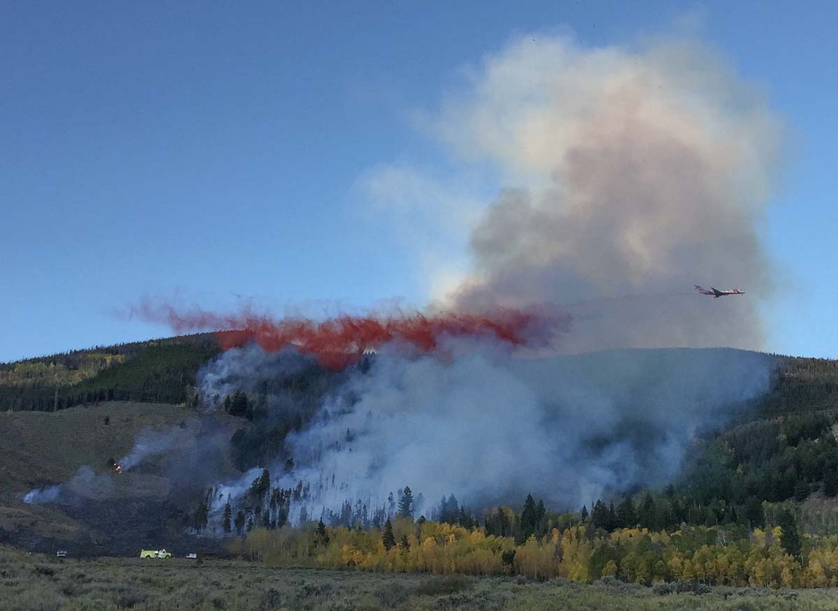
Jeff Wilson sent us the excellent photo above taken September 19 of an MD-87 dropping on the Tenderfoot 2 Fire east of Dillon, Colorado. Thanks Jeff!
The fire was reported above Dillon Reservoir at 5 p.m. MDT September 18 and burned 21 acres on a steep slope before firefighters contained it, aided by two large air tankers and two helicopters dropping water and retardant September 18 and 19.
Resources working on the fire included Lake Dillon Fire-Rescue crews, one U.S. Forest Service engine crew, a 20-person hand crew from Rifle, and a 22-person initial-attack hand crew from the Upper Colorado River Fire Management Unit.
The fire was caused by sparks from a blown insulator cap on a power line that subsequently ignited nearby grasses.
An MD-87 air tanker drops on the Tenderfoot 2 Fire September 18, 2017. Inciweb photo.
Jeff Wilson runs a professional photography studio out of Dillon, Colorado.
A roadside memorial is growing for U.S. Forest Service firefighter who was killed in a vehicle accident August 31 in California.
Above: Roadside memorial for Chief Gary Helming who was killed in a vehicle accident near this location August 31, 2017. Photo by John Szalay, September 17, 2017.
(Originally published at 10:38 a.m. MDT September 25, 2017)
Gary Helming, a Battalion Chief with the Los Padres National Forest in southern California, was returning from a wildfire on the Sierra National Forest when a Ford F-350 traveling in the opposite direction suffered a tire failure, crossed the middle of the road, and struck his vehicle head-on. Chief Helming was killed and the other driver, Antonio Avalos of Santa Maria, was airlifted to a hospital.
The accident occurred on Highway 41 just south of state Route 33 in Kings County, California.
Chief Helming had been released the previous evening from the Railroad Fire on the Sierra National Forest.
Roadside memorial for Chief Gary Helming who was killed in a vehicle accident at this location August 31, 2017. Photo by John Szalay, September 17, 2017.
John Szalay took the above photos September 17, 2017 of the memorial that has developed near the accident site. He said it is on State Route 41 less than two miles south of State Route 33. There are large turnouts on both sides of the road in case others would like to stop and pay their respects, he said.
Chief Helming started out as a seasonal firefighter and spent 22 years with the U.S. Forest Service. During his career, he also worked with the Bureau of Land Management and the National Park Service but returned to the USFS in 2013. He was stationed in Santa Maria as Battalion Chief with the Los Padres National Forest. His wife, Andrea, has served as Air Tanker Base Manager for the agency at Santa Maria. They have three children.
On January 21, 2015 Chief Helming was honored by the Santa Maria Elks Lodge as Outstanding Firefighter of the Year for Los Padres National Forest’s Santa Lucia Ranger District.
Chief Gary Helming, February 4, 2015. USFS photo.
Thanks and a tip of the hat go out to John. Typos or errors, report them HERE.
By Thursday night the Winter Valley Fire had burned 5,200 acres.
(UPDATED at 3:11 p.m. MDT September 22, 2017)
U.S. Highway 40 that was closed by the Winter Valley Fire in northwest Colorado has opened, according to the Bureau of Land Management.
****
Map showing the perimeter of the Winter Valley Fire at 6:55 p.m. MDT September 21, 2017. BLM.
(Originally published at 11:28 a.m. MDT September 22, 2017)
A fire that was reported around noon Thursday just southeast of Elk Springs, Colorado spread quickly during the afternoon pushed by very strong winds gusting up to 50 mph. During the afternoon and night the wind was out of the south and southwest as the fire crossed Highway 40 and marched 10 miles to Cross Mountain to come within 15 miles of Maybell, Colorado.
The Calico weather station northwest of Elk Springs where these wind readings were recorded detected a major shift in conditions Friday morning. At 7 a.m. the wind had calmed to a slight breeze from the west and the relative humidity that had plummeted to 14 percent on Thursday had risen by 9:53 a.m. to 79 percent. The station also measured 0.02″ of precipitation at that time. A weather station in Dinosaur National Monument about 30 miles to the northwest of the fire recorded 0.15″ of precipitation Friday morning.
At about 9 p.m. on Thursday the Bureau of Land Management reported that the fire had burned 5,200 acres and was actively burning on Cross Mountain.
The incident closed U.S. Highway 40 in both directions after 2 p.m. from Maybell to Elk Springs, according to the Colorado State Patrol.
A BLM spokesperson said about 25 to 30 residences in the Deerlodge area were threatened by the fire and evacuations took place Thursday.
The brown and red dots represent heat detected by a satellite as late as 2:47 a.m. (the red dots) September 22, 2017. The brown dots were detected at 2:30 p.m. September 21. However, the fire is many times larger than shown here because the light fuels in the area burn quickly and can cool before the next satellite overpass, which happens about twice a day.
The fire, in BLM jurisdiction, is being managed by a Type 3 Incident Management Team. The agency reports that about half a dozen gas wells were within the perimeter of the blaze. A Federal Aviation Administration tower was also threatened.
Photo from Google Maps in the general area where the Winter Valley Fire crossed U.S. Highway 40.
About 150 personnel, including two Hotshot crews, are assigned or en route to the fire Friday.
Downtown Maybell, Colorado, about 15 miles northeast of the fire. Photo from Google Maps.
The National Weather Service has issued Red Flag Warnings in only one state today, Colorado.
The map was current as of 10:15 a.m. MDT on Friday. Red Flag Warnings can change throughout the day as the National Weather Service offices around the country update and revise their forecasts.