(Originally published at 9:51 p.m. PDT October 13, 2018)
Wildland firefighters in Oregon and other locations are increasingly using technology to streamline dispatching, map fires, communicate, detect fires, and enhance situational awareness. An article at the Mail Tribune covers advances in fire detection, drones, mapping, and satellite imagery. Below are two excerpts.
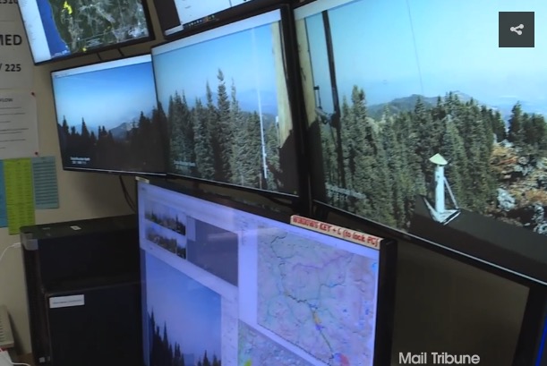
…It’s called the detection center, and ODF employees who man its viewing stations are constantly on the lookout for just-sparked wildfires.
“Typically, what we’re looking for are slight movements,” [Chris] James says while gesturing at a bank of monitors that displays multiple views of the region’s hazy, forested landscape.
Each monitor contains four pictures that rotate through on the screens and are spaced over time, giving ODF workers the ability to see fires.
“We’re looking at those pictures for any sign that we don’t recognize, that we haven’t seen before, and that keys us up on smoke,” says James, a detection center supervisor.
The Bureau of Land Management utilized drone technology for a variety of purposes, including infrared heat detection, mapping, and scouting certain areas of terrain for possible fire lines. Unrelated to surveillance — but no less interesting — the agency utilized some of the unmanned aircraft to haul in supplies. The drones also were used for burnout purposes, dropping ping pong balls … which triggered a chemical reaction that ignited the plastic spheres.
We checked with Gil Dustin who leads the Bureau of Land Management Unmanned Aircraft Systems program. He said the federal land management agencies have not used drones to haul supplies. The aircraft they have been flying can only carry a few pounds at most. One day they may be resupplying firefighters with drinking water, food, fire hose, pumps, and chain saw fuel, but we are not there yet.
Mr. Dustin said years down the road helibases are going to look very different compared to what we are seeing today.
Thanks and a tip of the hat go out to Kelly.
Typos or errors, report them HERE.

Kevin, the unmanned Kmax was flown on an active incident a couple of years ago. It was integrated into the stack with Airtankers, rotors, and a drone all flying simultaneously, I had the opportunity to speak to the ATGS working the fire and he said that the concept was certainly proven by their experiment.
Matt, I know that a remotely-piloted K-MAX was demonstrated on October 14, 2015 east of Boise, ID, but it is news to me that it has been used on an active incident. What was the name, date, and location of the incident?
The military has been using unmanned K-Max helicopters to re-supply troops in Afghanistan, so I don’t see it being too long before they start using them to support firefighting operations in remote areas. The times are definitely changing!
Surprised they are not using optical recognition software to flag changes in video feeds (such software has been used for security video in prisons and similar facilities for years)
Amazing….I remember many years ago (1974) sitting on a ridgetop with LPHS Supt. Linane, looking across the canyon to a large chunk we had lined. the word “laser” was somewhat new then. Linane said “in our lifetime, we may see it become possible to stand on a ridge and build fireline with some kind of energy beam or laser.”
I had my doubts then, but not anymore.jw