(UPDATED at 8:07 p.m. PST November 15, 2018)
Thursday evening fire authorities updated some of the information about the Camp Fire which has devastated areas around the town of Paradise, California. According to the Butte County Sheriff’s Office the number of fatalities has risen to 63, an increase of 7 over the last 24 hours. And surprisingly, the number that are unaccounted for changed from 130 to 631. Some of those could be in shelters, relocated to another part of the state, or without means of communication.
As of Thursday evening the fire has destroyed 9,700 single residences, 118 multi-residences, and 290 commercial structures, for a total of 10,108 buildings.
According to CAL FIRE, the Camp fire has burned 141,000 acres, an increase of exactly 1,000 acres in 24 hours.
(Originally published at 8:25 a.m. PST November 15, 2018)
A total of more than a quarter of a million acres have burned in the Woolsey and Camp Fires in California.
About 460 workers and 22 cadaver dogs are assessing the path that the Camp Fire took as it devastated the town of Paradise in Northern California on November 8. The estimated number of homes destroyed in the blaze is fluid and keeps rising, reaching 8,756 Thursday morning with another 260 commercial structures destroyed. The fatalities the crews have discovered has risen to 56, with 130 people still unaccounted for.
To see all articles on Wildfire Today about the Woolsey Fire, including the most recent, click HERE. For the Camp Fire, click HERE.
For the last several days the Camp Fire has continued to spread on the north and east sides, at a slower rate than earlier, but still adding thousands of acres each day. CAL FIRE is saying the fire has burned 140,000 acres.
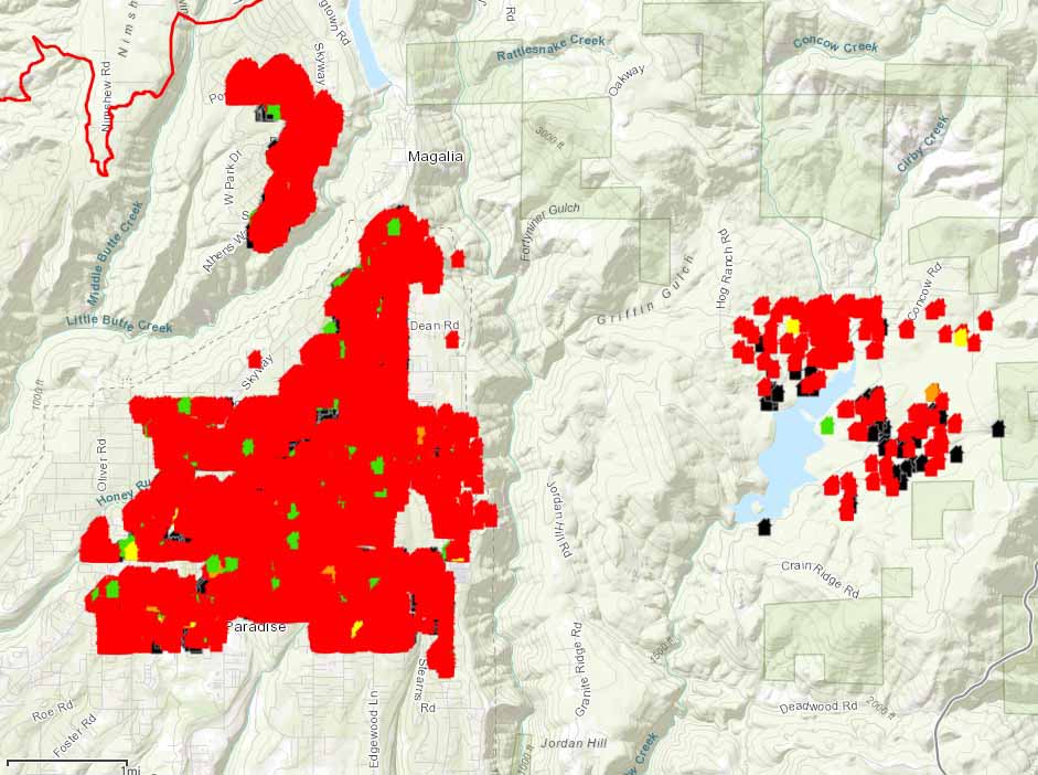
ESRI and CAL FIRE, working with local emergency service providers, have established a mapping system that displays the status of structures affected by the Camp Fire. It is still a work in progress and is far from complete, as the workers survey the more than 10,000 homes in the Paradise and Magalia areas. Residents can view the map and search for addresses at the internet site.
Some of the refugees from the Camp Fire who have not been allowed into the burned area are living in temporary shelters and camping in parking lots of Walmart and other businesses.
In southern California, the Woolsey Fire has grown very little in the last couple of days, but unburned islands of vegetation occasionally ignite and put up substantial smoke columns. Officials estimate that 504 structures have been destroyed, but a survey that was 25 percent complete Wednesday evening found 370 that were confirmed to have burned. The numbers have not been broken out by residences, outbuildings, and commercial structures.
At about 12:20 Thursday morning a firefighter on the Woolsey Fire was struck by a passing civilian vehicle on the Pacific Coast Highway and was flown to Los Robles Regional Medical Center in Thousand Oaks. The injuries for the firefighter, who was from South Kitsap Fire and Rescue in Washington, were non-life threatening. Officials said it was not a hit and run incident.
On Wednesday fire officials raised the death total to three on the Woolsey Fire. CAL FIRE is saying the blaze has burned 98,362 acres.

W.T.F.??? A couple hours on the internet and no map or list of damage structures in either fire??? I need to dump a few browsers!
Dee
The most recent articles about the fires are here: Camp Fire and Woolsey Fire
Your map says it’s updated often and I’m seeing a map that hasn’t been updated since November 14th we really need to find out if our area has burned and can’t get any information can you tell me when it will be updated with the most current information you’re trying to move forward and can’t do so until we can get confirmation and it seems like this entire area off Quail Way is not showing anything any help would be greatly appreciated
Which fire and which maps are you referring to? If it is the Paradise Fire, we posted a new map today. If you are referring to the map by CAL FIRE and ESRI that shows the status of structures, we, Wildfire Today, have no control over that map. We have never promised to update any map we produce “often”.
I am sorry for your loss and hope you find the help you need.
that website was very helpful to my family,we were able to see that my uncles home (he has passed away),his daughter still lives there and we havent heard from her,and cant contact any other relitives.
left out his home was burnt,