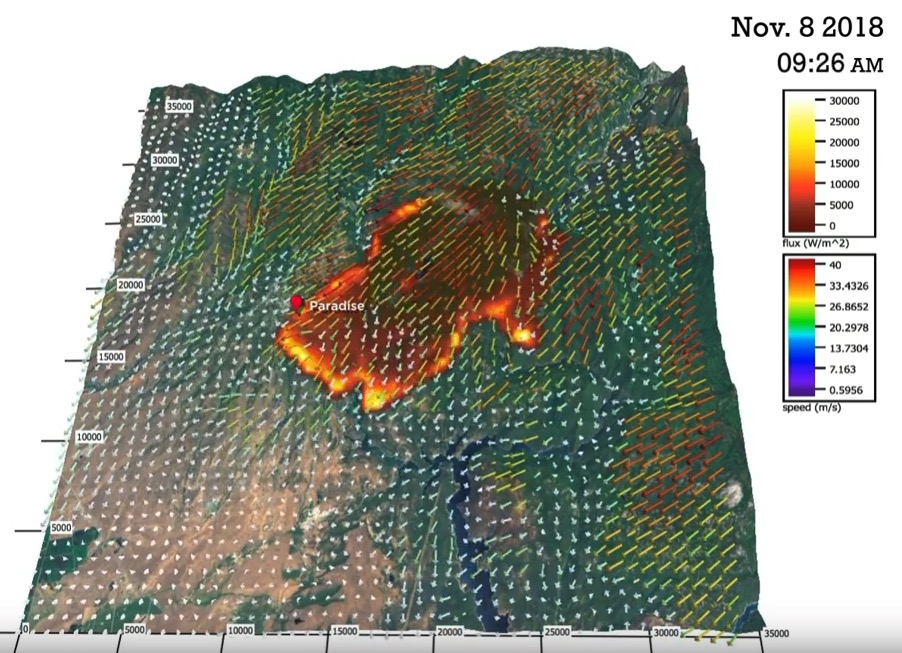
The Coupled Atmosphere-Wildland Fire Environment modeling system was used to produce the video below to show how it would predict the spread of the Camp Fire that burned through Paradise, California November 8, 2018.
This simulation of the first 8 hrs of the #CampFire was created using our CAWFE model (Coupled Atmosphere-Wildland Fire Environment).
The animation will help us understand the factors that made this #fire so deadly.#Paradise#CalFire
About CAWFE: https://t.co/i1196hVIC5 pic.twitter.com/xLMHmLUTWy
— NCAR Science (@NCAR_Science) December 31, 2018
The CAWFE modeling system combines a numerical weather prediction (NWP) model that predicts how weather varies in time and space even in complex terrain with wildland fire behavior modules. These components are connected in two directions such that the evolving wind, along with fuel properties and terrain slope, directs where the fire grows and how fast, while heat released by the fire modifies its atmospheric environment thereby creating its own weather (e.g., fire-induced winds). The model is described in Clark et al. (2004) and Coen 2005a. Coen (2013) documents the model equations.
CAWFE was developed recognizing that fires interact with the atmosphere surrounding them and that this produces many fundamental fire behaviors. Research applying CAWFE showed that fire-atmosphere interactions produce numerous wildland fire phenomena, including the commonly-observed bowed shape (below); the heading, flanks, and backing regions; fire whirls; horizontal roll vortices.
Here is another copy of the video, on Google Drive.
The CAWFE was developed by Janice Coen and other scientists at the University Corporation for Atmospheric Research, as well as Don Latham (formerly USFS, Missoula), Francis Fujioka (formerly, USFS Riverside), Phil Riggan (USFS), and David Packham (Bureau of Meteorology in Australia).

Would be great if you overlay the model with the actual fire perimeter to see how it performed. Looks a little south of actual perimeter? Any comments on how it performed?
You’re getting to the heart of the problem with fire modeling- the model has to be developed in conjunction with real-life mapping of the fire extent and activity in order to check the model’s accuracy and refine the model parameters. The nightly fire perimeter maps provided by the NIFC overflights are useful, but more frequent fire front mapping during the hours when the fire is most active is desirable. I did not work with Dr. Coen on the Camp Fire model, but I have worked with her on other fires where she has had access to maps produced from repeated daytime airborne thermal IR mapping flights. See her publication on the 2006 Esperanza Fire- http://www.researchgate.net/publication/273741049_Simulation_and_thermal_imaging_of_the_2006_Esperanza_Wildfire_in_southern_California_Application_of_a_coupled_weather-wildland_fire_model.