Modeling the spread of the Camp Fire

Using the Coupled Atmosphere-Wildland Fire Environment modeling system

model simulation spread Camp Fire
CAWFE

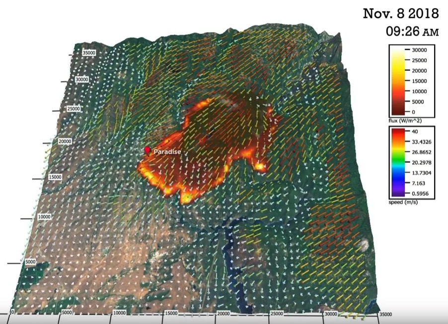
The Coupled Atmosphere-Wildland Fire Environment modeling system was used to produce the video below to show how it would predict the spread of the Camp Fire that burned through Paradise, California November 8, 2018.


About the modeling system:

The CAWFE modeling system combines a numerical weather prediction (NWP) model that predicts how weather varies in time and space even in complex terrain with wildland fire behavior modules. These components are connected in two directions such that the evolving wind, along with fuel properties and terrain slope, directs where the fire grows and how fast, while heat released by the fire modifies its atmospheric environment thereby creating its own weather (e.g., fire-induced winds). The model is described in Clark et al. (2004) and Coen 2005a.  Coen (2013) documents the model equations.

CAWFE was developed recognizing that fires interact with the atmosphere surrounding them and that this produces many fundamental fire behaviors. Research applying CAWFE showed that fire-atmosphere interactions produce numerous wildland fire phenomena, including the commonly-observed bowed shape (below); the heading, flanks, and backing regions; fire whirls; horizontal roll vortices.

Here is another copy of the video, on Google Drive.

The CAWFE was developed by Janice Coen and other scientists at the University Corporation for Atmospheric Research, as well as Don Latham (formerly USFS, Missoula), Francis Fujioka (formerly, USFS Riverside), Phil Riggan (USFS), and David Packham (Bureau of Meteorology in Australia).


Better satellite imagery enables improved wildfire mapping and growth predictions

Higher resolution imagery becoming available from satellites will enable more accurate mapping and spread prediction of wildfires.

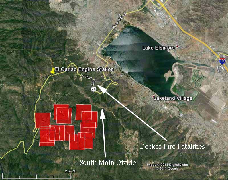
Higher resolution imagery becoming available from satellites will enable more accurate mapping and spread prediction of wildfires. Since we created Wildfire Today in 2008 we have frequently displayed maps showing fire data collected by the Moderate-resolution Imaging Spectroradiometer (MODIS) instrument package, such as the one below of the Falls Fire near Elsinore, California in August. The red squares represent heat detected by MODIS before the fire spread east across the South Main Divide and down through the bowl where the Decker Fire fatalities occurred in 1959. Click on the image to see a larger version.

Map of Falls Fire at 1:47 p.m. PDT, August 5, 2013
Map of Falls Fire at 1:47 p.m. PDT, August 5, 2013, showing heat detected by a satellite. The red squares indicating heat can be as much as a mile in error. (click to enlarge)

MODIS, launched in 1999 with its 1,000-meter resolution system, is starting to show its age. Better technology is now available and is orbiting 512 miles above the Earth on the Suomi National Polar-orbiting Partnership (Suomi NPP) satellite launched October 28, 2011 . The Visible Infrared Imaging Radiometer Suite (VIIRS) on the satellite is a 22-band radiometer designed to collect infrared and visible light data to observe wildfires, movement of ice, and changes in landforms. It has a resolution of 375 meters, much better than the MODIS. The new Landsat 8 satellite launched in February has a resolution of 30 meters for most of its sensors, and 100 meters for thermal infrared. This will be a game changer. In March we published a test image of the Galena Fire taken with Landsat 8.

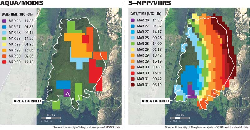
Below is a comparison of data from MODIS and VIIRS. Click on it to see a larger version.

VIIRS vs MODIS
When observing wildfires, satellites provide different levels of detail, depending on which instrument is used. The image at left, produced from data generated by the MODIS instrument aboard NASA’s Aqua satellite, uses 1-kilometer pixels (a bit over half a mile across) to approximate a fire burning in Brazil from March 26 to 30, 2013. The image at right, produced with data from the new VIIRS instrument, shows the same fire in far greater detail with 375-meter pixels (a bit over 1,200 feet across). (Image courtesy Wilfrid Schroeder, University of Maryland.)

Last month we told you about a proposed satellite, called FUEGO – Fire Urgency Estimator in Geosynchronous Orbit, which would survey the entire western United States every two minutes or less and could detect a fire that is about 10 feet in diameter. Assuming that the data from the satellite could be transmitted to the appropriate dispatch center within a minute or two, this could be a major step toward keeping fires small… IF the fire agencies have the appropriate initial attack policies in place and an adequate number of firefighting resources, both ground and air-based, to respond and arrive at the fire within the first 10 to 30 minutes. But since the cost of the satellite could be several hundred million dollars, it probably will never be built or launched.

Two scientists who have been working with some of the new data that is available now are Janice Coen of the National Center for Atmospheric Research in Boulder, Colorado, and Wilfrid Schroeder with the Department of Geographical Sciences, University of Maryland. They intend to transition the new refined spatial resolution VIIRS and Landsat-8 fire detection data and a new weather forecast-fire spread model into operations in the next two to three years. Mr. Schroeder told us that some of the higher resolution data should replace the MODIS data on the GEOMAC website in the next one to two months. In the meantime you can see some early versions of it on an experimental basis at a website they created.

The two of them recently published a paper documenting the development of a new wildfire spread model (think newer version of BEHAVE) that, coupled with high resolution numerical weather prediction and the actual location of a fire as detected by the 375-meter resolution VIIRS, predicts the fire behavior and spread of a fire, displaying it on a map. The model can be run after the overflights of the satellite every 12 hours using updated weather forecast information and the current location of the fire.

Their paper is HERE, and a description of the concept written by Ms. Coen is below.
Continue reading “Better satellite imagery enables improved wildfire mapping and growth predictions”

Supercomputer model of Esperanza fire

The video below is a simulation of the spread of the Esperanza fire which killed five U.S. Forest Service firefighters in 2006 near Cabazon, California. Raymond Lee Oyler was sentenced to death after he was convicted of five counts of murder and 37 counts of arson for starting this fire and many others.

The simulation was produced by Janice L. Coen of the National Center for Atmospheric Research and Philip J. Riggan of the Pacific Southwest Research Station.

The description of the video which is on YouTube:

===================================================

It takes a supercomputer to run a mathematical simulation, or model, of the complex processes observed in wildfires. It often takes yet more computing power to visualize the data coming out of the computer model. This fire-behavior simulation reproduces the October 2006 Esperanza Fire near Cabazon, California. Using data from the NCAR fire-weather model, simulations like this one are helping scientists explain the physical processes and behavior within large wildfires.

An arsonist ignited the blaze on the upwind edge of Cabazon Peak during a Santa Ana wind event. Driven by gusty Santa Ana winds, dry chaparral fuels, and steep terrain, the fire rapidly spread up into the San Jacinto Wilderness.

The simulation reproduces several features observed during the fire: the rapid spread to the west-southwest, runs of flame up canyons that lay perpendicular to the wind direction, splitting of the fire into two heads, and feathering of the fire line at the leading edge.

—–Coupled Weather-Fire Simulation of the Esperanza Wildfire—–

Science: Janice Coen (NCAR) and Phillip Riggin (Pacific Southwest Research Station, USDA Forest Service)

Visualization: Janice Coen and Alan Norton, NCAR, using VAPOR (Visualization and Analysis Platform for Ocean, Atmosphere, and Solar Researchers) http://www.vapor.ucar.edu

More information:http://www.mmm.ucar.edu/people/coen/files/newpage_m.html

****

UPDATE November 12, 2013:

Esperanza Fire Factual Report, and the USDA Office of Inspector General’s Report on the fire.