Images from the volcano eruption in Hawaii

The eruption of the volcano on the Big Island in Hawaii is certainly tragic for the owners of the 26 homes that have been destroyed and the 1,700 residents of Leilani Estates that have been forced to evacuate. We are not going to try to cover the incident like we would a large vegetation fire — primarily because it is very difficult to obtain the kind of information we would normally collect about a fire. We have made some inquiries with a couple of agencies but distributing information to the media could be pretty far down their list of priorities. They no doubt have their hands full.

But we have found a bit of information about what is going on there. Approximately 104 acres are directly affected by vents, fissures, or 2,000F-degree lava. The activity paused for a bit Monday, but Tuesday morning two additional fissures developed, bringing the total to 14 and requiring the total evacuation of  Lanipuna.

Previous eruptions on the island have ignited vegetation fires, but while we have seen some trees and shrubs burning in videos, it seems to mostly be when they are directly contacted by the molten lava.

A friend of ours has been in Hawaii for at least a week and most of the numerous photos he has posted on Facebook have shown cloudy skies. The weather Monday and Tuesday at Hilo included rain with humidities in the 90’s, so until that changes there might not be much of a wildfire threat.

If any of our readers have confirmed information about resources assigned or an Incident Command System being used, let us know in the comments.

Here is a link to a live camera.

I don’t know what Hell looks like, but….. the video below of the lava in the crater is incredible.
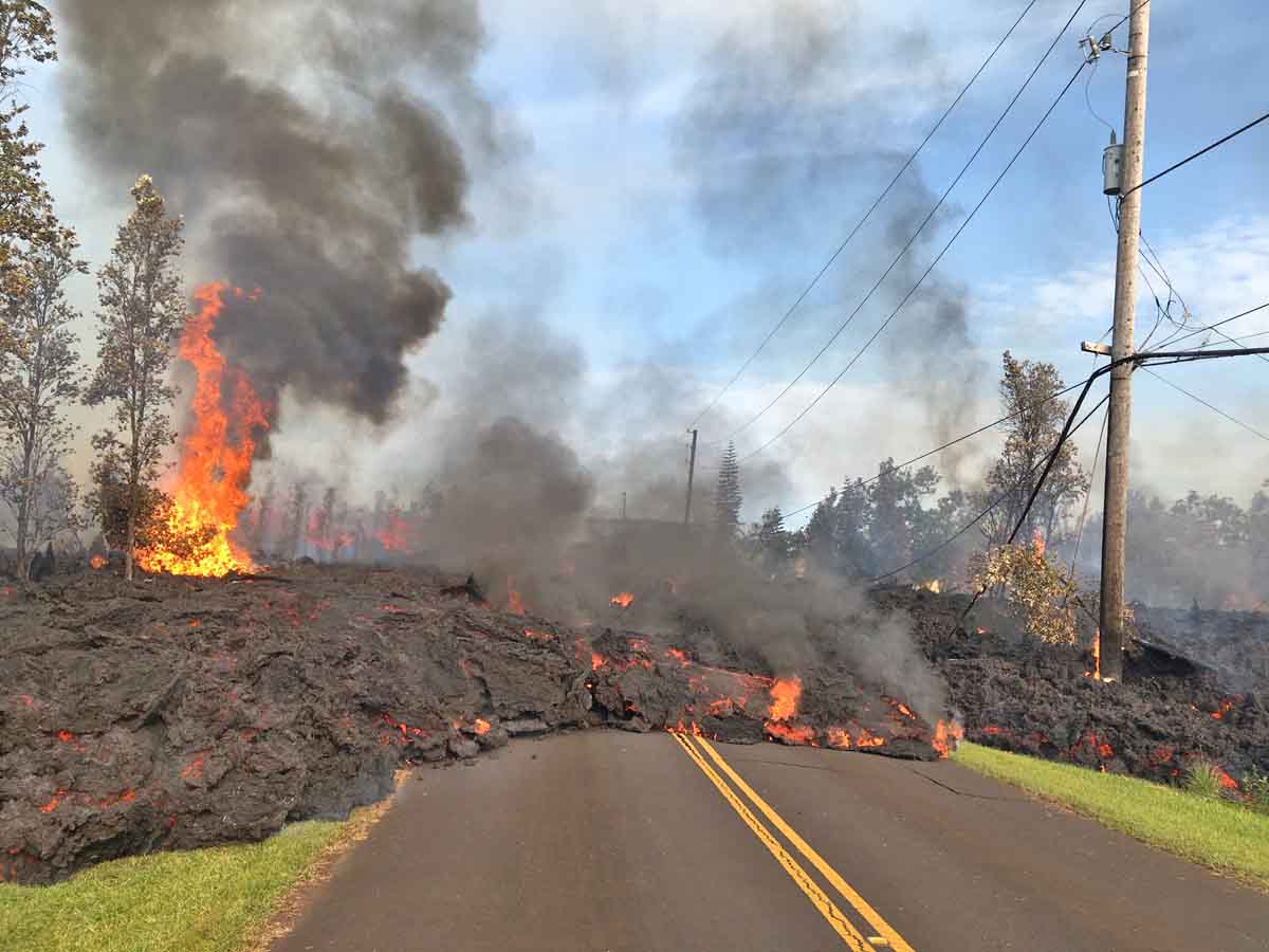
volcano photo
On May 5 lava from fissure 7 slowly advanced to the northeast on Hookapu Street. USGS photo.

Overflight in Leilani Estates: fissure 12 opens shortly after fissure 11 becomes inactive. Fissure 12 in the forest south of Malama Street. https://t.co/w5XLplnwVHpic.twitter.com/IdUmtORibY

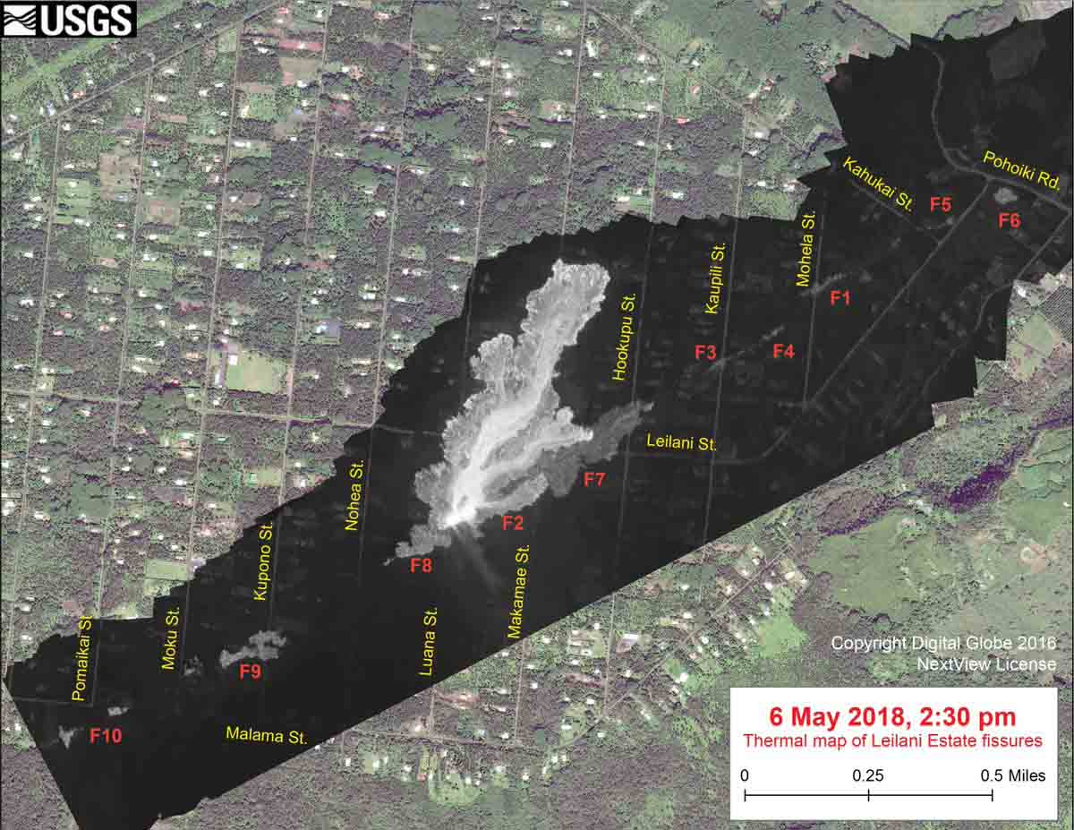
volcano May 6 map

volcano photo may 5
In the Leilani Estates Subdivision, fissure 7 was active for several hours on May 5 with large bubble bursts and spatter. A short lava flow moved northeast and crossed Hookupu St. USGS photo.

Eleven CL-215’s to be converted to CL-415EAF

CL-215T

Above: Viking Air photo

Longview Aviation Asset Management (LAAM) of Calgary, Alberta, in cooperation with Viking Air Limited of Victoria, British Columbia, has launched the Viking CL-415EAF (“Enhanced Aerial Firefighter”) Conversion Program.

To initiate the program, LAAM will be hiring up to 150 technical and support staff members at its Calgary facilities, where eleven specially selected CL-215 aerial firefighting aircraft owned by LAAM will undergo the modification process utilizing Viking-supplied conversion kits.

To support development of the conversion kits, Viking has hired 50 employees to date and has launched a recruitment campaign to hire an additional 50 staff at its Victoria, BC location. Viking will also be reinstating its “Viking Academy” paid-training program to provide successful applicants with the targeted technical training required for these positions.

After acquiring the CL-215, CL-215T and CL-415 Type Certificates in late 2016, and based on feedback from the operator group, Viking elected to introduce an “Enhanced Aerial Firefighter” (EAF), mirroring the CL-215T conversion program and updating it with the addition of operator requested enhancements.

Both the CL-215T and CL-415EAF include the winglets, finlets, higher operating weights, increased capacity firebombing system, and foam injection system of the CL-415.  In addition to these standards, other improvements introduced with the Viking CL-415EAF conversion upgrade include:

  • Full modern Avionics package,
  • Component modernization improvements to address all fleet obsolescence issues,
  • Corrosion protection enhancements based on operator feedback,
  • Flight deck air-conditioning system,
  • Customized external paint scheme, and
  • Humanitarian relief and special mission options (e.g. stretcher rack, large cargo door, spray boom system)

The Viking CL-415EAF Conversion Program forms part of a staged approach to utilize the advancements made with the LAAM converted aircraft as the basis for the proposed Viking CL-515 new-production amphibious aerial firefighting aircraft.

Thanks and a tip of the hat go out to Roman.
Typos or errors, report them HERE.

New film released — “Fire: In the Florida Scrub”

Sand pine fire resistant

Above: Screenshot from the film.

In 2012 when I first heard of Jennifer Brown she was working in the Interpretation Division in Everglades National Park  and her term appointment was about to end. She had just produced for the National Park Service an excellent film about prescribed fire titled “River of Fire”. Now with many other videos about fire under her belt with her company Into Nature Films, she has produced another — “Fire: In the Florida Scrub”. As with some of her other projects, she partnered with the former Fire Management Officer at Everglades National Park, Rick Anderson.

Here is the official description of the film:

Fire is one of the earth’s dominant forces. ‘Surviving Fire: In the Florida Scrub’ features three decades of discovery by Dr. Eric Menges. After watching this powerful short film, you will never look at Florida plants the same away again. This film pays tribute to the special people who dedicate their lives to improving fire management. Join Eric Menges for a 16 minute exploration into the elegant and unexpected ways plants survive fire. Funded by the National Science Foundation (NSF) and produced by Into Nature Films in collaboration with Archbold Biological Station.

Like the other “Into Nature Films”, this one is beautifully photographed and very clearly tells the story. It’s impressive how they had video footage to illustrate almost every point brought up in the narration.

Ms. Brown’s other films can be seen at articles on Wildfire Today tagged “Jennifer Brown”.

Border collies help reseed after forest fire

border collies reseed Chile forest fire wildfire

Above:  Dog trainer Francisca Torres and her three border collies. Screenshot from the video below.

Three border collies are helping to reseed areas in Chile that burned during the siege of wildfires that blackened large sections of the country in January of 2017.

The high-energy dogs are outfitted with pouches containing native seed. As they run through the burned trees the seeds are distributed along their path.

OK Bar Fire in New Mexico is just about wrapped up

OK Bar Fire Arizona

Above: Satellite photo taken May 6, 2018, showing the OK Bar Fire in Arizona.

Firefighters are just about finished with the OK Bar Fire in the southern panhandle of New Mexico three miles from the Mexican border. They made their “final” update on InciWeb May 4, writing:

The perimeter of the fire is secure, and firefighters are patrolling the perimeter and monitoring the fire by air. Due to aggressive fire management planning by the landowner and supporting non-profit organization, fire suppression actions have been designed to maximize firefighter safety and keep costs commensurate with the values at risk. Smoke and flames will continue to be visible on the mountain until significant moisture has been received on the fire.

The management strategy was not full suppression. Sunday’s National Situation Report shows 61,436 acres burned, an increase of 188 over the day before, and 5 engines assigned, for a total of 20 personnel.

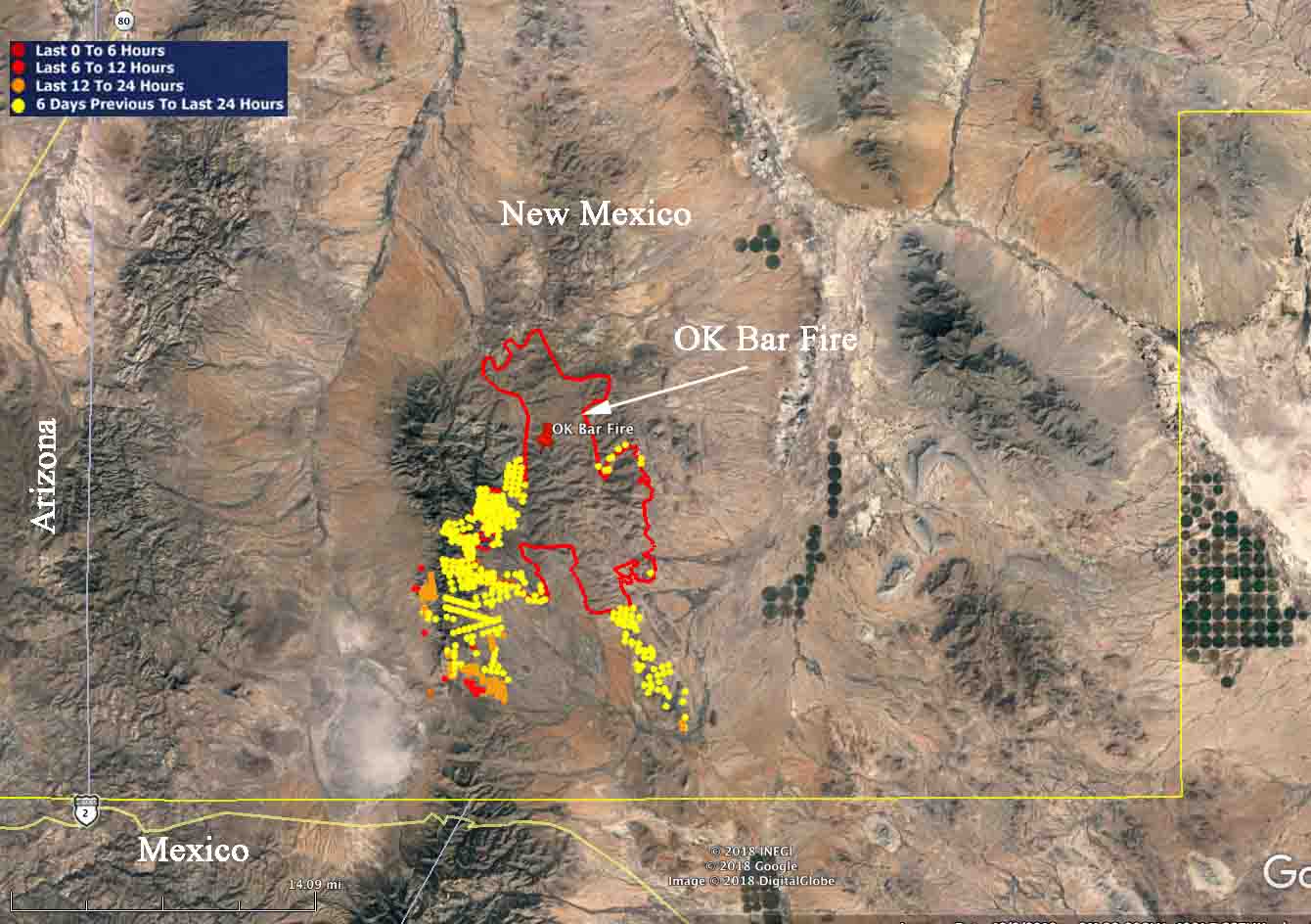
OK Bar Fire Arizona
The red line was the perimeter of the OK Bar Fire as determined by infrared mapping at 2400 MDT May 3, 2018. The red, yellow, and brown dots represent heat detected by a satellite.

Fires in Big Cypress National Park have burned over 38,000 acres

avian complex fires stats

Above: Data from the Incident Management Team, May 5, 2018.

Three large wildfires in Big Cypress National Park and Preserve in South Florida have burned a total of 38,808 acres. Along with several other small fires they are being managed as the Avian Complex.

  • Buzzard Fire, 23,914 acres: Raccoon Point 11 miles north of US 41 MM 50. It continues to be active in the northeastern and southwestern portions. The observed fire behavior Saturday was flanking fire with short head fire runs. Scattered areas received small amounts of rain that had zero effect on the fuel conditions. The passing storms brought increased winds that pushed it to the north, increasing the threat to the cabins in the Little Deer area.
  • Flamingo Fire, 4,043 acres: north of I-75, E of SR 29, S of Preserve N boundary. It was active Saturday before receiving about 1/2 inch of rain. A well developed smoke column was visible from Highway 29 and I-75. A steady flanking fire was moving north and northwest with small areas of head fire.
  • Curlew Fire, 1,062 acres: South of US 41, east and north of Loop Road. It is burning in both Big Cypress National Park and Preserve and Everglades National Park. No fire activity was observed Saturday due to additional moisture and limited fuels.
avian complex fire wildfire
Uploaded to InciWeb May 5, 2018, labeled: “Jose Martinez PR crew”.
Map of fires Avian Complex
Map of fires in the Avian Complex. Incident Management Team May 5, 2018.

NASA satellite measures height of smoke column on Tinder Fire

Tender Fire smoke satellite height

Above, image credit:NASA/GSFC/LaRC/JPL-Caltech, MISR Team

I found out today that NASA has been measuring wildfire smoke plumes for at least a decade. The nine cameras on the Multi-angle Imaging SpectroRadiometer (MISR) have been capturing imagery of the Tinder Fire as it passes overhead on NASA’s Terra satellite. With a little trigonometry it can determine the height of smoke columns. The image above shows what it came up with after analyzing the fire on April 30, the day after it made its biggest run. Strong winds on both days probably kept the smoke from rising as high as it would have under calmer conditions.

(To see all articles on Wildfire Today about the Tinder Fire, click here.)

The two photos below were taken the day before the NASA analysis described here.

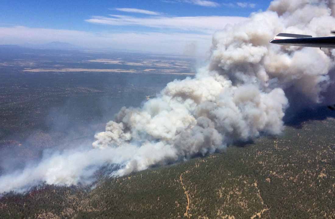
Tinder Fire
Tinder Fire, April 29, 2018. InciWeb photo, uncredited and undated.
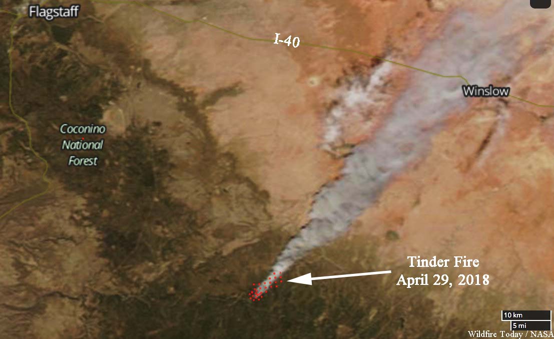
Satellite photo Tinder Fire
Satellite photo of the Tinder Fire, April 29, 2018. NASA.

Below is how NASA described the April 30 analysis:


“On April 30 at 11:15 a.m. local time, the Multi-angle Imaging SpectroRadiometer (MISR) captured imagery of the Tinder Fire as it passed overhead on NASA’s Terra satellite. The MISR instrument has nine cameras that view Earth at different angles. This image shows the view from MISR’s nadir (downward-pointing) camera. The angular information from MISR’s images is used to calculate the height of the smoke plume, results of which are superimposed on the right-hand image (Figure 1). This shows that the plume top near the active fire was at approximately 13,000 feet altitude (4,000 meters). In general, higher-altitude plumes transport smoke greater distances from the source, impacting communities downwind. A stereo anaglyph (Figure 2) providing a three-dimensional view of the plume is also shown. Red-blue glasses with the red lens placed over your left eye are required to observe the 3D effect.

“These data were acquired during Terra orbit 97691. The smoke plume height calculation was performed using the MISR INteractive eXplorer (MINX) software tool, which is publicly available at https://github.com/nasa/MINX. The MISR Plume Height Project maintains a database of global smoke plume heights, accessible at https://www-misr.jpl.nasa.gov/getData/accessData/MisrMinxPlumes2/.

“MISR was built and is managed by NASA’s Jet Propulsion Laboratory in Pasadena, California, for NASA’s Science Mission Directorate in Washington. The Terra spacecraft is managed by NASA’s Goddard Space Flight Center in Greenbelt, Maryland. The MISR data were obtained from the NASA Langley Research Center Atmospheric Science Data Center in Hampton, Virginia. JPL is a division of Caltech in Pasadena.”

I supersized it

Prime Minister Benjamin Netanyahu speaks about firefighting aircraft

I’m not sure why I have not done this before.

I have a lot of photo prints on my walls. Like other firefighters or former firefighters (is anyone ever a former firefighter?) many of them were taken at fires.

In deciding what to do with that empty space which was about six feet wide, I considered hanging two or more conventional-sized photos, 16″ x 20″ or smaller. Then I thought, why not go big — one megaphoto that would fill most of the space.

So I ordered a 48″ x 32″ canvas print of a photo I took at the Crow Peak Fire on June 27, 2016 of air tanker 161 dropping. I love seeing it on the wall.

(By the way, that photo won third place in the Professional category in the 13th annual Dahl Mountain Photo Competition in Rapid City. There were 215 entries.)

Photography Prints