
At least 54 outbuildings also burned, for a total of 87 structures
Continue reading
At least 54 outbuildings also burned, for a total of 87 structures
Continue reading
Above: The Voltage Fire, undated photo, credit: U.S. Fish & Wildlife Service.
Firefighters are making progress on a wildfire that started April 27 in Malheur National Wildlife Refuge in Oregon, but it sounds like there will be extensive mopup since it is burning in heavy tule marsh vegetation. Firefighters are using roads, canals, open water, and nonburnable vegetation for control opportunities.
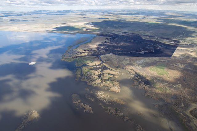
Here is the latest information about the Voltage Fire issued Thursday by the Refuge:
The fire started April 27 from a lightning strike, and burned approximately 1,500 acres. Firefighters are continuing to suppress the wildfire in organic soils, and will be conducting interior burn out operations today to remove the immediate threat to control lines. Photo credit: Peter Pearsall, Friends of Malheur National Wildlife Refuge.


Above: One of Washington DNR’s UH-1H helicopters. Washington DNR photo.
The Washington Department of Natural Resources is getting their fleet of eight helicopters ready for the coming wildfire season. The agency began acquiring their military surplus UH-1H (B-205) ships in 1989.
The DNR started their helicopter program in the 1960’s with two Bell-47’s used for recon and carrying a 50-gallon water bucket which was designed by one of their pilots, Harold Clark. By the mid-1970’s the Kaman Husky, which could carry up to 450 gallons, replaced the Bell-47’s. Those six Kaman’s were phased out in the late 1970’s due to a shortage of spare rotor blades and the availability of the more reliable and faster Huey UH-1B, which were replaced by the UH-1H about 10 years later.
 A Washington DNR Kaman Husky from the 1970’s. It had interlocking rotors, not unlike the present day Kaman K-MAX. DNR photo.
The agency now has a program manager, one helicopter coordinator, 11 U.S. Forest Service certified helicopter pilots, 6 aviation maintenance technicians (AMT) who maintain, and configure the aircraft, and one chief pilot who leads the team. Usually 7 helicopters are deployed, with one held in reserve as a spare.
All of the pilots have current Class II Medical Certificates and FAA Commercial Rotor Wing Certificates. Many maintain an FAA Certified Instrument Instructor rating and Airline Transport pilot certification.
In addition to the pilots and mechanics, the staffing includes one transportation supervisor, 7 helicopter managers, 7 squad leaders, 14 firefighters, and 8 support drivers. All helitack modules have an incident commander. Generally they stage at Omak, Deer Park, Dallesport, Pomeroy, Wenatchee, Colville and Olympia.
 Maintenance on Washington DNR’s UH-1H helicopters. DNR photo.
Below is an excerpt from an article at Spokesman.com:
The department pays for fuel, operations and maintenance, which works out to about $1,600 an hour when they fly.
Dropping water on forest fires can be rugged work. But while these “Hueys” are old – the most senior helicopter in the DNR fleet came off the factory line in 1963 and did two tours in Vietnam, where it was shot down twice – they’re extremely reliable and spare parts are plentiful.
 Washington DNR photo

The fire is 13 miles west of Fort Davis, Texas.
Continue readingPersonnel are mopping up in some areas, but Southwest Incident Management Team #1 reports “zero percent” of the fireline is contained.
Continue reading
Above: 3D map of the McDannald Fire showing the approximate perimeter at 4:23 a.m. CDT May 2, 2018.
(Originally published at 10:55 a.m. CDT May 2, 2018)
The McDannald Fire 13 miles west of Fort Davis, Texas was very active Tuesday and early Wednesday morning. Pushed by 10 to 20 mph winds out of the south and southwest it spread to within a mile west of Tomahawk Trail on the east side of the fire.
Our very unofficial estimate based on heat detections Wednesday morning by a satellite put it at about 18,000 acres. Most if not all of the fire is north of Highway 166.
Officials estimate that 400 homes are threatened. Evacuations are ongoing in the Davis Mountain Resort community.
The area is under a Red Flag Warning Wednesday for strong southwest winds of 16 to 30 mph gusting above 40 mph along with relative humidity in the mid-teens. These conditions could be conducive to the fire continuing to spread to the northeast toward Davis Mountain Resort. The McDonald Observatory is 8 miles northeast of the fire.
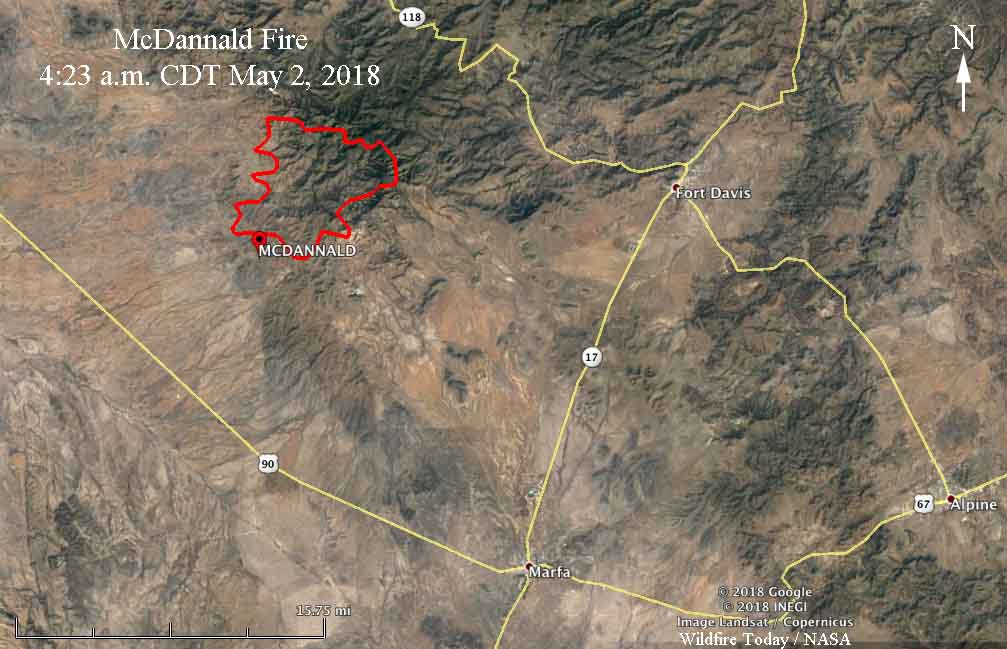
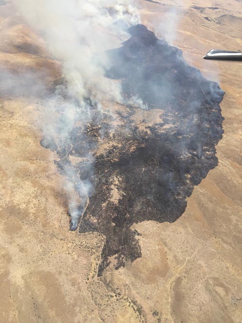
The Texas Forest Service reports that lightning started the fire on Monday. A Type 1 Incident Management Team with Incident Commander Mike Dueitt is mobilizing.

The National Weather Service has issued Red Flag Warnings or Fire Weather Watches for areas in Colorado, Kansas, Oklahoma, Texas, New Mexico, New York, Pennsylvania, and New Jersey.
The map was current at 8:15 a.m. MDT on Wednesday. Red Flag Warnings can change throughout the day as the National Weather Service offices around the country update and revise their forecasts.

Above: Blue Sky’s prediction for PM2.5 particulate matter for May 1, 2018.
Smoke from four large wildfires, agricultural burning, and prescribed fires are pumping a great deal of smoke and particulate matter into the atmosphere. These maps, created by the Forest Service’s Blue Sky program, show predictions for the amount of very small smoke particles, 2.5 micrometers in diameter or smaller, which can only be seen with an electron microscope. Fine particles, known as PM 2.5, are produced from all types of combustion, including motor vehicles, power plants, residential wood burning, forest fires, agricultural burning, and some industrial processes.

The Tinder Fire has burned 11,420 acres in central Arizona and is being suppressed.
The OK Bar Fire in extreme southern New Mexico is 44,000 acres and is not being fully suppressed.
A Type 1 Incident Management Team has been ordered for the 2,000-acre McDannel Fire in west Texas 21 miles west of Ft. Davis.
The 5,800-acre North County Road 7 Fire is burning in northern Minnesota five miles south of the Canadian border 11 miles northwest of Greenbush. The fuels burning are mostly grass and swampland, said Christi Powers, an information officer for the Minnesota Interagency Fire Center in Grand Rapids, Minn.

(Originally published at 12:03 p.m. MDT May 1, 2018)
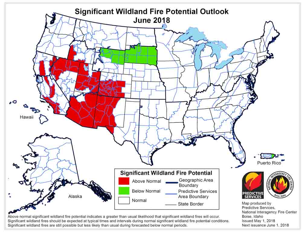
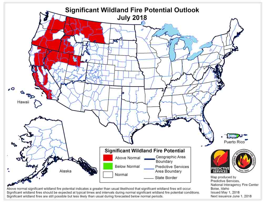
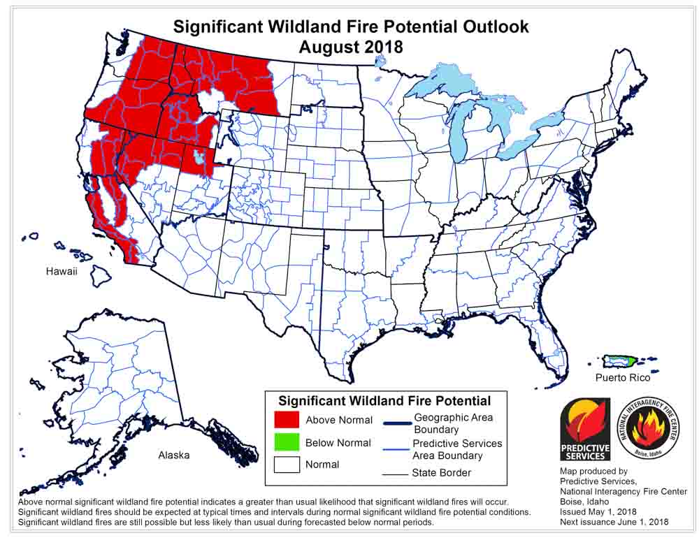
On May 1 the Predictive Services section at the National Interagency Fire Center issued their Wildland Fire Potential Outlook for May through August. The data represents the cumulative forecasts of the ten Geographic Area Predictive Services Units and the National Predictive Services Unit.
If their analysis is correct, in July and August California, the northwest, and the northern Rockies will experience above normal wildfire activity.
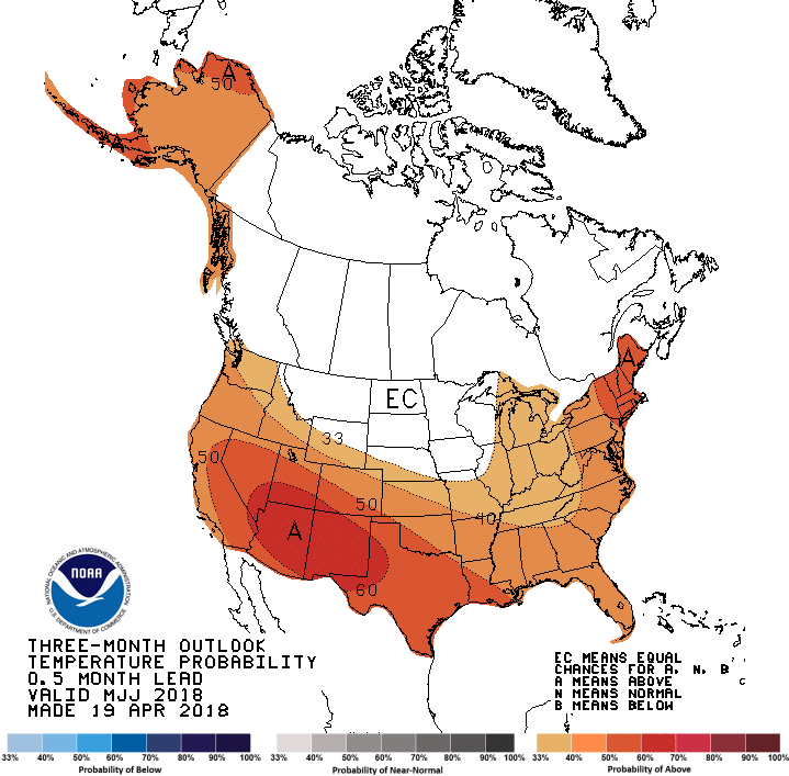
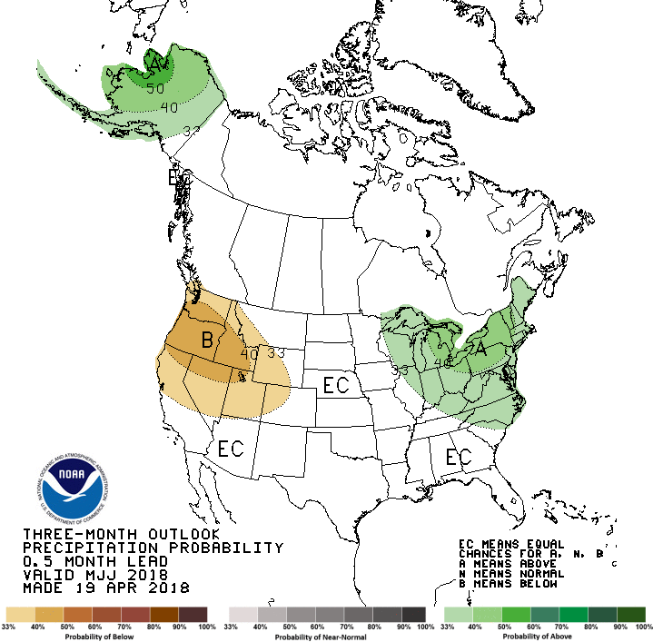
Below are:
“The significant wildland fire potential forecasts included in this outlook represent the cumulative forecasts of the ten Geographic Area Predictive Services units and the National Predictive Services unit.
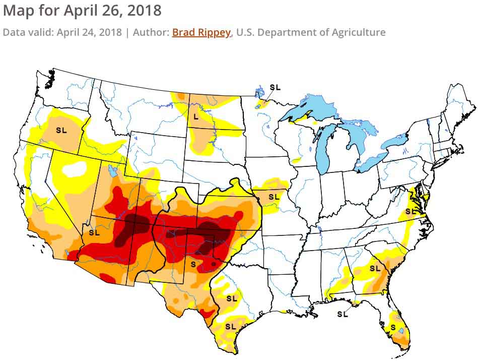
“Preexisting drought conditions along with several wind events allowed for fire activity across the southern Great Plains and New Mexico to increase in April. By month’s end, activity was beginning to spread westward into Arizona and southern California. Entering May, a normal progression of fire activity is being observed as the Great Plains begins to receive its spring rainfall while the Southwest continues to be dry. What is atypical is the drought severity that is in place across the Four Corners Region and now southern California. The drought coupled with the carryover of an above average fine fuel growth from last year is expected to lead to Above Normal Significant Wildland Fire Potential in May and June across portions of the Southwest, Great Basin, and southern California. In the East, the elevated potential across Florida and portions of Georgia will return to Normal potential as summertime convective patterns ensue.
“The peak of the fire season in the Southwest is expected to occur by late June, just before the onset of the annual monsoon season which should gradually bring their season to a close. Data suggests that the monsoon’s arrival should occur by early July. The projected focus of the monsoon’s early surges will be across New Mexico and Colorado but will refocus westward as July progresses. A normal transition of fire season activity west and north is expected through July as warmer and drier than average conditions develop across the western states. Of concern is the preexisting grass crop from 2017 and the new growth which will cure by July across California, the Great Basin, and Oregon. Higher, timbered elevations in these areas will become a concern by July as the past winter’s below average snowpack melts allowing for the high elevation fuels to become dry enough to support fire activity.
“In August, seasonal transitions focus the fire activity over the northwestern quarter of the country, though central and southern California also continue to experience significant activity. With significant carryover of fine fuels from last year and average grass crop growth this year, elevated fire potential will continue into August across many of the lower and middle elevations from the central Great Basin and California northward to Canada. Higher elevations in the Cascades, Northern Sierras, and possibly the Northern Rockies may also see elevated fire potential as well should warmer and drier than average conditions develop as expected.
“In Alaska, Normal Significant Wildland Fire Potential is expected as the state experiences a typical transition into fire season. Conditions across the state have been generally wetter than average while temperatures have been warmer than average. Since this pattern is expected to continue through the core of the Alaskan fire season, the potential for Above Normal Significant Wildland Fire Activity is low.”

Above: Screenshot from the video.
This is the best description I have seen of the Modular Airborne FireFighting System (MAFFS) — the crews, aircraft, retardant delivery system, and the mission. The 3,000-gallon tank can be installed in a military C-130 in a few hours when additional air tanker surge capacity is needed for assisting wildland firefighters.
In 2017 there were 20 large air tankers on exclusive use contracts. This year there are 13, so we might be seeing more military aircraft fighting wildfires in 2018. In 2002 there were 44 on contract.
Thanks and a tip of the hat go out to Nigel.
Typos or errors, report them HERE.