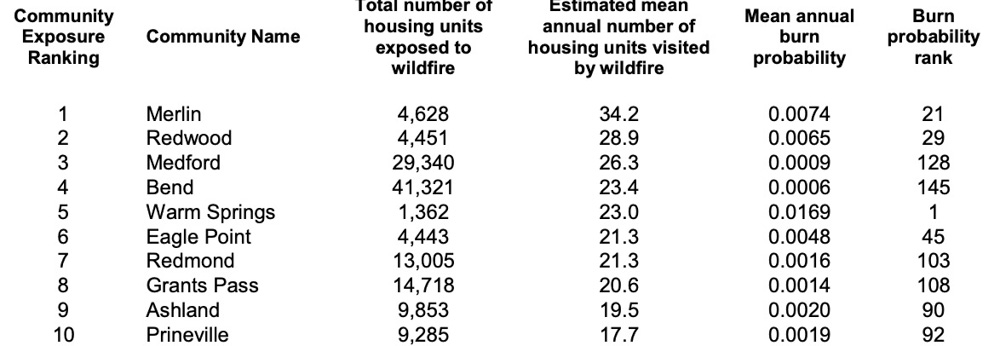
After assessing the exposure to wildfire of communities across the Pacific Northwest Region, Oregon and Washington, the 50 most-threatened communities in each state were identified.
In the broadest sense, wildfire exposure encompasses the likelihood of wildfire burning a given location on the landscape, and the potential intensity of a wildfire if one were to occur. For this assessment the researchers focused only on wildfire likelihood because the effect of fire intensity on home loss rate is not well studied, and because the inclusion of intensity for this and similar assessments did not influence the conclusions. Wildfire likelihood is measured by annual burn probability, a measure generated by comprehensive simulation of wildfire occurrence and spread (see section below on Wildfire hazard simulations).


“mean of exposed housing units” rank indicates the mean (typical) burn probability of housing units within each community.
The research was commissioned by the U.S. Forest Service’s Northwest Region.
More details, including lists of the 50 most threatened communities in both Oregon and Washington, can be found here.


Typically urban fire departments do not provide structure protection for these ex-urban areas. Rural fire districts with old equipment and volunteers provide protection. Many homes are distant from fire stations and would burn before engines arrived. We have four residential structures like that on our ranch in the Cabinet Mountains.. over one hour from the nearest station where one small engine is manned by volunteers. I have my own pump in the creek along with lots of fire hose.. still iffy if there is a forest fire.
maybe consider plumbing in under eave sprayers to your buildings. sealing against fire brands is also important.
Good idea. All buildings are metal roof.log construction with no gutters. Buildings either on slab cement or on piers above the ground. Surrounded by chipped rock or lawn and flowers. Still, hot crown fire might take it all.
Home on Moscow Mtn hopeless due to neighbors brush in draw (chimney). State did cost share fire scaling but not to neighbor. One hundred and fifty feet on pasture below, but brush fire might still ignite decks. Too many decks.
One of the challenges in doing a a large multi-state risk assessment is how to define a ‘community’. For this assessment, a community was defined as all homes within a 45 min drive of the community core area (without overlap with neighboring communities). I suspect that those ranchette houses are included in the community core zone for Ellensburg. If folks are interested in reviewing some of the base modeling data that was used in this analysis they can access it here (currently only Oregon data is available): https://oregonexplorer.info/topics/wildfire-risk?ptopic=62.
That makes more sense now. A 45 minute drive covers a lot of ground.
Absolutely. There was concern that without buffering out from community cores many homes in rural areas where wildfire risk is likely the highest would not be included at all. The 45 min buffer was done in an attempt to group those homes into the communities where they would most likely go to school, shop, etc.
This is poor quality data/research. Ellensburg, Washington, for example is seven miles from the nearest forest land or rangeland. It is surrounded by irrigated land and off channel ponds from the Yakima River.
Numerous ranchette houses between Ellensburg and Cle Elum are at risk but they are miles from Ellensburg. The risk area should be labeled Kittitas County.