(UPDATED at 8:02 a.m. MDT June 2, 2020)

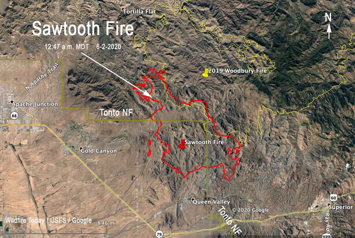
The Sawtooth Fire east of Phoenix 10 miles east of Apache Junction was not as active Monday as it was on Sunday. A fixed wing mapping flight at 12:47 a.m. MDT Tuesday determined that most of the growth was on the north side. When the incident management team releases an update Tuesday morning they are expected to say it has burned over 20,000 acres.
(To see all articles about the Sawtooth Fire on Wildfire Today, including the most recent, click here)
While firefighters faced 104 degrees Monday with 12 percent relative humidity, the wind was slight, about 2 to 5 mph which accounts for the less than massive spread Monday. The forecast for Tuesday calls for stronger winds out of the west at 5 to 10 mph, 13 to 18 percent RH, and a high temperature of 100 to 104. This could result in more fire activity than Monday on the south side of the fire north of Queen Valley and northwest of Superior.
At 12:47 a.m. Monday the Sawtooth Fire was approximately 2 miles north of Queen Valley and 8 miles northwest of Superior.
(UPDATED at 6:08 p.m. MDT June 1, 2020)

The incident management team on the Sawtooth Fire updated the size at 6:50 p.m. today, saying it has burned 16,000 acres. A Type 1 incident management team has been ordered — Sinclair’s team from the Southwest Geographic Area.
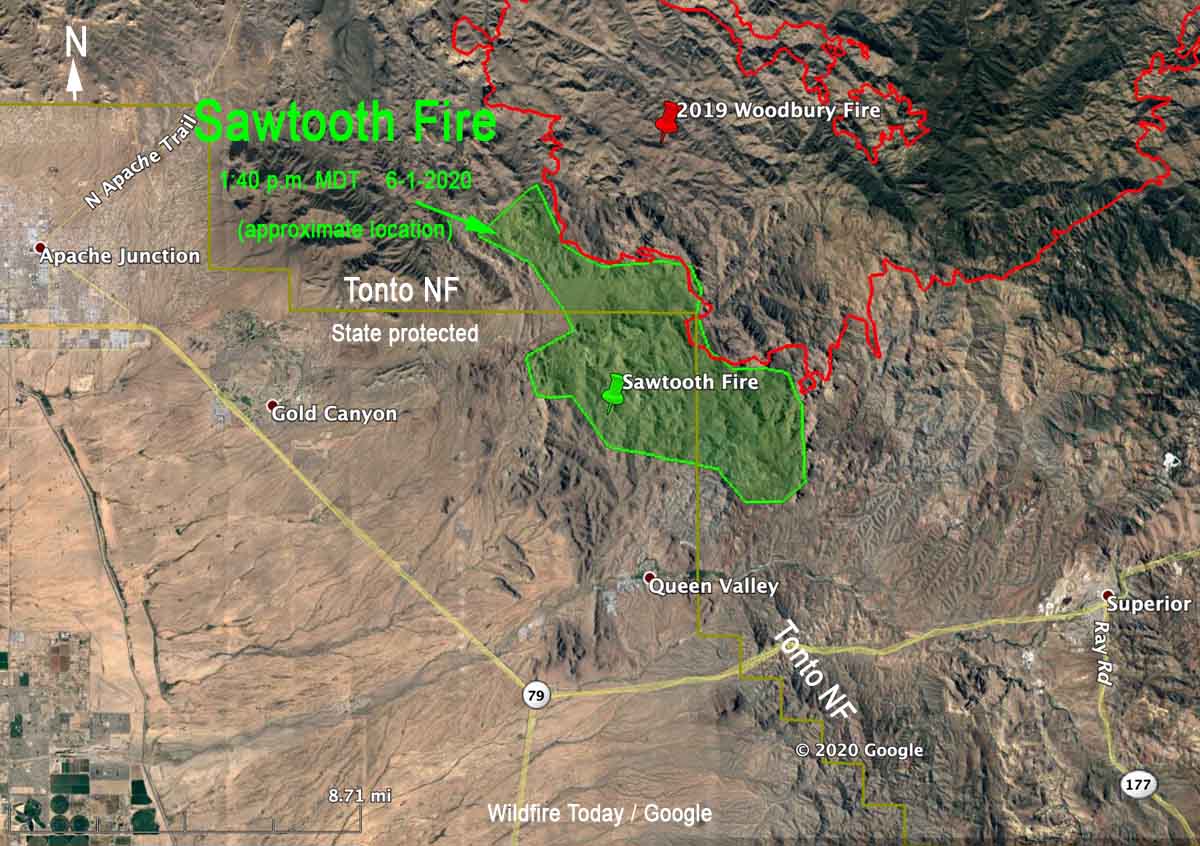
The updated map above shows the APPROXIMATE location of the Sawtooth Fire using satellite heat sensing data as of 1:40 p.m. Monday. The map includes the boundary of the Tonto National Forest (in yellow).
Most of the recent spread was on the northwest and south sides. It has grown about a mile closer to Queen Valley, and Monday at 2:30 p.m. was about two miles north of the community.
Very little official information is being released about this major wildfire.
(UPDATED at 8:20 a.m. MDT June 1, 2020)

The Sawtooth Fire east of Phoenix, Arizona was very active Sunday and Sunday night, spreading in all directions. It made a big push during the night growing three miles to the east and southeast.
(To see all articles about the Sawtooth Fire on Wildfire Today, including the most recent, click here)
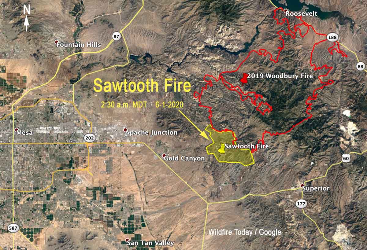
During a satellite overflight at 2:30 a.m. MDT Monday the fire was six miles east of Gold Canyon, three miles north of Queen Valley, and seven miles northwest of Superior.
The lightning-caused fire was reported Saturday at 10 p.m. It has burned into the footprint of the Woodbury Fire that blackened over 123,000 acres in June, 2019. Sunday night the Forest Service reported that the Sawtooth Fire was 3,500 acres. According to heat detected by satellites at 2:30 a.m. Monday it was approximately 11,000 acres. There has been limited spread into the Woodbury Fire scar.
The Sawtooth Fire is on land protected by the state and is also within the Superstition Wilderness area of the Tonto National Forest.
Weather
The low relative humidity Sunday at Gold Canyon was 10 percent and the high temperature was 112, falling to 78 by 5 a.m. Monday. The wind Sunday was not extreme, blowing at 3 to 8 mph with occasional gusts to 15, and less than that during the night. The direction was generally from the southwest, but switched to come out of the west-northwest after 10 p.m. and later the northeast, which accounts for the spread of the fire to the south detected by the satellite at 2:30 a.m.
The weather forecast for the fire area on Monday predicts a high of 99 to 103 degrees, a minimum humidity of 12 to 17 percent, and 5 to 8 mph upslope winds in the afternoon with isolated gusts to 12. There’s no chance of rain.

Thank you, Firefighters ?
This fire is FULL SUPPRESSION STRATEGY. 2 VLATS and 4 LATS last I checked at 1700 hrs. Right now the state has multiple fires burning. These guys are using everything they have in the area. 2 tankers from New Mexico were here too. Where homes are threatened that will be the priority first. This is rough country where hand crews can’t get in close. As a firefighter myself, I know they’re doing all they can. Please don’t go out and buy up all the toilet paper again.
It is amazing to me that the balance of the fire fighting takes place in Scottsdale, Cave Creek. Never mind the Superstitions burning, again. Out if control, again. We have yet to hear or see any bombers on this, yet I see photos on TV of bombers at Cave Creek. Those houses are already burnt, I hope Queen Valley is not next. I feel so bad for the animals in the area. Very sad.
My husband was a Fire Management Officer for years after 4 years of being a hot shot throughout the US out of northern Idaho. He wants to come dig fire line for you. He is 70 years old, but wants to do it!!
Lots of bombers were out over Sawtooth yesterday and a couple today.
Been watching them on my flight tracker.
Air Tankers and helicopters have been flying on the fire all day. There is a new fire to the south that is pulling air resources also. All of these desert fires are burning through the retardant and getting big quickly.
Any attempts at containment? Is the state going to let it burn out of control like they did the Woodbury fire? So sad that our state is being destroyed because we lack a proactive and responsive fire fighting team (s). ☹️
– The fire is a Forest Service fire. It is under full suppression strategy.
Sawtooth
USFS – Tonto National Forest. Started 05/30/20. Cause: Lightning/Natural
Peralta Road – Near Peralta Trailhead.
Initial ICS-209: 5/31/2020-21:37
3500 acres – Tall Grass (2.5 feet)
Strategy is 100% Full Suppression .
Currently 0% contained. Anticipate containment .
Active fire behavior (Short Crown Runs).
Projected Activity: estimated – 5000 acres – spreading toward queen valley and SE to Woodbury TH
Structures Threatened: None; Damaged: None; Destroyed: None
IR Flight: None
Critical Resource Needs: None
Notes: Threats to private inholdings.
Type 3 IC – Jim King
With the precipitation we had this year has resulted in a bumper crop of fine fuels. Hot dry windy conditions, you are not going to be able to keep all the fires small. The fires happening now are typical of desert fires when the conditions are ripe.
About half the fire is on state-protected land. The rest is on National Forest.
They’ve been ordering type one Crews and Had air tankers but they ran out of retarded at the Mesa Gateway airport so they had to return to home base or are they flying out of Winslow right now.
Just a note that the Woodbury fire burned over 123000 acres. My husband reported the Sawtooth fire at 7:20 PM Saturday evening to the forest service.
Thanks. Fixed it.
We were at Roosevelt Lake when that lightning storm went through Saturday evening. Almost immediately I noticed an Orange bright hue directly over the Tonto National Monument around 6:45ish. My camp members didn’t believe me when I said it was a fire…… Here we are now….