Updated October 23, 2020 | 7:54 a.m. MDT
In a briefing Thursday evening the Incident Commander of the Type 1 Incident Management Team, Noel Livingston, said the 50,000 acres of additional growth of the East Troublesome Fire brought the size up to 170,000 acres.
He confirmed that a spot fire crossed the Continental Divide and became established on the east side of Rocky Mountain National Park on the northwest side of Mt. Wuh. The spot fire stopped spreading when the temperature dropped to 30 degrees and the relative humidity increased to 89 percent as moisture came in from the east with a change in wind direction. The limited mapping that was done around and through clouds Thursday night showed that it had burned about 1,400 acres. Firefighting resources from the Cameron Fire to the north are assisting with this spot fire which is about 7 miles west of Estes Park.
To see all articles on Wildfire Today about the East Troublesome Fire, including the most recent, click here.
Grand County Sheriff Brett Schroetlin, who called the fire the “worst of the worst,” said Thursday morning there was “lots of structure loss,” but didn’t have details on how many had burned.
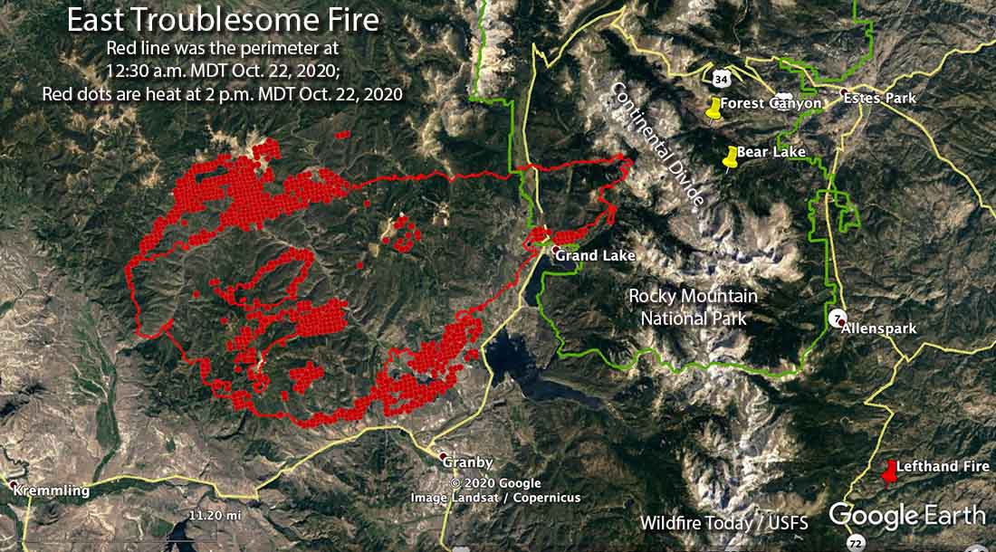
You can zoom in on the map above. The red line is the approximate perimeter of the East Troublesome Fire at 8:30 p.m. MDT October 22, 2020. However clouds over most of the fire partially blocked the view from the fixed wing aircraft that was mapping the fire. The white line was the perimeter at 12:30 a.m. MDT October 22, 2020. The red shaded areas represent intense heat, some of which is shown outside the perimeter line where clouds made it difficult to determine the perimeter.
Updated October 22, 2020 | 6:30 p.m. MDT
After reports of the East Troublesome Fire crossing the Continental Divide into the east side of Rocky Mountain National Park causing the evacuation of much of Estes Park, the community caught a break, however temporary it may be.
Paul Werth, Fire Weather Meteorologist, explained it in a comment below this article:
Good news for Estes Park! The first in a series of cold fronts has moved into the Estes Park area. Within the past few hours, the temperature at the Estes Park RAWS(NPS) has dropped to 30 degrees and the RH has jumped to 89%. The winds have also shifted from the SW gusting to 30 mph to an easterly direction of 10 mph or less. Weather stations a few miles to the west of Estes Park (elevation 8900 ft msl) also show cold temperatures and high RH with easterly winds. The high RH should moisten the 1 and 10-hr fuels to significantly diminish the threat of the fire moving into Estes Park.
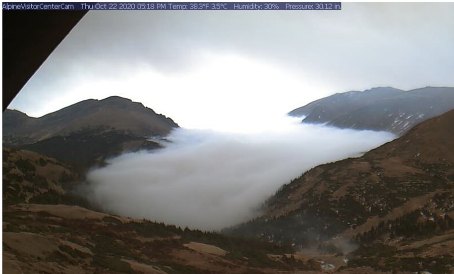
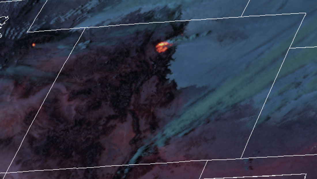
The satellite overflight at 2 p.m. Thursday did not detect any large heat sources east of the Continental Divide. This could be due to low clouds which blocked detection by the satellite’s sensors. Park employees were heard on the radio Thursday talking about smoke that was mixed with fog, and the GOES 16 satellite showed what appeared to be low clouds or fog east of the Divide, while smoke from the main fire to the west was blowing to the east over the clouds.
While there is a reduction in the fire activity east of the Divide, the rest of the fire was still active at 2 p.m. Thursday. In the Grand Lake area the wind shifted from coming out of the southwest, to coming from the south and south-southeast from 1 p.m. until 9 a.m. This allowed the activity on the north side to increase. As of 2 p.m. the fire had pushed to the north for about three miles to Parkview Mountain west of Highway 125. (see the map above)
The more moderate conditions in the Estes Park area are expected to last until Friday evening. There is even a 56 percent chance of precipitation in the area Thursday night. It could be back to the races again after 11 p.m. Friday with strong 17 mph winds out of the west gusting to 28 on Saturday, with the humidity in the 20s. Rain changing to snow is expected beginning Saturday evening.
West of the Continental Divide the winds will be moderate until picking up Friday afternoon, then becoming stronger Saturday — 20 mph out of the west gusting above 30 with the humidity in the 20s.
Updated October 22, 2020 | 2:44 p.m MDT
Updated October 22, 2020 | 1:06 p.m. MDT
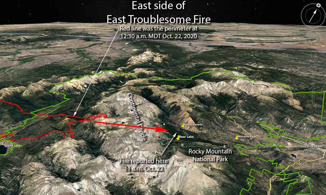
There are unofficial reports from individuals monitoring radio traffic that the East Troublesome Fire running to the east has jumped across the Continental Divide in Rocky Mountain National Park, which is 10,000 to 12,000 feet above sea level. Two of the locations that reportedly have fire is Bear Lake seven miles southwest of the town of Estes Park, and Forest Canyon which is west of Moraine Park.
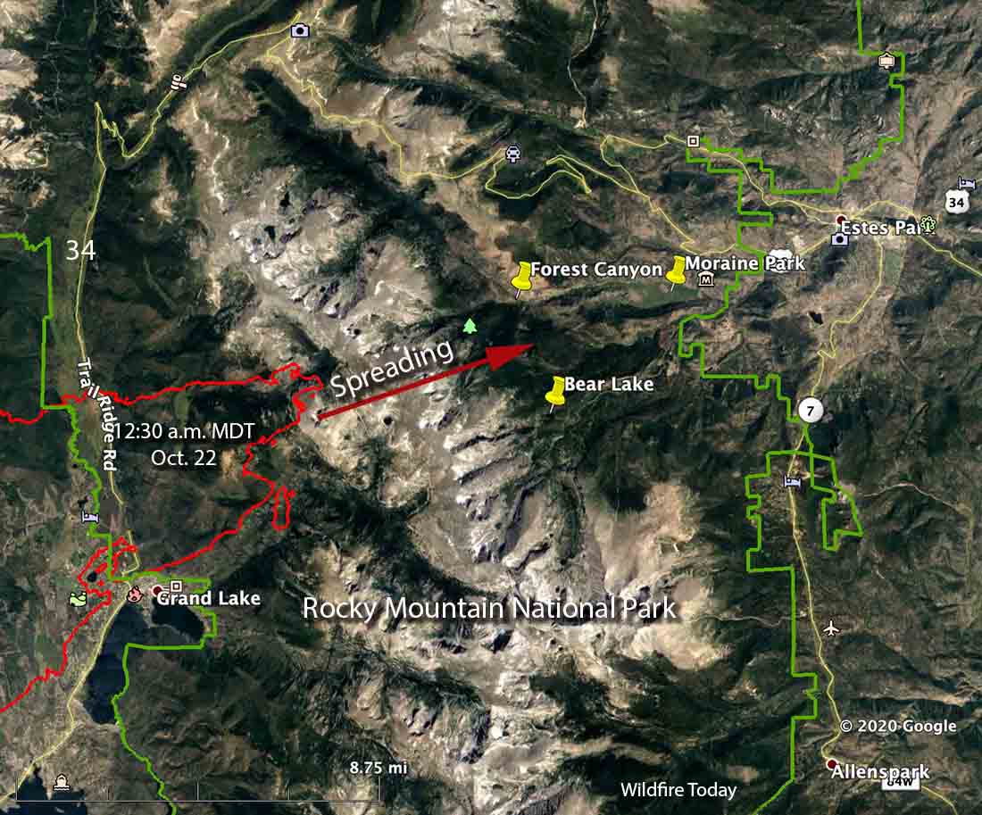
Mandatory evacuation has been ordered for parts of Estes Park with the following boundaries: north border of Fall River Road, south border of Highway 36, west border of Elm Road, and the east border of Wonderview. The Larimer County webpage with information about the Cameron Peak Fire now has evacuation updates, including a map, for the east side of the East Troublesome Fire.
Grandby is not under a mandatory evacuation order, as of 1 p.m. Thursday.
Rocky Mountain National Park is closed.
We will update this article as more information is available.
Updated October 22, 2020 | 8:03 a.m. MDT
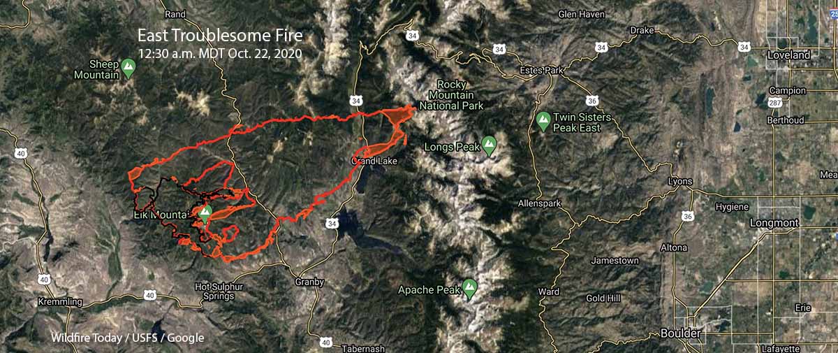
The East Troublesome Fire in Colorado grew six times larger Wednesday night. In a 28-hour period, from 8:55 p.m. October 20 to 12:30 a.m. October 22, it spread 19 miles increasing from 19,000 acres to 125,602 acres. (see the map above, and also the one below)
A mapping flight showed that it spread east across Highway 125, continued for 12 miles to Highway 34, and was last mapped 6 miles further east at the 12,000-foot mountains in Rocky Mountain National Park. At 12:30 a.m. Thursday it was about 10 miles west-southwest of Estes Park. The fire may have difficulty crossing the Continental Divide to get much closer to the town.
The community of Grand Lake on Highway 34 was impacted as well as areas west of Shadow Mountain Lake.
On the map below, you can zoom in and out.
When the fire was mapped Wednesday night the south side of the fire had not crossed Highway 40, remaining about one mile to the north. Overnight firefighters conducted a burning operation north of the highway, which was closed in the area at about 12:30 a.m. Thursday.
Evacuation orders and pre-evacuation notices are in effect. Current evacuation information can be found at gcemergency.com, and at the Facebook page of the Grand County Sheriff’s Department.
The weather forecast indicates the fire could continue rapid growth until snow begins Saturday evening. Strong winds out of the west-southwest and west are predicted gusting to 37 mph Thursday, 22 Friday, and 39 on Saturday along with relative humidities in the 20s.

Looks like the fire is headed towards the town of Grand Lake on the East End. Fire coming down the mnt. from the water tower, Youth Hostel rd. Any news on W Portal rd homes or intensity of this area?
Sorry but from an area where we don’t experience fires…Articles keep stressing that the fire has jumped the Continental Divide. Having traveled in the area I’ve seen what they’re talking about but not sure why that’s significant with a wildfire event. Trying to stay current and appreciate your site. My cousin evacuated yesterday from Granby.
Good news for Estes Park! The first in a series of cold fronts has moved into the Estes Park area. Within the past few hours, the temperature at the Estes Park RAWS(NPS) has dropped to 30 degrees and the RH has jumped to 89%. The winds have also shifted from the SW gusting to 30 mph to an easterly direction of 10 mph or less. Weather stations a few miles to the west of Estes Park (elevation 8900 ft msl) also show cold temperatures and high RH with easterly winds. The high RH should moisten the 1 and 10-hr fuels to significantly diminish the threat of the fire moving into Estes Park.
Thank you for the excellent information, Paul. I quoted you in an update to the article above.
(Paul is a Fire Weather Meteorologist)
Prayers for everyone fighting these fires ?
Prayers that everyone evacuates to safer areas?
Thank you for this website and updates?
Yes.
What is the difference between heat perimeter and intense heat on the map boundaries?
The fire is mapped by sensors on an aircraft that detect heat. The extent of the heat is within the perimeter. Not all of it was intense during the mapping flight. The areas that were, are identified. Generally, the areas with intense heat were more likely to have been spreading when the fire was mapped.
Very sad state of affairs when the weather prediction called for these winds. They had a total of 295 FF’s on it before this massive spread took place ! Shameful !
Shameful? How many people do you think are around to fight this fire?
Sorry Dusty, but the FS has the ENTIRE COUNTRY to draw from ! The weather three days ago Called for this Red Flag event but no they relied on the locals to help them out when it hit the fan ! Just not many of them around in a rural county to help. 295 FF’s for 19000 acres, come on , just a little unstaffed by any account. Now it’s crested the continental divide and headed for more towns.
It’s October. Many federal firefighters were laid off for the season several weeks ago. There are 34 other large fires in the US currently, and those also need to be staffed. Fire personnel can’t magically appear at a moment’s notice.
Jim, You must not understand how the forest service works. Just about every hotshot crew, engine crew, helitack crew, smokejumpers and anyone else that is hired as a seasonal employee is timed out. If you look at all the crews available right now there are very few with the exception of contract crews from the West coast. There just aren’t enough permanent employees in the forest service to staff year round. The seasons are getting longer and longer and the work force is getting smaller and smaller. Not to mention you have the Cameron Peak fire to the North that has been struggling to get resources. If your a Colorado resident please tell me the last time we had these types of fires in mid October. We haven’t and it wouldn’t matter how many people you had out there with the terrain and personnel on the ground when the weather and fuels dictate what the fire is going to do. Tankers and helicopters couldn’t fly due to the winds, which wouldn’t have mattered anyway because the fire would have blown through anything we would have been able to put down. So, if you think the forest service has so many resources to draw from, which we don’t please contact your local congress man or women and advocate for a permanent, year round and fully funded firefighter series for the forest service.
Thank you fire losing this to those that might not know. My husband just came off the August Fire, previously working the Dolan Fire. He said just this, many have timed out their 6-mos seasonal service. Some IMTs (incident management teams) after working nonstop for the past 6 mos, are taking a much needed 2 week break. We no longer have Fire seasons, but fire events. Resources are very, very thin. He told my family tonight, when they asked, what to do? He said, pray for cooler temps, and snow.
(And I’m thinking of S CA, where the Santa Ana’s haven’t even started yet.)
Entire country? There’s 5 hotshot crews on right now. We have an engine with one captain and we have enough employees to maybe staff it. Not sure where you think people are going to come from when most of the workforce has been laid off by this time of year.
Did it burn through NPS housing?
Where is that?
Not 100% sure. I have been to one near the VC – east side of US 34. I did read on an NPS employee site some housing was lost but no details.