Frank Carroll stirs up Lake Tahoe

“The Forest Service has no authority to let fires burn millions of acres — misappropriating tax dollars and recklessly destroying our natural resources. It’s an inverse condemnation of private property and wanton destruction of public resources, pure and simple.” ~ Frank Carroll

Agitator Frank Carroll, whom Dana Tibbitts with the Nevada Globe refers to as a “Chief Forester,” is an active part of this “discussion” in the Tahoe Basin and in New Mexico and other states, advising forest owners who hire him and assisting people in suing the Forest Service over losses resulting from escaped prescribed fires or managed fires that burned more acreage than Carroll thinks they should have. In her report, Tibbitts quotes anonymous sources to claim that FS Chief Randy Moore’s “Burn Back Better” letter (the annual fire-related “letter of intent”) has “caused a firestorm among firefighters and Forest Service veterans nationwide.”

Some of Tibbitts’ anonymous sources are associated with the “National Wildfire Institute,” founded by Bruce Courtright (retired FS Deputy Chief for Management Improvement) and Michael Rains — who at one time directed the USFS Forest Products Lab. Char Miller in the Los Angeles Times refers to the group as “a suppression-friendly bloc of retired Forest Service officials,” but they don’t seem to have a website or any publicly visible managers or founders besides Rains and Courtright.

Some other more widely respected retired fire experts disagree, and they’ve written here before on this topic, citing the founder of the U.S. Forest Service Gifford Pinchot. “The debate within the agency defies permanent resolution,” writes Char Miller,”not least because deference to political exigencies is baked into the Forest Service’s DNA. For that, we can thank, or blame, Pinchot.”

Miller is a senior fellow of the Pinchot Institute for Conservation, and a fellow with the Forest History Society. “In an 1899 article in National Geographic,” he explains, “Pinchot clearly detailed wildfire’s essential role in regenerating forests in the South and mountainous West. But despite this robust ecological evidence, it would be fire’s bad optics that drove his pitch for establishing the Forest Service.” As per the agency’s first manual: “Probably the greatest single benefit derived by the community and the nation from forest reserves is insurance against destruction of property, timber resources, and water supply by fire.”

Opinion: The burning debate — manage forest fires or suppress them?

Carroll and his cohorts, though, claim that the USFS “just gave firefighters license to burn millions of acres of forest and rangelands with zero commitment to putting the fires out.”

Tahoe-Douglas Fire Chief and head of the Northern Nevada Fire Chiefs Association Scott Lindgren said, “The latest forecast and guidance from the Chief is so unhinged from firefighting realities on the ground as to defy rational analysis or practical guidance.”

“It’s caused a firestorm among firefighters and Forest Service veterans nationwide.”  ~ Dana Tibbitts

Fire Chief Scott Lindgren, Tahoe Douglas Fire Protection District

According to Tibbitts and the Nevada Globe, USFS Regional Foresters are supposedly enacting a new policy now, calling for all fires in the Tahoe Basin to be risk-assessed and monitored by those same Regional Foresters, “who alone would determine the appropriate response to new fire ignitions.”

Chief Lindgren says allowing fires to burn is criminal and claims that allowing fires to burn means the USFS can count those acres as “treated” in burn quotas ordained by administrators in Washington DC. “These are not treated acres,” he says, “they are destroyed acres!”

Frank Carroll says USFS fire commanders and administrators are using firefighter safety as a false flag to justify wildfire use, even at the expense of civilian lives and devastated communities.

“Firefighter safety is an excuse that is neither safe nor supportable — a feature of the persistent failure to build informed consent and to analyze environmental impacts before letting wildfires burn and then expand them on purpose,” Carroll said. “They’re unilaterally implementing giant prescribed wildfires — consequences be damned.”

According to the anti-managed-fire crowd, the Biden-Harris administration’s plan to Burn Back Better is detailed in Confronting the Wildfire Crisis and lays out a 10-year program to treat 20 million acres of National Forest System lands and 30 million acres of other federal, state, tribal, and private lands. Randy Moore Letter of Intent 04/24/24

Randy Moore Letter of Intent 04/24/24 — click to read

Forest Service Chief says wildfires will be suppressed, rather than “managed”, for now

Temporary shift in policy due to extreme wildfire conditions in the West and competition for firefighting resources due in part to COVID-19 infections rising again

1:55 p.m. MDT August 3, 2021

Cub Creek 2 Fire
Cub Creek 2 Fire in Northern Washington, July 25, 2021. InciWeb.

In an August 2 letter to the field, new US Forest Service Chief Randy Moore said that because there is in a “national crisis”, they will not “manage fires for resource benefit”. In other words, instead of allowing fires to burn in order to replicate natural conditions and improve the ecosystem, they will put them out — at least to the best of their ability.

This year there are several factors that brought us to the crisis: competition for firefighting resources, a large number of incidents, firefighter numbers reduced by COVID-19 infections, and fire behavior enhanced by drought. It has all led to larger, longer-duration fires. Not mentioned by the Chief is the hundreds of vacant Forestry Technician positions. In early July there were 800 on National Forests in California alone.

During a virtual meeting July 27 with Western Governors to discuss wildfire preparedness, President Joe Biden was told that their states need more aviation resources, they need help with obtaining aviation fuel, they need more boots on the ground, and they encourage aggressive initial attack. The last item was referring to managing rather than suppressing fires. Governor Gavin Newsom referenced last month’s Tamarack Fire south of Lake Tahoe that was monitored but not suppressed. It stayed very small for 12 days until it grew rapidly, spreading east for 20 miles into Nevada, burning more than 68,000 acres and destroying 25 structures. On the August 3 National Situation Report it is still listed as a less than full suppression fire.

In declaring what is a temporary shift in policy until the Western fire season abates, Chief Moore cited numerous reasons for the change:

The 2021 fire year is different from any before. On July 14, 2021, the National Multi-Agency Coordination Group raised the national preparedness level (PL) to 5, the earliest point in a decade and the third earliest ever. There are currently over 70 large fires burning across the nation and 22,000 personnel responding, which are both nearly three times more than the 10-year average for the month of July. Severe drought is affecting over 70 percent of the West, and the potential for significant fire activity is predicted to be above normal into October. Our firefighters are fatigued, especially after more than a year of almost constant deployments, beginning with helping Australia in January 2020, and continuing through a difficult 2020 fire year and then supporting the vaccination effort in early 2021. In addition, COVID-19 infections are rising again. They are degrading our firefighting response capacity at an alarming rate, which will persist until more Americans are vaccinated.

In short, we are in a national crisis. At times like these, we must anchor to our core values, particularly safety. In PL 5, the reality is we are resource limited. The core tenet of the Forest Service’s fire response strategy is public and firefighter safety above all else. The current situation demands that we commit our fire resources only in instances where they have a high probability of success and they can operate safely and effectively. We will rely on the tested principles of risk management in determining our strategies and tactics.

Chief Moore said this was not a return to the “10 a.m. Policy” from 1935 which set as a goal stopping the spread of every fire by 10 a.m. the second day.

In addition, ignited prescribed fire operations will be considered only in geographic areas at or below Preparedness Level 2 and only with the approval of the Regional Forester after consulting with the Chief’s Office.

This directive only applies to the US Forest Service, and not to the four land management agencies in the Department of the Interior — National Park Service, Fish and Wildlife Service, Bureau of Indian Affairs, and Bureau of Land Management. Of those four DOI agencies, only the NPS is into “managed fire” in a big way. We asked a spokesperson for the NPS if they were making a similar temporary change in policy, but they were unable to meet our publication deadline, “given how busy it is and the need to work with the Washington Office of Communications”. [Update at 5:06 p.m. August 3. NPS Branch Chief for Communication and Education Tina Boehle got back to us with information which indicated the agency is not making any changes in their fire strategies — without actually stating it specifically.]

Currently there is a less than full suppression fire burning in North Cascades National Park in Washington which has blackened 150 acres, and another that has burned 470 acres in Yosemite NP in California. There are 18 listed on the Situation Report on National Forests, with most of them being in the Northern Rockies Geographic Area.

A video produced by the Northern Rockies Fire Science Network posted on YouTube last year was intended to spark discussion about managing fire for resource benefit on public lands. It featured interviews with 22 fire practitioners, including Dick Bahr, National Park Service Program Lead for Fire Science and Ecology, who said:

We have really good modeling now. … If you’re not comfortable with where it’s going to get or you’re concerned about what it’s going to burn up — do you take on the fire, or do you take on protection of what you’re going to do? And now the big shift is, we have now the opportunity, go put the money and the effort into protecting that point you’re worried about losing and let the fire do what it’s supposed to do…

You’re going to win a few, you’re going to lose a few. And it’s OK to lose, but you’ve got to learn from them.

Edited at 5:06 p.m. MDT August 3 to include late arriving information from the NPS which indicated that the agency is not making any changes in their fire strategies.

Washington Governor, “Everything we need to fight forest fires is in dire need across the Western United States”

Multiple governors asked President Biden for aerial assets, firefighters, help in obtaining aviation fuel, and aggressive initial attack

Air resources on the Cedar Creek Fire
Aviation resources on the Cedar Creek Fire in Washington, July 29, 2021. InciWeb.

Friday President Biden hosted his second virtual meeting to discuss wildfire preparedness. This session was with the Governors of three western states, Montana, Washington, and California. The earlier meeting on the topic was June 22, 2021.

The Governors told Mr. Biden that their states need more aviation resources, they need help with obtaining aviation fuel, they need more boots on the ground, and they encourage aggressive initial attack.

“Everything we need to fight forest fires is in dire need across the Western United States,” said Governor Jay Inslee of Washington.

These requests, coming from multiple states in late July with the meat of the fire season still possibly on the horizon, are astonishing.

The President began the meeting with a few remarks before asking the three Governors what the Federal government could do to help.

“Our resources are already being stretched to keep up,” Mr. Biden said.  “We need more help, particularly when we also factor in the additional nationwide challenges of pandemic-related supply chain disruptions and our ongoing efforts to fight COVID. We’ve had a few COVID clusters at our fire camps, which further limits resources.  It’s just one more reason why it’s so darn important that everyone get vaccinated, I might add. Sadly, we’ve also lost two brave firefighters in the last month in a plane crash in Arizona, and five were seriously injured last week battling the Devil’s Creek fire in Montana. It’s — to state the obvious, and you governors know it better than anybody — it is really, really dangerous work, and it takes incredible bravery to do it.  And these heroes deserve to be paid — and paid well — for their work.  That’s why, last month, I was able to announce — and it’s not paying that well, in my view, to be honest with you — immediate action to make all federal firefighters making at least $15 an hour.  I think they deserve more than that. We’re also working with Congress to make sure that our firefighters are paid better permanently.  Permanently.”

Governor Greg Gianforte of Montana was called on first. He spoke briefly, saying that aggressive initial attack was important. “Without that commitment,”Governor Gianforte said,  “we would have had many more large scale fires. And we ask that our federal partners join us in applying this operating principle. Whether it’s a fire that starts on private, state, or federal land — fires are easier to manage when they’re smaller.”

Governor Gianforte then went on to talk about active forest management.

Below are quotes from the other two Governors.

Governor Jay Inslee, Washington

My biggest concern might surprise you because all of the governors share these immediate concerns.  We have a huge need for additional aerial assets, additional dozer bosses so we can get our dozers into fire lines.  We need new tra- — more trained people.  We do have an emerging concern about our fuel supply for our aerial assets.  Everything we need to fight forest fires is in dire need across the Western United States, not just in Washington State.  We’ve had a thousand fires.  It’s burned four times more at this time of year than normal.  We’ve had two and a half times more acreage burn in the last decade than the previous.

Governor Gavin Newsom, California

Look, I just want to briefly — because there’s so many of us — a quick update.  We’re blowing past every record, and not in a good way.  We’re at over 5,700 fires year-to-date.  We suppressed 59 just yesterday with some initial attacks.  Over half a million acres already burned in California. To put in perspective — a record-breaking year.  Last year, we were at 130,000 acres burned.  We’re at 504,000 as I speak to you today.

Here’s the answer to your question.  And forgive me for being so pointed again, respecting your time, but I want to be a little bit more specific. Jay referenced it obliquely.  Please pay attention to this fuels issue.  We had to get our National Guard to get some emergency fuel supplies for our aerial fleet a week ago.  This is a major issue, and it’s not just impacting our aerial suppression strategies on the West Coast.  It’s increasingly, as you may know, impacting commercial aviation.  It is a major issue.

Number two, we just simply need more boots on the ground.  We can’t do without you.  We’ve got 7,400 people — 7,400 already.  We’re not in fire season.  Fire season in California is late September, October, into November.  We’re in July.  We already have 7,400 personnel actively working to suppress fires. Last year, the federal government asked us for over 5,000 mutual aid support that we could not provide.  That gives you a sense of what the federal government wanted from California last year to send to other states.  That should give you a sense of how far behind we are with federal support.

We have four DC-10s, Mr. President.  Four.  Now, DC-10s aren’t the answer to every problem.  They don’t fly over 35 knots.  They have restrictions; there are legendary restrictions.  But the reality is there is four for the country, and we’re competing.  They’re all contracted.  We compete with you.  We compete with other states.  We don’t even have access right now to DC-10s. We lost that 747 — that iconic 747 — that now has been converted to a cargo plane.  You’ve seen that in Australia, not just across the West Coast.  That’s now been grounded by a private contractor.

We are the largest civil aviation fleet for firefighting in the world — California.  We do not come close to having the tools in the air that we need.  We need your support to su- — to dramatically increase the aerial support, in addition to boots on the ground.

But here’s the final thing, and it’s the elephant in the room.  I was with Governor Sisolak two days ago in his state of Nevada.  The reason why is we had a fire that was on federal property.  Fifty-seven percent of the forest property in California is federal, just three percent under California jurisdiction.  Three percent.  Fifty-seven percent under U.S. Forest Service.  U.S. Forest Service is spectacular.  We have deep admiration and respect, but there’s a culture that, too often, is, “Wait and see.”  We can’t afford that any longer.  This was a federal fire.  They waited.  And what we saw is the fire took off because we didn’t put enough initial assets.

Greg was making an oblique point here.  I want to be a little bit more explicit: We need your help to change the culture, in terms of the suppression strategies, in this climate, literally and figuratively, to be more aggressive on these federal fires. That fire bled into Nevada and, obviously, impacted not just our two states, but deeply impacted the redundancy of this concern that comes out every year around jurisdictions and incident command and the imperative that we’re all on the same page, in terms of those initial attack strategies.

Tamarack Fire lifts evacuation orders for nearly 2,000 residents

The fire 15 miles southeast of South Lake Tahoe has burned more than 67,000 acres in California and Nevada

10:32 a.m. PDT July 26, 2021

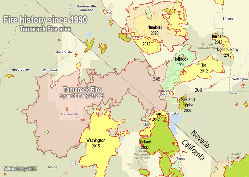
Fire history, Tamarack Fire
Map showing the perimeter of the Tamarack Fire July 25, and the history of fires in the area since 1990.

Law enforcement authorities in Alpine and Douglas Counties ended evacuations Sunday in 15 communities near the Tamarack Fire 15 miles southeast of South Lake Tahoe, enabling nearly 2,000 residents to return to their homes. The number of people still under evacuation orders is now approximately 300. A map is available showing the current status of evacuations.

The fire has burned 67,764 acres.

Monday morning authorities reopened Highway 395 on the east side of the fire and Highway 88 on the west.

The fire history map above shows that the Tamarack Fire burned into the footprints of multiple fires from previous years, including Washington (2015), Slinkard (2017), Holbrook (1994), and possibly Tre (2012). Not shown on the map is the East Fork Fire that burned in the notch in the perimeter east of Woodfords a few weeks before the Tamarack Fire. Depending on the vegetation type and the recency of the earlier burn, a new fire will usually slow down when it encounters a fire footprint, exhibiting less resistance to control. If it is not too windy, a combination of aerial and ground-based firefighters can often be effective in slowing or stopping the spread in those areas.

Tamarack fire
Tamarack fire July 25, 2021. The brown areas represent evacuation zones. Map produced by the fire Incident Management Team. Accessed at 9:30 a.m. PDT July 26, 2021.

The National Situation Report indicates that 15 structures have burned. A map is available showing the location of destroyed and damaged structures.

Hand crews were able to complete containment of the northern edge and several other critical locations on the fire Sunday. Monday’s priorities include finishing containment on the northeast corner and securing more of the southern edge.

Thunderstorms are in the forecast Monday afternoon, and there is a chance for rain into the evening.

Southeast side of Tamarack Fire
Southeast side of Tamarack Fire July 25, 2021. InciWeb.

Tamarack Fire spreads east across Hwy. 395 in Nevada

Burns more than 65,000 acres

12:26 p.m. PDT July 24, 2021

Tamarack Fire map
Tamarack Fire map. The white line was the fire perimeter at 9:30 p.m. PDT July 23, 2021. The green line was the perimeter approximately 24 hours before. The red dots represent heat detected by a satellite at 4:00 a.m. PDT July 24, 2021.

Calmer winds Friday allowed firefighters on the 65,152-acre Tamarack Fire 14 miles southeast of South Lake Tahoe to make progress, especially on the north and northeast sides of the fire. On Saturday they are expecting similar conditions which should allow additional containment efforts.

The Incident Management Team recorded a very informative video Saturday morning, featuring Operations Section Chief Pat Seekins.

Tamarack Fire
Tamarack Fire July 23, 2021. InciWeb.

1:40 p.m. PDT July 23, 2021

Tamarack Fire map
Tamarack Fire map. The white line was the perimeter at 7:25 p.m. PDT July 22, 2021. The green line was the perimeter about 24 hours before.

On Thursday the Tamarack Fire, pushed by strong winds, spread east across US Highway 395 in spite of firefighters’ best efforts to stop it at the highway with a burning operation. Within a few hours it burned about 2,500 acres east of the highway, becoming well established on that side.

On Tuesday the fire burned from California into Nevada. A mapping flight at 7:25 p.m. Thursday determined it had grown by about 7,000 acres to a total of 58,417 acres.

It crossed 395 a mile or two north of Holbrook Junction, which is the intersection with Highway 208. Friday afternoon the FlightRadar24 service showed a great deal of air tanker activity southeast of the junction. That would indicate that the fire had spread into the area between 208 and Topaz Lake, but it remains to be confirmed.

There are 1,353 personnel working on the fire and more resources are on order. Firefighting operations continue around the clock, with additional crews added to the night shift. Night operations include structure protection and firing operations when conditions are suitable.

Firefighters have continued to keep the fire south of Highway 88, which with Highway 89 were both closed in the fire area Friday morning to all traffic except incident personnel. A portion of 395 was also closed Friday morning for firefighter and public safety.

On Thursday an additional 1,369 people were evacuated primarily from the Hwy 395 corridor, bringing the total number of those evacuated to 2,439.

The Incident Management Team has created an interactive map that is intended to have evacuation information for residents.

Incident Management Team releases information about the origin of the Tamarack Fire

The fire crossed US Highway 395 Thursday afternoon

9:10 p.m. PDT July 22, 2021

Tamarack Fire map
Map of the Tamarack Fire July 22, 2021 before it burned across Hwy. 395. The time the data was current is not certain, but may have been early afternoon PDT July 22, 2021.

On Tuesday the Tamarack Fire burned from California into Nevada, and Thursday afternoon it made another big push to the east and hit US Highway 395 with some intensity north of Holbrook Junction. At first it was just a spot fire across the road but it grew very rapidly and at 4:10 p.m. aerial firefighters estimated it had burned 2,500 acres east of the highway.

Several large air tankers including a DC-10 Very Large Air Tanker assisted firefighters on the ground in an attempt to stop the spread of slopover across the highway.

Tamarack Fire crosses Hwy 395
Tamarack Fire crosses Hwy 395 in the afternoon of July 22, 2021. IMT photo.
Tamarack Fire
Tamarack Fire as seen from Hawkins Peak, looking ENE at 9:20 p.m. PDT July 22, 2021.

The Incident Management Team has created an interactive map that at some point is supposed to have evacuation information for residents.


2:32 p.m. July 21, 2021

Tamarack Fire
Tamarack Fire, looking northeast from Hawkins Peak at 2:17 p.m. PDT July 21, 2021.

The Incident Management Team that is suppressing the Tamarack Fire posted on InciWeb their view about how the fire was managed during the first 12 days after it started. The statement was presumably approved by the U.S. Forest Service, the jurisdiction responsible for suppressing and/or managing the fire which was on the Humboldt-Toiyabe National Forest.

“The Tamarack Fire on the Humboldt-Toiyabe National Forest was discovered on July 4,” the statement says. “At the time, 23 other lightning fires were burning.  It was a single tree burning in the Mokelumne Wilderness on a rocky ridgetop with sparse fuels and natural barriers to contain it. The steep, rugged, and remote terrain presented challenges to safely suppress this wilderness fire.  With several higher priority fires in the area and due to the remote location, the sparse fuels and natural barriers, and the concern for firefighter safety, the decision was made to monitor the Tamarack Fire.”

“The Tamarack Fire was monitored daily via air and fire cameras and exhibited very little fire behavior until Friday, July 16 when fueled by extreme winds and low humidity, it progressed rapidly downslope and spread throughout the evening. With this rapid change in the fire, fire resources were dispatched on Friday, July 16. Additional firefighting resources were also ordered, including very Large Air Tankers (VLAT), Single Engine Airtankers (SEATS) and helicopters.”

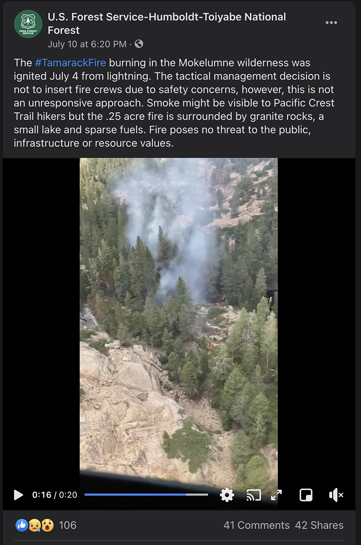
Below is a still image of a Forest Service Facebook post with a video of the fire when it was a quarter acre on July 10, six days after it started. “Fire poses no threat to the public, infrastructure, or resource values,” they wrote.

Tamarack Fire Facebook July 10, 2021

The Tamarack Fire spread further east on Tuesday, crossing the state line from California into Nevada. From its origin, it has now spread 15 miles northeast and 10 miles to the north, burning 10 structures and approximately 40,000 acres.

To see all articles on Wildfire Today about the Tamarack Fire, including the most recent, click HERE.