
It will be months before the NTSB releases a final report on the July 10 crash of an air attack aircraft in Arizona
Continue readingDo we have the luxury this year of not fully suppressing wildfires?
Allowing a fire to burn for months ties up valuable firefighting resources
Continue readingSnake River and Dry Gulch Fires very active in Washington and Idaho
8:30 a.m. MDT July 12, 2021
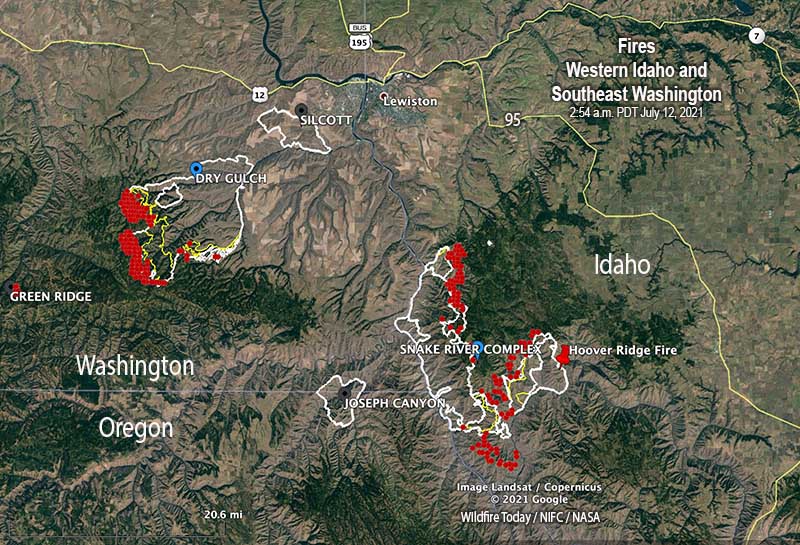
Wildfires are still very active where three states meet, Washington, Oregon, and Idaho.
Dry Gulch
Nearly all of the spread of the fire over the last two days has been on the southwest side. A mapping flight Sunday night found that it had grown to 55,050 acres, but has moved no closer to Lewiston, Idaho and is still 10 miles southwest of the city. The Dry Gulch Fire merged with the Lick Creek Fire on July 8 and they are now treated as one — Dry Gulch.
On Sunday evacuation warnings ( Level 2, get set) were in effect, but no actual evacuation orders (Level 3, leave now). (Very Brief Editorial: We need a national system of evacuation criteria that is uniform across the country, makes sense, and does not require training or explanation!)

The Dry Gulch Fire has been managed by a Type 2 Incident Management Team, but a Type 1 Team will assume command Monday, July 12.
Resources assigned on Sunday evening included 14 hand crews, no helicopters, 52 fire engines, and 4 dozers for a total of 536 personnel.
Snake River Complex
The 54,407-acre fire 12 miles south of Lewiston, Idaho is being managed by a Type 2 Incident Management Team. It is comprised of three fires that burned together, Shovel Creek, Captain John Creek, and Hoover Ridge. The growth over the last two days has been closer to each other as well as to the east and the south. It is bordered on the west side by the Snake River. The greatest spread Sunday was on the south side where the Shovel Creek Fire came close to the Salmon River. The east side of the Hoover Ridge Fire is being held by the Salmon River.
Approximately 438 residences are threatened.
From the Incident Management Team Sunday evening:
On the north end of the fire, resources continue to protect values at risk including primary structures and infrastructure around Waha Lake and Red Bird road. Tactics include a combination of indirect line followed up with burning in Madden Creek and around to the south. In the Craig Mountain area, resources are completing indirect fireline to the north. The Hoover Ridge fire resources continue to secure the northeast corner down to the Salmon River. Resources are still using a point protection strategy to burn around and secure values at risk in both the Salmon and Snake Rivers.
Resources assigned Sunday evening included 3 hand crews, no helicopters, and 6 fire engines for a total of 170 personnel.
Dixie Fire
The 15,323-acre Dixie Fire just east of Dixie, Idaho is not being completely suppressed by the Nez Perce-Clearwater National Forest. It is being managed by a Type 1 Incident Management Team. Resources that are 15% monitoring, 30% confining, 35% point protecting, and 20% suppressing the fire include 8 hand crews, 16 fire engines, and 4 helicopters for a total of 522 personnel. The same team is managing the nearby 898-acre Jumbo Fire. (map)
The two aerial firefighters killed in July 10 aircraft crash in Arizona have been identified
5:20 p.m. MDT July 11, 2021

The Bureau of Land Management has released the names of the two men killed July 10 in the crash of an air attack aircraft in Arizona.
The incident occurred at about noon during initial attack efforts on the Cedar Basin Fire, which is 14 miles east of Wikieup in northwestern Arizona.
Pilot Matthew Miller, 48, and Air Tactical Group Supervisor Jeff Piechura, 62, were on board a Beechcraft King Air C-90 aircraft conducting visual reconnaissance and aviation command and control over the fire. Mr. Miller was a fire pilot with Falcon Executive Aviation, Inc. contracted by the U.S. Forest Service. Mr. Piechura was an employee with the Coronado National Forest. Their remains have been recovered from the accident site.
Often eyewitness accounts are wrong.
But, the Arizona Republic interviewed a woman who saw the aircraft from her home coming down at a “steep angle” and then “slam into the ground.” An hour later she and her husband drove to an area near the crash. They said Bureau of Land Management employees told them they they witnessed a wing fall off the plane in the air before it crashed.
We are aware of four other wildland fire related aircraft crashes in North America this year in a 46-day period, for a total of 7 fatalities:
- A helicopter went into Lake Shastina July 7 while working on the Lava Fire in Northern California. The pilot swam away.
- The pilot of a helicopter that crashed while fighting a fire in Alberta, Canada was killed when the Bell 212 went down June 28.
- A helicopter crashed and burned while working on the Deep Creek Canyon Fire in Montana June 15. Everyone walked away.
- Four were killed in the May 25 crash of a helicopter at Leesburg, Florida.
In 2020 during a 49-day period that began July 7 there were six crashes of firefighting aircraft — three helicopters and three air tankers. In addition, three members of the crew of a C-130 from the U.S. died when their air tanker crashed January 23, 2020 while fighting a bushfire in New South Wales, Australia.
The article was edited to show that there were no reported serious injuries in the June 15 helicopter crash.
Names released of the two killed July 10 in crash of air attack plane in Arizona
5 p.m. MDT July 11, 2021
 File photo, example of a King Air 90GTx. This is not the aircraft that crashed.
The Bureau of Land Management has released the names of the two men killed July 10 in the crash of an air attack aircraft in Arizona.
The incident occurred at about noon during initial attack efforts on the Cedar Basin Fire, which is 14 miles east of Wikieup in northwestern Arizona.
Pilot Matthew Miller, 48, and Air Tactical Group Supervisor Jeff Piechura, 62, were on board a Beechcraft King Air C-90 aircraft conducting visual reconnaissance and aviation command and control over the fire. Mr. Miller was a fire pilot with Falcon Executive Aviation, Inc. contracted by the U.S. Forest Service. Mr. Piechura was an employee with the Coronado National Forest. Their remains have been recovered from the accident site.
Often eyewitness accounts are wrong.
But, the Arizona Republic interviewed a woman who saw the aircraft from her home coming down at a “steep angle” and then “slam into the ground.” An hour later she and her husband drove to an area near the crash. They said Bureau of Land Management employees told them they they witnessed a wing fall off the plane in the air before it crashed.
We are aware of four other wildland fire related aircraft crashes in North America this year in a 46-day period, for a total of 7 fatalities:
- A helicopter went into Lake Shastina July 7 while working on the Lava Fire in Northern California. The pilot swam away.
- The pilot of a helicopter that crashed while fighting a fire in Alberta, Canada was killed when the Bell 212 went down June 28.
- A helicopter crashed and burned while working on the Deep Creek Canyon Fire in Montana June 15. Everyone walked away.
- Four were killed in the May 25 crash of a helicopter at Leesburg, Florida.
In 2020 during a 49-day period that began July 7 there were six crashes of firefighting aircraft — three helicopters and three air tankers. In addition, three members of the crew of a C-130 from the U.S. died when their air tanker crashed January 23, 2020 while fighting a bushfire in New South Wales, Australia.
Update at 8 a.m. MDT July 12, 2021
Below is the brief preliminary Accident Notification from the FAA, published July 12, 2021:

Smoke forecast July 11, 2021

This is the forecast for vertically integrated wildfire smoke at 5 p.m. MDT July 11, 2021.
Bootleg Fire in Oregon continues to spread east
By Sunday night it had burned more than 153,000 acres
Continue readingBeckwourth Complex fire crosses Hwy. 395, burns structures in Doyle, California
The Sugar Fire grew by more than 25,000 acres Saturday
Continue readingCrash of air attack aircraft in Arizona kills two aerial firefighters
14 miles northeast of Wikieup
Continue readingTwo aerial firefighters killed in crash of air attack aircraft in Arizona
43 miles southeast of Kingman
Continue reading