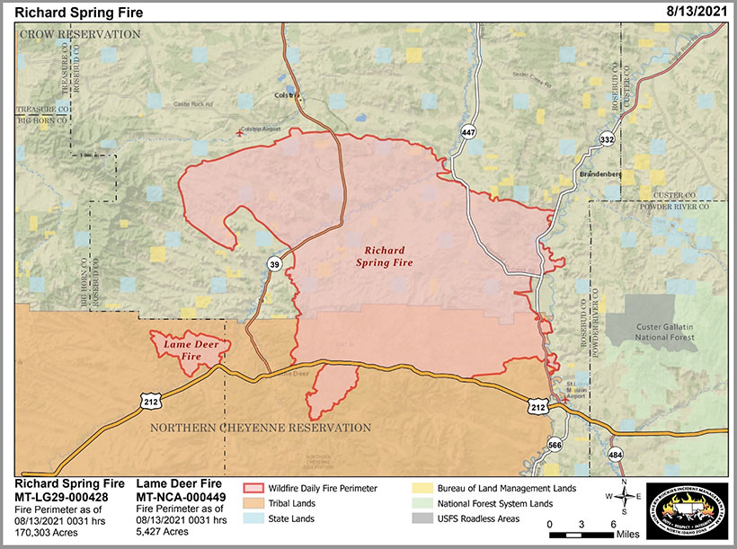
7:03 p.m. MDT August 13, 2021

The Richard Spring Fire reported August 8, 2021 10 miles southwest of Colstrip, Montana has burned along the Tongue River threatening multiple communities. It has been driven by strong winds through brush, short grass, and timber 90 miles east of Billings.
Evacuations are in effect for Lame Deer, Muddy Cluster, and Rosebud Cut Across.
Highway 212 is closed between Broadus and Crow Agency to all non-residents. Highway 39 is currently open, but this could change at any time.
The north side of the fire spread to the massive coal mines west of Colstrip. The south side, 12 miles to the south, jumped across US Highway 212 east of Lame Deer and has moved into heavier fuels. That is the area that showed the most activity in a 12:31 a.m. mapping flight Friday and is where many resources are currently concentrated.

Firefighters, including four Hotshot crews, are constructing hand line south of Highway 212 in an effort to contain the fire north of the Lame Deer Divide Road. Air tankers and helicopters are supporting the ground-based crews.
Lame Deer Fire
A fire 4 miles west of the Richard Spring Fire, the Lame Deer Fire, has burned 5,427 acres just north of Highway 212 and the community of Muddy. It is 3 miles west of Lame Deer. Firefighters took advantage of the precipitation to construct line and conduct burnout operations. Those efforts have been successful so far, and crews now have initial control lines constructed around most of the perimeter and will continue to strengthen those lines.

GOD BLESS the men and women who are out risking there safety and there LIVES to keep others safe .TRUE HERO’S ❣
Amen !