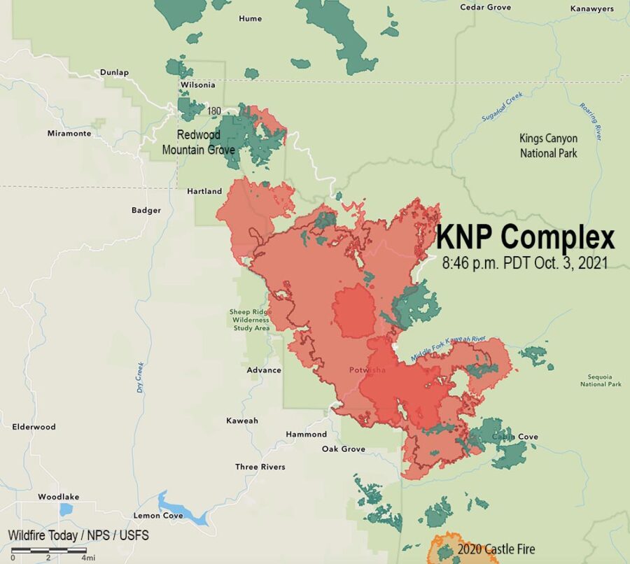
4:13 p.m. PDT October 4, 2021
The firing operation on the north side of the KNP Complex along the Generals Highway/180 southeast of Wilsonia is moving along rapidly. It appears to have begun on Saturday, and by the time of the mapping flight Sunday night had spread half a mile to a mile south of the highway. It is now moving through the Redwood Mountain Grove, which is the largest grove of giant sequoia (Sequoiadendron giganteum) trees on earth. It contains the world’s tallest giant sequoia, 312 feet (95 meters).
Monday morning @mn_storm reported that a very large pyrocumulus convection column of smoke had been created that rose to 33,000 feet where the temperature reached -62°F. Monday afternoon @mm_storm said another pyrocumulus had reached 40,000 feet.
Full-day visible satellite loop capturing both intense pyroconvective events so far on the #KNPComplex in the Southern Sierra. #CAwx #CAfire pic.twitter.com/Tos0J3649k
— US StormWatch (@US_Stormwatch) October 4, 2021
Nate Bogenschutz, an information officer for the fire, told Wildfire Today at 4 p.m. PDT Monday that the firing operation had remained within it’s intended boundaries and had not crossed Generals Highway/180. He said fire activity had increased around most of the fire today.
Our hope is that most of the smoke is not coming from the Redwood Mountain Grove and the tactical firing operation, and that the operation does not destroy large numbers of giant sequoia trees, which can live for more than 3,000 years old if climate change was not creating multi-year droughts and extremely low fuel moistures.
10:27 a.m. PDT Oct. 4, 2021

A drying trend over the last several days has led to an increase in fire behavior on the KNP Complex of fires in the Sequoia National Park in California. This has been especially apparent in lower elevations on the south and west sides where brush is the primary component of the vegetation.
Smoke trapped under an inversion has socked in the drainages and has limited the use of conventional aircraft for the last few days. However drones with infrared technology which can see through smoke have been flying, providing intelligence about the spread of the fire.

Two large firing operations are ongoing. On the north side near the Heartland community firefighters are working to keep the fire in Redwood Canyon, an area that is very steep and rugged all the way north to the Redwood Mountain Grove and the Generals Highway/180. The canyon is too steep and inaccessible and has multiple hazards, making it unsafe for firefighters. Saturday night a firing operation began at the highway to get the fire to back down the slope to the south, creating a buffer along the highway. By Sunday night fire personnel had ignited along four miles of the highway.
A few miles to the southeast, another firing operation is working north along the Generals Highway, starting near Dorst Campground. After it proceeds for a few miles, it will leave the highway to get onto a trail system to the west, closer to the fire, and will eventually meet up with the other operation which is working south off the highway.

The incident management team is having difficulty obtaining the firefighting resources they need. This is due to several reasons, including the fact that some seasonal employees on hand and engine crews are reaching the end of their employment periods, and other fires are competing for the same types of resources.
Sunday night strong winds on the south side of the fire caused a spot fire across Mineral King Road which prompted an evacuation order for Crest, Sierra King, Hammond, and Oak Grove. Evacuation details are available on a map and at the Tulare County Sheriff’s Facebook Page.


Here’s the thing, summarized by Royal Burnett: Many of the respondents on this thread are current and retired wildland firefighters. Some , like me have worked and fought fire in and around the King’s Canyon NP. We are protesting the policies and the management that allows these fires to burn on our federal lands. The firefighters are only following orders…but someone at some level sanctioned the burning of Redwood canyon with a cold front and associated wind approaching. There was no chance of holding that line…and the redwood groves in that canyon may not survive. We’ve lost a national treasure because someone at some level did not put the fire out.