
Updated 11:55 a.m. MDT May 11, 2022
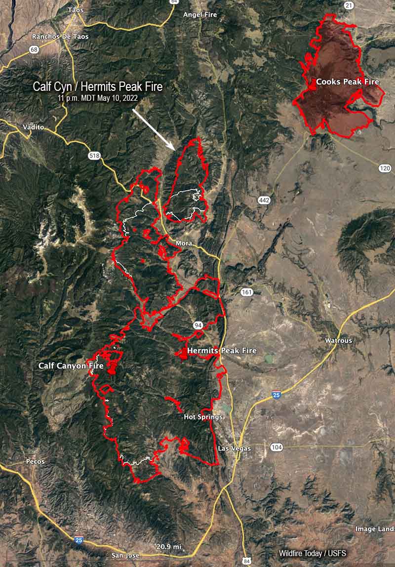
Calf Canyon / Hermits Peak Fire
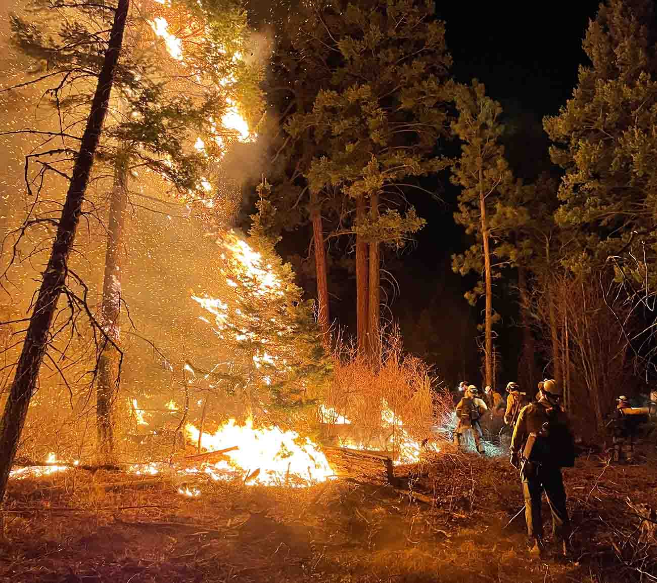
The Calf Canyon / Hermits Peak Fire made large runs on the north side Tuesday. The area that spotted over Highway 518 a couple of days ago east of Holman spread six miles farther north. Another slopover occurred Tuesday northwest of Holman and ran four miles to the north. When the fire was mapped at 11 p.m. Tuesday the fire had not spread east of the 434 road.
On the south end east of Barillas peak, an area that has been very active recently, it moved another two miles to the south.
Tuesday afternoon I briefly checked an aircraft tracking website and quite a few aircraft working the fire, thanks to a decrease in wind speeds and turbulence. At that time there were two large air tankers (MD-87s), one very large air tanker (DC-10), four scooping air tankers, at least two helicopters, as well as a lead plane and an air attack.
The blaze has now burned 236,939 acres, an increase of about 33,000 acres in 24 hours, and is now 13 miles southwest of the Cooks Peak Fire.
Cerro Pelado Fire
The map produced by an aircraft Tuesday night found incremental differences in the fire perimeter, but no large additional runs. Most of the changes were due to firefighters conducting tactical burning operations to tie in the fire’s edge to roads or other firelines.
The fire has burned 42,491 acres.
8:08 a.m. MDT May 10, 2022

The Calf Canyon / Hermits Peak Fire near Los Vegas, NM grew substantially in two areas Monday and had burned a total of 203,920 acres by evening. On the north side, the spot fire east of Highway 581 that was 200 acres Sunday night spread east for more than 5 miles and burned about 8,000 acres by Monday night. When the fire was mapped at 10:24 p.m. Monday firefighters were holding it at the 434 road.

On the southwest side 9 miles west of Las Vegas near the A18A road the blaze spread for another mile and a half to the south. Operations Section Chief Todd Abel said Monday evening that the fire in that area was still within contingency firelines that have been constructed further south. Hand crews and engines are in the area improving lines and protecting structures.
To see all articles on Wildfire Today about the Calf Canyon / Hermits Peak Fire, including the most recent, click here.
On Monday there were scattered areas on the west side of the fire that were very active late in the afternoon.
The very strong wind prevented air tankers from working Monday, but Mr. Abel was gratified that a small Air Attack plane was able to find an altitude without too much turbulence and was able to reconnoiter and provide information to personnel on the ground. At one point we saw on an aircraft tracking site that the aircraft was orbiting at 20,000 feet, much higher than their usual operating altitude.
The Cerro Pelado Fire 7 miles southwest of Los Alamos was active Monday on the northeast and southeast sides. It was mapped Monday night at 42,491 acres, an increase of about 1,500 acres, and still had not crossed Highway 4.

Nearly all of New Mexico is under a Red Flag Warning Tuesday due to strong winds and low humidity.

Common, NIFC, this fire is way beyond the capabilities of this type 1 team and type 2 team “that is not mentioned”, . There needs to be at least 4 teams on this since it is now headed towards “rich peoples houses or mansions from Texas”. With boots on the ground saying there is no leadership and people scattered for miles and miles it has gotten out of hand. I know this fire could be divided into 4 sections as of today. Nothing but dry fuels and high winds, why wait till the last minute to send more help. Yes the terrain is steep, high elevation, and people are tired. But if the FS really wanted to they could put a stop to this by concentrating on a few miles of fire instead of a hundred miles of land, by 1 person. What? yes conditions are extreme, that’s why this teams need to call for help instead of trying to it by themselves. How much will it cost the tax payers now, 2 billion, and counting? Don’t forget about the poor people.
Doesn’t matter how many IMT’s or CIMT’s you put on it, they’re only going to get so many people. With all the National staffing shortages Forests and BLM units are clamping down and going into “Tortoise Mode” by not letting the few people they do have go available. The few people left are being held for District IA because the fear of not being able to get a fill on resources if something breaks on the homefront. The staffing shortages are an absolute catastrophe!
The number of UTF’s is already at a staggering level and it’s only May…at a National PL2!!!!!
Who allowed or ordered this”prescribed “ burn?? Should be charged with involuntary manslaughter, destruction of homes, death of pets and livestock. Not only the animals, but that lost livestock was their way of earning a living. That person needs to be charged and prosecuted ….
Bill G. Is one of these fires an escaped RX? If so why is no one speaking to that, these incidents are now making the national news and no mention of an escape, I know that a fire is a fire no matter how it started, I just feel that folks should know, not at all trying to stir things up…..Thanks.
We have been covering this fire since April 9, and have reported the cause numerous times, but not in every article.
Hermits Peak was formerly known as Gallinas Rx.
Calf Canyon, well, it’s “under investigation” but all the FF’s on the ground (and air) know the actual cause because many of them IA’d it and noticed all these odd 1/2 burnt slash piles all over the place.
Bill is right, he’s been covering them both since their outsets. We received word today that Gallinas/Hermits will be subjected to a Cheifs level investigation.