While the Forest Supervisor of the Santa Fe National Forest, Debbie Cress, is temporarily assigned to the acting Deputy Chief of Staff position for the U.S. Forest Service in Washington, James Duran will serve as acting Supervisor for the next four months. This is occurring while the largest fire in the recorded history of New Mexico, the Hermits Peak / Calf Canyon Fire, is still not officially contained.
From the Associated Press:
Some have questioned the timing given that the wildfire has yet to be declared contained and recovery work has just begun.Forest officials have dismissed criticism, saying the opportunity for Cress to work at headquarters initially came up in January and was the culmination of her work over the past year with the agency’s leadership.
Cress acknowledged in a statement Friday that it was difficult timing as her home state deals with the aftermath of the massive wildfire.
Debbie Cress. USFS photo.
The 341,735-acre fire is the result of two prescribed fires on the Santa Fe National Forest that escaped control. One was a broadcast burn that crossed control lines during a strong wind. The other originated from slash piles that were ignited in late January that continued burning for months. In mid-April one or more of the piles became very active and began spreading and merged with the other escaped fire on April 22.
In 2018 another pile burning project on the Santa Fe escaped months after it was ignited and had to be converted to a wildfire. A Facilitated Learning Analysis found that “communication” and “prescribed fire preparation and risk” were common themes.
Ms. Cress began as the Forest Supervisor in April of 2021. Three months before, the Santa Fe New Mexican reported, she had transferred from a District Ranger position in Arizona to be the Deputy Forest Supervisor on the Santa Fe National Forest.
Thanks and a tip of the hat go out to Jim and Gerald.
More than 1,000 fire personnel were affected by inadequate communication with the Incident Command Post
File photo. A Radio Technician sets up a portable radio repeater on the Sprague Fire in Glacier National Park in Montana, September 16, 2017. NIFC photo.
The difficulties in hiring and retaining wildland firefighters which has resulted in one-third of the Forest Service firefighter positions in California being unfilled, may not be restricted to just those who directly battle the flames. The old axiom, “amateurs think strategy, generals think logistics,” does not only apply to the military. If firefighters can’t be supplied with food, water, vehicle maintenance, hose, tools, fuel, and communications they will not be successful in a long campaign.
The concept of firefighters ensuring that before they engage, they must have adequate Lookouts, Communications, Escape routes, and Safety zones (LCES) was developed by Paul Gleason. It is shorthand for combining a list of Standard Orders fire personnel must follow to protect themselves from fireline hazards such as being entrapped in the fire. According to a report on SAFENET, there was a four-day period from May 15 until May 19 when the Communications leg of LCES was not covered adequately on the Hermits Peak/Calf Canyon Fire in Northern New Mexico.
The National Situation report for May 15 shows that in the United States that day there were 10 large uncontained fires, with all of the fires in the country being staffed by a total of 4,708 personnel. When the fire season nears its peak this summer there could be five times that many people assigned to fires. But in the middle of May there was a shortage of radio technicians and radio operators which made it impossible to set up an adequate radio communications system when it was needed on the north zone of the fire following a reorganization.
I was told by mentors as I came up through the ranks that firefighting is not an emergency — not to firefighters. It’s what we do. So when the situation gets suddenly more complex and decisions must be made and executed quickly, think calmly, act decisively, and communicate clearly. At least one of these suddenly complex situations occurred on the fire. A person needed medical treatment and extraction by air. It is referred to in the SAFENET as an incident within an incident. They are usually managed separately by an offshoot organization, and they always require efficient, robust, dependable, instant communication.
The text below is taken word for word from the SAFENET. The only change we made was to translate the acronyms.
Narrative
When Southwest Team 1 took command of the North Zone of the Hermits Peak/Calf Canyon Fire communications were unable to be linked with Incident Command Post (ICP). The zoning of the incident required the current radio communications system to be split. The North Zone remained on the current system with the South Zone moving to their own system. During this transition there were no radio techs to switch the repeater link for the North Zone and install the repeater to cover ICP. For a duration of 4 days, the link with communications at the ICP was ineffective. This was highlighted on 5/17 with a red medical that required extraction by air. During the Incident Within an Incident (IWI) communication were not able to function from ICP to the field and back. As the fire progressed, the repeater that was required for ICP was also needed to cover field personnel. Approximately, 300 personnel in the field had limited communications, with the only link established through a human repeater. During high fire behavior periods, several resources were forced to abandon tactics and leave the line because communications could not be established. The contributing factor, is the lack of radio techs available nationally. Orders were placed for radio techs days before transition and after transition. Orders for one week were returned unable to fill (UTF). Furthermore, radio operators were also unavailable. Orders were also placed for CAT personnel which was also UTF. The lack of communications personnel resulted in decrease support for the field and inability to coordinate IWI response and transport through ICP and the communications unit. About 1,200 firefighters were affected by the lack of communications with ICP.
The lack of communication personnel is limiting the “C” in “Lookouts, Communications, Escape Routes, Safety Zones” (LCES) and needs to be resolved at the national level. The trend of unable to fill communications personnel has progressively gotten worse over the last few years and will most likely result in incidents without communications in the future.
Immediate Action Taken
Field personnel had communications on the most fireline through the existing repeater system. Approximately, 25% of fireline personnel had no communications coverage which was unsatisfactorily resolved with a human repeater during the 4 days without a radio tech. Field Operations was utilized to coordinate response and transport for IWIs placing their self in a location with cell service and radio service. A radio tech was sent from the South Zone once their system was installed and working. That individual then moved to the North Zone on Day 4 to begin configuring the North Zone communication system. On 5/20, 4 days after transition, the North Zone communication system was operating providing coverage for ICP and the incident.
Other mitigations for correcting the problem took considerable time to no avail and included contacting commercial vendors, national guard and state compact agreements. The solutions did not pan out. Currently, land management agency fire organizations have no capacity for implementing a communications system on an incident without reliance on personnel outside of the fire organization.
Occurred on the Calf Canyon/Hermits Peak Fire in New Mexico
Updated at 5:25 p.m. PDT June 7, 2022
A “72-hour preliminary report” dated June 6, 2022 shed a little additional light on the May 29 incident in which three firefighters were injured when struck by water dropped from a helicopter on the Calf Canyon-Hermits Peak Fire in New Mexico.
It adds that the hotshot crew was not injured directly by the water, but were knocked onto boulders by the force of the drop.
They were hit by the water “while they were crossing a steep rocky piece of ground, consisting of 2 to 3 foot diameter boulders. Three crewmembers were injured by falling in the rocks as a result of being impacted by the water drop” from a Type 1 helicopter.
The most seriously injured firefighter, who had multiple surgeries to repair facial fractures and a broken kneecap, was released from the hospital over the weekend and will be traveling home over the next several days, accompanied by family members and his crew supervisor.
A Facilitative Learning Analysis will be conducted “to share learning from unintended outcomes and to reduce the probability of future occurrences of similar events.”
3:08 p.m. PDT June 1, 2022
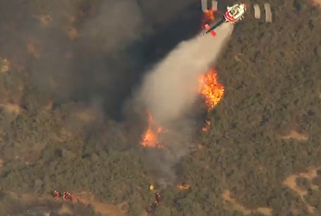
File photo of a helicopter dropping water in support of a hand crew that was attacking a spot fire at the Wildomar Fire in Southern California at 4:24 p.m. October 26, 2017. Screen grab from KTLA live video.
Three firefighters were injured, one seriously, May 29, 2022 while working on the Calf Canyon / Hermits Peak Fire in Northern New Mexico.
According to a 24-hour preliminary report dated today June 1, the Bureau of Land Management Vale Interagency Hotshot Crew was holding a section of fire line when a large Type 1 helicopter “missed the identified drop area” while attempting to drop water on the fire edge. The last of the load landed on several crew members, three of which were transported to a hospital in Santa Fe, NM, two by ground vehicle and the third by an agency helicopter.
One of them with severe injuries was later transferred to a hospital in Albuquerque where he has received multiple surgeries, one to repair skull fractures to the face, and the other to repair a broken knee cap. The employee is still in the hospital, accompanied by family and his crew supervisor.
The other two firefighters received injuries described as minor; they were treated and released.
Other than the specifications of the helicopter qualifying it as a Type 1 ship, no other description was given in the report. Type 1 helicopters can carry between 700 and 3,000 gallons, ranging from the 700-gallon K-MAX to a 3,000-gallon Chinook.
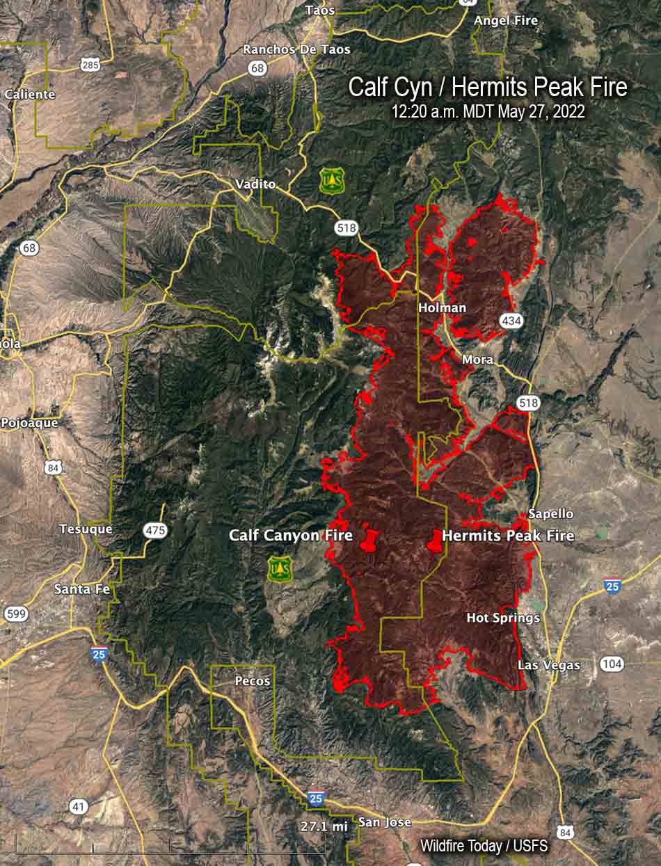
The Calf Canyon/Hermits Peak Fire in New Mexico started from two separate escaped prescribed fires which merged into one. It has burned more than 315,000 acres 20 to 47 miles east and northeast of Santa Fe.
It later merged with the Hermits Peak Fire northwest of Las Vegas, New Mexico
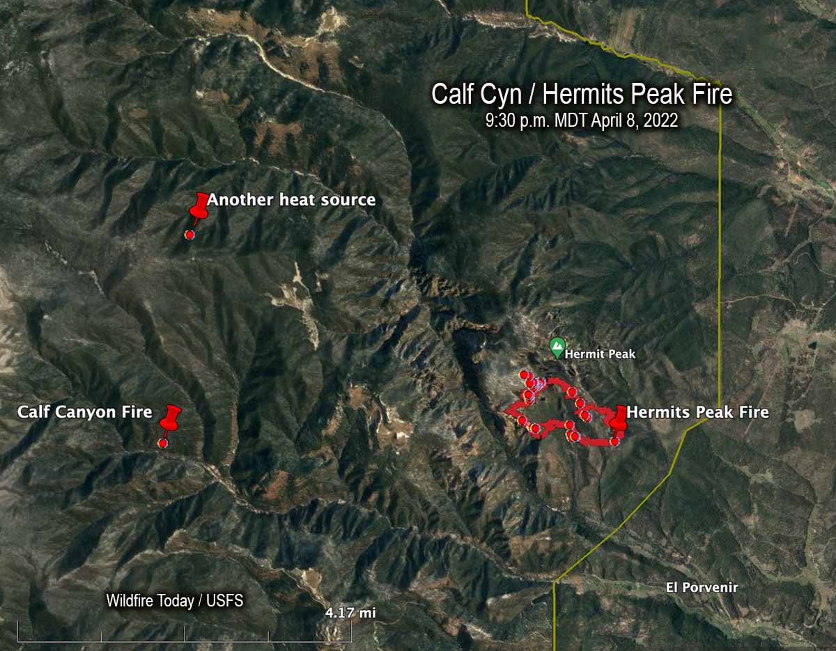
An April 8, 2022 map showing the Calf Canyon Fire before it grew large, another heat source nearby, and the Hermits Peak Fire.
The US Forest Service announced today that the Calf Canyon Fire northwest of Las Vegas, New Mexico was caused by piles that were still burning more than two months after they were ignited near the end of January, 2022. The heat remained after having been at times under snow when it was detected on April 9. The piles were comprised of vegetation and debris remaining after a fuel treatment project.
A statement released by the Santa Fe National Forest indicated that crews constructed a fireline around the 1.5-acre blaze on April 9 and “…continued to monitor the fire over the next couple of days to ensure there were no signs of heat or flames near the edge. Ten days later,” the statement continued, “on April 19 the Calf Canyon Fire reignited and escaped containment lines. A wind event on April 22 caused significant fire spread, and the Calf Canyon Fire merged with the Hermits Peak Fire, which was caused by an escaped prescribed burn.”
The term “reignited” is misleading. The burning piles were never completely put out. Wildfire Today found records showing that on April 8 fixed wing aircraft with thermal heat sensors began mapping the Hermits Peak Fire nearly every night the rest of the month. From imagery on April 8 at 9:30 p.m. MDT the Infrared Analyst noted two small heat sources both about 4 miles from the fire, one to the northwest and another almost due west which later became the Calf Canyon Fire. The heat to the northwest, 2.7 miles north of the Calf Canyon Fire, was not detected in subsequent mapping flights, indicating that it went out on its own or was successfully suppressed by firefighters.
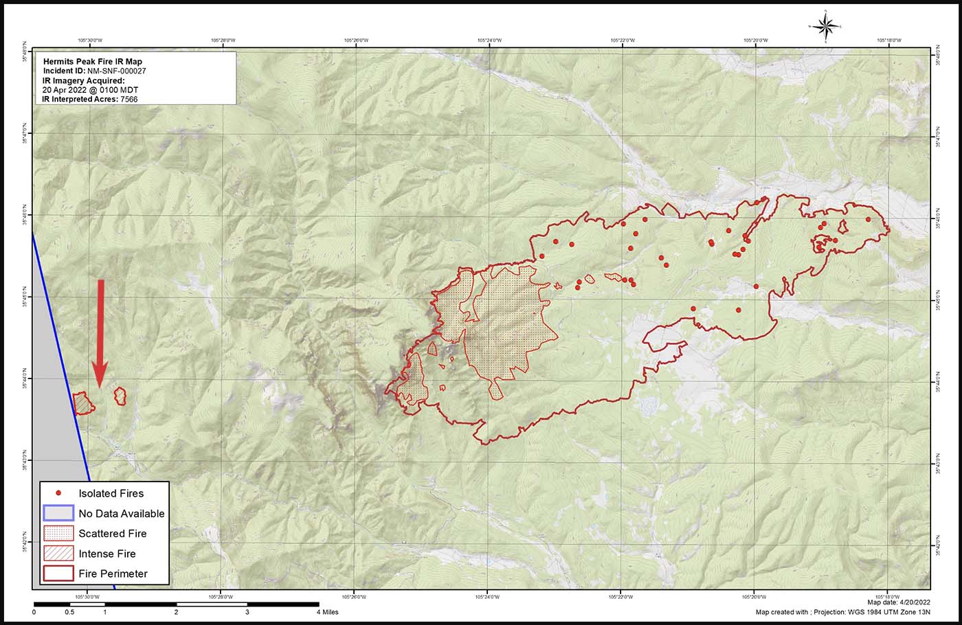
Map of the Calf Canyon and Hermits Peak Fires at 1 a.m. April 20, 2022 by the Incident Management Team. The red arrow, added by Wildfire Today, points to the Calf Canyon Fire which may have spotted, or there was an additional burn pile that spread.
Here are the results, related to what became the Calf Canyon Fire, of the Hermits Peak Fire aerial fire mapping from April 8 through April 21, 2022 (times are CDT):
8 @ 9:30 p.m.: heat noted at the pile burning site
9: (firefighters constructed line around a 1.5-acre fire spreading at the pile burning site)
10 @ 3 a.m.: heat noted
10 @ 10 p.m.: mapping mission unable to be filled (UTF)
11 @ 8:45: heat noted
13 @ 2 a.m.: not noted
13 @ 7:30 p.m.: not noted
14 @ 8:15 p.m.: not noted
15 @ 7:30 p.m.: not noted
16 @ 10 p.m.: UTF
18 @ 1:45 a.m.: not noted
18 @ 10 p.m.: UTF
20 @ 1 a.m.: intense heat noted at two locations at the pile burning site which were separately mapped by the Infrared Analyst. (See the map above. Either the fire spotted about 0.4 miles out ahead, or a second area in the pile burning project began spreading)
21 @ 1:30 a.m.: had grown to about 220 acres; was approximately half a mile wide and one mile long)
It is unknown if the mapping mission each night included the pile burning site four miles west of the Hermits Peak Fire, or if the Infrared Analyst was careful to examine the imagery for small detections of heat at the pile burning site.
After April 20 the Calf Canyon Fire was large and merged with the Hermits Peak Fire on the 22ndwhen both fires blew up. At that time the Hermits Peak fire was nearly contained and had been relatively quiet for several days, but pushed by very strong winds both fires ran 11 miles to the northwest in narrow parallel footprints until the wind speed decreased, allowing the flanks of both fires to spread laterally until they merged. The winds monitored at a weather station that day near Las Vegas, NM recorded sustained speeds of 40 to 50 mph with gusts up to 67 while the relative humidity dropped as low as 6 percent.
“We don’t have enough resources to do everything we want to do at one time so we have to prioritize the resources we have at the right location,” said Incident Commander Carl Schwope in a briefing on April 23.
The two merged fires, both the result of escaped prescribed fires and now called Calf Canyon / Hermits Peak Fire, are now 17 miles wide, 45 miles long, and have burned more than 312,000 acres, about 1/3 the size of Rhode Island. If you were driving from the south end of the fire at Las Vegas, NM on Highway 518 going north, it would take about an hour to reach the north edge of the fire near Angostura.
Map of the Calf Canyon / Hermits Peak Fire. The bright red dots represent heat detected by a satellite at 3:49 a.m. MDT May 20, 2022.
The four largest active wildfires in New Mexico all continued to grow Thursday and have burned a total of more than 476,000 acres. Red Flag Warnings are in effect Friday for winds gusting from 30 to 40 mph with single digit humidity.
The 303,701-acre Calf Canyon / Hermits Peak Fire northwest of Las Vegas was subject to single digit humidity and strong winds Thursday afternoon, 10 to 20 mph with 30 to 40 mph gusts out of the west. Since the east side is somewhat secure most of the additional spread was limited to the west side, which experienced in some areas fire behavior described as “extreme, crowning, group torching, and spotting.”
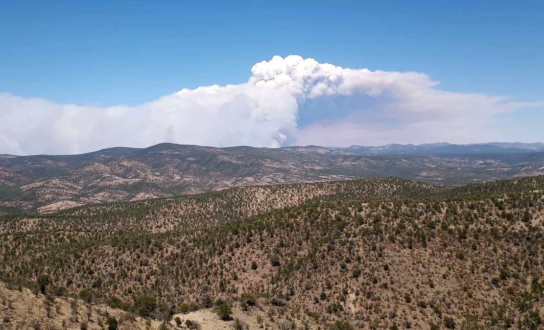
Smoke over the Calf Canyon – Hermits Peak Fire May 18, 2022 by pilot Travis Graham.
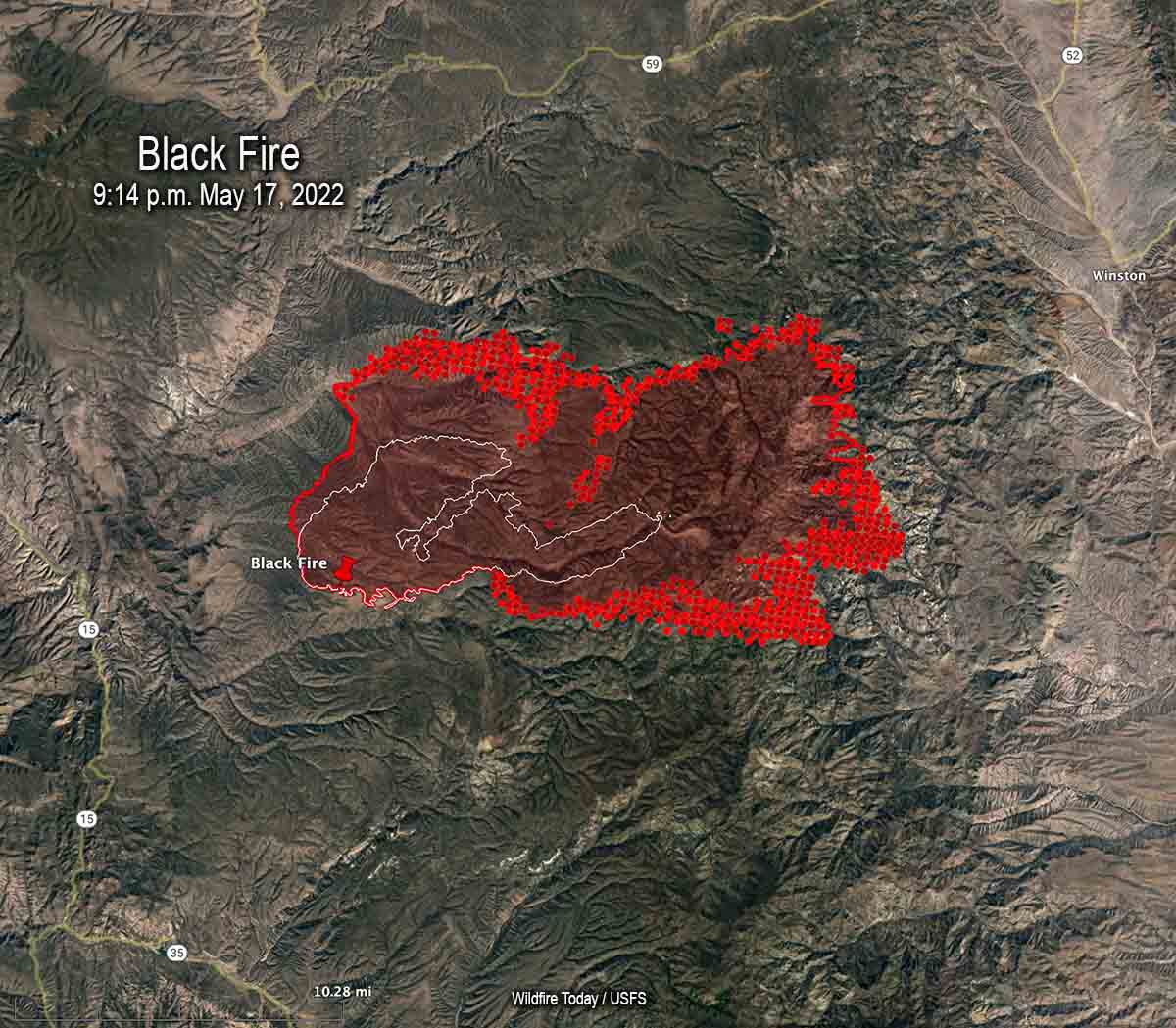
The Black Fire 28 miles west-northwest of Truth or Consequences consumed more vegetation on the northwest, northeast, east, and southeast sides. Fire officials said in some places it spread for three miles, growing on the southeast side to within one or two miles of Hermosa. It has burned 104,969 acres.
Map of the Black Fire. The bright red dots represent heat detected by a satellite at 3:49 a.m. MDT May 20, 2022.
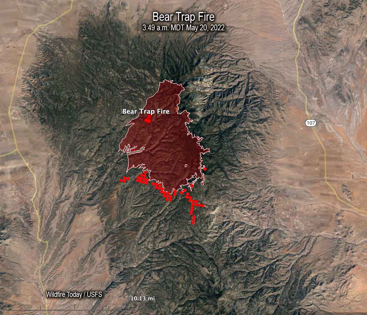
Most of the spread of the 21,687-acre Bear Trap Fire 34 miles southwest of Socorro was on the south side Thursday. Hand crews are prepping and conducting tactical burning operations, some of which may be conducted by aerial ignition. Limited movement to the east off the San Mateo crest is expected due to non-continuous fuels in several recent fire scars.
Map of the Bear Trap Fire. The bright red dots represent heat detected by a satellite at 3:49 a.m. MDT May 20, 2022.
The 45,605-acre Cerro Pelado Fire six miles southwest of Los Alamos has been relatively quiet for several days.
Red Flag Warning for the Calf Canyon / Hermits Peak Fire, May 19-20, 2022. NWS.
The National Weather Service has taken the unusual step of issuing a Red Flag Warning one and two days in advance for the Calf Canyon / Hermits Peak Fire 21 miles east of Santa Fe, New Mexico. The prediction is for winds gusting from the west and southwest at more than 30 mph with single digit relative humidity. Similar conditions will exist at least on Thursday for the area of the Black and Bear Trap Fires in southwest New Mexico.
Updated 12:10 p.m. MDT May 18, 2022
Map of the Black Fire. The bright red dots represent heat detected by a satellite at 2:48 a.m. May 18. The red line is the perimeter at 9:14 p.m. May 17. The white line is the perimeter about 48 hours before.
On Wednesday the northern half of New Mexico is under a Red Flag Warning. Isolated dry thunderstorms are predicted for portions of New Mexico, Texas, and Colorado.
Red Flag Warnings Wednesday.
Chance for isolated dry thunderstorms in portions of NM, CO, & TX.
From the NWS:
“Thunderstorms are expected across portions of the central Rockies this afternoon. Storms should be dry with the potential for new lightning induced fire starts.” pic.twitter.com/kT4KwlJC27
The Calf Canyon – Hermits Peak Fire 21 miles east of Santa Fe, NM was active on the west side Tuesday, but there was very little significant activity on the east side between Mora and Las Vegas.
The Cerro Pelado Fire 25 miles west of Santa Fe was relatively quiet Tuesday. There has been no major spread for several days and a satellite was only able to detect one large heat source early Wednesday morning.
Black Fire, May 16, 2022. IMT photo.
The Black Fire (see map above) 28 miles west-northwest of Truth or Consequences made another large run to the east Tuesday adding another 21,000 acres to bring the total up to 77,360. Fuel treatments and wildfires that have occurred over the last 20 years may slow any major spread to the north, west, and south, but the NIFC database shows no significant history of fire east of the incident.
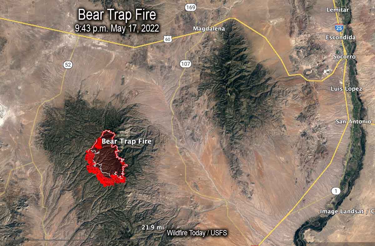
Map of the Bear Trap Fire. The bright red dots represent heat detected by a satellite at 2:48 a.m. May 18. The red line is the perimeter at 9:43 p.m. May 17. The white line is the perimeter about 24 hours before.
Another fire in southwest New Mexico, the Bear Trap Fire, is 34 miles southwest of Socorro. It spread southwest on Tuesday and was mapped Tuesday night at 15,215 acres. The fire is surrounded by fuel treatments and prescribed natural fires on all sides except for the southwest — which is where the most of the spread has occurred during the last couple of days.
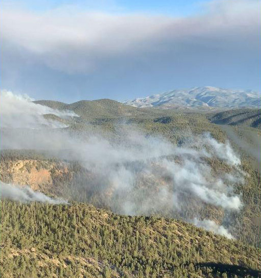
South side of the Bear Trap Fire, May 16. IMT photo.
5:10 p.m. MDT May 17, 2022
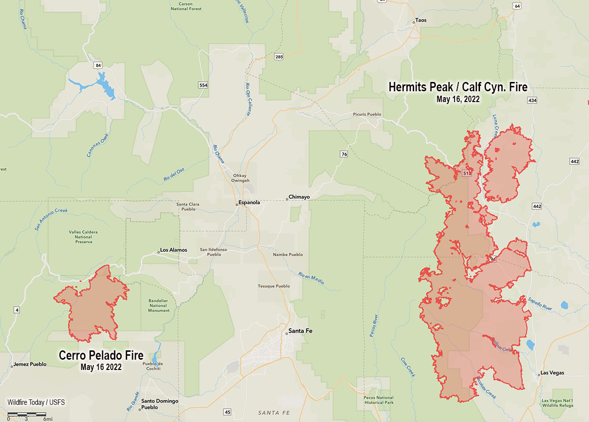
Map showing the location of the Cerro Pelado and Calf Canyon – Hermits Peak Fires, the evening of May 16, 2022.
High temperatures and very low humidity on Tuesday kept most of the large wildfires in New Mexico very active.
Calf Canyon – Hermits Peak Fire
The Calf Canyon – Hermits Peak Fire 21 miles east of Santa Fe has become the largest fire in the recorded history of New Mexico. At 299,565 acres it has eclipsed the previous record set by the 297,845-acre Whitewater and Baldy Fires when they burned together in May of 2012 in Southwest New Mexico. On Tuesday it was again putting up a large smoke column while a 5 to 20 mph wind gusted out of of the northwest, west, and southwest at 25 mph. The humidity dropped to 10 percent in the afternoon.
Cerro Pelado Fire
On Monday most of the fire activity on the 45,605-acre Cerro Pelado Fire was on the northwest and southeast sides. On Tuesday the fire 25 miles west of Santa Fe was putting up much less smoke than the Calf Canyon – Hermits Peak Fire, judging from the Satellite photo below taken at 3:56 p.m.