
Updated 2:02 p.m. CDT May 22, 2022
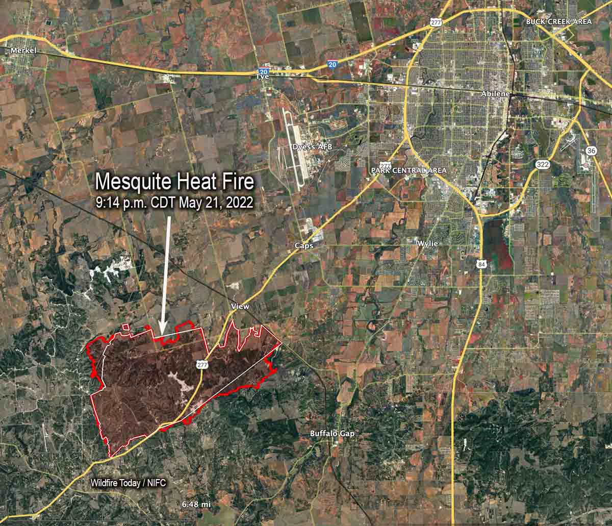
The Incident Management Team on the Mesquite Heat Fire 7 miles southwest of Abilene, Texas reports that it has burned 11,256 acres. The increase is due to more accurate mapping.
Active, open flame was reported Saturday morning on the eastern side of the fire although fire intensity was low. Minimal fire behavior is expected Sunday. However, fuels remain extremely dry and could support some moderate, low intensity growth.
Fire authorities have revised the number of homes destroyed from 27 to 20, with another 7 outbuildings destroyed.
Firefighters are focusing on the uncontained firelines along the north, west, and southern edges of the fire, assisted by heavy equipment.
Saturday at 8 a.m. the Southern Area Incident Management Gold Team assumed command led by Incident Commander Dave Martin and in unified command with the Taylor County Sheriff’s Office.
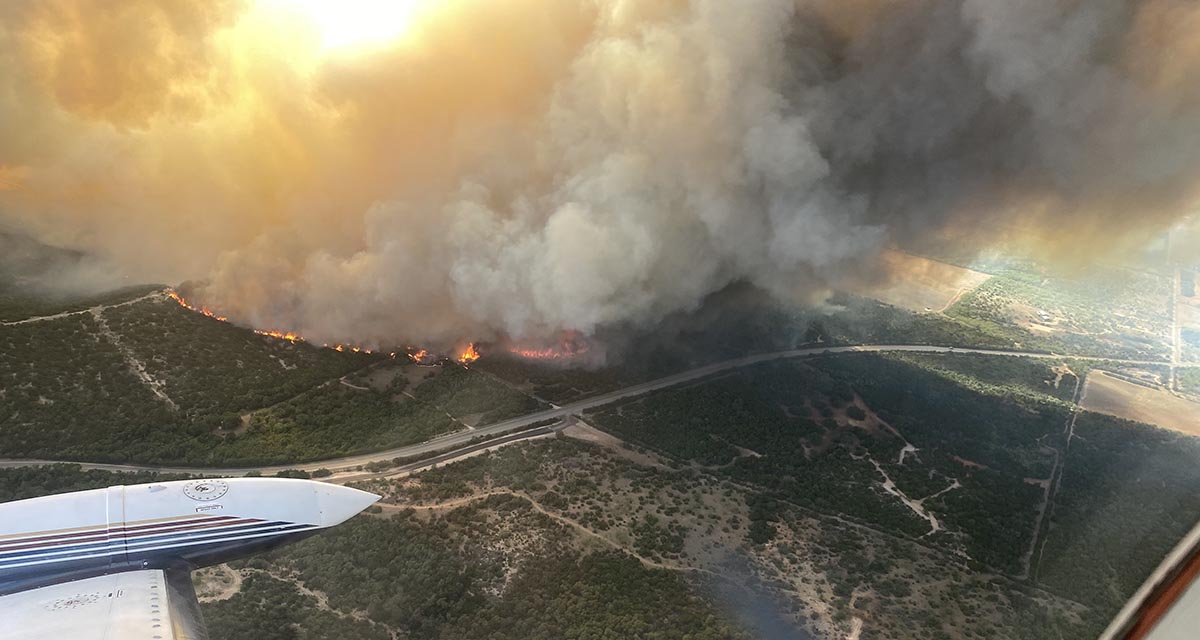
Here’s what driving down HWY277 looks like after the #MesquiteHeatFire passed through. Ash everywhere, some dead wildlife, crews working to restore power. @KTABTV @KRBCnews @bigcountryhome pic.twitter.com/a2fRkTuLSv
— Mercedez Hernandez (@SadieOnTV) May 21, 2022
10:35 a.m. CDT May 21, 2022
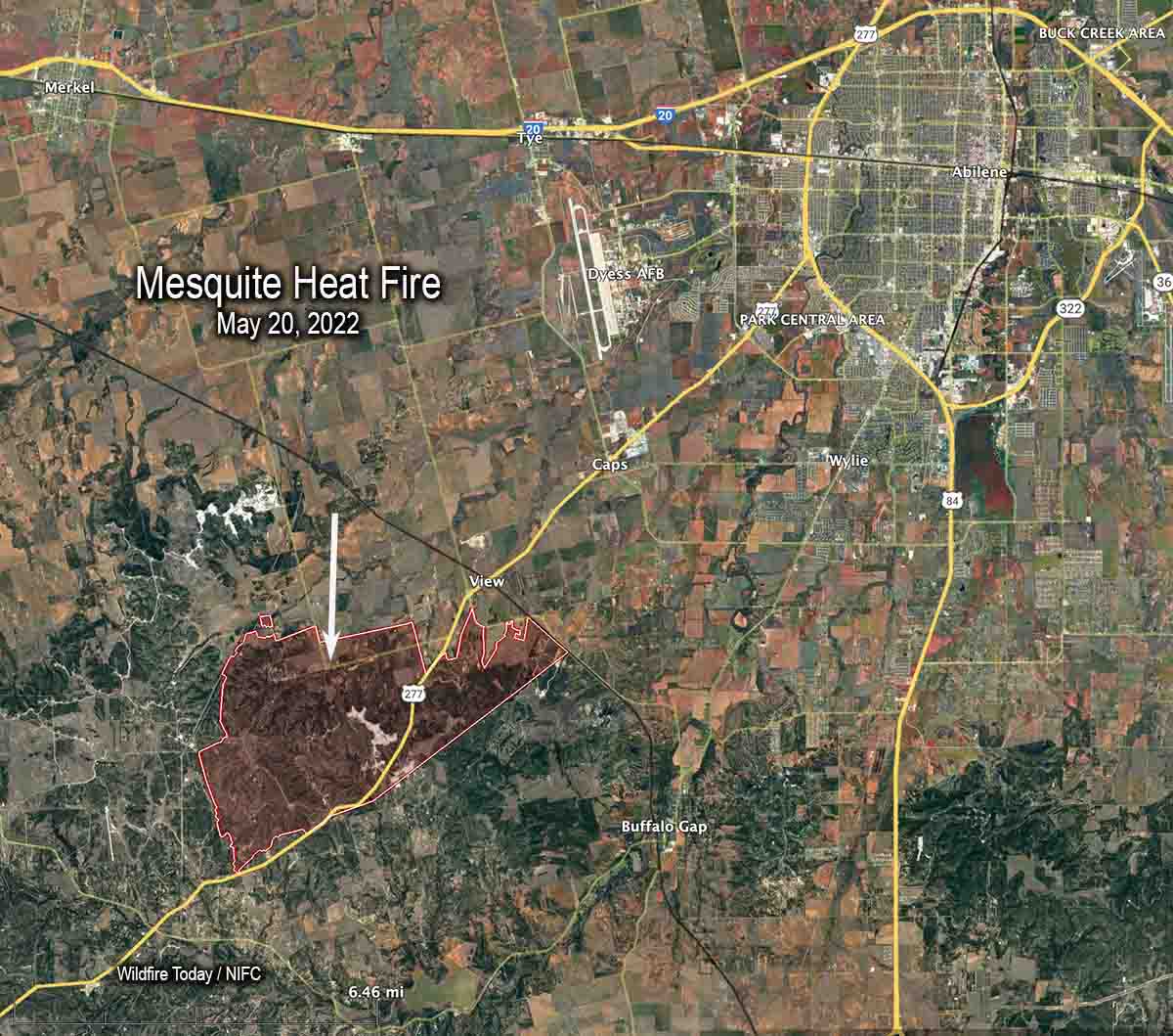
The Mesquite Heat Fire has destroyed approximately 27 homes 7 miles southwest of Abilene, Texas. Since it started May 17 alongside Highway 277 it has burned 7 miles to the northeast, consuming 9,613 acres during extreme weather conditions — temperature of 107 degrees, 10 percent relative humidity, and winds gusting to 30 mph.
Firefighters aided by aircraft kept it from spreading significantly Friday as unburned pockets of fuel flared up in the interior. Crews continued to construct containment line along the perimeter of the fire with a heavy focus on the southern flank in preparation for the predicted winds out of the north Saturday morning.
The Southern Geographic Area Incident Management Team #2 (Gold Team) is assigned. Resources on the fire Friday evening included 15 fire engines and 1 helicopter for a total of 59 personnel.
Friday evening evacuations were still in place with limited access for Country Place South to FM 89, South of FM 1235, Hillside Rd, Denton Valley Rd, Braune Rd and CR 297.
US Highway 277 reopened Friday night. The Taylor County Sheriff’s Office wrote on Facebook, “Several guardrails are only laying on the ground and reflective striping may not be visible or still present due to fire damage.”

You mean to tell me Texas hasn’t been keeping up on their raking??????
The most “fire resistant” property in my neighborhood has an owner who is an OBSESSIVE raker.
He completely clears the ground from pine needles, sticks, EVERYTHING, on about 15 acres of old growth forest.
So there is no fire danger on his property. There’s nothing to burn.
He gets upset because the local flying squirrels don’t nest on his property. That he is eliminating a primary source of food for the squirrels – the forest humus – does not compute in his head.
As far as the fire in Texas, where is it located relative to the fire near Abilene in March 2022 ?
The big fires in March were east of Abilene, this is S.W.
These people are doing everything in their power to save homes, lioves and anything else affected by this fire. I applaud their effort as they tirelessly fight this unpredictable blaze.
lives not lioves
My experience with Southern Geographic Area Incident Management Team #2 (Gold Team) last year on the Haypress Fire/River Complex was that they are not compotent. I hope the best for the Team, the crews assigned to the Incident, the communities they are working to save. Watch out for the Teams’ understanding of conditions, knowledge of locat resources at risk, and any firing operations they propose. Sorry to be negative, but I am still cleaning up and restoring the damage from their stint in northern CA last August-September….