7:16 a.m. PDT August 1, 2022

The Siskiyou County Sheriff’s Office announced early Monday morning that at about 10 a.m. Sunday two individuals were found deceased in a burned vehicle in the path of the McKinney Fire in Northern California. The vehicle was in a residential driveway along Doggett Creek Road off Highway 96 west of the community of Klamath River, California.
To see all articles on Wildfire Today about the McKinney Fire, including the most recent, click HERE.
Rain on the west side of the fire very early Sunday morning and a heavy smoke inversion helped limit growth Sunday, but also kept aircraft mostly grounded. The weather station on Mt. Baldy on the western edge of the fire received just over half an inch, Scott Barr three miles west of the fire got 0.19″, and Oak Knoll off Highway 96 received 0.01″. Several locations near Yreka recorded no precipitation.

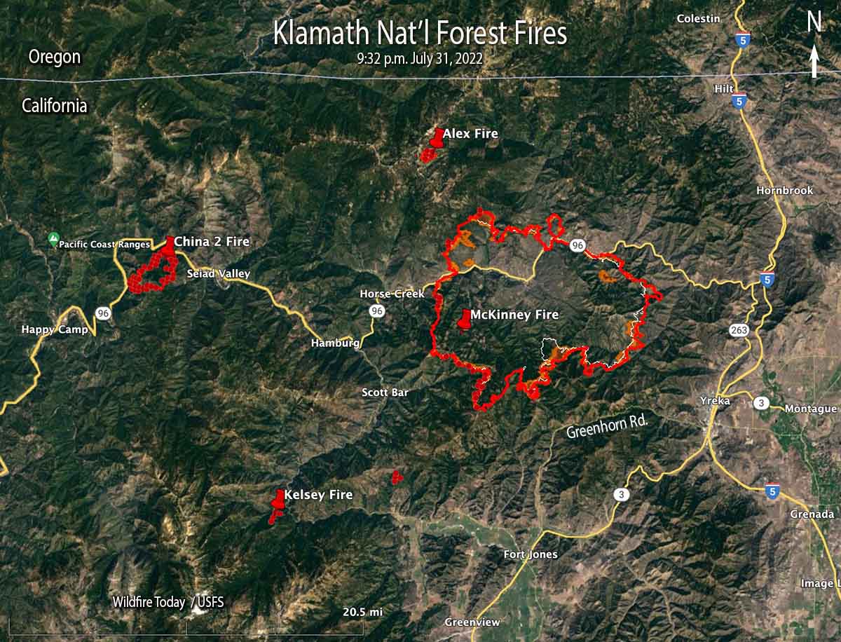
The fire was mapped Sunday night at approximately 55,493 acres. It is being managed under Unified Command with the US Forest Service and the CAL FIRE.
Saturday night the McKinney Fire was:
- 5 miles from Yreka
- 6 miles from Interstate 5
- 9 miles from Fort Jones
- 4 miles from Scott Bar
- 2 miles from Horse Creek
The Siskiyou County Sheriff’s Office ordered evacuations of more than 2,000 people near Yreka. Details can be found on their Facebook page. A Zonehaven Aware map is also available.
The Siskiyou County Sheriff’s Office has confirmed that several structures have been destroyed. Sheriff’s office Spokeswoman Courtney Kreider said residences along Highway 96 in the Klamath River drainage burned. She did not have a specific number. An online video shows that the Community Hall in Klamath River burned.
At least 10 fires, including the McKinney Fire, were burning in Siskiyou County as of late Sunday night, according to the Siskiyou County Office of Emergency Services.
Fire officials said the spread of the Alex Fire near Condrey Mountain four miles north of the McKinney Fire has been stopped. It was mapped at about 140 acres.
The China Fire west of Seiad has burned 1,989 acres south of Highway 96.
The Kelsey Fire was 10-15 acres Sunday afternoon and has evacuation orders in place. Numerous resources are on scene and more continue to arrive. It is west of Scott River Road nine air miles southwest of Scott Bar.
Highway 96 is closed and Interstate 5, which is six miles east of the fire, remains open.
Monday’s weather forecast calls for a 25 percent chance of showers and isolated thunderstorms with a high of 80 to 93 degrees with the humidity dropping into the 20s in the lower elevations. The wind will be out of the west at 4 to 7 mph with gusts to 14 mph.
