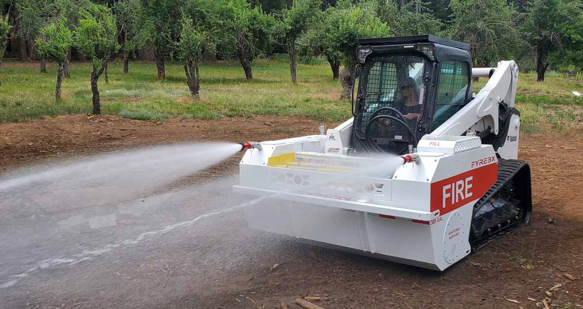
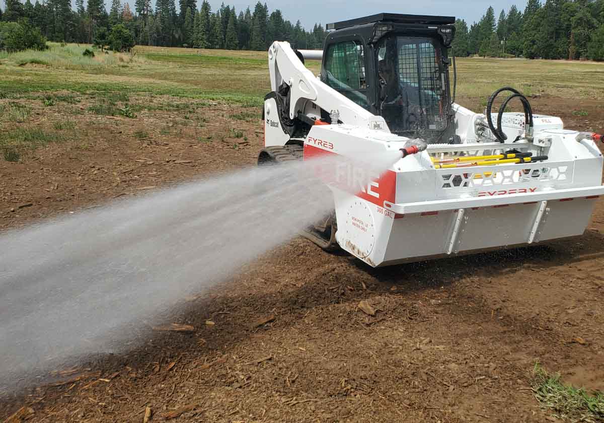
A company in Redding, California has developed an attachment for a skid steer loader, such as a Bobcat, that enables them to be converted to a firefighting apparatus.
The FYREBX has a 300-gallon water tank with a pump powered by the skid steer’s hydraulic system. It can flow water at 5 gallons per minute up to 250 gallons per minute. One person can apply water from the cab using the two nozzles on the device, or a hose can be connected operated by a firefighter on the ground.
The operator inside the cab can turn the hydraulic power to the pump on or off, but the controls for varying the pressure and volume of water are on the outside of the FYREBX.
FYREBX photo
There are various ways the tank can be refilled, including driving the skid steer into a body of water and lowering the unit so that the submersible pump can fill the tank.
Matthew Wilson, the company’s Vice President for Sales and Service, told Wildfire Today that they have sold units to forestry companies and are in talks with the US Air Force about a sale of multiple units to be used at Air Force bases on the West Coast. He said the California Department of Forestry and Fire Protection is also evaluating the FYREBX.
For the purchase price of $18,950, it comes with the equipment the US Forest Service requires for timber companies in a “fire box”, 3 shovels, 2 axes, 1 pulaski, mcleods, 1 fire extinguisher, 100 ft of 1.5″ wildland hose, and 200 feet of 3/4″ wildland hose, said Sean Henry, President of the company. An optional accessory is a compressed air foam system.
The AlertWildfire camera in Northern California on Herd Peak recorded the effect of what is likely outflow winds from a thunderstorm affecting smoke from the McKenney Fire. At the time on Sunday afternoon July 31, 2022 it had burned about 52,000 acres northwest of Yreka. It appears that the fire is spreading across the ground, but most likely it is just smoke.
To see all articles on Wildfire Today about the McKinney Fire, including the most recent, click HERE.
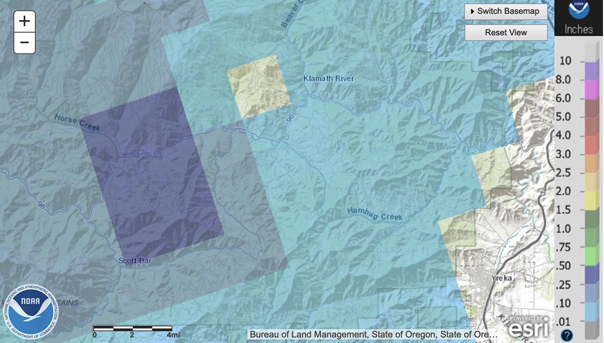
Rain on the fire
It was very spotty, but some locations on the McKinney Fire received rain Saturday night between 10 p.m. and 3 a.m. Sunday morning. The weather station on Mt. Baldy on the western edge of the fire received just over half an inch, Scott Barr three miles west of the fire got 0.19″, and Oak Knoll off Highway 96 received 0.01″. Several locations near Yreka recorded no precipitation.
There are very few weather stations in or near the fire area, but the National Weather Service produced the map below with estimated precipitation amounts based on radar observations.
Radar observed precip, for the 24-hour period ending at 5 a.m. PDT July 31, 2022. NWS.
The west side of the fire received the most precipitation, according to the radar, with much less on the east side. The radar data is just an estimate, but it appears possible that a good sized portion of the west side received at least a wetting rain, with much of that side experiencing between 0.10 and 0.50″. If this is the case, the east side should see more fire growth for at least the next day or so than on the west side.
Fire activity
The rain combined with an inversion Saturday evening to slow the fire, but activity increased in some locations around midnight. Crews were actively engaged in structure protection in the Klamath River area. Little progression was observed on the southeast side closest to Yreka.
The McKinney Fire was mapped Sunday afternoon at 52,499 acres. The China 2 Fire 15 miles west of the McKinney Fire has burned 1,652 acres on the south side of Highway 96.
Sunday
Priorities for Sunday are to continue structure preparation and protection in the Highway 96 corridor, and around the communities of Fort Jones and Yreka.
Homes destroyed
The Siskiyou County Sheriff’s Office has confirmed that several structures have been destroyed. Sheriff’s office Spokeswoman Courtney Kreider said residences along Highway 96 in the Klamath River drainage burned. She did not have a specific number.
Updated at 5:36 a.m. PDT July 31, 2022
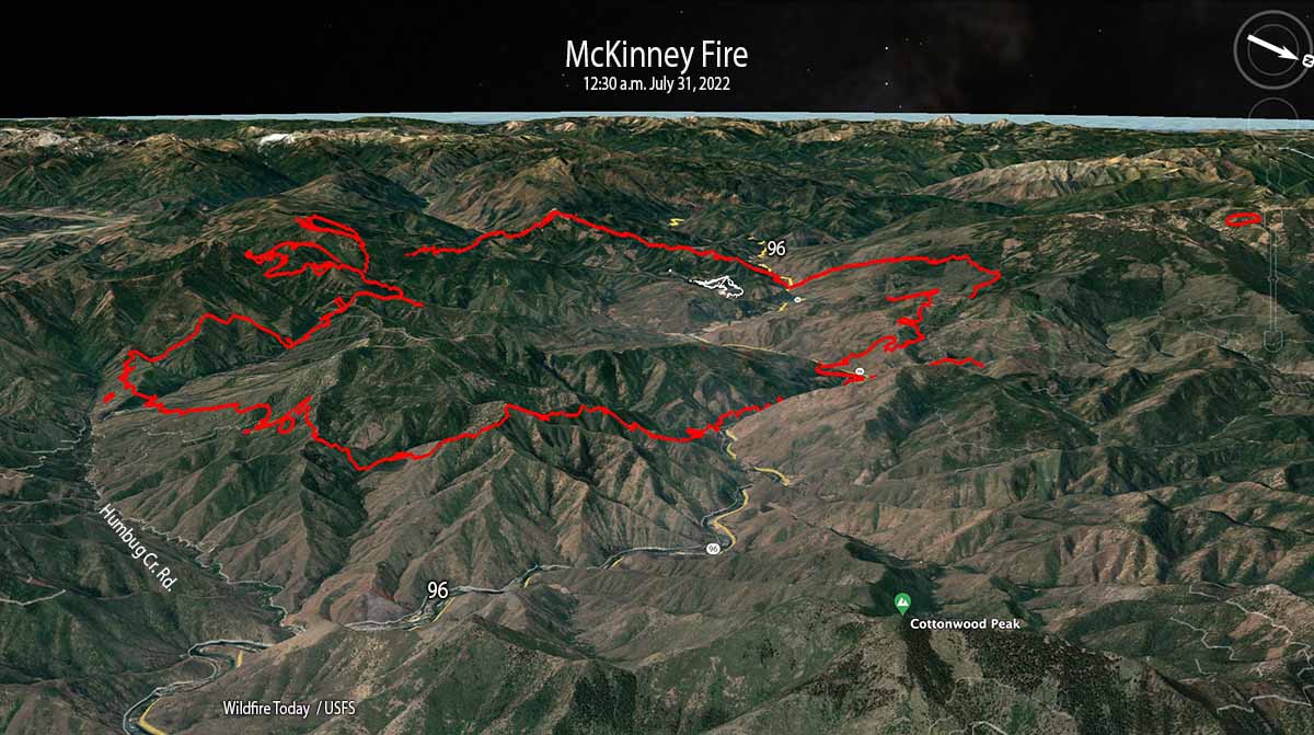
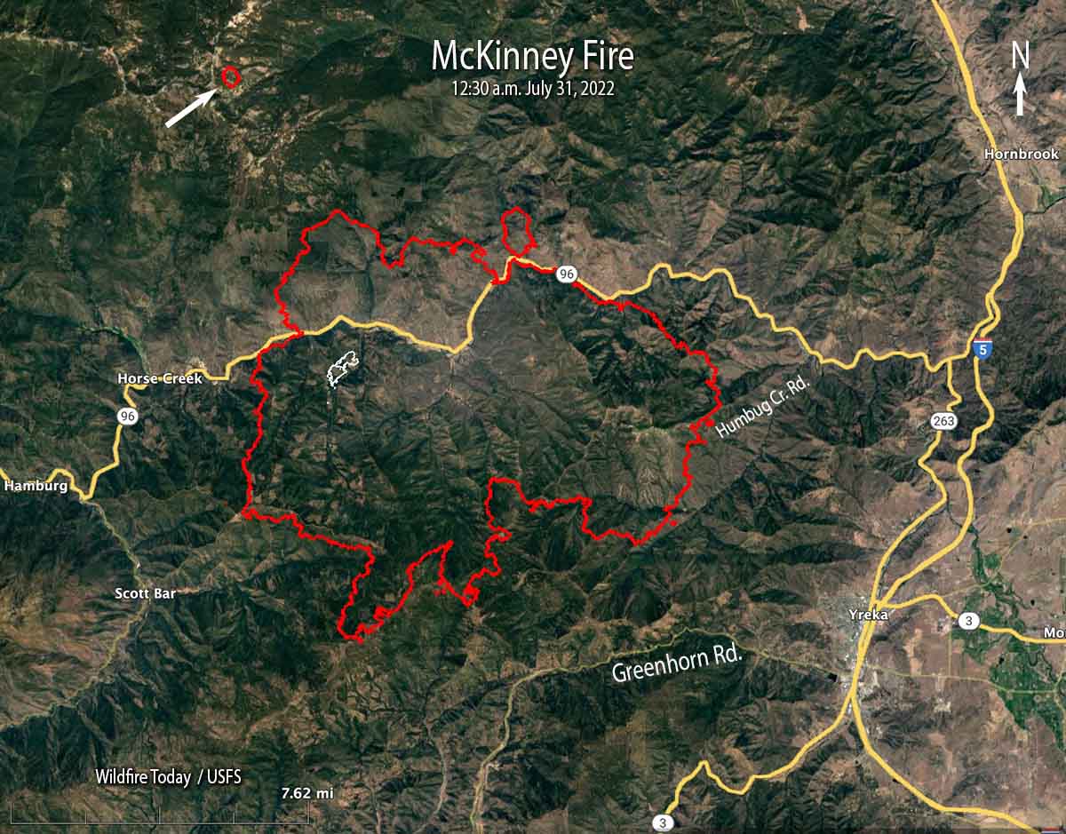
McKinney Fire 3-D map, looking west-southwest at 12:30 a.m. PDT July 31, 2022. The white lines were the perimeter at 5:19 p.m. on July 29.
The McKinney Fire in Northern California eight miles south of the Oregon state line was very active throughout the night. When it was mapped by an aircraft at 12:30 a.m. Sunday it had grown to 51,468 acres. During a satellite overflight at 3:38 a.m. about 90 percent of the heat detected was on the east and southeast sides.
This was the only complete mapping of the fire since noon on Saturday due to thunderstorms and lightning in the area which restricted flights of air tankers and helicopters.
McKinney Fire map at 12:30 a.m. PDT July 31, 2022. The white line was the perimeter at 5:19 p.m. on July 29.
At 12:30 a.m. Sunday it was 5 miles northwest of Yreka, 2 miles north of Greenhorn Road, 5 miles west of Highway 263, 4 miles east of Scott Bar, and 2 miles east of Horse Creek.
The mapping flight found a 75-acre fire burning four miles northwest of the McKinney Fire east of Condrey Mountain. It is unknown at this point if it a new fire or a spot from the McKinney.
Another fire 15 miles west of the McKinney Fire, the China 2 Fire, has burned approximately 1,000 acres south of Highway 96 in the Seiad Valley area.
Weather
Isolated and scattered thunderstorms with little or no rain are predicted for the area on Sunday with gusty outflow winds of 40-50 mph and cloud to ground lightning. Pyrocumulus could regenerate with potential for rapid fire growth and spread. There is a 5 percent chance of wetting rain. The relative humidity will be 15 to 25 percent.
Updated 6:41 p.m. PDT July 30, 2022
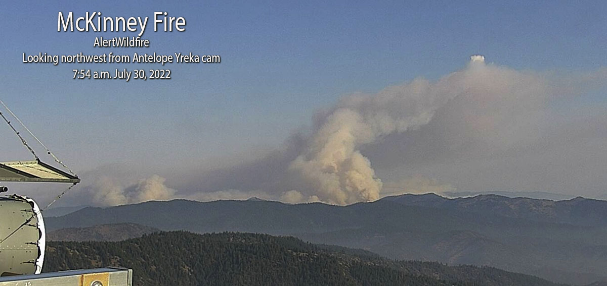
Saturday afternoon the area around the McKenny Fire northwest of Yreka, California was covered by cumulonimbus clouds, thunderstorms with lightning. This made it very difficult for air tankers, helicopters, or mapping aircraft to work over the blaze. Even the AlertWildfire cameras on mountain peaks late in the afternoon could see nothing but smoke. But satellite imagery peeking through breaks in the clouds detected intense heat from the fires.
The video below shows lightning and heat detected by a satellite during a 2-hour period ending at 6:21 p.m. PDT July 30 in Northern California and southwest Oregon. The red areas represent heat from the fires. The white line is the Oregon/California border. The white flashes are lightning.
Evacuations are in effect over a large area, ordered by the Siskiyou County Sheriff. Details can be found on their Facebook page. A Zonehaven Aware map is also available.
At 3 p.m. Saturday the US Forest Service estimated the fire had burned 30,000 to 40,000 acres.
Updated 1:20 p.m. PDT July 30, 2022
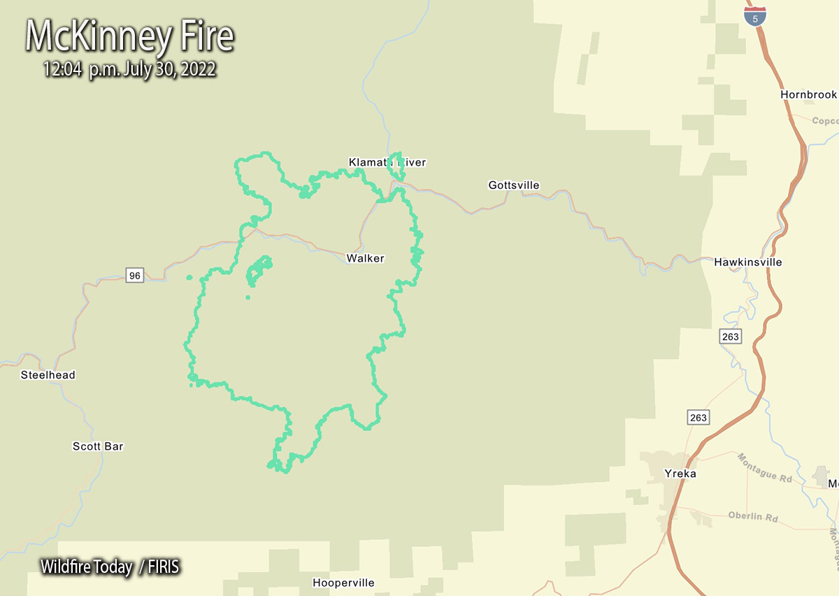
McKinney Fire map, 12:04 p.m July 30, 2022
The FIRIS aircraft mapped the McKinney Fire at an astounding 29,493 acres just after noon today. That explosive growth is less than 24 hours after it was reported at 2:15 p.m. Friday. (See map above)
This current map shows us that at 12:04 p.m. Saturday it was 9 miles west-northwest of Yreka, 3 miles northwest of Scott Bar, and 3 miles west of Gottsville.
During its first 22 hours it spread north 4 miles, east 5 miles, south 6 miles, and west about 2 miles.
9:48 a.m. PDT July 30, 2022
The McKinney Fire northwest of Yreka, California grew rapidly after it was reported Friday afternoon south of Highway 96 in the Klamath National Forest. Since then it has spread north across the highway and also to the south. At about 5 a.m. Saturday the Siskiyou County Sheriff said it was approximately four miles from Scott Bar after having been very active all night.
At about 8:45 a.m. on Saturday the Klamath National Forest estimated it had burned approximately 18,000 acres. The most recent perimeter map available is from Friday at 5:19 p.m., when it was only 65 acres. This current estimate from the Forest Service indicates it is 277 times larger. Additional perimeter mapping data was most likely prevented by lightning and thunderstorms in the area.
The fire was 14 miles northwest of Yreka when first reported, but grew closer overnight.
Evacuations are in effect over a large area, ordered by the Siskiyou County Sheriff. Details can be found on their Facebook page. A Zonehaven Aware map is also available.
Larger plumes send more smoke higher into the atmosphere where it can spread farther
Pyrocumulonimbus cloud over the Bootleg Fire in Oregon, July 14, 2021. InciWeb.
By Paul Gabrielsen Science writer, University of Utah
In recent years, the plumes of smoke crawling upward from Western wildfires have trended taller, with more smoke and aerosols lofted up where they can spread farther and impact air quality over a wider area. The likely cause is climate change, with decreased precipitation and increased aridity in the Western U.S. that intensifies wildfire activity.
“Should these trends persist into the future,” says Kai Wilmot, a postdoctoral researcher in the Department of Atmospheric Sciences at the University of Utah, “it would suggest that enhanced Western U.S. wildfire activity will likely correspond to increasingly frequent degradation of air quality at local to continental scales.”
The study is published in Scientific Reports and supported by the iNterdisciplinary EXchange for Utah Science, or NEXUS, at the University of Utah.
Smoke height
To assess trends in smoke plume height, Wilmot and University of Utah colleagues Derek Mallia, Gannet Haller and John Lin modeled plume activity for around 4.6 million smoke plumes within the Western U.S. and Canada between 2003 and 2020. Dividing the plume data according to EPA ecoregions (areas where ecosystems are similar, like the Great Basin, Colorado Plateau, and Wasatch and Uinta Mountains in Utah) the researchers looked for trends in the maximum smoke plume height measured during August and September in each region in each year.
In the Sierra Nevada ecoregion of California, the team found that the maximum plume height increased, on average, by 750 ft (230 m) per year. In four regions, maximum plume heights increased by an average of 320 ft (100 m) per year.
Why? Wilmot says that plume heights are a complex interaction between atmospheric conditions, fire size and the heat released by the fire.
“Given climate-driven trends towards increasing atmospheric aridity, declining snowpack, hotter temperatures, etc., we’re seeing larger and more intense wildfires throughout the Western U.S.,” he says. “And so this is giving us larger burn areas and more intense fires.”
The researchers also employed a smoke plume simulation model to estimate the mass of the plumes and approximate the trends in the amount of aerosols being thrown into the atmosphere by wildfires . . . which are also increasing.
The smoke simulation model also estimated the occurrence of pyrocumulonimbus clouds—a phenomenon where smoke plumes start creating thunderstorms and their own weather systems. Between 2017 and 2020, six ecoregions experienced their first known pyrocumulonimbus clouds and the trend suggests increasingly frequent pyrocumulonimbus activity on the Colorado Plateau.
Taller plumes send more smoke up into higher elevations where it can spread farther, says John Lin, professor of atmospheric sciences.
“When smoke is lofted to higher altitudes, it has the potential to be transported over longer distances, degrading air quality over a wider region,” he says. “So wildfire smoke can go from a more localized issue to a regional to even continental problem.”
Are the trends accelerating?
Some of the most extreme fire seasons have occurred in recent years. So does that mean that the pace of the worsening fire trend is accelerating? It’s too early to tell, Wilmot says. Additional years of data will be needed to tell if something significant has changed.
“Many of the most extreme data points fall within the years 2017 -2020, with some of the 2020 values absolutely towering over the rest of the time series,” he says. “Further, given what we know of the 2021 fire season, it appears likely that analysis of 2021 data would further support this finding.”
In Utah’s Wasatch and Uinta Mountains ecoregion, trends of plume height and aerosol amounts are rising but the trends are not as strong as those in Colorado or California. Smoke from neighboring states, however, often spills into Utah’s mountain basins.
“In terms of the plume trends themselves, it does not appear that Utah is the epicenter of this issue,” Wilmot says. “However, given our position as generally downwind of California, trends in plume top heights and wildfire emissions in California suggest a growing risk to Utah air quality as a result of wildfire activity in the West.”
Wilmot says that while there are some things that people can do to help the situation, like preventing human-caused wildfires, climate change is a much bigger and stronger force driving the trends of less precipitation, higher aridity and riper fire conditions across the West.
“The reality is that some of these [climate change] impacts are already baked in, even if we cut emissions right now,” Wilmot adds. “It seems like largely we’re along for the ride at the moment.”
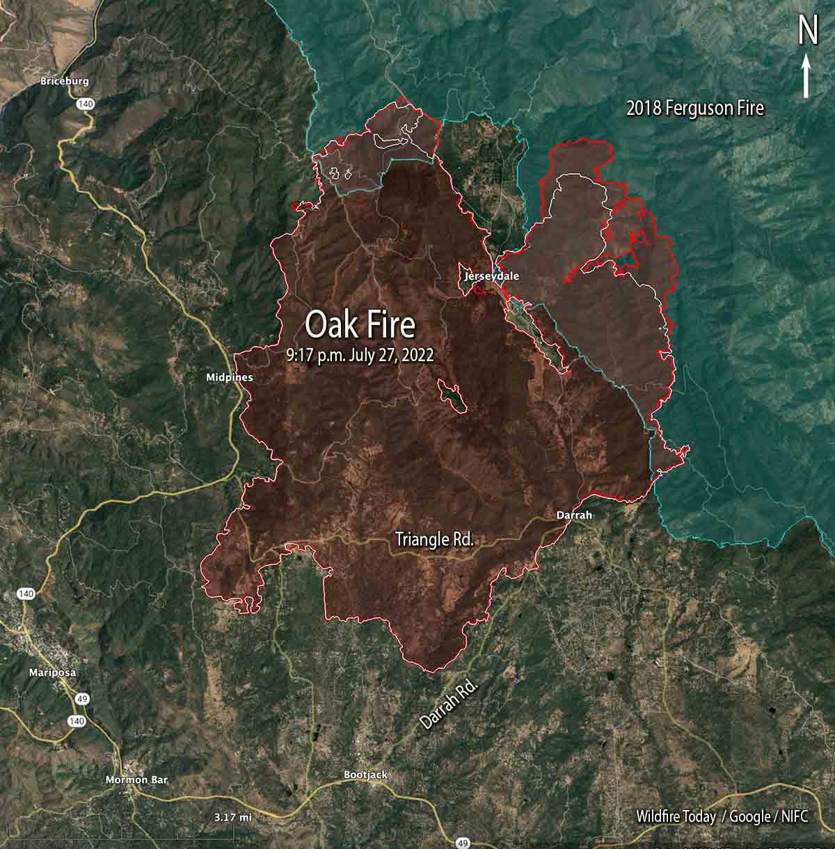
Oak Fire map. The red line was the perimeter at 9:17 p.m. July 27, 2022. The white line was the perimeter about 48 hours before.
Most of the perimeter of the Oak Fire northeast of Mariposa, California was quiet on Wednesday, with the exception of the north and northeast sides where it has continued to spread. Firefighters have constructed firelines in those areas, some of them indirect, and are making progress. It has moved one to two miles into the footprint of the 2018 Ferguson Fire.
To see all articles on Wildfire Today about the Oak Fire, including the most recent, click HERE.
The fire was mapped Wednesday night at 19,169 acres.
The video below was shot by the FIRIS aircraft looking south at the northeast side of the fire at 9:20 p.m. July 27. White indicates heat.
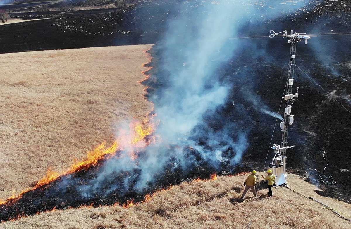
Argonne scientists monitor a controlled burn on the Konza prairie in Kansas using the Sage monitoring system. (Image by Rajesh Sankaran/Argonne National Laboratory.)
Scientists recently deployed a complex array of sensors during a prescribed fire at the Konza tallgrass prairie in Kansas to collect a vast trove of data. It was immediately processed at the site using advanced computing technologies provided by a new platform called Sage.
Sage offers a one-of-a-kind combination that involves multiple types of sensors with computing “at the edge”, as well as embedded machine learning algorithms that enable scientists to process the enormous amounts of data generated in the field without having to transfer it all back to the laboratory. Computing “at the edge” means that data is processed where it is collected, in the field, while machine learning algorithms are computer programs that train themselves how to recognize patterns.
Sage is funded by the National Science Foundation and developed by the Northwestern-Argonne Institute for Science and Engineering (NAISE), a partnership between Northwestern University and the U.S. Department of Energy’s Argonne National Laboratory.
Equipment used to monitor a controlled burn on the Konza prairie in Kansas using the Sage monitoring system. (Image by Rajesh Sankaran/Argonne National Laboratory.)
The advanced cyberinfrastructure deployed in Sage, which allows for on-the-spot detection, monitoring, and analysis of the burned area, could offer scientists and natural resources officials the ability to get ahead of forest fires with quickly analyzed, multi-instrumented data.
“When it comes to forest fires, time is absolutely of the essence,” said Argonne computational scientist and NAISE Fellow Rajesh (Raj) Sankaran. “Often, there’s no time to move data from the field — where high-speed connectivity might be an issue — to the lab. With Sage, we’re getting the pertinent information we need when we need it.”
The prescribed fire in the Konza prairie gave the researchers a large collection of data — almost 60 DVDs worth — full of information about the progression of smoke and fire. This data can be used to educate a machine learning algorithm that can make further determinations of the behavior of other fires in real time.
After the success of the Sage network in Kansas, future plans exist for the network to be deployed in California, Colorado, Illinois, and Texas as part of a network led by the National Ecological Observatory Network (NEON). Eventually, researchers hope to establish a continent-spanning network of smart sensors that could employ Sage technology.
“NEON is developing a mobile deployment platform that can complement land-based and aquatic sites all over the country,” Sankaran said. “Sage can play a supportive role in many different environments throughout the United States.”
The House of Representatives narrowly passed the legislation Friday. Now it goes to the Senate.
12:46 EDT, July 27, 2022
Rep. Joe Neguse interviewed on CNN July 27, 2022 about the Wildfire Response and Drought Resiliency Act.
In this video from CNN, Brianna Keilar interviews Colorado Rep. Joe Neguse about the Wildfire Response and Drought Resiliency Act, H.R. 5118, which would benefit wildland firefighters. It boosts their pay and benefits, helps the Forest Service fill gaps in fire management staff, and promotes bigger forest management projects to reduce hazardous fuels.
The bill is a conglomeration of half a dozen pieces of legislation, including the Tim Hart Wildland Firefighter Pay Parity Act (H.R. 5631), all rolled into one. It would require that the minimum basic pay for any Federal wildland firefighter position be no less than the pay for a GS-6 Step 3, which is $42,946 a year ($21.29 an hour). It would also stipulate that the salary be adjusted annually by not less than the change in the Consumer Price Index.