County Sheriff says 991 structures destroyed in Marshall Fire southeast of Boulder, Colorado

Updated 8:12 p.m. MST Jan. 1, 2022

County authorities have have released a preliminary list of the addresses of structures that were destroyed or damaged in the Marshall Fire southeast of Boulder, Colorado. They described it as partial and incomplete at 2 p.m. January 1, 2022.

From the Denver Gazette, Saturday evening:

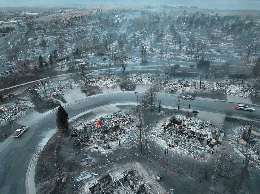
Three people are missing and feared dead in the wake of the Marshall fire, the Boulder County sheriff said Saturday [afternoon], and nearly 1,000 structures have been destroyed, making the blaze by far the most destructive in Colorado history.

Two of the three missing persons are in Superior, and the third is in the Marshall area, Sheriff Joe Pelle said. He said the search is likely a recovery one, meaning authorities are looking for remains. The missing people’s homes have been destroyed, he said, and cadaver dogs will be brought in Sunday. The debris and snow have “hampered substantially” efforts to search for the missing.

To see all articles on Wildfire Today about the Marshall Fire, including the most recent, click here: https://wildfiretoday.com/tag/marshall-fire/

Thanks and a tip of the hat go out to Minnie and Pat.


6:12 p.m. MST Jan. 1, 2022

Map, Marshall Fire, Dec. 31, 2021 Colorado
Map, Marshall Fire, Dec. 31, 2021.

Unlike most states, in Colorado county sheriffs have statutory responsibility to coordinate wildland fire response within their county. Boulder County, the location of the Marshall Fire, has five year-round employees with fire responsibilities. They also hire seasonal firefighters during the traditional wildland fire season.

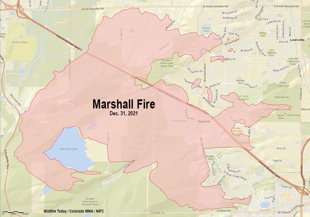
Saturday afternoon Boulder County Sheriff Joe Pelle released damage assessment numbers for the 6,000-acre Marshall Fire southeast of Boulder.

Total numbers are 991 structures destroyed and 127 damaged.

Louisville:
Destroyed – 553
Damaged – 45

Superior:
Destroyed – 332
Damaged – 60

Unincorporated Boulder County:
Destroyed: 106
Damaged: 22

The Sheriff did not specify how many of the structures were homes. Therefore, the numbers could include backyard sheds and other small uninhabited buildings.

What caused the Marshall fire?

Boulder County has clarified information that was previously released about the cause of the fire. In a press conference Friday morning, Sheriff Pelle told reporters that someone told fire authorities that there was a downed power line near where the fire started. But origin and cause investigators had not examined the scene, he said, and the specific cause had not been officially confirmed.

Saturday afternoon the Boulder Office of Emergency Management released a statement:

As of last night, no downed power lines had been located in the area [of the origin]. There were some downed telecommunication lines, but these are not likely to have started the blaze. The sheriff did confirm that one search warrant has been obtained, but he declined to release any additional information about the location or reason for the warrant.

Photos show devastation after the 6,000-acre Marshall Fire in Colorado

The surviving homes in subdivisions that were destroyed had a common feature

Marshall Fire, Louisville, Colorado, by WxChasing/Brandon Clement
Marshall Fire, Louisville, Colorado. Photo by WxChasing/Brandon Clement, Dec. 31, 2021.

Early Friday morning, about 20 hours after the Marshall Fire ignited, a drone operated by Twitter user WxChasing/Brandon Clement flew over subdivisions that were devastated by the December 30 fire. It found block after block of ash piles, some still smoldering. In many scenes there was scarcely a structure still standing. (Scroll down to see the video.)

To see all articles on Wildfire Today about the Marshall Fire, including the most recent, click here: https://wildfiretoday.com/tag/marshall-fire/

All of the reasons why some houses did not burn even though dozens around them were consumed could not be determined from the video, but there was one common feature — the survivors were more distant from the neighboring homes. Many houses in the subdivisions were only 10 to 20 feet apart based on archived imagery in Google Earth.

The fire was driven by very strong winds gusting at 60 to 100 mph, extremely dry conditions after months of drought, and relative humidity in the mid-20s. These are the very worst fire conditions. The weather paired with the nearly back to back structures led to the fire spreading through a continuous human-made fuel bed. When one house burned the convective and radiant heat easily ignited its neighbor, which ignited its neighbor, etc.

The fire in the vegetation and structures lofted burning materials far downwind, creating distant spot fires in the home ignition zone on bone dry lawns, mulch beds around ornamental plants, and on structures. It is unknown at this point how many had been designed and built to be fire resistant, such as the characteristics of the roof, vents, siding, doors, windows, foundation, fences, eaves, and decks. A FEMA publication (13 MB) has excellent detailed recommendations. Headwaters Economics found that the cost of building a fire-resistant home is about the same as a standard home. Local building codes could regulate these features. But if the lot size is so small that residences are only 10 to 20 feet apart, if one becomes fully involved, the neighbors also burn, especially during windy conditions.

So far we have listed some factors that affect the vulnerably of structures during a wildland-urban interface fire: home spacing and lot size, the envelope of the structure itself, fire codes, and the home ignition zone. Others are:

  • Evacuation capability and planning;
  • Safety zones where residents can shelter in place;
  • Road and driveway width, wide enough for large fire trucks;
  • Turnarounds at the end of roads;
  • Signage, and;
  • Emergency water supply.

The video below of the Marshall Fire devastation was shot by WxChasing/Brandon Clement at first light on December 31, 2021, the day after the fire started. Not long after, snow began falling. The National Weather Service in nearby Boulder recorded an accumulation of eight inches.