The Spruce Creek Fire took off on May 14 and is burning on the San Juan National Forest northeast of Dolores, Colorado. The fire’s inside a network of FS roads within an established RxFire burn unit. Two hotshot crews, two wildland fire modules, and an engine and crew are staffing the fire, along with a Type 3 incident management team.
Lightning ignited the fire Tuesday, and it had burned about 10 acres northeast of Dolores on the Haycamp Mesa by yesterday evening, according to The Journal. Last month the Dolores Ranger District announced plans to burn 4,577 acres across Haycamp Mesa, and the lightning strike gave them a good start on the fuels reduction project.
Pat Seekins, prescribed fire and fuels program manager for the San Juan, said it’s thus far a low-intensity surface fire, and it’s doing exactly what they need it to do for fuels management in the area. Crews have prepped about 5600 acres.
The Spruce Creek Fire is burning northeast of Dolores on the San Juan National Forest. Crews are using existing roads as containment lines, and hope to continue the 10-acre fire next week into the planned 4500-acre prescribed burn. San Juan National Forest photo
The Durango Herald reported that firing operations should begin Tuesday under the management of a Type 3 IMT and should wrap up by Friday. “This is a great opportunity to further reduce the long-term fire risk in this area,” added Seekins. “It’s early in the fire year and we have the resources available, in terms of engines, hand crews, and helicopters, that will help us keep the fire within pre-identified boundaries.”
San Juan National Forest map
The ponderosa and aspen forest with gambel oak understory has a natural cycle of burning every 10 to 15 years. The Haycamp Mesa, though, has not seen fire in at least 40 years, according to Seekins; he said it’s had very little fire history and really needs fire in there.
July 6, 1994 – Gambel oak on the South Canyon Fire – Storm King Mountain, Colorado
Vegetation on the 1994 South Canyon Fire consisted primarily of Gambel oak, which was more than 50 years old and did not contain much dead material.
It formed a dense, green, continuous closed canopy, 6 to 12 feet tall and appeared to be unaffected by spring frosts.
Visibility within the stand was limited. The surface fuels beneath the canopy consisted of a 3 to 6 inch layer of leaf litter.
The Spruce Creek Fire started in an area that local fire and resource managers have studied for years, according to Dolores District Ranger Nick Mustoe. He says fire managers are securing indirect boundaries along natural features and existing roads to take advantage of favorable weather conditions for managing the fire.
Spruce Creek Fire at sunset – IMT photo
The strategy of using naturally occurring wildfires for hazardous fuels reduction – a policy that officials refer to as “indirect containment,” as opposed to the more derogatory and incendiary “let it burn” label that detractors have coined – is relatively new in practice on the San Juan, which would need at least 30,000 acres burned annually to catch up with the historic natural fire cycle.
Smoke will be visible to travelers along Colorado Hwy. 184 between Mancos and Dolores, and to residents of Montezuma County throughout next week. Updates will be posted on Inciweb.
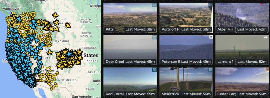
The Oregon Hazards Lab has developed and operates a high-speed camera network that gives fire managers new ways to detect and track wildfires. Cameras are installed atop high peaks or even high-rise buildings with 360-degree views of the surrounding area. Each camera can zoom, rotate, and tilt, allowing users to monitor the landscape, smokes, fire behavior, and weather conditions in real-time, or review later through time-lapse footage. The Oregon camera network is integrated with those operated by collaborators including the University of Nevada in Reno and the University of California at San Diego, with dozens of cameras in Oregon and thousands in the Western states.
The Oregon Hazards Lab network at the University of Oregon has helped put together the largest public-facing camera system in the world.
Doug Toomey, the lab’s director, says, “The cameras are visible during the day, and you can see twenty to forty miles on a clear day. At night they go near infrared, and you can actually see much farther.”
He told KEZI that detecting smoke on the cameras is only the first step. “There’s an operations center where they’re alerted when this camera spots something.”
There are currently 45 wildfire cameras in Oregon, and the Lab plans to operate 75 across the state by late 2025. These cameras help fire managers:
Detect, locate, and confirm ignitions
Quickly scale resources up or down
Monitor fire behavior from ignition to containment
Improve local evacuations and situational awareness
The increased situational awareness available with the cameras means fire managers can confirm 911 calls by reviewing camera footage instead of dispatching personnel or aircraft for reconnaissance. Not only is this safer and less expensive, but it frees up resources that may be needed elsewhere. Fire managers can also monitor prescribed fires, and utility companies can monitor their resources during red flag conditions.
Diane Braun, a former hotshot, said she thinks the cameras would have been a valuable resource when she was on the fireline. “It would have changed the industry,” she says, “from start to finish.” Toomey adds that the cameras play a role before a fire even starts; he says the cameras help to evaluate fuels and weather conditions in the area, including winds, humidity, and other factors before fire crews even arrive.
ALERTWest cameras live feed
The network lets people monitor cameras online. Toomey said he thinks the system can help people watch fire conditions and understand the threats — and even take steps in wildfire prevention. Agencies including the Oregon Department of Forestry have access to the camera system. Jessica Neujahr with ODF said using the cameras helps them not only detect smoke, but also dispatch resources faster and get a preview of the landscape they’re heading into.
==> WATCH LIVE CAMERA FEEDS HERE <==
The detection cameras are powered by ALERTWest, a technology platform from DigitalPath. This platform uses artificial intelligence to enable rapid wildfire detection. AI technology pulls the camera feeds from cloud servers and scans images for ignitions using detection algorithms and then can alert dispatch centers. Dispatchers then confirm the detection before alerting responding agencies. Fire managers in Oregon will begin receiving the automated alerts during the 2024 season.
The IAWF will hold its annual national Cohesive Wildland Fire Management Strategy Workshop in Atlantic City, New Jersey from September 16 – 19. Before that, the IAWF (in partnership with the Wildland Fire Leadership Council — WFLC) is asking people to submit recipes for the upcoming “Cohesive Strategy Cookbook” that will be ready in time for the workshop.
But hurry up! Deadline is June 7 and those who submit recipes should provide the following:
Name of recipe
Ingredients with measurements
Step-by-step directions
Prep time, cook time, and total time
Number of servings
Photo of the prepared dish
The association also asks contributors to share the source of recipes if they aren’t original, e.g. Betty Crocker recipes.
Anyone who has been in a fire camp knows firefighters don’t have the privilege of gourmet-level meals. On the contrary, the USFS has received numerous requests to update and elevate firefighters’ food supply. University of Idaho researchers, for example, analyzed standard USFS food vendor menus for fire camps and found that most did not meet firefighters’ nutritional needs, including deficits of micro-nutrients, meals lacking electrolyte balances, and only minimal variety.
“We expect vendors to provide a variety of healthy options during fire season, but along with that firefighters need to understand that making healthier choices can have an impact on their performance,” researcher Heidi Holubetz said.
The USFS is expected to pass along the requests to their contract caterers with the hope of making menu modifications for the 2025 contracts. Down the road, researchers hope they can work directly with vendors for future menu updates.
Smoke from a wildfire that’s burned more than 4,000 acres and forced thousands to evacuate is causing 2024’s first widespread drop in air quality, according to the British Columbia Wildfire Service.
The Parker Lake Fire, burning in the northeast section of the province, forced more than 3,000 residents from the nearby Northern Rockies Regional Municipality and Fort Nelson First Nation to evacuate.
BC smoke drift from Parker Lake Fire
“All remaining residents are urged to evacuate the community immediately,” a press release from the Northern Rockies Regional Municipality said. “As the safety of emergency personnel remaining in the community becomes the priority, residents remaining in place need to be aware that emergency medical services are not available, nor are groceries or other amenities. Utilities may be affected to support fire response efforts.”
While the evacuations are limited to the immediate areas near the wildfire, the smoke is triggering air quality alerts throughout Canada and the northern U.S., according to Canada’s Weather Information Service and the AirNow Fire & Smoke Map.
Air quality is at the most dangerous reading of “hazardous” in areas directly southeast of the fire near the community of Grande Prairie. People should avoid outdoor activities during hazardous air quality, especially people with pre-existing heart or lung conditions, or older adults, children, and pregnant women.
The smoke has caused “very unhealthy” air quality alerts in numerous communities in central and southern Alberta. Communities in southern Saskatchewan, Manitoba, and Ontario, as well as areas in Montana, North Dakota, and Minnesota have “unhealthy” air quality.
The Parker Lake Fire is the first wildfire of 2024 to cause widespread air quality impacts, the beginning of what fire experts expect to be a growing trend throughout the year. Fire crews throughout British Columbia are actively fighting 134 wildfires, primarily in the Prince George region of the province, according to the province’s wildfire service.
Most of the fires are considered “under control,” with only four wildfires designated as “being held” and 13 others “out of control.” Another 102 BC fires have started since the beginning of the year, but are considered “out.”
Canada’s early and busy start is on par with the fire service’s outlook for the spring 2024 season that was released in March. “The current long-range forecasts suggest a high potential for an active spring wildfire season in British Columbia,” the report says. “While recent snowfall may seem beneficial, its impact on the upcoming wildfire season is expected to be minimal due to sublimation (solid to vapor) and the dry nature of snow in Interior regions. The low snowpack will limit surface runoff, stream flows, and fuel moisture recharge, which could limit drought recovery into summer 2024.”
The intensity of the summer wildfire season is in British Columbia largely depends on the amount and duration of rainfall during May and June, the rainiest months in the BC Interior. Continuous rain could reduce the likelihood of wildfires, but meteorologists are currently skeptical that sufficient rainfall will occur.
The 2023 wildfire season in British Columbia ended with 2,293 wildfires and burned more than 7 million acres, costing the province $1.1 billion. Just over 70 percent of the wildfires were lightning-caused.
which is just one of over 100 active fires in Canada,
Fire science researchers at Oregon State University launched a new project on May 10 to study how embers from homes and other buildings spread to nearby structures. “Our motto is burn to learn,” said OSU full-time research assistant Adarsh Verma. “So we are burning stuff to learn more about fire and how it’s going to spread.”
From May 10 to 16, the research team will burn outbuildings in a field and examine the effects that structures of different sizes have on the firebrands — the embers and coals produced by a fire. They’ll analyze the numbers of embers produced, the distances they’re lofted on the breeze, and embers’ potential for new starts on adjacent buildings or other fuels.
Research assistant Jonathan Carter told Albert James with KEZI-TV that researchers are tracking the number of embers generated by flames and how hot embers get. Firebrands must hit a minimum temperature before ignition occurs in adjacent fuels.
The project kicked off on Friday, and the research team members hope to learn from the experience for future planning. “As we increase the size of the structure, the number of embers and their spread will increase,” Sharma said. “They will spread over larger areas and the number of firebrands will increase.” He said their results could guide structure design in residential areas. He hopes to look into additional factors that could affect fire behavior, including wind and home building materials.
The KEZI broadcast with Albert’s video is online [HERE].
Fire science researchers at Oregon State University launched a new project on May 10 to study how embers from homes and other buildings spread to nearby structures. “Our motto is burn to learn,” said OSU full-time research assistant Adarsh Verma. “So we are burning stuff to learn more about fire and how it’s going to spread.”
UPDATE: Zach Garland, the state firefighter injured Thursday on a Kentucky wildfire, is now in stable condition at the burn center in Huntington, West Virginia. On April 25 the Pike County 2 Crew was working a wildfire when the fire shifted; Zach was trapped and burned and critically injured. He was building fireline when fire cut off his escape route. Crew members immediately called for EMS; Zach was flown to the burn center at Huntington, where he is in good spirits. Though he is medically stable, he faces a very long road to recovery; Zach suffered second- and third-degree burns to his face, arms, hands, and knees.
Zach Garland in the burn center at Huntington, West Virginia
His friend and co-worker Trey Beam has started a GoFundMe page to help with medical expenses. “Zach was protecting our Kentucky land,” writes Trey, “as well as wild horses, homes, and civilians. Zach is a dad to two young children, the youngest of whom was born on the day after Zach was injured. We are requesting contributions of any size, to assist with out-of-pocket expenses for medical bills, travel, lodging, and Zach’s lost wages. Zach and his family face a very long road ahead.”
Zach’s unexpected expenses. If you have another $20 in your pocket, he
and his wife need it more than you do — and May the 4th be with you.
Kentucky firefighters Teena Dunn and Zach Garland.
PUBLISHED 27. APRIL 2024 — On Thursday about a mile south of Stopover in Pike County, Kentucky, the Blankenship Hollow Fire early in the afternoon injured a firefighter in a burnover incident. A structure fire in Blankenship Hollow escaped into the woodland and was reported to the Hazard Branch forestry office; volunteer fire departments at the incident requested a forestry crew to assist. The Forest Ranger IC type 5 and a Pike County crew were dispatched just before 2 p.m. and arrived at 3 p.m.
Kentucky firesZach Garland running firing on a burnout operation.
Initial size-up from the IC was 10 acres burning in timber with an uphill run and high spread potential.
The IC reported that several additional structures near the fire would be their initial focus.
About 45 minutes later with structure protection completed, the IC and the crew hiked up the mountain to engage the head of the fire directly. They said they had active behavior with short-range spotting and decided to wait for a break before engaging.
Blower line on the Blankenship Hollow Fire near the site of shelter deployment. The area is hardwood leaf litter — as was 90 percent of the burn area. The area around the deployment zone was 60-100 ft hardwood with 3-12 ft beech, maple, and mountain laurel understory.
At 5:15 the IC reported a break in fire behavior and they re-engaged with direct handline construction. Firefighters began building line down both flanks and at 5:55 IC reported that a firefighter had become trapped by a spot fire, cutting him off. He said he was deploying a shelter; 3 minutes later the IC reached the crew member and began a medical assessment. Kentucky State Police out of Pikeville was contacted by dispatch; they sent EMS units and requested a life-flight medical helicopter be held on standby.
The IC and the fire crew were able to assist the injured firefighter, who walked mainly under his own power off the mountain to the waiting ambulance, where EMTs decided to request helicopter transport to the burn unit at Cabell Huntington Hospital in Huntington, West Virginia. There were no reports of other injuries.
The burned firefighter is in stable condition at the burn center this evening and is in good spirits. He endured burns on the hands, knees, and face; there will be a 72-hour followup report.
A statewide burn ban is in effect through the end of this month.