THIS ARTICLE IS NO LONGER BEING UPDATED. Since it was becoming lengthy, we began a fresh one Sunday morning, August 2, 2015.
(UPDATED at 9 a.m. PT, August 1, 2015)
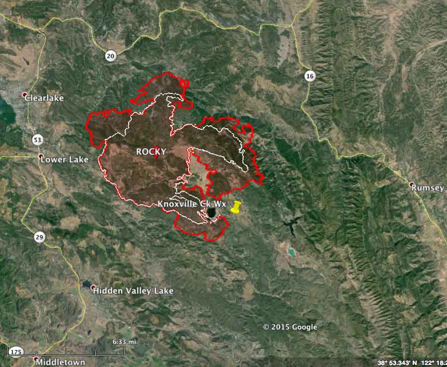
The Rocky Fire three miles east of Clearlake, California continued to expand Friday in almost all areas except for the southwest side. Friday night it was within 2.3 miles of the outskirts of Clearlake and 2 miles of Highway 20.
CAL FIRE reports that it has burned 22,500 acres.
Mandatory evacuations are in effect for Jerusalem Valley area east of Soda Creek, Bonham Road, Quarter Horse Lane, Mustang Court, Bronco Court, Sunset Court, Morgan Valley east of Bonham Road, Canyon Road, June Bug Road, Cambell Ranch Road, Sloan Ranch Road, Sky High Ranch Road, Rocky Creek Road, and Dam Road from the gate to the dam.
An Evacuation Advisory has been issued for the City of Clear Lake impacting 5000 residences
A chance of thunderstorms, cooler temperatures, and higher humidity are in the forecast for Saturday.
The fire is being battled by 1,951 personnel, 160 fire engines, 28 hand crews, 19 helicopters, and 46 dozers. The number of air tankers varies throughout the day.
****
(UPDATED at 8:55 p.m. PT, July 31, 2015)
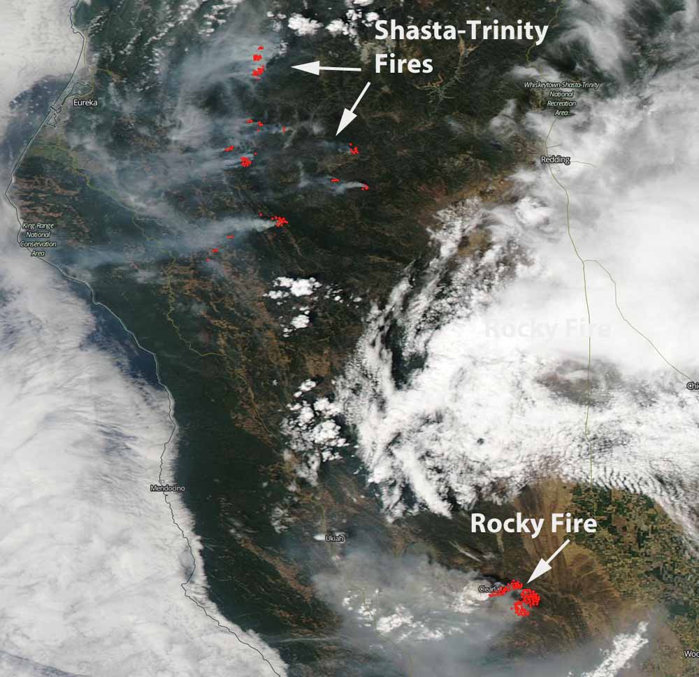
The wind controlling the direction of spread of the Rocky Fire east of Clearlake, CA changed to coming out of the northeast on Friday between 7 a.m. and 3 p.m. This has pushed the smoke and some of the hottest portions of the fire to the west in the direction of the communities of Clearlake, Lower Lake, and Twin Lake. Below is an update from CAL FIRE at 5:45 p.m. on Friday:
New – The Rocky Fire has progressed and is currently moving southwest towards Lower Lake and the eastside of Clearlake. The Lake County Sheriff’s Office along with the Clearlake Police Department have issued an advisory evacuation of all areas east of Highway 29 starting at Riata Road to the Highway 53 junction. As well as all areas east of Highway 53 north to Highway 20 and Ogulin Canyon Road. An evacuation advisory is not a mandatory evacuation but it is strongly recommended. Residents are advised to gather their medications, pets and important papers. Residents should be prepared to leave the area with little notice. If residents are evacuated they may seek shelter at the Middletown High School or the Kelseyville High School.
Mandatory Evacuations:
The Lake County Sheriff’s Office has issued a mandatory evacuation order for the Jerusalem Valley area east of Soda Creek, west of Soda Creek, Bonham Road, Quarter Horse Lane, Mustang Court, Bronco Court, Sunset Court and Morgan Valley Road east of Bonham Road.
The forecast calls for the east component wind to continue until noon on Saturday, after which it will change to come out of the south and then the southwest, reducing the threat for a while to the communities on Highways 29 and 53. The humidity Friday night will increase to 69 percent which should slow the fire somewhat.
****
(UPDATED at 2:16 p.m. PT, July 31, 2015)
Model Forecast of smoke plume for #RockyFire for today, July 31st. #cawx Check latest air quality .@SpareTheAir pic.twitter.com/EmMH9zW87Y
— NWS Sacramento (@NWSSacramento) July 31, 2015
The Rocky Fire 3 miles east of Clearlake, California continued its march through vegetation northwest of Sacramento, doubling in size while chewing up an additional 8,000 acres in the 25 hours after it was previously mapped. An 11 p.m. aerial mapping flight last night found that it has blackened over 16,000 acres since it started at 4:10 p.m. PT on July 29.
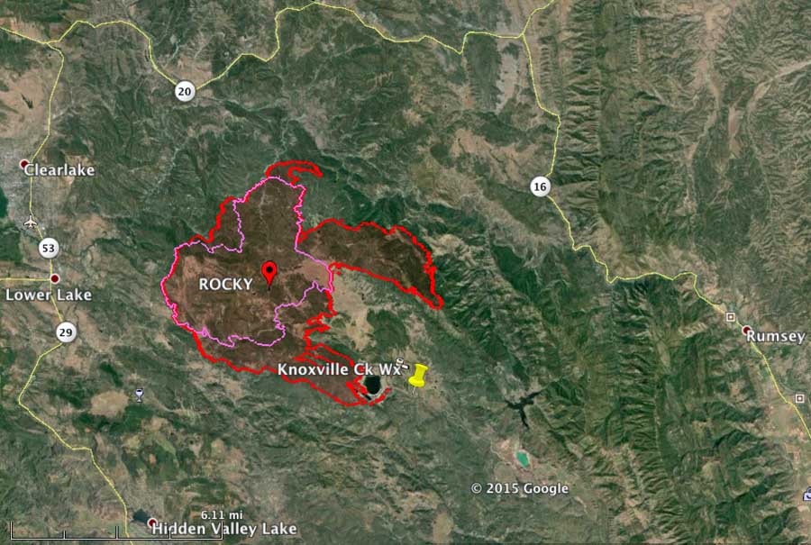
On Thursday the fire spread primarily to the east, sending out two large fingers of flames that were three and four miles long. An evacuation advisory has been issued for the Double Eagle Ranch and homes along the Highway 20 corridor between New Long Valley Rd. and east to the county line. Evacuations are still in effect for the area north of Morgan Valley and east of Bonham Rd, Jerusalem Grade Rd, Spruce Grove Rd (north end), Noble Ranch Rd and Cantwell Ranch Rd. The fire is being battled by 988 personnel, 151 engines, 32 hand crews, 8 air tankers, 8 helicopters, and 30 dozers.
#RockyFire during #BlueMoon over #Clearlake #Ca pic.twitter.com/L4GzgQ7OtT — Jeff Frost (@Jeff_Frost) July 31, 2015
****
(Originally published at 9:41 a.m. PT, July 30, 2015; updated at 4 p.m. July 30, 2015)
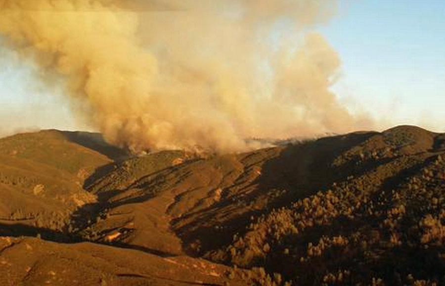
The Rocky Fire grew to over 8,000 acres within six hours of starting at 4:10 p.m. PT on July 29, according to data collected during a mapping flight at 10 p.m. on Wednesday. As you can see on the map of the fire below, by 10 p.m. it had spread to within 3 miles of the community of Clearlake, California. It is 51 miles northwest of Sacramento. By 11:15 a.m. CAL FIRE said it had burned 8,300 acres. The very rapid spread was encouraged by single-digit humidity and triple-digit temperature, 7 percent and 102 degrees as recorded at a weather station 3 miles southeast of the fire. The forecast is for similar conditions on Thursday, 103 degrees and 12 percent humidity. The wind will be at 7 mph, from the northeast in the morning switching to the south in the afternoon.
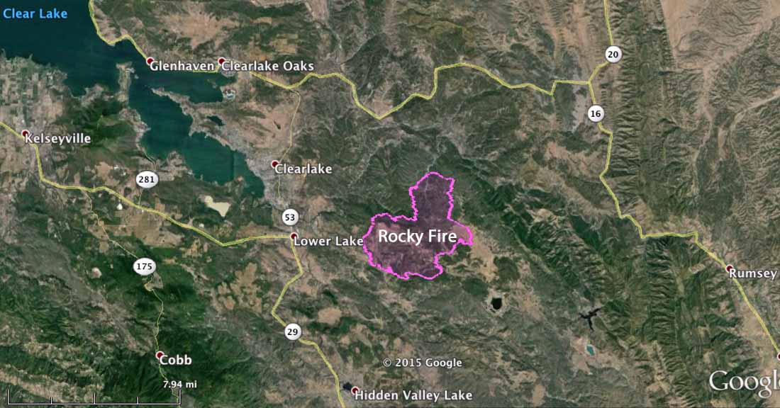
The Rocky Fire was active all Wednesday night, according to an analysis of the weather by Chip Redmond. A large convection column of smoke was easily detected by radar.

At 7 a.m. on Thursday, CAL FIRE said evacuations were in place for the north side of Morgan Valley Road for 5 miles east of Bonham Road. And, south of Lower Lake, evacuations were in place at Spruce Grove Road. To the north, Noble Ranch, Jerusalem Grade, and Cantwell Ranch were on the list. CAL FIRE reported, “Three structures destroyed. Multiple outbuildings destroyed/damaged”. An evacuation center is open at the Highland Senior Center, 3245 Bowers Road, Clearlake.
@joesuarez0 here’s your crew firing out for structure defense last night #rockyfire pic.twitter.com/gfNXFYkPtt
— Stuart Palley (@stuartpalley) July 30, 2015

MY THOUGHTS/PRAYER ARE w ALL OF THE FAMILY/SURVIVORS OF THE CAPTAIN FIREFIGHTER FROM SO. DAKOTA. BLESS U ALL AND THE CAPTAIN! ijcorona
Here’s what I know…..when I see the new Cal-Fire DC-10 #910 over my place like I have the last two days, I feel good about paying my taxes. Real good.
Marjorie – see http://yubanet.com/2015CA/Rocky.php – they update every couple of hours w/ the evacs
Please keep me up to date.
From the scanner, “it’s spotting everywhere” … nasty
18,000 acres @ ~2:20pm PT
Thanks for having a perimeter map showing progress and direction of rocky fire.
You’re very welcome 🙂
I’m from this area and this was the most helpful visual to be found (the perimeter map, showing the growth of the Rocky Fire and the direction it was headed). Please keep us updated. I shared this map on FB, crediting this site & there were another 130 shares from that post. Keep up the most excellent work!
This reminds me a little of the High Park Fire, think that was 20,000 acres by day 2 – or it might have much more …