747 Supertanker slated to return to service

The retardant delivery system has a new owner

5:11 p.m. PDT Sept. 3, 2021

Global Supertanker Retardant Delivery System
Global Supertanker Retardant Delivery System. Image by Global Supertanker.

A company that provides aircraft for lease has purchased the retardant delivery system (RDS) formerly in the 747 Supertanker. Logistic Air is now the owner of the tanking system that for years had interim approval by the federal government’s Interagency Airtanker Board (IAB) to be used in an air tanker.

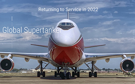
Global Supertanker’s recently modified  website proudly proclaims “Returning to Service in 2022.”

Global Supertanker
Screengrab from GlobalSupertanker.biz Sept. 3, 2021.

Many of the photos of aircraft on Logistic Air’s website are 747s, but they provide wide-body and narrow-body passenger and cargo aircraft for world-wide operations.

Fluid tanks 747 supertanker
The eight fluid tanks were inspected, tested, painted, and mounted to cargo pallets before being installed in the last version of the Supertanker in 2016. Photo by Global Supertanker.

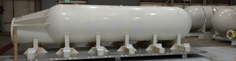
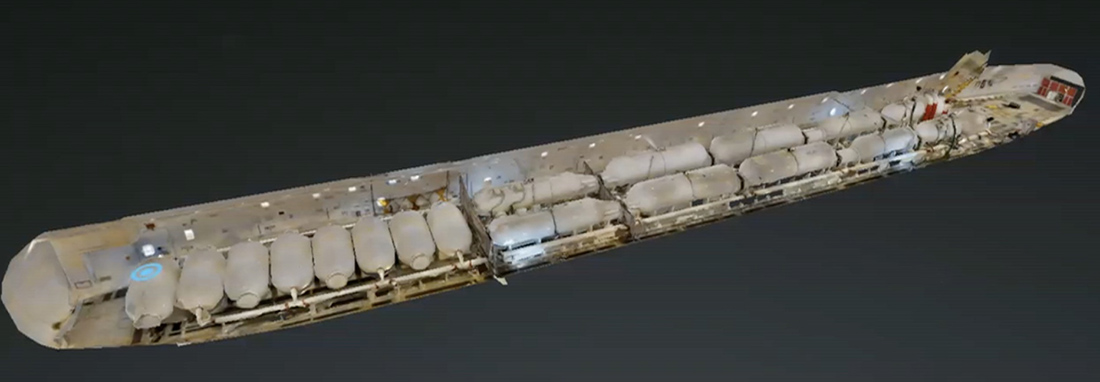
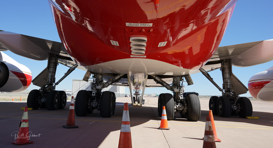
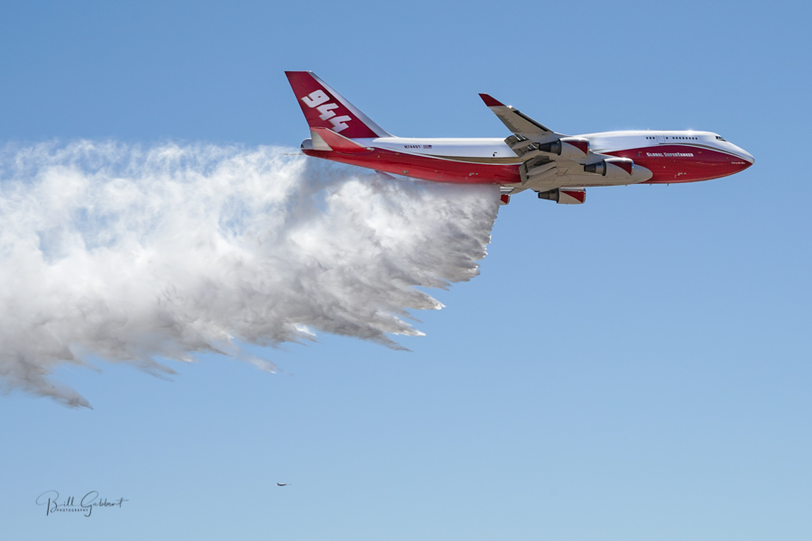
The SuperTanker’s RDS is comprised of approximately 20 tanks that hold retardant and enough compressed air to pump the retardant out of the four nozzles that were in the belly of the huge aircraft. At various times the air tanker had interim certification by the IAB to carry 20,000, 19,200 and 17,500 gallons of retardant. The IAB and the US Forest Service appeared to bend over backwards to find reasons to not issue full approval to the aircraft and the RDS.

Supertanker's nozzels
Retardant comes out of four nozzles on the belly of the Supertanker. Photo by Bill Gabbert.

Earlier this year the SuperTanker’s drop controlling system and other components were significantly modified to improve the delivery of retardant, including metering the volume dispersed based on the ground speed of the aircraft. It then went through dozens of tests on the ground. The operators were waiting for it to be scheduled for the IAB’s grid or cup test which measures the amount of retardant that hits the ground over a large grid. But before that took place, the owner, Alterna Capital, shut down the company and sold the aircraft and the RDS to two companies. The 747 was purchased by National Airlines to be used as a freighter, and Logistic Air bought the RDS.

747 SuperTanker makes demonstration water drop
747 SuperTanker makes demonstration water drop in Colorado Springs, May 14, 2016. Photo by Bill Gabbert.

A person at Alterna Capital who was not authorized to speak for the company told Fire Aviation that Global Supertanker had approximately two dozen employees and contractors when the doors closed and none of them are working for the new owners at this time. The person said Alterna “will support Logistic Air in any way we can.”

Calls to Logistic Air were not immediately returned.

UPDATE at 6:27 p.m. PDT Sept. 3, 2021

After this was published we received a call from a person at Logistic Air who asked to remain anonymous. They confirmed that the company plans to install the RDS in a nose-loading 747-200 when the aircraft completes maintenance after the first of the year. The aircraft itself will have to be modified, of course, to enable loading retardant and compressed air, and the plumbing and belly nozzles need to be installed. Then they will schedule a grid test, which they are confident it will pass. The final and most important step is applying for and receiving a new contract from the US Forest Service, no easy feat. We were told that some of the former employees of GlobalSupertanker are expected to work with the new organization.

747 Palmer Fire supertanker
Air Tanker 944, a 747-400, drops near structures on the Palmer Fire south of Yucaipa, California at 4:25 p.m. PDT September 2, 2017. Photo by Leroy Leggitt, used with permission.

Thanks and a tip of the hat go out to Rick.

BLM to convert hundreds of seasonal forestry technicians who fight fire to permanent positions

BLM engine crew members
BLM engine crew members mopping up on the BLM Trout Springs Prescribed Fire in southwest Idaho, Sept. 13, 2019. BLM photo.

The Bureau of Land Management is implementing direction from Congress to convert hundreds of their employees who fight wildland fires from seasonal to permanent status. Most of the federal government’s wildland firefighters are inappropriately in positions titled Forestry Technician or Range Technician.

Historically, the BLM’s wildland fire workforce was seasonally based. However, a new model is intended to address the escalating workforce needs due to climate change intensifying fire activity. In a news release the BLM said this model will also provide employees with career stability and upward mobility to promote work-life balance and long-term careers in wildfire or resource management.

The BLM received $13 million in its 2021 fiscal year budget which began October 1, 2020 to begin workforce transformation, which involves adding 76 new firefighters and support personnel who sustain the wildland fire management mission. The BLM will also convert 428 existing seasonal positions to permanent and/or year-round positions. Overall, the U.S. Department of the Interior received $29 million to carry out “DOI’s Plan to Transform the Firefighting Workforce.”

Other agencies in the DOI with wildland firefighting responsibilities are National Park Service, Fish and Wildlife Service, and Bureau of Indian Affairs. The US Forest Service also has thousands of Forestry Technicians whose primary jobs are fighting fire, with many of them being seasonal. All five of the agencies were directed by Congress to convert some of their seasonals to permanent and/or year-round.

“The ultimate goal of workforce transformation is to attract and retain a diverse group of quality employees – dedicated people who will not only help manage fires and fuels in support of BLM’s multiple-use mission, but who have the potential to become the Bureau’s future leaders,” said BLM Deputy Director of Policy and Programs Nada Culver. “Our people are our most important resource, and this workforce transformation effort will result in more career opportunities and benefits for our wildland firefighters – those who work hard to keep the public safe and to protect our public lands.”

The BLM Fire program is planning to continue this transformation effort next fiscal year and beyond in hopes of fully transforming its workforce in the coming years.

“The fire activity we’ve experienced in 2021 and previous years reinforces the need for transforming a sizeable portion of our largely seasonal fire organization to permanent positions, though widespread change will not happen overnight,”said BLM Assistant Director of Fire and Aviation Grant Beebe.

Thanks and a tip of the hat go out to Rick.

Firefighters work to secure the Caldor Fire near South Lake Tahoe

Friday the wind will generally be light, but on some ridge tops will be from a different direction, east-southeast with 20 mph gusts

10:28 a.m. PDT Sept. 3, 2021

Caldor Fire strike team engines
Two strike teams of engines, including 9271C, preparing for their shift on the Caldor Fire Sept. 3, 2021. CAL FIRE Amador-El Dorado Unit photo.

The Incident Management Team reports that weather on the 212,000-acre Caldor Fire near South Lake Tahoe continued to moderate Thursday and Thursday night with cooler temperatures in the 70’s during the day with lighter southwest winds. Fire growth was minimal, increasing by about 2,000 acres. In an indication of what kind of fire behavior they had been facing for weeks, Thursday night the Fire Behavior Analyst called it good news that the spotting distance has decreased from one mile to a half mile.

At the head of the 8,000-acre finger of fire east of Highway 89 near Trimmer Peak south of South Lake Tahoe, hotshot crews were successful in extinguishing fire around numerous hot spots. Dozers and hand crews are putting in direct and indirect line on the south side of that finger. Crews are also putting in dozer line on the north side, in some places tying it in with power line rights of way.

To see all articles about the Caldor Fire on Wildfire Today, including the most recent, click HERE.

On the south side of the fire west of Kirkwood dozers and hand crews have completed a line around the south edge of the 800-acre slop over south of Highway 88, northwest of the ski area. They are installing a hose lay to keep it secure and to mop up.

Today, Friday, the inversion will break around 10 a.m. when fire behavior may begin to increase. Relative humidity is expected to be in the teens, and winds will generally be light except on ridges where they could be from the east-southeast with gusts to 20 mph. This major shift in the wind direction could test some constructed firelines in a way they have not been in recent days. Exceptionally dry fuel conditions exist in the fire area.

In a live briefing Thursday night Sept. 3 East Side Incident Commander Rocky Oplinger complimented the agencies for the fuel treatments that have been accomplished over the years. He said the 150-foot flame lengths dropped to about 15-feet when the fire entered the treated areas. This allowed hand crews and engines to take an aggressive approach to suppress the fire and prevent structure loss. The video of the briefing is on Facebook; Mr. Oplinger’s comments about the fuel treatments begin at 34:10.

The number of residences destroyed, 661, is an increase of 39 since Thursday; 196 other structures have also burned. Fire officials are maintaining a map that shows structures which have been evaluated for damage.


3:52 p.m. PDT Sept. 2, 20212

Caldor Fire 3-D map, northeast side, 11:13 a.m. Sept. 2, 2021
Caldor Fire 3-D map, northeast side, 11:13 a.m. Sept. 2, 2021.

The movement of the Caldor Fire has slowed in recent days as the wind decreased and as portions of the fire moved into high elevations or areas where there is more granite than vegetation.

On the northeast side of the fire east of Highway 89 dozers have been building line on the north side, the flank closest to South Lake Tahoe. Night Operations Section Chief Craig Dougherty said Thursday morning a large portion of that flank now has fireline. On Wednesday and Wednesday night four structure protection groups were working in that area mopping up and securing the edge of the fire.

The south side of that large finger of fire is active with a backing fire

The fire is still about the same distance from the shore of Lake Tahoe, about 4 miles, and it is 3 miles from the Nevada state line. The head, or the far northeast area, has spread uphill above 9,000 feet, where the sub-alpine vegetation should act to slow the movement, but spotting at times keeps it moving.

Caldor Fire map
Caldor Fire map, 11:13 a.m. Sept. 2, 2021.

Fire officials are maintaining a map that shows structures which have been evaluated for damage. To date, crews have confirmed that 622 residences and 189 other structures have been destroyed.

Wednesday evening 4,451 personnel were committed to the fire which was mapped Wednesday night at 210,000 acres.

Caldor Fire map
Caldor Fire map, northeast side, 11:13 a.m. Sept. 2, 2021.

PBS explains how fire whirls and fire tornados form

PBS Weathered Firenado
Still image from PBS Weathered. “Firenado: when two of nature’s deadliest forces combine.”

PBS has published a 10-minute video (below) about how fire whirls and fire tornados form. Here is how they summarize it:

A fire tornado, or “firenado,” is exactly what it sounds like: a tornado made out of fire… and it is truly the stuff of nightmares. The most famous example occurred when the 2018 Carr Fire spawned an EF3 fire tornado with estimated wind speeds of 143 mph! And as climate change drives increasing wildfires around the planet, it only makes sense that we see more fire tornadoes as well.

Tune into this episode of Weathered to learn what the latest science can tell us about these rare but dangerous phenomena as well as about the surprising ability of burnt forests to store carbon and mitigate climate change.

Weathered is a show hosted by meteorologist Maiya May and produced by Balance Media that helps explain the most common natural disasters, what causes them, how they’re changing, and what we can do to prepare.

Fire whirls, much like dust devils, are not uncommon on a fire when the atmosphere is unstable, and are much smaller than fire tornados. In 1978 a researcher for the National Weather Service in Missoula, David W. Goens, established parameters for the two.

He said the average size of a fire whirl is usually 33 to 100 feet, with rotational velocities of 22 to 67 MPH.

But a fire tornado dominates the large scale fire dynamics. They lead to extreme hazard and control problems. In size, they average 100 to 1,000 feet in diameter and have rotational velocities up to 90 MPH.

Dixie Fire makes another advance toward Highway 395

The fire was mapped Wednesday night at 859,000 acres

8:55 a.m. PDT Sept. 2, 2021

Map of the southeast side of the Dixie Fire, 3-D map at 7:30 p.m. Sept. 1, 2021
Map of the southeast side of the Dixie Fire, 3-D map looking northwest at 7:30 p.m. Sept. 1, 2021, showing the escarpment above Highway 395. The blue areas are previous fires.

The southeast side of the Dixie Fire grew substantially to the northeast Wednesday pushed by 10 mph winds gusting up to 20 mph while the relative humidity was in the single digits. During a 7:30 mapping flight Wednesday night it was 2 miles west of Highway 395, threatening to cross the road again. There is already a 5 mile-long fire scar where it reached the highway a few weeks ago, crossing it in several places near Honey Lake south of Buntingville.

The fire is approaching the edge of the escarpment where the terrain drops rapidly 2,500 feet down to Highway 395, seen on the 3-D map above. Firefighting on that steep slope would be very difficult.

Dixie Fire map, southeast side, 7:30 p.m. Sept. 1, 2021

“It’s almost to the escarpment now,” said CAL FIRE Operations Section Chief Tony Brownell. “We’ve moved a lot of engines and personnel around, we are down around 395, concentrating on structure protection. So when it does come off that hill we are going to be there to catch it and keep it out of structures the best we can.”

To see all articles on Wildfire Today about the Dixie Fire, including the most recent, click HERE.

The fire has also reached the north edge of Lake Davis eight miles north of Portola which is on Highway 70.

The extreme fire behavior witnessed Wednesday is predicted to continue due to persistent winds and dry fuel conditions — near red flag warning criteria. The forecast for Thursday is for 7 to 13 mph winds out of the west-southwest gusting late in the afternoon up to 21 mph with the relative humidity in the teens.

Dixie Fire map, 7:30 p.m. Sept. 1, 2021.
Dixie Fire map, 7:30 p.m. Sept. 1, 2021. The blue areas are previous fires.

On the northeast side, which is still active about a mile south of Highway 44, approximately half of Lassen Volcanic National Park has burned.

The fire was mapped Wednesday night at 859,000 acres. At least 696 residences and 586 other structures have been confirmed as destroyed. Suppression costs have reached $432 million since it started near a PG&E power line July 14. Wednesday evening 4,039 personnel were committed to the incident.

Wildfire potential in September expected to remain above normal in parts of the Northwest

Predicted to be above normal in Northern California through November

Wildfire potential September

The forecast for wildland fire potential issued September 1 by the National Interagency Fire Center predicts that the potential for wildfires in Northern California will be above normal September through November. Northern Minnesota and the northwest one-quarter of the country  will also be above normal in September. Hawaii and Wyoming could be busy in September and October. The southeast Atlantic coast states may experience above normal fire activity in October and November, but December looks to be pretty average in all 50 states.

The data from NIFC shown here represents the cumulative forecasts of the ten Geographic Area Predictive Services Units and the National Predictive Services Unit.

Below:

  • An excerpt from the NIFC narrative report for the next several months;
  • Additional NIFC monthly graphical outlooks;
  • NOAA’s three-month temperature and precipitation forecasts;
  • Drought Monitor;
  • Keetch-Byram Drought Index.

“Climate outlooks indicate warmer than normal conditions are likely for much of CONUS through fall. Wetter than average conditions are likely across western Washington for the fall with below normal precipitation likely across the Southwest, Great Basin, central Rockies, and much of the Plains. The Southeast is forecast to have near normal precipitation through October but turn drier in late fall and early winter.

“Much of Southern Area and areas south of the Ohio River are likely to have below normal significant fire potential in September, but much of the southeast US and Mid-Atlantic is forecast to have above normal fire potential in October and November. Normal significant fire potential is forecast for Alaska along with most of Eastern Area through the period. The entire US is forecast to have normal fire potential in December.

“Above normal significant fire potential is forecast to continue for September across much of the Northwest and portions of the Great Basin, Northern Rockies, and Rocky Mountain Geographic Areas. Most of these areas will return to normal fire potential in October and November except for portions of Wyoming, northwest Colorado, and the Black Hills, which will remain above normal into October. Much of northern California is forecast to have above normal potential through November with leeside locations in Hawaii likely to have above normal significant fire potential into October.”


Wildfire potential October

Continue reading “Wildfire potential in September expected to remain above normal in parts of the Northwest”