Update on Yosemite’s Big Meadow fire

Yosemite National Park’s escaped prescribed fire, the Big Meadow fire,

…got out of control when one cedar tree took off and cast embers into a lot of dry fuel,” spokesman Gary Wuchner said. “Then the winds changed direction, to the west, and the fire crossed Big Oak Flat and Foresta roads.”

The Big Meadow fire as seen from the Wawona road tunnel, Thursday afternoon. Photo: Maggie Beck

The park says the fire has now burned 2,244 acres, up from the 2,200 reported yesterday.

From the Union Democrat:

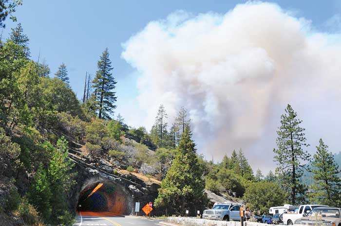
On Thursday, turnouts along Wawona Road were jammed with tourists observing the fire’s rapid spread across the stumpy forest and the vibrant cloud of smoke hovering over it.

“It’s exciting but sad,” said Laurie Larson, of San Pedro. “You don’t want to see a controlled burn get out of control.”

Sharon Griffiths, visiting from Reading, Pa., was atop Half Dome watching the prescribed burn begin to get out of control on Wednesday.

“You could see the smoke beginning to really come off the fire,” she said.

Resources from across the state have shifted to the blaze as quickly as it has grown. As of Thursday, 500 firefighters, three helicopters, four air tankers and 24 fire engines were fighting the flames.

Included in the personnel is an interagency team headed by Stanislaus National Forest Division Chief Alan Johnson. Forest Service Hotshot crews from all over the state are fighting the blaze.

On Thursday, air tankers were disappearing into the cloud of smoke to make fire-retardant drops on the fire. Simultaneously, helicopters, sucking water from the Merced River near El Portal, made water drops on the perimeter of the fire. Dozers cut fire lines along the fire’s southern edge.

The smoke seemed to be blowing away from Yosemite Valley, which was relatively clear considering the growing blaze bordering it. Late in the day, along El Portal Road just outside of the valley, the landscape had a golden hue from the blanketing smoke.

Wuchner said, unfortunately, hindsight is not a tool the fire crews can use to douse the flames.

“We are trying to take advantage of not having very many fires in the state,” he said of the large force congregating to extinguish the fire.

Mymotherload.com put together some time-lapse images of the fire:

(THE VIDEO IS NO LONGER AVAILABLE)

UAV used for Alaska wildfire

Here is a video of an unmanned aerial vehicle being used to gather intelligence about a fire in Alaska.

(THE VIDEO IS NO LONGER AVAILABLE)

From Wired.com:

Earlier this month in Alaska, a 40-pound Insitu Scan Eagle saw duty fighting wildfires after dense haze grounded conventional aircraft. The UAV is operated by the University of Alaska, which according to university officials is the first entity other than NASA or the Department of Homeland Security allowed to fly an unmanned aircraft beyond the line of sight in civil airspace.

The Scan Eagle — which is Boeing’s best-selling aircraft right now — was able to fly low over the fires through the thick smoke. Infrared cameras allowed people on the ground tracking the fires to find hotspots and monitor the fire lines.


Air tanker crashes in Greece, killing pilot

From Reuters:

A Greek fire-fighting plane crashed while battling a blaze on the Ionian Sea island of Kefalonia on Thursday, killing the pilot, authorities said.

The accident happened three days after fire fighters managed to bring under control a wildfire that destroyed 150 homes and thousands of hectares of forest and farmland near Athens.

“The death of airforce colonel Stergios Kotoulas has shattered us,” Greek President Karolos Papoulias said. “He fell at the frontline doing his duty, battling the fire.”

The 1983, Polish-made PZL plane crashed nine minutes after taking off from the Kefalonia airport to fight a forest fire, officials said. Nobody else was on board.

The 55-year-old father of two had thousands of hours of flight experience on several types of aircraft.

Our sincere condolences to the family and co-workers of colonel Kotoulas.


Escaped prescribed fire in Yosemite NP

It was planned to be a one-day, 90-acre prescribed fire in Yosemite National Park in the Big Meadow area near the community of Foresta on Wednesday, but the Big Meadow prescribed fire “jumped a holding line” and as of 6 p.m. on Wednesday it had burned 300 acres.

Big Meadow fire at 0915 Aug. 27, view from Turtleback Dome. The small smoke in the distance is the West fire on the Sierra National Forest. NPS photo

A Type 2 Incident Management Team will be assuming command. Numerous air tankers and helicopters are assigned.

Some excellent photos of the fire are on the Yosemite Blog. A web camera showing the fire that updates about every 15 minutes is HERE.

We will update this information as it becomes available.

==========================

UPDATE at 10:00 a.m. PT, August 27

The Park just posted on their web site an update written at 1 a.m.:

This fire is now an escaped prescribed fire and is being suppressed. Fire Managers estimate that 400 acres have burned.

Fire managers began the burn on the morning of August 26 and in a very short time realized the holding lines were not going to contain the fire within the boundaries of this burn. The fire began spotting across the line into pockets of brush, down and dead logs and standing dead trees (snags) to the east of the community of Foresta.

This fire is within the 1990 A-Rock fire scar. Yosemite Helicopter 551 began bucket drops, which was followed by additional aircraft resources including other water dropping helicopters, (one 3000 gal per drop, heavy helicopter), and Cal Fire fixed winged air tankers. However, aircraft resources terminate operations at night; they will resume flying in the morning. Other ground resources were ordered including additional hand crews, engines and water tenders from Mariposa County and the Stanislaus National Forest.

Crews will be working through the night. A Type 2 Incident Management Team will take over the fire on August 27.

Road Closures: The Big Oak Flat Road is closed from Highway 140 to Crane Flat and the Foresta road into the community of Foresta. There is no estimated time for the road to re-open. Highway 120 from Big Oak Flat entrance station is open to Crane Flat, on to Tuolumne Meadows, and Highway 395.

=========================

UPDATE at 10:30 a.m. PT August 27

We just talked with a fire information officer at Yosemite National Park. The fire has now burned 1,170 acres. There was some confusion about the fire name from some sources, but it is confirmed that it is named “Big Meadow”.

Crane Flat Campground and Foresta have been evacuated.

=========================

UPDATE at 6:45 p.m. PT August 27

As of 4 p.m. PT the fire has burned 2,200 acres and it is 10% contained. A Type 2 Incident Management Team will assume command of the fire today. Resources currently on the fire include approximately 500 firefighters, three helicopters, four air tankers, and 24 engines.

=====================

UPDATE at 10:27 p.m. PT August 27

McGowan’s Type 1 Incident Management Team has been mobilized for this fire.

Memorial for Robert Woodhead, helicopter pilot

From the Lillooet News

Robert Woodhead, the pilot who died on Friday, August 14 when his helicopter crashed as he was dipping water out of the Fraser River near Lytton, B.C., was remembered during a memorial service on Sunday.

Lillooet – Hundreds paid their respects Sunday at the 23 Camels Bridge to Robert Woodhead, the helicopter pilot who lost his life fighting the Intlpam wildfire.

Residents and emergency personnel joined Woodhead’s brother and four children at the afternoon tribute, which brought traffic to a standstill. Local firefighter Alain Auger and Eunice Stotesbury organized the event.

Woodhead was filling his helicopter’s water bucket from the Fraser River on Aug. 14 at about 4:20 p.m. when the craft crashed into the river. His helicopter, a Bell 212, crashed 28 kilometres north of Lytton and was headed to the Intlpam wildfire nearby.

Fire hoses spray two streams of water before helicopters fly over. Photo: Eunice Stotesbury

Another helicopter in the area tried to rescue him after the pilot saw Woodhead surface from the wreck. The other pilot lowered his bucket so Woodhead could grab hold. He could not.

His body was found in the river on Aug. 19, a kilometre south of Yale.

Though the large crowd was nearly silent and the mood was sombre, many cheered in a spectacular moment of the tribute.

Two fire hoses launched streams of water into the Fraser River from the bridge. As the hoses sprayed, three helicopters flew in a row above the river, south towards the 23 Camels. The middle helicopter carried a water bucket.

The middle helicopter released the water before reaching the bridge, prompting a shout of approval from the crowd.

The helicopters then flew over the bridge before breaking formation and turning around.

Bruce Rushton, the chaplain for the Canadian Fallen Firefighters Foundation, then played the last post and “Amazing Grace” on a trumpet.

Woodhead’s brother and children tossed flowers off the bridge into the river after Rushton played. They were followed by Lillooet Fire Department Deputy Chief David Harder, who invited the audience to release flowers and other mementoes such as poems, into the river.

Why Athens burned-again

The Wall Street Journal has an editorial about the recent fires near Athens, Greece, written by Costas Synolakis. Here is an excerpt.

ATHENS—The catastrophic fires that raged in Greece for several days and threatened Athens have scorched several of the capital’s hillside suburbs. The images are remarkably similar to those of two years ago, almost to the date. Then, the fires threatened ancient Olympia and torched Mt. Parnes, a once picturesque national park where Athenians took refuge from the summer heat and enjoyed the winter snow. The current fires have burned hundreds of homes and the forested hills that used to filter Athen’s polluted air are no more. In total, 10 major fires have burned Athenian suburbs since 1981.

There are, however, stark differences from the 2007 fires. This time, Greece immediately mobilized the European Union’s Monitoring and Information Center and 10 fire-fighting aircraft from France, Italy, Spain, Cyprus and Turkey joined the battle as quickly as typically slow intra-European logistics allowed. Despite the complexity of the disaster—with heavy winds creating fire tornadoes and hilly terrain dotted with thousands of power lines and buildings—the fires were put out relatively quickly—but at a huge cost.

Compare this with the Italian response during the L’Aquilla earthquake last spring when dozens of people might had been saved if emergency crews from neighboring countries had been allowed to help. In 2007, over 50 people died in the Greek fires, whereas no lives have so far been lost this summer. Partly this is because officials have learned their lessons. The decision to evacuate threatened areas no longer rests with the central government in Athens. Instead, local mayors—who generally followed the advice of firefighters on the ground—have been given the authority to order these emergency measures, and they successfully directed thousands to flee and escape the fires. Patients from a children’s hospital in an at-risk area were transferred well ahead of the advancing flames. For once, disaster plans were implemented as drawn.

And yet there are also stark similarities to the incompetence and mismanagement on display two years ago. There were still few or no forest roads to allow rapid access to burning mountain tops, thus necessitating aerial water drops, which are less precise and more expensive. There are still few or no hydrants in urban forests (and no trained volunteers to use them) and virtually no constant-pressure reservoirs to store water for emergency use.

Dry brush and pine needles had not been cleaned in years, while undeveloped land next to luxury homes contained enough combustible material to power entire village power plants for days. Amateurs were everywhere trying to put out fires, succeeding only in spreading them. Houses now dot high-risk land that burned just a decade ago. Urban planning and zoning is nonexistent for most of the country. Fire crews and reporters alike had trouble locating on maps the obscure names of unincorporated areas developed without permits just a few kilometers from the Acropolis.

Mr. Synolakis is a professor of natural hazards at the Technical University of Crete and director of the Tsunami Research Center at the University of Southern California.