Two air tankers collided July 30 while working on the Bishop Fire in southeast Nevada.
The Air Tractor Single Engine Air Tankers, SEATs, were involved in a mid-air collision Thursday afternoon according to Federal Aviation Administration spokeswoman Claire Morville. There was one person on board each aircraft.
At 10 p.m. MDT July 30 a spokesperson for the Bureau of Land Management, Chris Hanefeld, confirmed that the collision occurred earlier in the day at about 12:55 p.m. He said both pilots were killed in the crash. Recovery operations are currently underway and initial notifications are still being made.
“We offer our sincere condolences to the families of the two pilots and to all those working with the BLM Nevada Ely District,” said BLM Nevada State Director Jon Raby.
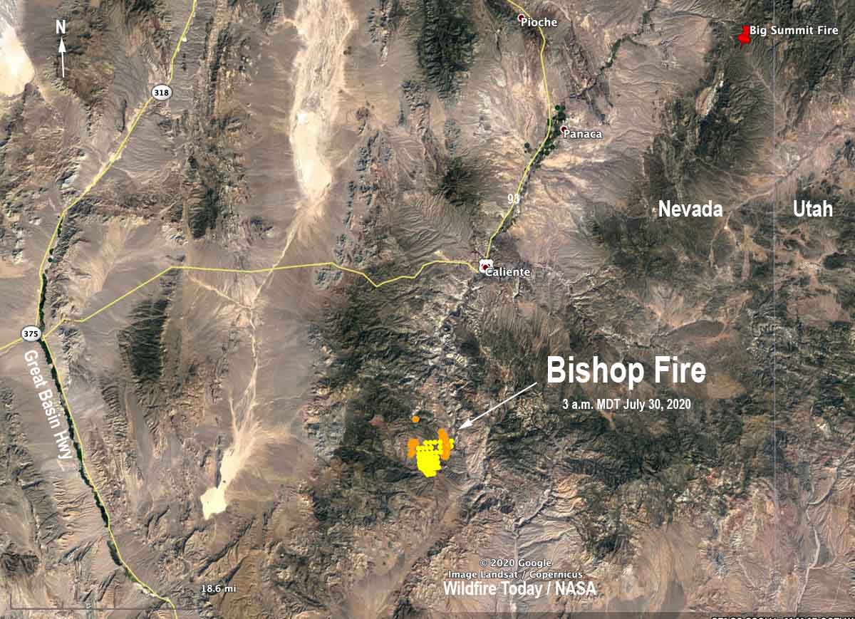
Map showing heat detected by satellites on the Bishop fire as late as 3 a.m. MDT July 30, 2020.
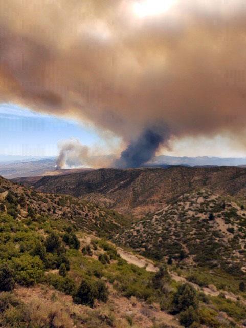
The Bishop fire, reported July 29, has burned 500 acres 14 miles south-southwest of Caliente, Nevada.
The accident occurred near the intersection of Kane Springs Road and Riggs Road, Ms. Morville said.
The fire is on land managed by the BLM. The two privately owned aircraft were under contract to the agency.
SEATs are small airplanes used to support wildland firefighters on the ground. They can deliver up to 800 gallons of fire retardant and operate in areas where larger airtankers cannot.
The names of the pilots have not been released.
Our sincere condolences go out to the pilots’ family, friends, and coworkers.
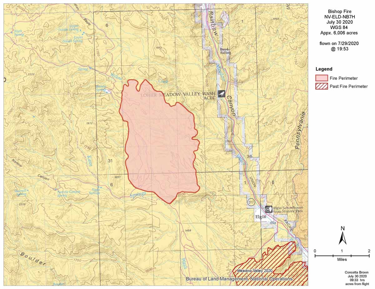
Bishop Fire map. Data from 7:53 p.m. MDT July 29, 2020. BLM.
Thanks and a tip of the hat go out to Tom. Typos or errors, report them HERE.
Caldwell Fire, on Lassen Volcanic Highway July 28, 2020. Inciweb photo.
The Caldwell Fire in northeast California was not as active Tuesday as it had been in recent days. It added an additional 1,508 acres which brought the total up to 69,297. Most of the growth was on the northwest side within or west of Lava Beds National Monument.
The area is under a Red Flag Warning Wednesday from 2 p.m. until 8 p.m.
From the Incident Management Team, July 29, 2020:
“[Tuesday] crews conducted burning operations to even out the fire’s edge and fill in unburned areas. On the west side of the fire, the 49 road is holding well. Firefighters were able to begin direct control line construction on the south side of the fire, working from the 49 road eastward. Additionally, crews are still creating secondary control lines south of the fire perimeter.
“On the southeast corner, dozers and firefighters succeeded in creating solid control line, and this allowed the residents of Tionesta to return to their homes. On the east side, fire held well along the 120 road, and fire crews built control line all around the fire area that had crossed over the railroad tracks. On the north, fire flanked into the marsh and the tule is receptive to burning, however, fire is holding well at the 120 road.”
UPDATED at 7:49 a.m. PDT July 28, 2020
Caldwell Fire. USFS photo.
The Caldwell Fire in northeast California burned across Lava Beds National Monument Monday, adding another 24,040 acres to bring the total up to 67,789 acres. This is 26 percent of the 259,823 acres burned in California wildfires in 2019.
Map of the Caldwell Fire. The red line was the perimeter at 11:17 p.m. PDT July 27, 2020. The white line was the perimeter about 24 hours before. “VC” is the location of the Visitors Center at Lava Beds National Monument.
There is no Red Flag Warning in effect for the fire area. The forecast for Tuesday calls for 87 degrees, 19 percent relative humidity, and 2 to 7 mph winds out of the southeast in the morning and west in the afternoon. On Wednesday the winds will be out of the south and stronger, 7 to 13 mph gusting up to 20 with 12 percent relative humidity.
Originally published at 2:39 p.m. PDT July 27, 2020
Map of the Caldwell Fire. The red line was the perimeter at 12:24 am PDT July 27, 2020. The white line was the perimeter about 24 hours before.
Outflow winds from a thunderstorm Sunday caused the Caldwell Fire to spread seven miles to the north, more than doubling in size. Early Sunday morning the fire was 13,125 acres, but at 12:20 a.m. Monday a fixed wing aircraft mapped it at 43,749 acres, an increase of 30,624.
(To see all articles on Wildfire Today about the Caldwell Fire, including the most recent, click here.)
As of 6:45 a.m. Monday one structure and three outbuildings were confirmed as destroyed. The fire threatened the community of Tulelake, prompting evacuations in that area. The fire has spread to approximately one mile south of County Road 120. Firefighting resources attacking the new growth included 20 engines, 5 water tenders, and 3 20-person hand crews. On the east side firefighters stopped the fire along 6 miles of a railroad, however there was one slop-over.
Caldwell Fire. NPS photo by fire lookout Ranger Wendy from Schonchin Butte July 26, 2020.
Firefighters conducted burn-out operations around the Lava Beds National Monument Visitor Center and around some residences in order to protect the facilities.
Caldwell Fire, NPS photo by Ranger C. Orland, as seen from the park’s north entrance July 26 2020.
The area is under a Red Flag Warning Monday for gusty winds and low humidity.
On Monday firefighters on the north side of the fire will prioritize protecting structures in the Tulelake area and construct both direct and indirect containment line. Crews west of the fire will continue work on the secondary containment lines between the fire and the Medicine Lake area. There are 16 helicopters available to assist with suppression efforts Monday.
In 2019 five wildfires in New South Wales merged and ultimately burned 1,071,740 hectares (2,648,323 acres)
Map of bushfires in New South Wales, showing projected spread and ember attack, Dec. 21, 2019.
The Australian Broadcasting Corporation, ABC, has put together the story of the largest bushfire in the recorded history of the continent. When the spread of the Gospers Mountain Fire finally halted during the 2019-2020 bushfire season, it had merged with four other large blazes to ultimately burn 1,071,740 hectares (2,648,323 acres).
Sometimes in the United States we call a fire that reaches 100,000 acres a “megafire”, but the prefix “mega” means a million (106). Last bushfire season the Aussies had a legitimate megafire.
The article at ABC is well researched and interesting. It includes details that previously were not widely known — such as the fact that firefighters were worried that the fire could burn into the northern suburbs of Sydney, the state capital of New South Wales.
Air Tanker 131, a C-130Q (N130FF) on the Karen Fire in San Bernardino County, CA July 26, 2020. Photo credit: CAL FIRE Riverside Co FD.
CAL FIRE and local fire departments made quick work of the Karen Fire that burned 277 acres Sunday near Fontana in southern California. It was first reported off Sierra Avenue and Karen Lane and when it was contained of the burned area was in San Bernardino County.
Karen Fire July 26, 2020. Photo credit: CAL FIRE Riverside Co FD.Air Tanker 131, a C-130Q (N130FF) on the Karen Fire in San Bernardino County, CA July 26, 2020. Photo credit: CAL FIRE Riverside Co FD.Air Tanker 131, a C-130Q (N130FF) on the Karen Fire in San Bernardino County, CA July 26, 2020. Photo credit: CAL FIRE Riverside Co FD.Karen Fire July 26, 2020. Image credit: San Bernardino Co FD.
Map showing the perimeter (in red) of the Caldwell Fire at 10:36 p.m. PDT July 26, 2020. The white line was the perimeter about 24 hours before.
A mapping flight Saturday night showed that most of the growth of the Caldwell Fire Saturday was on the northeast and west sides. It expanded by 1,265 acres to bring the total to 13,125 acres.
The forecast for Sunday is for 91 degrees, 14 percent relative humidity, and 5 to 8 mph west winds in the afternoon along with isolated showers and thunderstorms.
(To see all articles on Wildfire Today about the Caldwell Fire, including the most recent, click here.)
A Red Flag Warning is in effect for the fire area Monday for abundant lightning and dry fuels.
Originally published at 8:47 p.m. PDT July 25, 2020
Satellite imagery showing heat and smoke on the Caldwell Fire at 7:41 p.m. PDT July 25, 2020.
The Caldwell Fire in northeast California has been very active for the last two days, growing to 11,860 acres by Saturday morning and was particularly active on the northeast side Saturday. Firefighters are constructing both direct and indirect control lines to limit fire spread using existing road and trail systems. They will work from the Lava Beds National Monument Visitor Center southwest and from the 10 Road going back west toward the lava fields.
The Caldwell Fire is on the Modoc/Siskiyou county line southeast of Lava Beds National Monument and 37 miles southeast of Klamath Falls, Oregon.
Map showing the location of wildfires in northeast California at 10:47 p.m. PDT July 24, 2020.Wildfire smoke forecast for 6 a.m. MDT July 25, 2020. NOAA.
Most of the smoke was generated by the Caldwell Fire in northeast California
Wildfire smoke forecast for 6 a.m. MDT July 25, 2020. NOAA.
The map shows the forecast for the distribution of vertically integrated smoke from wildfires at 6 a.m. MDT July 26, 2020. Most of the smoke is from the Caldwell Fire in northeast California.