Perchlorate, which is now in the water at the park after fireworks shows, has been linked to fetal and infant brain damage
Mount Rushmore. Photo by Bill Gabbert.
The National Park Service is planning to conduct another fireworks show at Mount Rushmore National Memorial on July 3, 2020.
One of the reasons for prohibiting massive fireworks displays over the faces of the four presidents on Mount Rushmore National Memorial is that the previous 11 fireworks shows between 1998 and 2009 contaminated the water at the memorial. The fireworks explosions left perchlorate on the ground which has been linked to fetal and infant brain damage, and it worked its way into the water table. In 2016 a USGS report showed that a maximum perchlorate concentration of 54 micrograms per liter was measured in stream samples at Mount Rushmore between 2011 and 2015. That was about 270 times higher than in samples collected from sites outside the memorial, which were 0.2 micrograms per liter.
In recent months the Environmental Protection Agency was considering establishing a limit on perchlorate of 56 micrograms per liter, almost 4 times higher than the limit of 15 proposed by the administration in 2009, but it was never implemented. If adopted, the new limit would have been a policy statement by the administration that the extremely high perchlorate levels caused by the fireworks were acceptable, but just barely — by 2 micrograms per liter.
But the EPA announced June 18, 16 days before the scheduled July 3, 2020 fireworks show, that they will not regulate perchlorate, period. This makes it easier for the Governor of South Dakota and the President, who both pushed to resume the fireworks shows, to feel they have eliminated one of the barriers to continuing the explosions over the four faces.
The negative aspects of exploding fireworks over the sculpture, as learned from the 11 times it has been done in the past, include two other issues in addition to carcinogens in the water:
2. Garbage
The trash dropped by the exploding shells onto the Monument and the forest can never be completely picked up. Left on the ground are unexploded shells, wadding, plastic, ash, pieces of the devices, and paper; stuff that can never be totally removed in the very steep, rocky, rugged terrain.
The fire burned several acres and required a 20-person crew and a helicopter to suppress
Map showing wildfires that were caused by fireworks over Mount Rushmore in 2000 and 2001. NPS map created by Bill Gabbert October 9, 2002.
Since we are 10 days away from a large fireworks show over the sculpture on Mount Rushmore National Memorial, we should look back at fires caused by previous fireworks shows at the Memorial.
I was the Fire Management Officer for Mount Rushmore and six other National Park Service sites during the first 4 of the 11 years when fireworks were used 1998 through 2009. They were cancelled in 2002, 2010, and 2011 because of the danger of fire, and have not been used since.
In going through my files from 20 years ago, I found Incident Action Plans and other records for that time period. The fireworks show was a massive undertaking that drew thousands of spectators to the memorial. In 1999 and 2000 the Operations Section had seven functional groups with numerous employees assigned to each:
Law Enforcement
Emergency Medical Services
Traffic/Parking
Fire
Aviation
Security/Crowd
Fireworks
In 2000 as the Group Supervisor for Fire and Aviation I had a total of 64 firefighters assigned. During those early years we used the helicopter that was on a fire contract at Yellowstone National Park to sling load the fireworks up to the launch site at the top of the mountain. Here is an excerpt from the Division Assignment List (ICS-204) for Aviation that year:
JUNE 29:  The Helitack crew will report to MORU [Mount Rushmore National Memorial] at 0800 on June 29 to sort, weigh, and package the materials to be sling-loaded to the top of Mount Rushmore. The materials to be moved will include: fireworks and launch tubes 35,000 lbs., sand 16,000 lbs.  The objective for this day is to have the material ready to begin movement by helicopter at 0600 on the following day, June 30.

JUNE 30:  Arrive at MORU at 0500 on JUNE 30 so that actual helicopter movement of the sling loads will begin at 0600 (sunrise is at 0514 MDT).

JULY 4:  Arrive at MORU at 0500 on JULY 4.  On this day, all the material that must be ferried from the top of Mount Rushmore to the Helibase will have to be sorted and packaged and then flown down.  The sand will remain on the top; only the  _______lbs. of equipment needs to be flown down.  The Helibase manager will determine the exact schedule for July 4 the day before, but an objective will be to complete the helicopter operations BEFORE the Memorial is busy with visitors.
We also used the helicopter to ferry bladder bags with water to the top of the mountain to be used to suppress fires started by the fireworks at night. There was no water source at the sculpture and a round trip up and down the steep, rocky slope to refill bladder bags took time.
Mount Rushmore, satellite photo.
Mount Rushmore National Memorial is not only rock, as we have heard from the President. The park is 1,400 acres, about 1,000 of which is Ponderosa Pine. Beyond that is the Black Hills National Forest.
Hot embers are, of course, created by the explosions of the fireworks. Most of them cool before landing on the ground. But not all. At Mount Rushmore some of them fell on what firefighters call receptive fuels. A hot ember that lands on pine needles can start a forest fire.
During the fireworks show the scores of firefighters that were on hand had to remain out of what we called the Fallout Zone. After being launched hundreds of feet into the air a small percentage of the shells, which are larger than a softball, fail to explode and can cause serious injury if they fell on a firefighter. After the finale, the firefighters would move into their assigned areas to seek and suppress the fires. Picture the situation. It was dark, the terrain is very steep, and in many places rocky. Most of them carried five-gallon back pumps, water bladders, to put out the fires. The 45-pound back pumps were carried in addition to the regular firefighter gear which weighed more than 25 pounds. Among them, they had to cover an area about 3,000 feet in diameter in the dark, steep, rocky terrain. If more water was needed for the fires, it had to be carried up the steep slope.
Mount Rushmore administrative site, looking down from the top of the sculpture. Photo by Bill Gabbert June, 2001.
The Environmental Assessment completed by the National Park Service earlier this year that addressed resuming the fireworks stated that during the 11 years fireworks were used, 20 fires were caused by the fireworks. My records show that in one two-year period, 2000 to 2001, 17 fires were started by the Mount Rushmore fireworks — 10 in 2000 and 7 in 2001. I don’t have fire occurrence records for the other nine years of fireworks shows. Several of the fires were more than 1,000 feet away from the launch site. (See map at the top of the article, and note the 1,500′ radius [3,000′ diameter] circle centered on the launch site.)
A review of the 10 fires started by fireworks in 2000
On March 6, 2001 a meeting was convened to review the 10 fires started after the July 3, 2000 fireworks. In addition to myself, attendees included two representatives from Mount Rushmore National Memorial and two from the Park Service’s Regional office. Below is an excerpt from the memo written by the Acting Associate Regional Director, Park Operations and Education after the meeting:
“We reviewed the outcome of last year’s fireworks display where hundreds of burning embers hit the forest floor, resulting in seven reportable fires. One of which grew to several acres requiring a 20-person hand crew and a type III helicopter with bucket to bring it under control. One lost time injury and one injury that required first aid resulted from the suppression action. We also reviewed the prescription criteria that was part of the go-no-go decision process for approving the fireworks last year. We recommended, last year, that the fireworks would not be ignited if the probability of ignition was greater than 30 percent. With seven reportable fires last year, the probability of ignition will need to be lowered under that prescription.
“We also reviewed Director’s Order (DO) 53 where it states, “No display will be conducted where the discharge, failure to fire, faulty firing, or fallout of any fireworks or other objects would endanger persons, buildings, structures, forest, or brush.”
“Our approval of the fireworks display at Mount Rushmore will require the following:
“A waiver of the National Park Service policy found in DO-53 on displaying fireworks over a “forest or brush” area.
A newly completed and approved fire management plan (FMP) and accompanying National Environmental Policy Act (NEPA) compliance.
An annual fireworks operational plan that outlines the mitigation actions in the event of a wildland fire.
“Within the FMP, you can outline the annual fireworks project, describe the prescription criteria that would be part of the go-no-go checklist (probability of ignition less than 10 percent, reduction of the dead and down fuel loading, opening of the canopy closure within the fallout zone, type 1 hot shot crew for night suppression operations within the fallout zone, and safe zones identified and described to both the public and employees). This project should be identified in the FMP and then hazard fuel dollars from FIREPRO could be applied for and be used to help do the fuel mitigation.” (emphasis added)
The next year, 2001, seven fires were caused by the fireworks.
Prescribed fire at Mount Rushmore
Mount Rushmore prescribed fire April 29, 2020. Photo by Matt Danilchick.
On April 29, 2020 the National Park Service conducted the first ever broadcast prescribed fire at Mount Rushmore. The objective, according to what one of the firefighters told photographer Paul Horsted, was to burn 260 acres in preparation for exploding fireworks over the sculpture on July 3.
The exact cost for the prescribed fire has not been tabulated, but Maureen McGee-Ballinger, the Memorial’s Chief of Interpretation and Education, told us the estimated expenditure was $30,000. It was conducted by a total of 54 personnel, including 24 firefighters from the National Park Service, 8 from the State of South Dakota, 6 from the State of North Dakota, 8 from the US Fish and Wildlife Service, 4 from the Department of Defense and 2 local volunteer fire department engines.
A prescribed fire will reduce the amount of fuel available for a wildfire started by fireworks or any other ignition source, but it can’t totally prevent an ignition. However, any resulting fire would burn with less intensity and resistance to control.
Some of the negative aspects of exploding fireworks over the sculpture, as learned from the 11 times it has been done in the past, include two other issues in addition to fires:
1. Carcinogens in the water
In 2016 the U.S. Geological Survey discovered that the ground and surface waters at Mount Rushmore are contaminated with perchlorate, a carcinogen which is a component of rocket fuels, fireworks, and explosives. They determined that the chemical came from the fireworks over the 12-year period during which they were used.
2. Garbage
The trash dropped by the exploding shells onto the Monument and the forest can never be completely picked up. Left on the ground are unexploded shells, wadding, plastic, ash, pieces of the devices, and paper; stuff that can never be totally removed in the very steep, rocky, rugged terrain.
Several months after the fireworks in 2007 Paul Horsted photographed garbage near the Mount Rushmore sculpture that was created by the exploding shells.
It was the only county-funded hotshot crew in the U.S.
Rio Bravo Hotshots in 2018. Kern County Fire Department photo.
The southern California-based Rio Bravo Type 1 Hotshot crew has been defunded. The Kern County Board of Supervisors announced in a press release earlier this month, “Rio Bravo Crew 7 will be unstaffed for 2020 due to budget constraints.” This was the only county-funded hotshot crew in the United States. All others are part of state or federal organizations.
Abby Bolt wrote about cutting the crew in her “Up in Flames” blog June 18. Here is an excerpt:
…Over the past few months rumors have been floating around in local firehouses with an assumption that Rio Bravo’s 2020 fate would be inevitable. The combination of low interest and motivation for KCFD firefighters to adapt to seasonal hotshot crew schedule and culture, low moral, and budget cuts created the perfect storm. Another important note is not just any Kern County Firefighter can supervise a Hotshot crew. There are a number of wildland qualifications that must be met by crew leadership which are not easy to attain.
Globe Hotshots, Mangum Fire, June 18, 2020. Photo by Mike McMillan. The parallel line pattern is a result of swinging the drip torch from side to side while walking.
Strategic burning operations are often conducted at night, giving firefighters more control over the behavior of the fire they are igniting.
Mike McMillan, a Task Force Leader on the Mangum Fire in northern Arizona, sent us these photos of the Globe Hotshots during a recent burning operation on the east side of the fire.
Thanks Mike!
Globe Hotshots, Mangum Fire, June 18, 2020. Photo by Mike McMillan.
3-D map showing the Central Fire which was mapped at 12:08 a.m. MDT June 22, 2020. The Bush and Bighorn Fires can be seen in the distance.
The Central Fire just east of New River, Arizona spread to the east Sunday to the top of New River Mesa, growing to 4,517 acres according to a mapping flight at 12:08 a.m Monday.
At a virtual community meeting Sunday night Ralph Lucas, the Operations Section Chief of Alan Sinclair’s Type 1 incident management team running both the Central and Bush Fires, said he did not expect the Central Fire to grow much more:
But when I last spoke to the Incident Commander on the Central Fire, he was confident with what they had going on, and thinks that we might be able to get around this thing and not see a drastic increase in acreage, but only time will tell depending on the weather and the wind.
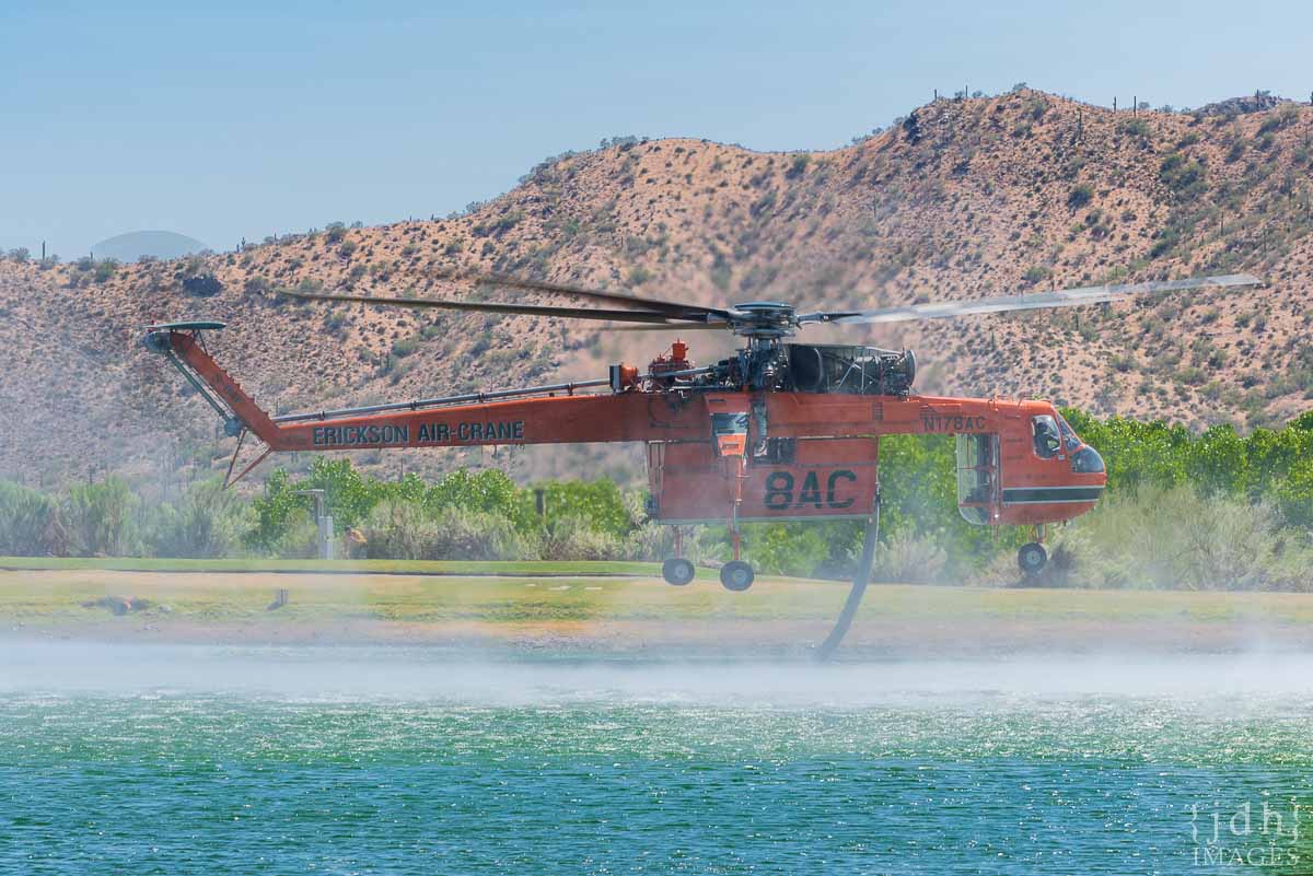
Skycrane “Isabelle” N178AC, a Sikorsky S-64F from Erickson Incorporated fills her 2,500 gallon tank at the Rancho Manana Golf Club while fighting the nearby Central Fire burning in the Tonto National Forest near New River, AZ on June 21, 2020. Photo by John Hall.
— Daisy Mtn Fire & Medical (@DaisyMtnFire) June 20, 2020
(Originally published at 12:47 p.m. MDT June 21, 2020)
Air Tanker 914, a DC-10, drops retardant on the Central Fire, June 20, 2020. Photo by JDH Images.
Eleven months ago firefighters battled a wildfire north of Phoenix about 35 miles north of Phoenix, 4 miles east of Interstate 17. There was confusion about the name of the fire, switching from Central to Daisy and back to Central.
Saturday the same thing happened in the same location. A fire started in the footprint of the 2019 Central Fire. The name changed from Central to Daisy and back to Central.
Red dots represent heat on the June 20, 2020 Central Fire detected by a satellite at 3:21 p.m. MDT June 20, 2020. Retardant from the July 20, 2019 Central Fire is visible in the background satellite photo taken August 12, 2019.
In the satellite photo above taken August 12, 2019, 23 days after the first Central Fire, you can make out retardant which was dropped by air tankers. Within those retardant lines are superimposed red dots representing heat on the June 20, 2020 Central Fire detected by a satellite at 3:21 p.m. MDT June 20, 2020.
The Southwest Coordination Center lists the current Central Fire at 2,000 acres. Since the Saturday afternoon overflight, satellites have not been able to detect any large heat sources on the fire, but it is likely burning, or was burning, in light fuels such as grass, and cooled quickly between overflights.
Last year we made the map below:
Map showing the location of the Central Fire 35 miles north of Phoenix at 3:21 p.m. MDT July 20, 2019.
The Incident Management Team on the Bush Fire northeast of Phoenix is managing the Central Fire.
The Bush Fire grew Saturday by 9,171 acres to bring the total up to 184,531 acres. Firefighters have had success in recent days stopping the spread at Highways 87 and 188. They are closely watching the south side as it backs slowly downhill through light vegetation to Apache Lake and the Salt River.
The Central and Bush Fires in the Phoenix Area, June 21, 2020.