McKinney Fire prompts evacuations northwest of Yreka, CA

Updated 5:58 p.m. PDT July 31, 2022

The AlertWildfire camera in Northern California on Herd Peak recorded the effect of what is likely outflow winds from a thunderstorm affecting smoke from the McKenney Fire. At the time on Sunday afternoon July 31, 2022 it had burned about 52,000 acres northwest of Yreka. It appears that the fire is spreading across the ground, but most likely it is just smoke.

To see all articles on Wildfire Today about the McKinney Fire, including the most recent, click HERE.

Rain on the fire
It was very spotty, but some locations on the McKinney Fire received rain Saturday night between 10 p.m. and 3 a.m. Sunday morning. The weather station on Mt. Baldy on the western edge of the fire received just over half an inch, Scott Barr three miles west of the fire got 0.19″, and Oak Knoll off Highway 96 received 0.01″. Several locations near Yreka recorded no precipitation.

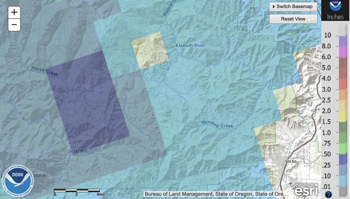
There are very few weather stations in or near the fire area, but the National Weather Service produced the map below with estimated precipitation amounts based on radar observations.
rain McKinney Fire
Radar observed precip, for the 24-hour period ending at 5 a.m. PDT July 31, 2022. NWS.

The west side of the fire received the most precipitation, according to the radar, with much less on the east side. The radar data is just an estimate, but it appears possible that a good sized portion of the west side received at least a wetting rain, with much of that side experiencing between 0.10 and 0.50″. If this is the case, the east side should see more fire growth for at least the next day or so than on the west side.

Fire activity
The rain combined with an inversion Saturday evening to slow the fire, but activity increased in some locations around midnight. Crews were actively engaged in structure protection in the Klamath River area. Little progression was observed on the southeast side closest to Yreka.

The McKinney Fire was mapped Sunday afternoon at 52,499 acres. The China 2 Fire 15 miles west of the McKinney Fire has burned 1,652 acres on the south side of Highway 96.

Sunday
Priorities for Sunday are to continue structure preparation and protection in the Highway 96 corridor, and around the communities of Fort Jones and Yreka.

Homes destroyed
The Siskiyou County Sheriff’s Office has confirmed that several structures have been destroyed. Sheriff’s office Spokeswoman Courtney Kreider said residences along Highway 96 in the Klamath River drainage burned. She did not have a specific number.


Updated at 5:36 a.m. PDT July 31, 2022
McKinney Fire map 3-D
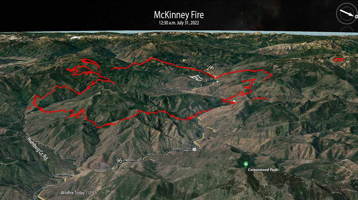
McKinney Fire 3-D map, looking west-southwest at 12:30 a.m. PDT July 31, 2022. The white lines were the perimeter at 5:19 p.m. on July 29.

The McKinney Fire in Northern California eight miles south of the Oregon state line was very active throughout the night. When it was mapped by an aircraft at 12:30 a.m. Sunday it had grown to 51,468 acres. During a satellite overflight at 3:38 a.m. about 90 percent of the heat detected was on the east and southeast sides.

This was the only complete mapping of the fire since noon on Saturday due to thunderstorms and lightning in the area which restricted flights of air tankers and helicopters.
McKinney Fire map
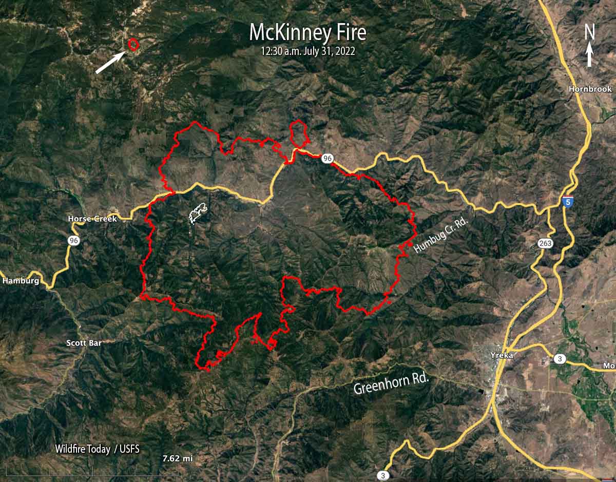
McKinney Fire map at 12:30 a.m. PDT July 31, 2022. The white line was the perimeter at 5:19 p.m. on July 29.

At 12:30 a.m. Sunday it was 5 miles northwest of Yreka, 2 miles north of Greenhorn Road, 5 miles west of Highway 263, 4 miles east of Scott Bar, and 2 miles east of Horse Creek.

The mapping flight found a 75-acre fire burning four miles northwest of the McKinney Fire east of Condrey Mountain. It is unknown at this point if it a new fire or a spot from the McKinney.

Another fire 15 miles west of the McKinney Fire, the China 2 Fire, has burned approximately 1,000 acres south of Highway 96 in the Seiad Valley area.

Weather
Isolated and scattered thunderstorms with little or no rain are predicted for the area on Sunday with gusty outflow winds of 40-50 mph and cloud to ground lightning. Pyrocumulus could regenerate with potential for rapid fire growth and spread. There is a 5 percent chance of wetting rain. The relative humidity will be 15 to 25 percent.


Updated 6:41 p.m. PDT July 30, 2022

Saturday afternoon the area around the McKenny Fire northwest of Yreka, California was covered by cumulonimbus clouds, thunderstorms with lightning. This made it very difficult for air tankers, helicopters, or mapping aircraft to work over the blaze. Even the AlertWildfire cameras on mountain peaks late in the afternoon could see nothing but smoke. But satellite imagery peeking through breaks in the clouds detected intense heat from the fires.

The video below shows lightning and heat detected by a satellite during a 2-hour period ending at 6:21 p.m. PDT July 30 in Northern California and southwest Oregon. The red areas represent heat from the fires. The white line is the Oregon/California border. The white flashes are lightning.

Evacuations are in effect over a large area, ordered by the Siskiyou County Sheriff. Details can be found on their Facebook page.Zonehaven Aware map is also available.

At 3 p.m. Saturday the US Forest Service estimated the fire had burned 30,000 to 40,000 acres.


Updated 1:20 p.m. PDT July 30, 2022
McKinney Fire map, 12:04 p.m July 30, 2022

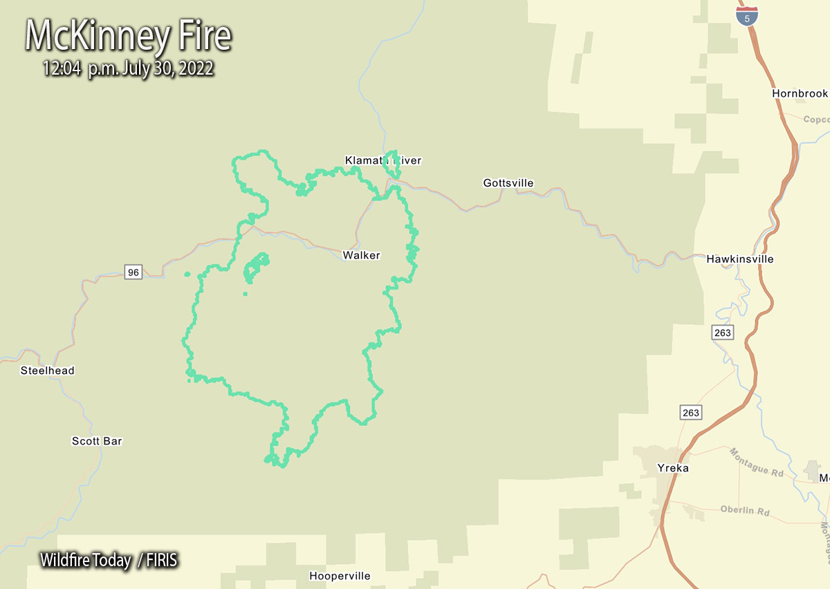
The FIRIS aircraft mapped the McKinney Fire at an astounding 29,493 acres just after noon today. That explosive growth is less than 24 hours after it was reported at 2:15 p.m. Friday. (See map above)

This current map shows us that at 12:04 p.m. Saturday it was 9 miles west-northwest of Yreka, 3 miles northwest of Scott Bar, and 3 miles west of Gottsville.

During its first 22 hours it spread north 4 miles, east 5 miles, south 6 miles, and west about 2 miles.


9:48 a.m. PDT July 30, 2022
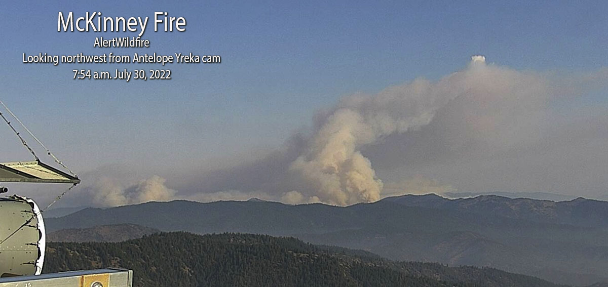
McKinney Fire

The McKinney Fire northwest of Yreka, California grew rapidly after it was reported Friday afternoon south of Highway 96 in the Klamath National Forest. Since then it has spread north across the highway and also to the south.  At about 5 a.m. Saturday the Siskiyou County Sheriff said it was approximately four miles from Scott Bar after having been very active all night.

At about 8:45 a.m. on Saturday the Klamath National Forest estimated it had burned approximately 18,000 acres. The most recent perimeter map available is from Friday at 5:19 p.m., when it was only 65 acres. This current estimate from the Forest Service indicates it is 277 times larger. Additional perimeter mapping data was most likely prevented by lightning and thunderstorms in the area.

The fire was 14 miles northwest of Yreka when first reported, but grew closer overnight.

Evacuations are in effect over a large area, ordered by the Siskiyou County Sheriff. Details can be found on their Facebook page.Zonehaven Aware map is also available.

Continue reading “McKinney Fire prompts evacuations northwest of Yreka, CA”

Most of the work still remaining on the Oak Fire is on northeast side

Posted on Categories WildfireTags ,

The fire is east of Mariposa, California

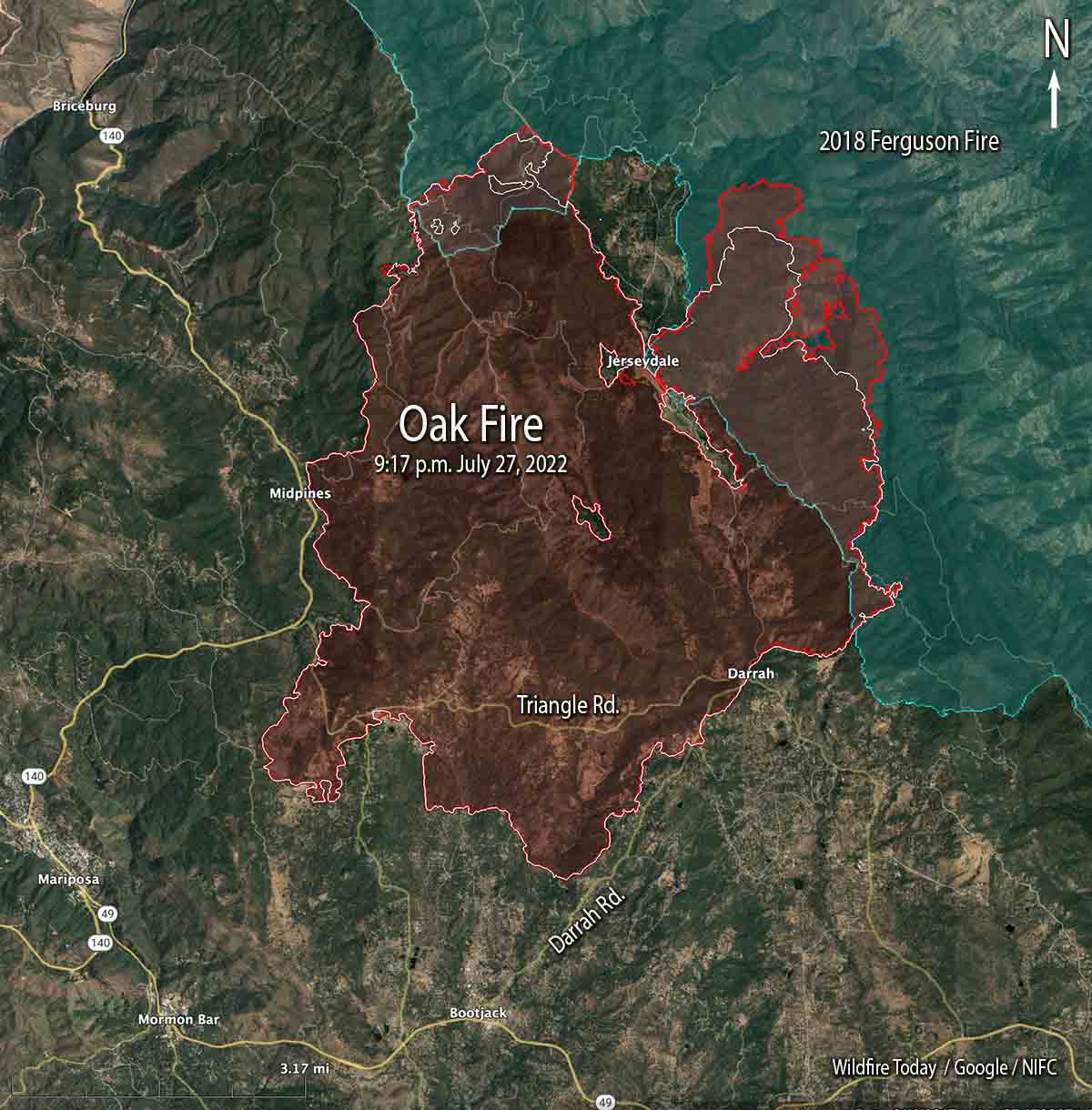
Oak Fire map 9:17 p.m. July 27, 2022
Oak Fire map. The red line was the perimeter at 9:17 p.m. July 27, 2022. The white line was the perimeter about 48 hours before.

Most of the perimeter of the Oak Fire northeast of Mariposa, California was quiet on Wednesday, with the exception of the north and northeast sides where it has continued to spread. Firefighters have constructed firelines in those areas, some of them indirect, and are making progress. It has moved one to two miles into the footprint of the 2018 Ferguson Fire.

To see all articles on Wildfire Today about the Oak Fire, including the most recent, click HERE.

The fire was mapped Wednesday night at 19,169 acres.

The video below was shot by the FIRIS aircraft looking south at the northeast side of the fire at 9:20 p.m. July 27. White indicates heat.

Scientists hope data collected at prescribed fire will help develop better technologies to detect and monitor fires

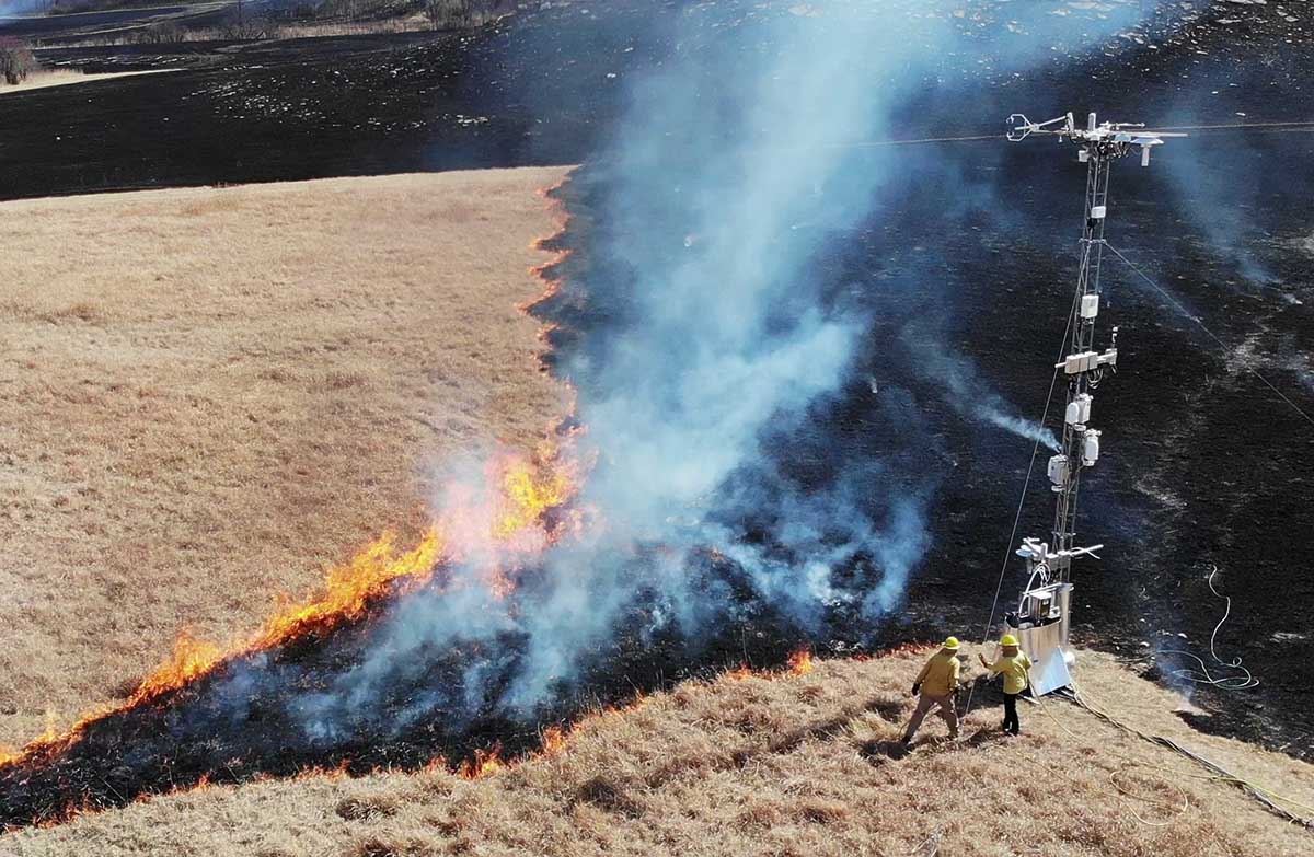
Sage multichannel sensing during prescribed fire
Argonne scientists monitor a controlled burn on the Konza prairie in Kansas using the Sage monitoring system. (Image by Rajesh Sankaran/Argonne National Laboratory.)

Scientists recently deployed a complex array of sensors during a prescribed fire at the Konza tallgrass prairie in Kansas to collect a vast trove of data. It was immediately processed at the site using advanced computing technologies provided by a new platform called Sage.

Sage offers a one-of-a-kind combination that involves multiple types of sensors with computing ​at the edge”, as well as embedded machine learning algorithms that enable scientists to process the enormous amounts of data generated in the field without having to transfer it all back to the laboratory. Computing ​at the edge” means that data is processed where it is collected, in the field, while machine learning algorithms are computer programs that train themselves how to recognize patterns.

Sage is funded by the National Science Foundation and developed by the Northwestern-Argonne Institute for Science and Engineering (NAISE), a partnership between Northwestern University and the U.S. Department of Energy’s Argonne National Laboratory.

Equipment used to monitor a controlled burn on the Konza prairie in Kansas using the Sage monitoring system. (Image by Rajesh Sankaran/Argonne National Laboratory.)

The advanced cyberinfrastructure deployed in Sage, which allows for on-the-spot detection, monitoring, and analysis of the burned area, could offer scientists and natural resources officials the ability to get ahead of forest fires with quickly analyzed, multi-instrumented data.

When it comes to forest fires, time is absolutely of the essence,” said Argonne computational scientist and NAISE Fellow Rajesh (Raj) Sankaran. ​Often, there’s no time to move data from the field — where high-speed connectivity might be an issue — to the lab. With Sage, we’re getting the pertinent information we need when we need it.”

The prescribed fire in the Konza prairie gave the researchers a large collection of data — almost 60 DVDs worth — full of information about the progression of smoke and fire. This data can be used to educate a machine learning algorithm that can make further determinations of the behavior of other fires in real time.

After the success of the Sage network in Kansas, future plans exist for the network to be deployed in California, Colorado, Illinois, and Texas as part of a network led by the National Ecological Observatory Network (NEON). Eventually, researchers hope to establish a continent-spanning network of smart sensors that could employ Sage technology. ​

NEON is developing a mobile deployment platform that can complement land-based and aquatic sites all over the country,” Sankaran said. ​Sage can play a supportive role in many different environments throughout the United States.”

CNN covers legislation that would increase pay for federal wildland firefighters

Updated at 9:20 a.m. EDT July 31, 2022

The House of Representatives narrowly passed the legislation Friday. Now it goes to the Senate.


12:46 EDT, July 27, 2022

Wildfire Response and Drought Resiliency Act
Rep. Joe Neguse interviewed on CNN July 27, 2022 about the Wildfire Response and Drought Resiliency Act.

In this video from CNN, Brianna Keilar interviews Colorado Rep. Joe Neguse about the Wildfire Response and Drought Resiliency Act, H.R. 5118, which would benefit wildland firefighters. It boosts their pay and benefits, helps the Forest Service fill gaps in fire management staff, and promotes bigger forest management projects to reduce hazardous fuels.

The bill is a conglomeration of half a dozen pieces of legislation,  including the Tim Hart Wildland Firefighter Pay Parity Act (H.R. 5631), all rolled into one. It would require that the minimum basic pay for any Federal wildland firefighter position be no less than the pay for a GS-6 Step 3, which is $42,946 a year ($21.29 an hour).  It would also stipulate that the salary be adjusted annually by not less than the change in the Consumer Price Index.

Suspected arsonist captured and tied to tree by locals

Updated at 12:06 p.m. PDT July 27, 2022

mapJ uly 25 arson fires in Southwest Oregon
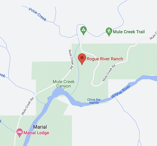
General area of the July 25 arson fires in Southwest Oregon.

On Monday a Bureau of Land Management employee reported that a man was walking down a road igniting vegetation fires in a remote area about 25 miles northwest of Grants Pass, Oregon.

From the AP:

Ground crews, assisted by local residents, and three helicopters quickly got the two fires under control, Curry County Sheriff John Ward said.

Meanwhile, three local residents located the suspect walking on the road near the fires and detained him.

“It was reported that the suspect became very combative with the three residents and had to be tied to a tree to subdue him.,” Ward said in a statement. “An ambulance crew was asked to respond due to some injuries that the suspect apparently received from falling down.”

Smith was transported to Three Rivers Hospital in Grants Pass and once he was medically cleared, transported by US Forest Service law enforcement to the Curry County Jail and held on Reckless Burning and two counts of First-Degree Arson. There was also a Detention Warrant in effect out of Lane County for probation violation.

Trennon Ray Smith mug shot
Trennon Ray Smith. Lane County Sheriff’s Office.

Forest Service withdraws decision about 50,566-acre fuel treatment project in New Mexico

Planned on the Santa Fe National Forest

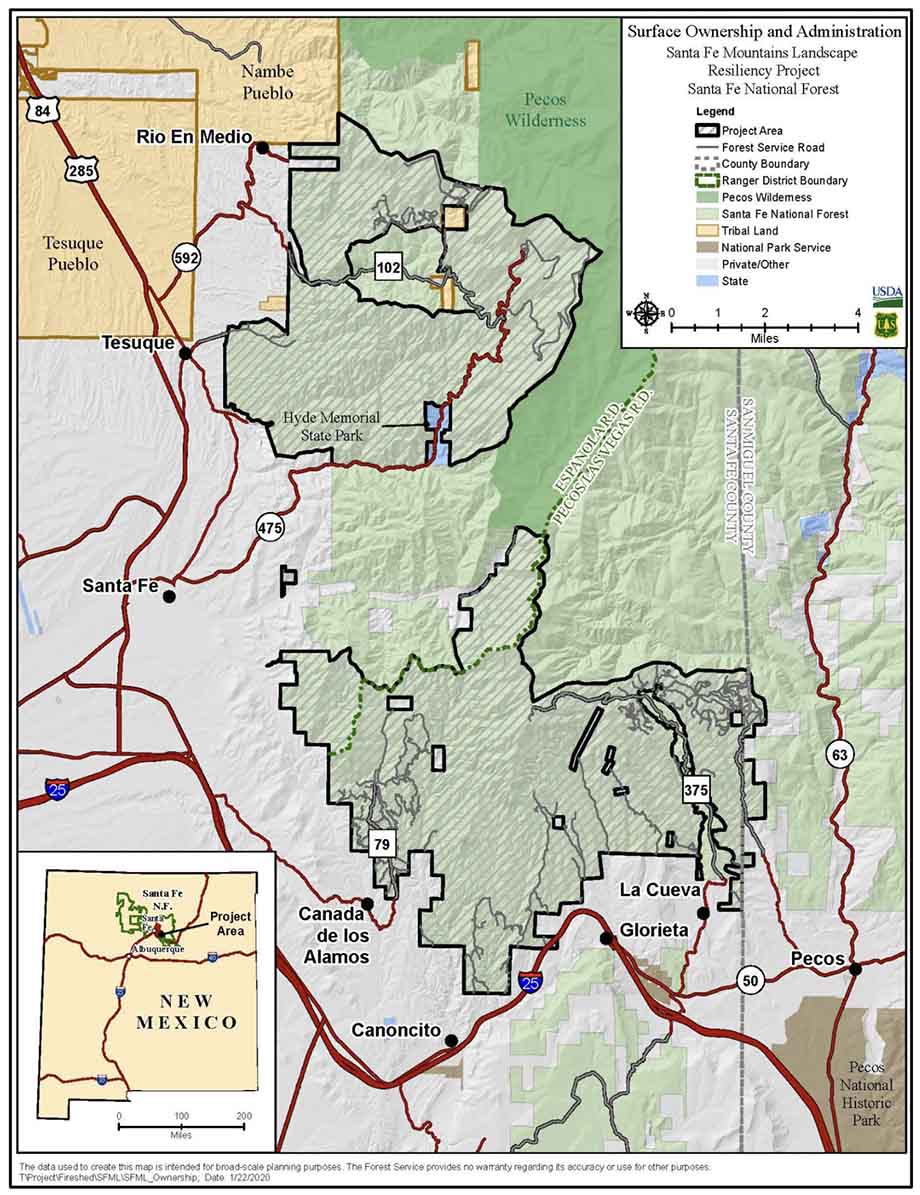
The U.S. Forest Service announced Tuesday that they are withdrawing the draft Decision Notice and Finding of No Significant Impact issued in March for the 50,566-acre Santa Fe Mountains Landscape Resiliency Project. It would involve prescribed fire and vegetation thinning treatments on 36,680 acres east of Santa Fe, New Mexico on a landscape scale. Each year at least 750 acres would have been thinned and up to 4,000 acres would have been treated with prescribed fire during a 15- to 20-year time frame.

Map Santa Fe Mountains Landscape Resiliency Project
Map of the Santa Fe Mountains Landscape Resiliency Project.

On July 12 the Board of County Commissioners of Santa Fe County passed a resolution urging the FS to conduct a full Environmental Impact Statement (EIS) for a planned very large fuel management project. The FS went through the much less complicated Environmental Assessment (EA) process, which included the draft EA, public outreach, and accepting comments, then issued a Finding of No Significant Impact (FONSI) which they felt enabled the implementation of the project.

The statement issued by the Santa Fe National Forest dated July 26, 2022 said, “The SFNF is taking this step to reengage with our partners and community on this very important project to improve forest health in and around Santa Fe…Our intent is to reinitiate the decision and NEPA process for this project after the Chiefs 90-day pause with the publication of a legal notice in the Albuquerque Journal, the newspaper of record. If you previously submitted an objection to the final environmental assessment and draft notice of decision, you will need to resubmit your objection at that time.”

After three prescribed burning projects on the Santa Fe National Forest got out of control since 2018 and had to be converted to wildfires, some of the locals are worried about future projects on the forest.

The current 341,735-acre Calf Canyon / Hermits Peak Fire is the result of two prescribed fires that escaped control earlier this year on the Santa Fe National Forest. One was a broadcast burn that crossed control lines during strong winds. The other originated from slash piles that were ignited in late January that continued burning for months. In mid-April one or more of those piles became very active during strong winds and merged with the other escaped fire on April 22. The fire has destroyed at least 400 homes, forced up to 18,000 people to evacuate their properties, resulted in flooding, and cost more than $248 million in firefighting expenses.

In 2018 another pile burning project on the Santa Fe escaped months after it was ignited and had to be converted to a wildfire. A Facilitated Learning Analysis found that “communication” and “prescribed fire preparation and risk” were common themes.

The notice from the FS is below.

[pdf-embedder url=”https://wildfiretoday.com/wp-content/uploads/2022/07/USFS_withdraws_Decision_Notice.pdf” title=”USFS withdraws Decision Notice Santa Fe National Forest”]


The USFS documents regarding the project can be found here.