Fatalities in Camp Fire near Paradise, Calif. increase to 23

More than 6,000 homes destroyed

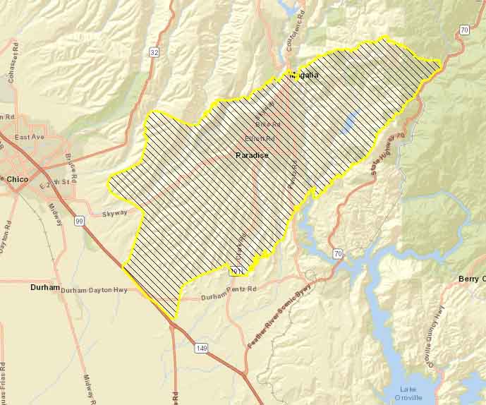
map Camp Fire Paradise California wildfire
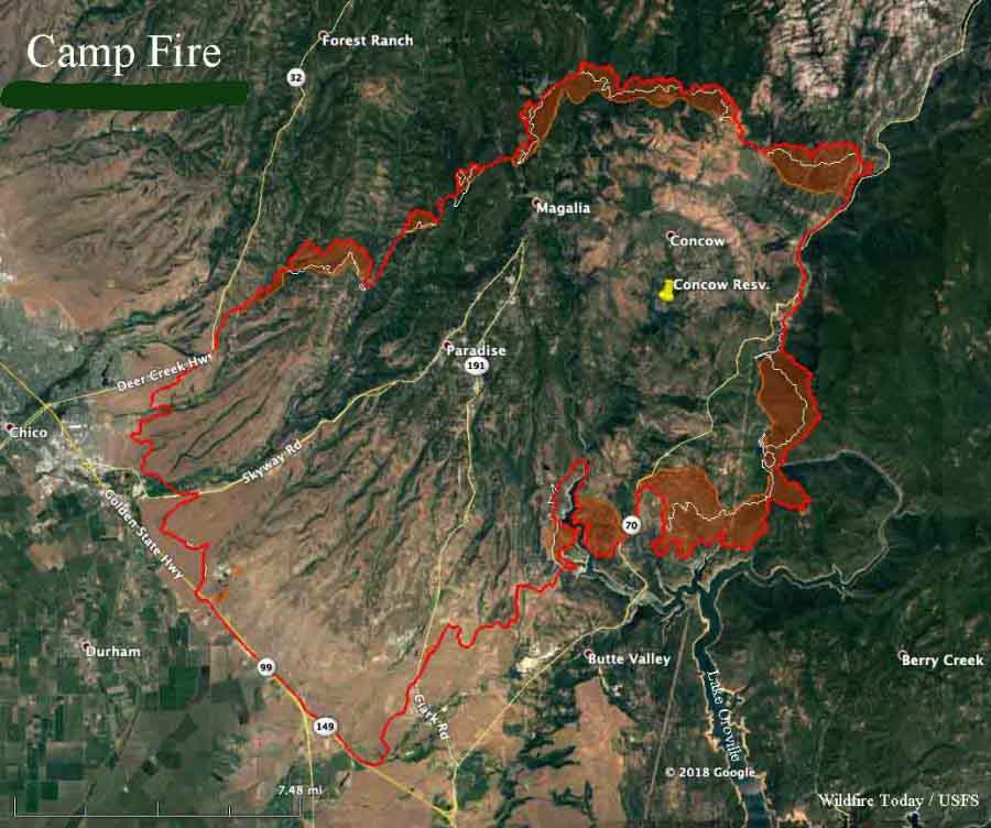
Map of the Camp Fire. The red line was the perimeter at 9 p.m. PST November 10, 2018. The white line was the perimeter about 24 hours before. Intense heat is indicated by the red shaded areas. Click to enlarge.

(UPDATED at 1:15 p.m. PST November 11, 2018)

The Camp Fire at Paradise, California continued to be very active Saturday and Saturday night. The areas spreading the most were the north and east sides. Around Big Bend north of Lake Oroville, the fire moved 0.5 to 1.0 mile. CAL FIRE reports that the fire has covered 109,000 acres.

(To see all articles on Wildfire Today about the Camp Fire, including the most recent, click here.)

After gusting at 10 to 22 mph overnight, the winds on the Camp Fire slowed considerably after sunrise Sunday, and came out of variable directions at about 2 mph.

Forecasters expect the wind to increase Sunday night out of the northeast at 17 mph, gusting to 24. The humidity will be in the lower teens late Sunday afternoon, increasing to 21 percent during the night. The fire activity could increase Sunday night.  The wind speeds should decline to about 5 mph Monday afternoon.

The number of people that died in the Camp Fire in northern California has risen by 14, the Butte County Sheriff’s Office confirmed Saturday night. With the nine found earlier, this brings the total to 23. The victims have been found near residences and in the burned ruins of vehicles and homes in Paradise and Concow. It is possible that these numbers will increase in the coming days.

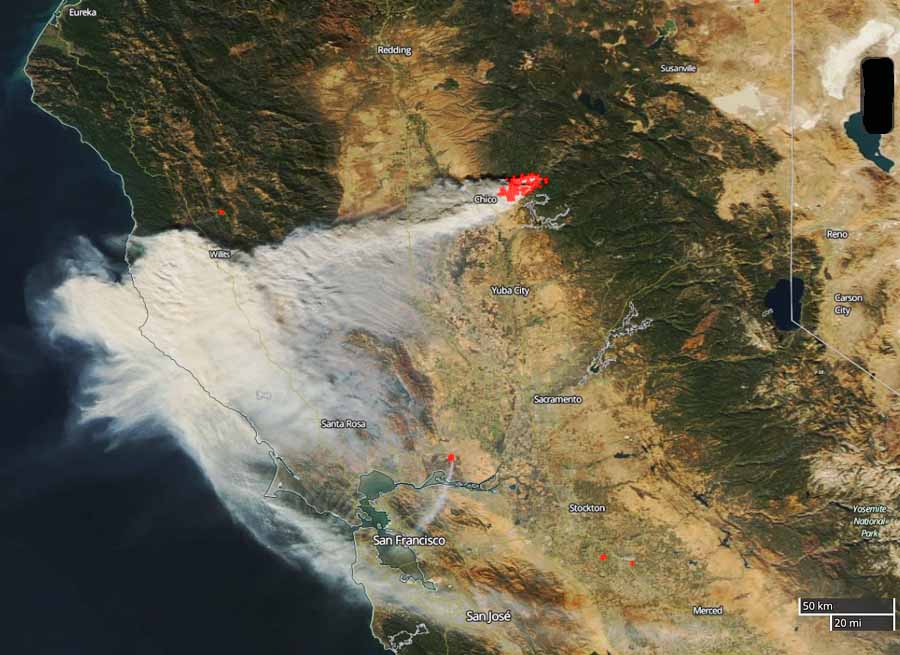
The fire is still producing a prodigious amount of smoke which is moving off to the south and southwest.
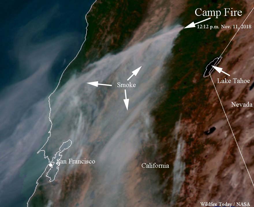
Satellite photo smoke Camp Fire Paradise California
Satellite photo of smoke produced by the Camp Fire at 12:12 p.m. PST, November 11, 2018.

Below is a Sunday morning update from CAL FIRE:

“Last night the fire conditions were moderate to extreme due to the wind event. Crews continued to protect structures and fight fire aggressively. Fire lines are strategically being put in ahead of the fire to improve roads and provide barriers to the fire. Today [Sunday] the fire and firefighters will continue to be impacted by the strong winds. With the northeast wind pushing smoke to the southwest air operations will take advantage of the clearer air on the eastern side of the fire as long as weather and smoke conditions permit. Firefighters and cooperating agencies are continuing to mitigate many hazards within Paradise, CA.

“At 0700 hrs [Sunday] morning the Camp Fire Incident entered unified command with USFS.”


(UPDATED at 9 p.m. PST November 10, 2018)
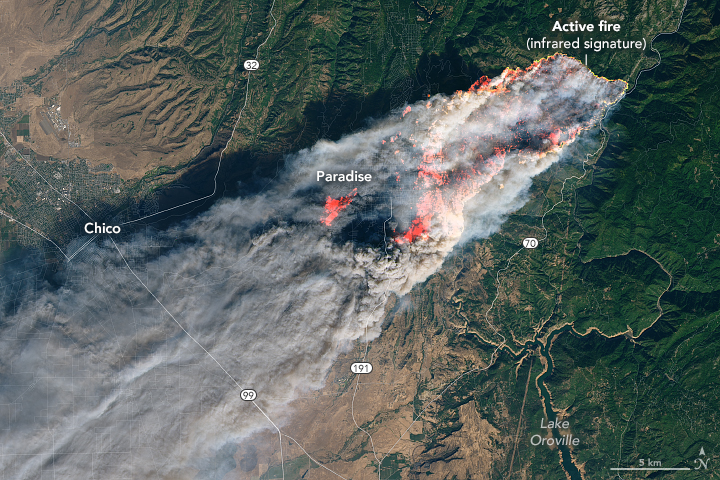
satellite photo Camp Fire Paradise California
Camp Fire as seen from NASA’s Operational Land Imager on Landsat 8 at 10:45 a.m. PST November 8, 2018. The photo was taken about 4 hours and 15 minutes after the fire started. Click to enlarge.

The number of people that died in the Camp Fire in northern California has risen by 14, the Butte County Sheriff’s Office confirmed Saturday night. With the nine found earlier, this brings the total to 23. The victims have been found near residences and in the burned ruins of vehicles and homes.

None of them have been positively identified due to the condition of the remains. The California Department of Justice will help set up a process whereby relatives can give DNA samples to assist with identifications.

At least 110 are still missing.

CAL FIRE reports that the Camp Fire has burned 105,000 acres.


(Originally published at 8:22 a.m. PST November 10, 2018)

The news from the Camp Fire that burned through Paradise, California keeps getting worse. Authorities reported that four additional fatalities are confirmed, bringing the total to nine. Some of the nine were found in burned vehicles, others were on the ground near structures, and one was discovered in a residence.

(To see all articles about the Camp Fire on Wildfire Today, including the most recent, click here.)

Officials reported that 6,453 homes and 260 other structures have been destroyed, making the Camp Fire the most destructive in California history.

The number of fatalities and burned structures could increase in the coming days as firefighters are able to access more areas.
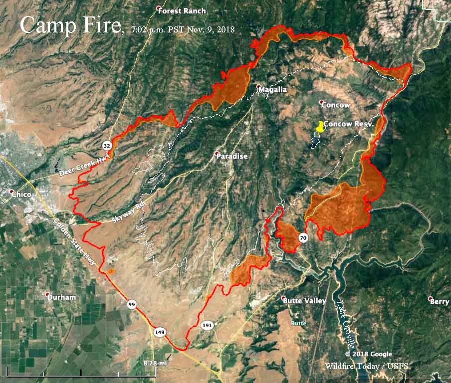
Map of the Camp Fire
Map of the Camp Fire. The red line was current at 7:02 p.m. PST November 9, 2018. The white line was the perimeter 25 hours before. The red shaded areas represent intense heat. Click to enlarge.

The mayor of the town of Paradise estimates that 80 to 90 percent of the structures were wiped out.

On Friday the north half of the fire was actively spreading, including the northernmost edge, areas west of Magalia, near the northwestern arm of Lake Oroville, and the fire edge east and south of Concow Reservoir.

CAL FIRE is saying the Camp Fire has burned 100,000 acres.

Pacific Gas & Electric disclosed to the Public Utilities Commission that one of their high voltage power lines had a disruption in service on Pulga Road near the Camp Fire at 6:15 a.m. the day it started. The fire was reported at 6:29 a.m.

Resources assigned to the fire include 440 engines, 18 water tenders, 23 helicopters, 67 hand crews, and 67 dozers for a total of 3,223 personnel.

Description of the video below: “Leaving Paradise, California towards Chico down Pentz Rd the morning of Friday, November 9th. This is the area around Lime Estates.”

Woolsey Fire burns to the ocean as 200,000 evacuate

Scores of homes have been destroyed

map Woolsey Fire
Map of the Woolsey Fire at 9:50 p.m. PST November 10, 2018. Click to enlarge.

(Originally published at 6:28 a.m. PST November 10, 2018)

The Woolsey Fire advanced to the Pacific Ocean Friday, spreading 15 miles south from Simi Valley to Malibu. A 15-mile long section of the coastal communities were invaded by flames, which then crossed the Pacific Coast Highway (PCH) along a five-mile stretch near the Mulholland Highway and Decker Road. An unknown number of multimillion dollar mansions and more modest homes succumbed to the fire as about 200,000 residents evacuated from 75,000 homes in Malibu, Calabasas, Agoura Hills, Oak Park, Thousand Oaks, and other areas. The Los Angeles County Fire Department PIO said at 6:52 p.m. Friday, “…very significant number of homes in the operational area damaged or destroyed by fire”, and that it had burned approximately 35,000 acres.

(To see all articles about the Woolsey Fire on Wildfire Today, including the most recent, click here.)

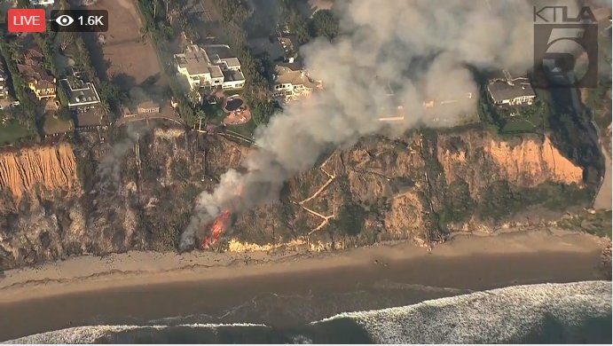
Woolsey fire on Malibu beach
Fire at the beach threatens structures above. KTLA.

A mapping flight Friday night at 9:50 determined that the fire had burned 89,906 acres, but it was still spreading.

There have been no confirmed reports of fatalities.

There were reports that the fire was very close to Pepperdine University in Malibu near the PCH and Las Virgenes Road, but the University tweeted at 3:34 a.m. that they were OK.

@FirePhotoGirl broadcast live video from the general area of Pepperdine at around 1:30 a.m. Saturday.


Below are maps, zoomed in, of where the Woolsey Fire reached the coastal areas, and of the northern section of the fire.

Continue reading “Woolsey Fire burns to the ocean as 200,000 evacuate”

Wildfires near Thousand Oaks, California put over 100,000 homes under evacuation orders

The Hill and Woosley Fires started Thursday evening.

(UPDATED at 4:48 p.m. PST November 9, 2018)

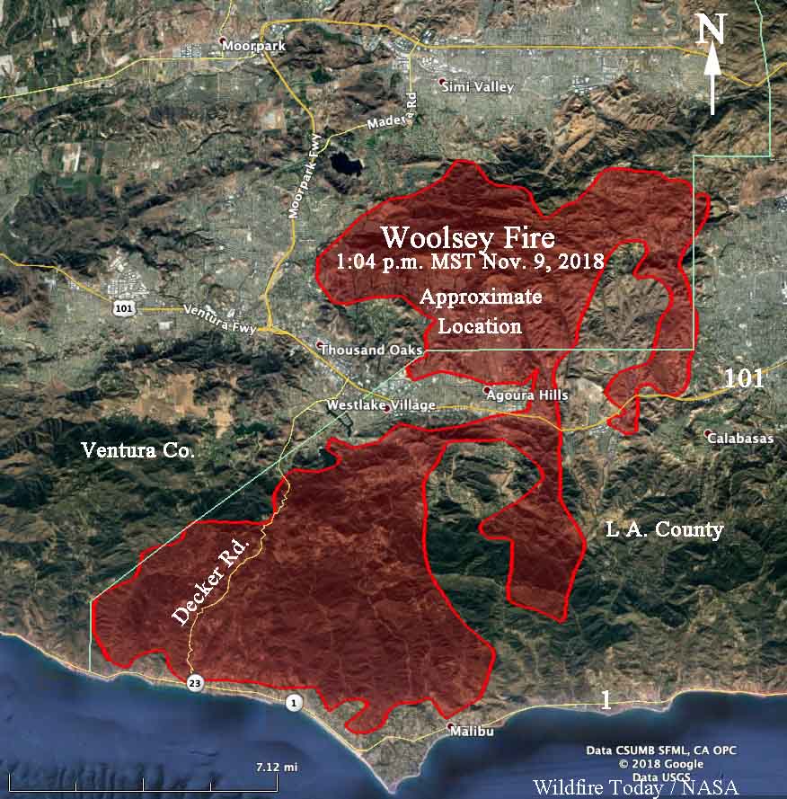
map Woolsey Fire
Map showing the APPROXIMATE, ESTIMATED perimeter of the Woolsey Fire at 1:04 p.m. November 9, 2018. Click to enlarge.

Disclaimer: Above is a very, very rough map showing the APPROXIMATE location of the Woolsey Fire that has burned from Simi Valley south to Malibu in Southern California. It is based on heat sensing data from a satellite flying hundreds of miles above the earth which is not always 100 percent accurate. It is possible that the fire burned through some areas of light vegetation, such as grass, then self-extinguished and cooled before the next overflight which occurs about every 12 hours. Some areas that are shown as unburned may not have been detected by the heat sensors and could actually have been burned.

(To see all articles about the Woolsey Fire on Wildfire Today, including the most recent, click here.)

We only produced this estimated perimeter map because as far as we know no government agency has released a one of the Woolsey Fire. If and when they do, it will no doubt be more accurate than this version.

At 1 p.m. Friday, L. A. County reported the fire had burned 14,000 acres. Our very, very rough estimate is approximately 50,000 acres.


(UPDATED at 1:40 p.m. PST November 9, 2018)

The Incident Commander on the Woolsey Fire estimates it has burned about 14,000 acres. The fire started at 2:30 p.m. Thursday east of Simi Valley and was blown by strong Santa Ana winds south across the 101 Freeway Friday morning. It is now approaching the Pacific Ocean, and all of Malibu is under an evacuation order. About 150,000 residents have evacuated. Traffic on the Pacific Coast Highway is extremely congested as people attempt to leave the area.

There is a report that dogs, horses, and pigs have been seen on the beach, taking refuge from the fire.

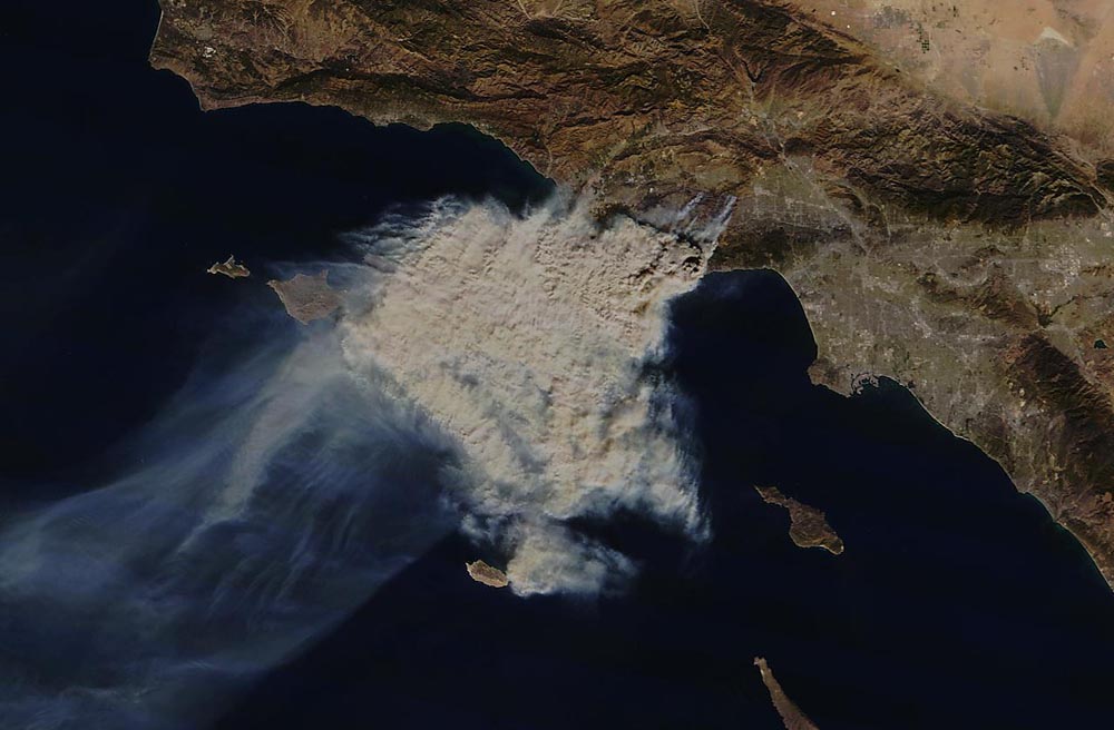
Woolsey Fire
Satellite photo showing smoke from the Woolsey Fire at Malibu, California. MOODIS.
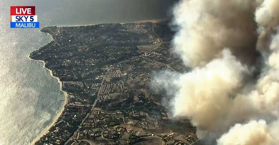
Whoolsey Fire
The Woolsey Fire approaches the Pacific coast. KTLA
747 air tanker drop
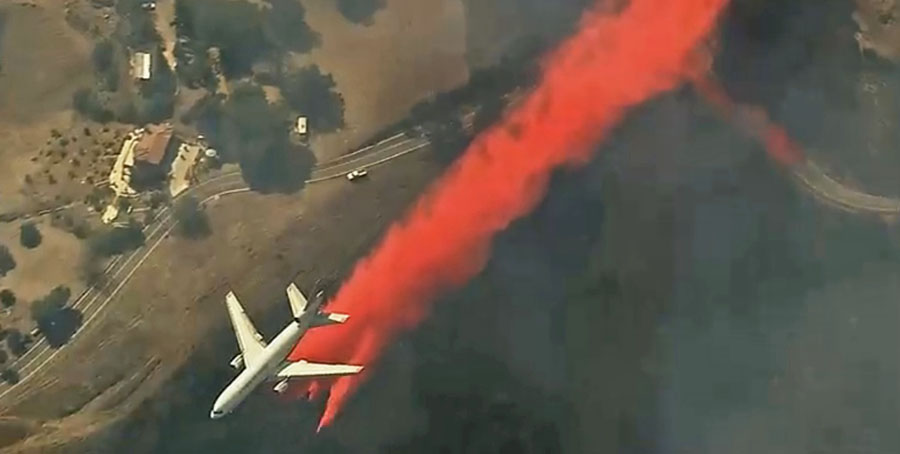
A DC-10 air tanker drops on the Woolsey Fire Nov. 9, 2018. KTLA.


(Originally published at 11:12 a.m. PST November 9, 2018)

Two large wildfires that started November 8 near Thousand Oaks, California have prompted officials to place 75,000 homes under mandatory or voluntary evacuation orders.

The Woolsey Fire burned over 9,000 acres near Thousand Oaks and Agoura Hills north of the 101 Freeway Thursday, but Friday morning it jumped across the highway near Liberty Canyon Road in Agoura. At about 9 a.m. local time the Los Angeles County Fire Department PIO said it was “headed to the ocean”.

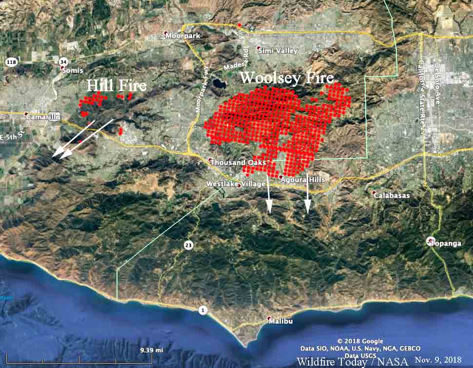
map Hill Fire Woolsey Fire
Map showing heat detected by a satellite over the Hill and Woolsey Fires at 1:48 a.m. PST November 9, 2018. The arrows indicate the direction the fires spread after the satellite overflight. Click to enlarge.

The Hill Fire also jumped the 101 near Camarillo Springs Road and reached the freeway 12 to 15 minutes after it started, pushed by extreme winds. After crossing the freeway it moved into the scar from the 2013 Springs Fire and slowed considerably due to the lighter fuels. It  has burned about 6,100 acres as of Friday morning.

Mandatory evacuations were ordered for the Woolsey Fire south of the 101 Freeway to the coast — from the Ventura/LA County line east to Malibu Canyon Road, including areas in Malibu.

A resident of Malibu, @TracyWrights, tweeted Friday morning:

The power is out in #Malibu. We had NO IDEA any evacuation order was in place until we got in the car and heard the news on @KNX1070. Our community does NOT KNOW to get out and PCH is now gridlocked for miles. #Woolseyfire

The Ventura County FD PIO said at about 1 a.m. Friday that multiple structures were burning near Erbes Road and Moorpark Road in Thousand Oaks.

Both fires started in Ventura County but the Woolsey Fire crossed into Los Angeles County near the 101.

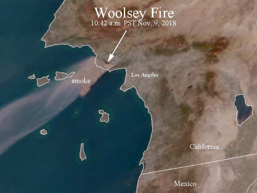
Satellite photo smoke Woolsey Fire
Satellite photo showing smoke from the Woolsey Fire at 10:42 a.m. PST November 9, 2018. Click to enlarge.

Maps that show the distribution of wildfire smoke in California can be found here.

The Saddlerock weather station between Thousand oaks and Malibu recorded overnight winds out of the northeast of 12 to 15 mph gusting to 25, but they increased after sunrise with sustained winds of 18 gusting to 33 mph. The forecast calls for the wind speeds to decrease Friday afternoon.

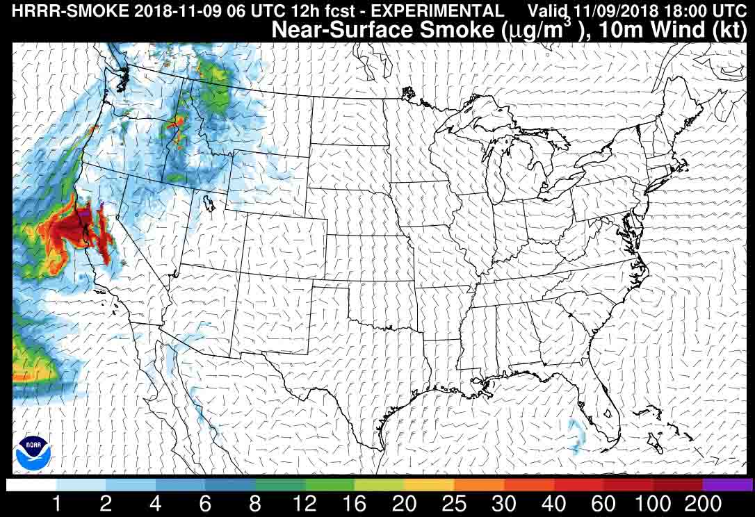
Wildfire smoke mapsmok

wildfire smoke map

The map above shows the prediction for the distribution of wildfire smoke at noon PST November 9. Click on the map to see a larger version.

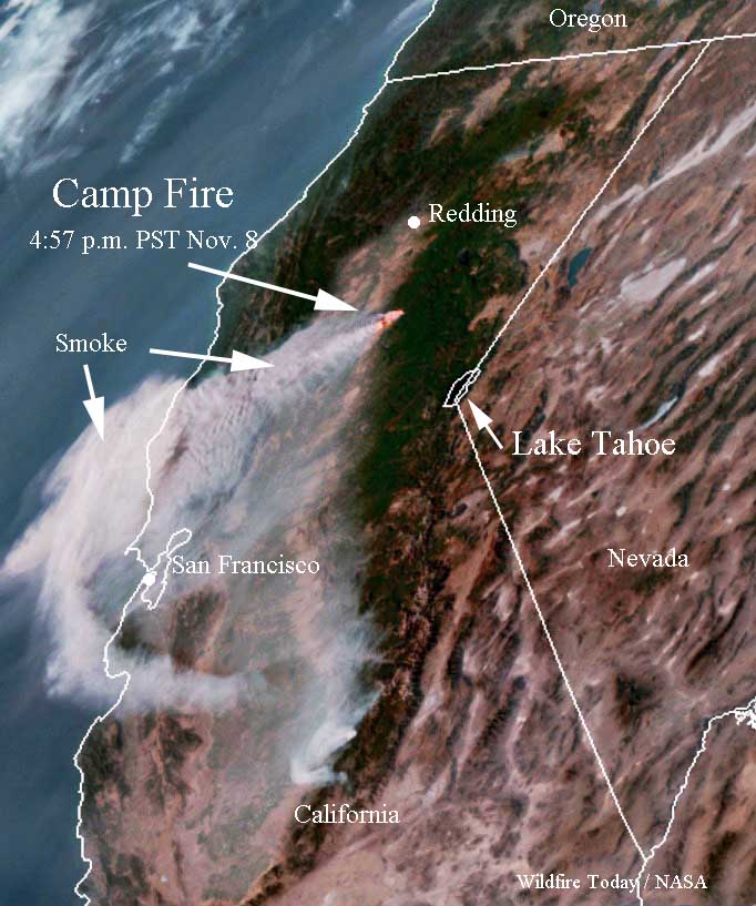
Below is a satellite photo taken Thursday, November 8 showing heat from the Camp Fire in red and the smoke being blown to the southwest, mostly north of San Francisco.

smoke Camp Fire California

Satellite photo smoke Woolsey Fire
Satellite photo showing smoke from the Woolsey Fire at 10:42 a.m. PST November 9, 2018. Click to enlarge.

Camp Fire burns hundreds of homes in Northern California

Severe damage in Paradise, California

(UPDATED at 11:20 a.m. PST November 9, 2018)

The CBS station in Sacramento had this information Friday morning:

The Butte County Sheriff’s Office says at least five people have been found dead after the Camp Fire tore through the town of Paradise on Thursday. Investigators found the five people in the area of Edgewood Lane in Paradise inside of cars. It’s believed the victims were overcome by the Camp Fire when they were in their cars. No identification of the victims was able to be made due to the burn injuries, deputies say.

Investigators have been working to confirm reports of fatalities due to the destructive fire. Anyone with missing loved ones are encouraged to check http://safeandwell.org.


(Originally published at 7:45 a.m. PST Nov. 9, 2018)

In the first 12 hours the Camp Fire burned 54,000 acres as it roared through Paradise, California destroying large sections of the city.

(To see all articles about the Camp Fire on Wildfire Today, including the most recent, click here.)

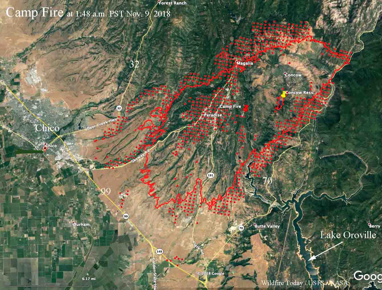
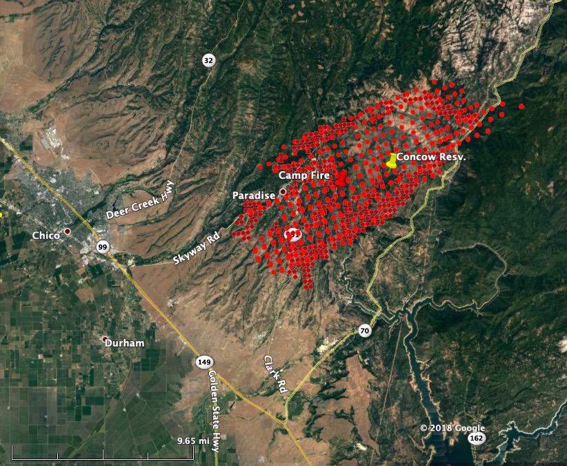
The wildfire started at 6:33 a.m. November 8. A mapping flight at 6 p.m. determined it had spread 15 miles to the southwest pushed by winds that at times in the higher elevations gusted to 65 mph out of the northeast. At 6 p.m. it had come to within two miles of Highway 99, but at 1:48 a.m. Friday a heat-sensing satellite found that it had neared the highway in at least two places and was approaching the outskirts of Chico.

map Camp Fire
The red line was the perimeter of the Camp Fire at 6 p.m. November 8. The red dots represent heat detected by a satellite at 1:48 a.m. Nov. 9. Click to enlarge.

Fire officials are saying that hundreds of homes have burned but it could be days before accurate numbers are available.

Overnight the fire spread closer to Highway 70 on the east side, and on the west side it approached Highway 32 and moved through Magalia where heavy structure losses can be expected.

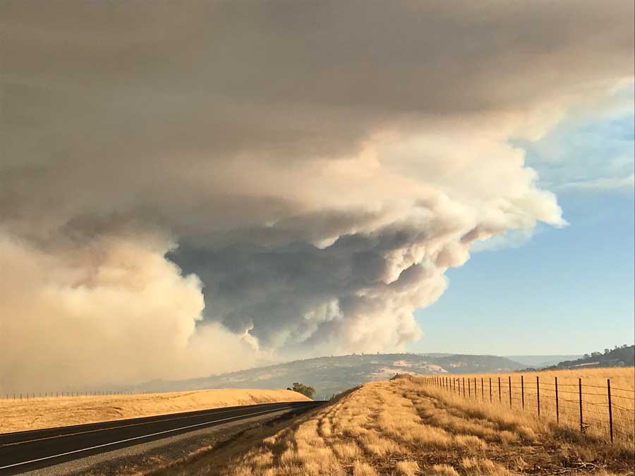
After sunrise Friday the fire was very active, as seen in the photo below.

camp fire smoke column
The Camp Fire, early Friday morning November 9, 2018. SJSU FireWeatherLab.

The Feather River Hospital was evacuated, but there are conflicting reports on the status of the facility. Some say it burned, others say one or more structures at the site burned but the main building is intact.

The mapping flight at 6 p.m. Thursday determined that the fire had burned over 54,000 acres, but the satellite data from 8 hours later showed that it had increased substantially since then, possibly as much as an additional 15,000 acres. CBS in Sacramento reported at 7:02 a.m. that a spokesperson for CAL FIRE said the fire had grown to about 70,000 acres.

Heavy concentrations of smoke are affecting areas southeast of the fire. To see a map for the prediction of the distribution of smoke and a satellite photo showing the smoke, click here.

On the southeast side of the fire the Jarbo Gap weather station recorded overnight wind speeds of 28 mph gusting to 44 with 18 percent relative humidity. Those conditions should continue through the morning in the higher elevations on the fire but the winds will decrease substantially in the afternoon.

Update at 10:49 a.m. PST November 9, 2018. We found the following map on InciWeb, but there does not appear to be any further information on the site about the Camp Fire.

Camp Fire map
Camp Fire map. Inciweb.

Wildfire burns into Paradise, California, forcing evacuations

Hundreds of structures have burned

(UPDATED at 7:03 p.m. PST November 8, 2018)

Camp Fire map
The red squares on the map represent the approximate location of heat detected by a satellite over the Camp Fire at 1:30 p.m. PST Nov. 8, 2018. Click to enlarge.

From an article in the Chico ER, updated at 6:36 p.m. Thursday:

Cal Fire-Butte County Chief Darren Read said in the afternoon that hundreds of structures in Paradise have burned, perhaps as many as 1,000. Butte County Sheriff Kory Honea said there are reports of multiple fatalities, and authorities are trying to verify how many.

The Sheriff’s Department estimates that 50,000 people have evacuated.

(To see all articles about the Camp Fire on Wildfire Today, including the most recent, click here.)

At 3:15 Thursday CAL FIRE estimated that the fire had burned 18,000 acres. Our very, very rough approximation of the size that is indicated by the heat detection in the map above from 1:30 p.m. puts it at around 28,000 acres. Those heat detections can sometimes be inflated when a very intensely burning fire carries a high concentration of burning embers into the smoke column downwind of the fire.

Satellite photo Camp Fire
Satellite photo of the Camp Fire at 4:57 p.m. November 8, 2018. Click to enlarge.

On Thursday afternoon the wind was out of the northeast at 17 mph gusting to 30, with 11 percent relative humidity. Friday night the wind should be similar, northeast at 16 gusting to 34, with 23 percent RH. The weather on Friday should be much more in favor of the firefighters — 68 degrees, RH 13 percent, and much lighter northeast winds at about 8 mph, decreasing to 2 mph by sunset.

The state of California has activated their State Operations Center.

California State Operations Center
California State Operations Center. OES photo.


(UPDATED at 1:50 p.m. November 8, 2018)

Camp Fire map
The red squares on the map represent the approximate location of heat detected by a satellite over the Camp Fire at 12:46 p.m. PST Nov. 8, 2018. Click to enlarge.

Air Attack has requested seven air tankers for the Camp Fire: four S-2s, two large, and one very large air tanker (DC-10). Apparently the wind speeds have decreased, making it possible to use the fixed wing air tankers.

At 12:13 p.m. a weather station southeast of Paradise recorded sustained winds at 13 mph with gusts up to 33 mph with a relative humidity of 13 percent.

At 1:13 p.m. Friday KRCR published a video interview with “John”, a CAL FIRE PIO, who said the estimated size of the Camp Fire was 17,000 acres. Our very, very rough approximation of the size that is indicated by the heat detection in the map above puts it at around 25,000 acres. Those heat detections can sometimes be inflated when a very intensely burning fire carries a high concentration of burning embers into the smoke column downwind of the fire.


Camp Fire map
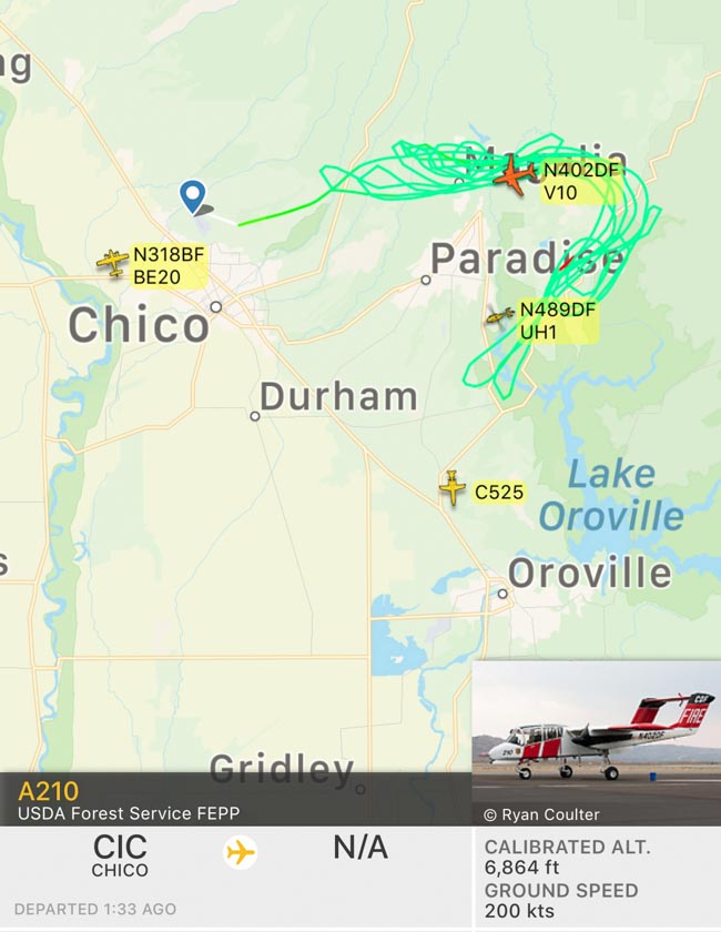
The green line represents the flight path of Air Attack 210, a Bronco, as it flies around the Camp Fire near Concow and Paradise, California at 9:25 a.m. PST November 8, 2018.

(UPDATED at 12:14 p.m., November 8, 2018)

The winds have been too strong on the Camp Fire at Paradise, California for air tankers and water-dropping helicopters to assist firefighters on the ground. The wind speed increased dramatically at about sunset on Wednesday with gusts out of the northeast up to 50 mph. The wind has slowed on Thursday with sustained speeds at 6 to 18 mph and gusts at 22 to 30 mph.

Continue reading “Wildfire burns into Paradise, California, forcing evacuations”