A firefighter analyzes how the Carr Fire burned into Redding, California

When Royal Burnett retired he was Chief of the Shingletown Battalion of the Shasta-Trinity Ranger Unit in Northern California

Above: Screen shot from the video of the fire tornado filmed by the Helicopter Coordinator on the Carr Fire July 26, 2018 near Redding, California. 

When Chief Royal Burnett retired in 1993 his employer’s agency was still called California Department of Forestry (CDF). At that time he was Chief of the Shingletown Battalion of the Shasta-Trinity Ranger Unit in Northern California. Still keeping his hand in the game, Chief Burnett recently spent some time analyzing how the disastrous Carr Fire spread into his town, Redding, California in July of 2018.

“I retained my interest in fire and fuel modeling after retirement”, the Chief said, “and with my fire geek friends I try to keep current.”

Chief Burnett told us that when he left the CDF he was qualified as a Type 2 Incident Commander, Type 1 Operations Section Chief, Type 1 Planning Section Chief, and Fire Behavior Analyst. He has lived Redding, California for 40 years.

The article below that the Chief wrote about his analysis of the Carr Fire is used here with his permission. A version of it has previously appeared at anewscafe.


The Carr Fire burned 229,651 acres and 1,079 residences, about 800 in the county area and the remaining number inside the city limits.

My friends Steve Iverson, Terry Stinson and I spent several days looking at the portion of the Carr Fire burn where it entered the city of Redding. This would be the Urban portion of the Wildland Urban Interface. That part of our town is newer construction, high-end subdivision homes built to California’s “SRA Fire Safe Regulations”. That is, non-flammable roofs, stucco siding, and all the rest of the State’s requirements. How did we lose almost 300 of them in one wildfire?

Royal Burnett
Royal Burnett

Many of these homes were built right on the edge of the Sacramento River canyon on finger ridges to maximize the view, or on the rim of side draws — anything to maximize the view from the property and capture the afternoon up-canyon wind flow. Most had large concrete patios and some had pools. There were no wooden decks extending over the canyon that I saw.

The Canyon is about ½ mile across where most of the houses burned, with the slope estimated at around 100 percent. The aspect where most of the homes burned is west-facing, meaning it catches the afternoon sun and preheats the forest fuels.

The canyon itself was predominantly filled with manzanita 12 to 15 feet high (75 percent) and the remainder was oak woodland, with scattered ceanothus brush and poison oak . The brush field was approximately 75 years old, having sprouted after Shasta Dam was completed in 1945. Available fuel loading ranged from 1 to 3 tons per acre in the oak woodland to 13 tons per acre in the heavy brush. All herbaceous material was cured and live fuel moisture was approximately 80 percent in manzanita — right at the critical level, which means it will burn as if its a dead fuel, not a live one.
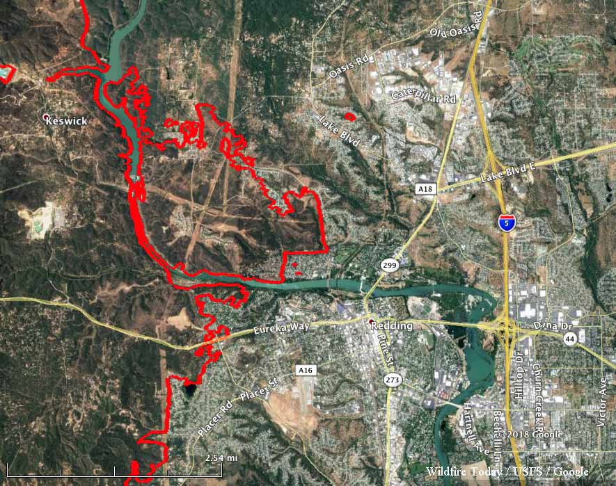
map Carr Fire Redding
The east side of the Carr Fire near Redding, California. Mapped August 26, 2017. Click to enlarge.

So, we’ve got a canyon filled with tons and tons of very flammable brush on an extremely steep slope with hundreds of very pricey homes perched on the rim, on a day when the temperature was 112 degrees and relative humidity was around 9 percent. To repeat a phrase from the 1960s, this was a “Design For Disaster”. (That was the title of fire training film describing the events of the Bel Air fire in Los Angeles County in 1961). [below]

We can determine how things burned by looking at burn patterns and other forensic evidence. For those who did this for a living its like reading a book. It was easy to figure out why the houses on the rim burned — they were looking right down the barrel of a blowtorch. Even though they had fire resistant construction, many had loaded their patios with flammable lawn furniture, tiki bars and flammable ornamental plants. Palm trees became flaming pillars, shredded bark became the fuse, junipers became napalm bombs.

Under current standards houses are build 6 to an acre; 10 feet to the property line and only 20 feet between houses. Once one house ignited, radiant heat could easily torch the next one.

We followed burned wood fence trails from lot to lot — wooden fences were nothing more than upright piles of kindling wood — and then into some ornamental shrubbery with an understory of shredded bark which torched and set the next house on fire. Then the fire progressed away from the canyon rim, not a wildland fire now, but a series of house fires, each contributing to the ignition of the next one.

We noted several, perhaps as many as a half dozen homes that burned from the ground up. Fire entered the building at the point where the stucco outer wall joined the slab and fire in the decorative bark was forced into the foam insulation and composition board sheeting under the stucco by the wind. Normally a fire in decorative bark is not a problem, it simply smolders. But in this case, where literally every burning ember was starting a spot fire and those spot fires were fanned by 100 mph in-draft wind, those smoldering fires were fanned into open flames which burned the homes. A simple piece of flashing could have prevented some of that loss.

We built homes to a fire resistant standard and then compromised them.

The fire hit Redding on an approximately two-mile front. It spotted across the Sacramento River in several locations and spread rapidly in the canyon, spawning numerous fire whirls. The updrafts caused the convection column to rotate, generating firestorm winds estimated at 140 mph. I’d guess most of the homes that were lost burned in the first hour after the fire crossed the river. The fire and rescue services were overwhelmed.

Sacramento River Redding
View from the Sacramento River in Redding north of the Sacramento River Trail Bridge. Google Street View. Click to enlarge.

The city of Redding allowed home construction on canyon rims, places that have proven to be fire traps over the years in almost every community where this construction has been allowed. Houses built in those exposed areas are similar to houses built in a flood zone. Its not a question IF they will burn, the question is When?

These subdivisions had limited egress. In one high-priced gated subdivision there is only one way in or out. Redding planners have seemingly ignored the lessons from past disasters like the Tunnel Fire in Oakland Hills in 1991 where 2,900 homes burned and 25 people died.

The city’s green belts have proven to be nothing but time bombs — fuel choked canyons that are a haven for her homeless. How many fire starts have we had in the canyon below Mercy Hospital, or in Sulfur Creek below Raley’s on Lake Boulevard? The homeless problem has exacerbated the fire problem. The fuels are there, the homeless provide the starts.

Even today, new subdivisions are being built overlooking the burned out canyons, looking across the rim at the ruins of homes burned in the Carr Fire.

The Sacramento River canyon will regrow, and it will be more flammable next time and stumps sprouting brush and noxious weeds will germinate in the burned area. The skeletons of the burned trees will become available fuel. In a couple of years the fuel bed will be more receptive to fire than it was before the Carr Fire.

If we don’t learn from our mistakes we are doomed to repeat them.

Thanks and a tip of the hat go out to Kelly.
Typos or errors, report them HERE.

Power outage hits Hong Kong trains, sky lantern seen as culprit

Sky lantern
Sky lantern release in Chiang Mai, Thailand. Photo by Takeaway.

A sky lantern is suspected of causing a power outage on a railroad in Hong Kong, causing four trains to be disrupted for 25 minutes until repairs were made.

Below is an excerpt from an article at ejinsight.com:


Passengers aboard the trains were forced to wait in the cars before services gradually resumed about 25 minutes later after repairs were carried out.

MTR personnel investigating the incident found the remains of a sky lantern on top of one of the trains, although the railway operator did not confirm whether it had triggered the power failure, the Hong Kong Economic Journal reported.

Earlier that day, the Leisure and Cultural Services Department (LCSD) reminded the public that it is an offense to fly sky lanterns.

Under the law, people who fly sky lanterns could face a maximum fine of HK$2,000 and up to 14 days of imprisonment.

These dangerous devices use burning material to loft a small paper or plastic hot air balloon into the air. The perpetrator has no control over where it lands. Usually the fire goes out before it hits the ground, but not always. Sometimes the envelope catches fire while in flight. Numerous fires have been started by sky lanterns. Even if they don’t ignite a fire, they leave litter on the ground. Metal parts have been picked up by hay balers causing serious problems when fed to livestock. They are banned in most U.S. states and many countries.

Roosevelt Fire destroys at least 22 homes

The fire has burned over 50,000 acres 6 miles south of Bondurant, Wyoming

Above: A helicopter drops retardant near Rim Station on the Roosevelt Fire September 25, 2018. Inciweb photo.

After a survey Tuesday by the Sublette County Sheriff’s Office of 50 of the 153 homes in the Hoback Ranches subdivision, 22 were found to have been destroyed by the Roosevelt Fire. Property owners are being notified by the Sheriff’s Office. The fire is 6 miles south of Bondurant, Wyoming.

Wednesday while firefighters were conducting a burnout operation on the east side of the fire, Highway 189/191 was fully closed between Stinking Springs and Daniel Junction. The powerline along the highway has been shut down during the burnout, which affects the Kendall Valley and Upper Green areas.

Map Roosevelt Fire wyoming
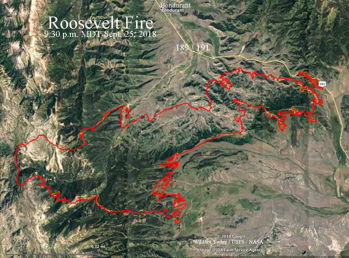
Map of the Roosevelt Fire. The red line was the perimeter at 9:30 p.m. MDT on September 25. The white line was the perimeter about 24 hours before. Click to enlarge.

On Tuesday the burnout near the highway was 2.2 miles long between Forest Road 30681 and Forest Lane.

Most of the significant growth on the fire Tuesday was on the east side within one to three miles of Highway 189/191. The rest of the fire exhibited low activity with no additional spread to the south, southeast, or west. In the area of Rolling Thunder, firefighters conducted burnout operations to further secure the fire edge. The fire did not move towards Jim Bridger Estates.

There was low fire intensity in the Upper Hoback and Kilgore Creek areas and firefighters continued to tie the open fire line into natural features to prevent fire movement east and west. In Hoback Ranches, firefighters knocked down hotspots to further secure homes in the area.

Resources assigned to the fire include 26 hand crews, 10 helicopters, 56 fire engines, 6 dozers, and 12 water tenders for a total of 982 personnel.

A Red Flag Warning is in effect in the area Wednesday for strong winds and dry fuels.

University chemist and students take flight with groundbreaking wildfire emission study

A flying laboratory carrying researchers from the University of Montana has the capacity to change what we know about future fires

Above: University of Montana and Colorado State University students in the Aircraft Observations and Atmospheric Chemistry course pose in front of their flying laboratory equipped with state-of-the-art instruments to map the smoke over the western US this past summer. Photo credit: Ali Akherati.

MISSOULA – Most aircraft slicing through the smoke above wildfires either drop water or smokejumpers in an effort to manage fire on the ground. But one plane – a flying laboratory carrying researchers from the University of Montana – has the capacity to change what we know about future fires.

This summer, the four-engine cargo plane spent more than 100 hours slicing through smoke above fires burning in the West, collecting data about the chemical composition of smoke and how it changes over time and travel.

The National Science Foundation National Center for Atmospheric Research C-130 research aircraft was based in Boise, Idaho this summer, but it sampled wildfire plumes in California, Oregon, Washington, Idaho, Nevada and Montana. The results will provide a new understanding of air quality and how it may affect populations downwind.

Assistant Professor Lu Hu from UM’s Department of Chemistry and Biochemistry, along with four UM graduate students, are part of the research team funded to work on the study through a multimillion-dollar collaborative NSF project called the Western Wildfire Experiment for Cloud Chemistry, Aerosol Absorption and Nitrogen, or WE-CAN. It is the “largest, most comprehensive attempt to date to measure and analyze wildfire smoke,” according to the NSF.

Hu and his atmospheric chemistry group are leading the investigation into chemistry and emission of organic pollutants from smoke. The team deployed UM’s new mass spectrometer on the C-130 research aircraft.

This instrument provided real-time measurements of volatile organic compounds in wildfire smoke and more insight into organic gas composition than previously possible. The emissions from wildfires are typically toxic, and they can form ground-level ozone and fine particulate matter, which are linked to serious health impacts and regulated by the U.S. Environmental Protection Agency.

“We expect to observe many toxic species from smoke that had been rarely characterized or reported before,” Hu said. “This unprecedented and rich dataset will help us better predict air quality downwind and understand how fire smoke impacts the climate system.”

Back in the lab on campus, Hu and his team focus to interpret how cloud chemistry, aerosol absorption and reactive nitrogen in wildfire plumes affect air quality, nutrient cycles, weather, climate and the health of those exposed to smoke.

The collaborative study includes researchers from Colorado State University, the University of Colorado-Boulder, the University of Wyoming, the University of Washington and the National Center for Atmospheric Research.

As part of this project, Hu teaches students aircraft observations in UM’s new Atmospheric Chemistry course. This educational initiative is co-led by Professor Emily Fischer of Colorado State University and Professor Shane Murphy of University of Wyoming. There are more than 30 students across three universities in the course, including seven students from UM.

The class brings the C-130 flying laboratory into a classroom. Students learn about the aircraft-based mission design and flight planning, and they just planned and executed three flights with the C-130 aircraft in early September. Last week, UM students traveled to Broomfield, Colorado, and visited other state-of-the-science laboratories of NCAR along with their educational flight.

Students will present what they learned from their educational flight later in the semester.

“Bringing cutting-edge research into a classroom is very fun and a great experience for both students and instructors,” Hu said. “Opportunities for aircraft observations being taught and experienced in a classroom are almost zero due to reasons like the limited accessibility and perceived high expense. I am just extremely happy that our UM students are involved in this rare and valuable educational opportunity.”

###

The course is sponsored by the UM College of Humanities & Sciences Toelle-Bekken Family Memorial Fund Award and the Department of Chemistry and Biochemistry.

For more information on the project, call Hu at 406-243-4231, email lu.hu@mso.umt.edu or visit http://hs.umt. edu/luhu.

Roosevelt Fire approaches Highway 189/191

(UPDATED at 8:29 a.m. MDT September 25, 2018)

With the Roosevelt Fire approaching to within a quarter-mile of Highway 189/191 firefighters are again planning to conduct a burning operation on the southwest side of the road on Tuesday. They had hoped to start it Monday, but decided to postpone it.

The fire started September 15 and is 6 miles south of Bondurant, Wyoming.

Weather conditions Tuesday should be much more favorable than on Monday. After below freezing temperatures overnight, the forecast calls for 59 degrees, relative humidity in the teens, and west winds of 5 to 9 mph.

map Roosevelt Fire
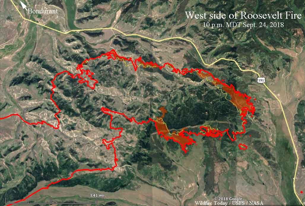
Map of the east side of the Roosevelt Fire. The red line was the perimeter at 10 p.m. MDT on September 24. The red shaded areas indicate intense heat. The white line was the perimeter about 24 hours before. Click to enlarge.

The fire grew by approximately 1,500 acres Monday to bring the total up to 49,805 acres. This was a smaller increase than in recent days, with most of the growth occurring on the east side where the perimeter roughly parallels Highway 189/191.


(Originally published at 6:27 p.m. MDT September 24, 2018)

Firefighters on the Roosevelt Fire 30 miles south of Jackson, Wyoming are attempting to fight fire with fire. Their goal Monday through Wednesday of this week is to use a backfire on the southwest side of Highway 189/191 to burn off the vegetation ahead of the fire, hoping it will serve as a barrier as the main fire spreads into the already burned vegetation.

On Monday it was a very difficult task, with 10 to 12 mph winds out of the west and northwest gusting at 20 to 26 mph. These conditions could increase the chance of spot fires across the highway from burning embers lofted by the strong winds.

map Roosevelt Fire
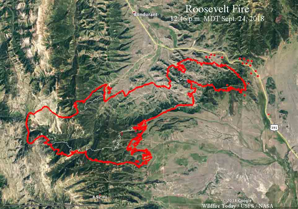
Map of the Roosevelt Fire. The red line was the perimeter at 9:20 p.m. MDT on September 23. The white line was the perimeter on Sept. 19. The red dots near Hwy. 189/191 represent heat detected by a satellite at 12:46 p.m. MDT September 24, 2018.

A Red Flag Warning is in effect for the area until 8 p.m. Monday. For Tuesday through Thursday the wind will decrease significantly. The temperatures will range from the teens at night to the 60’s during the day with little chance of precipitation. Those conditions should give firefighters a chance to make progress against the fire.

The fire is five miles south of Bondurant.

A mapping flight Sunday night at 9:20 determined that the fire had burned 48,348 acres.