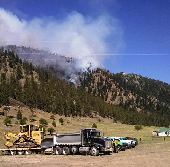
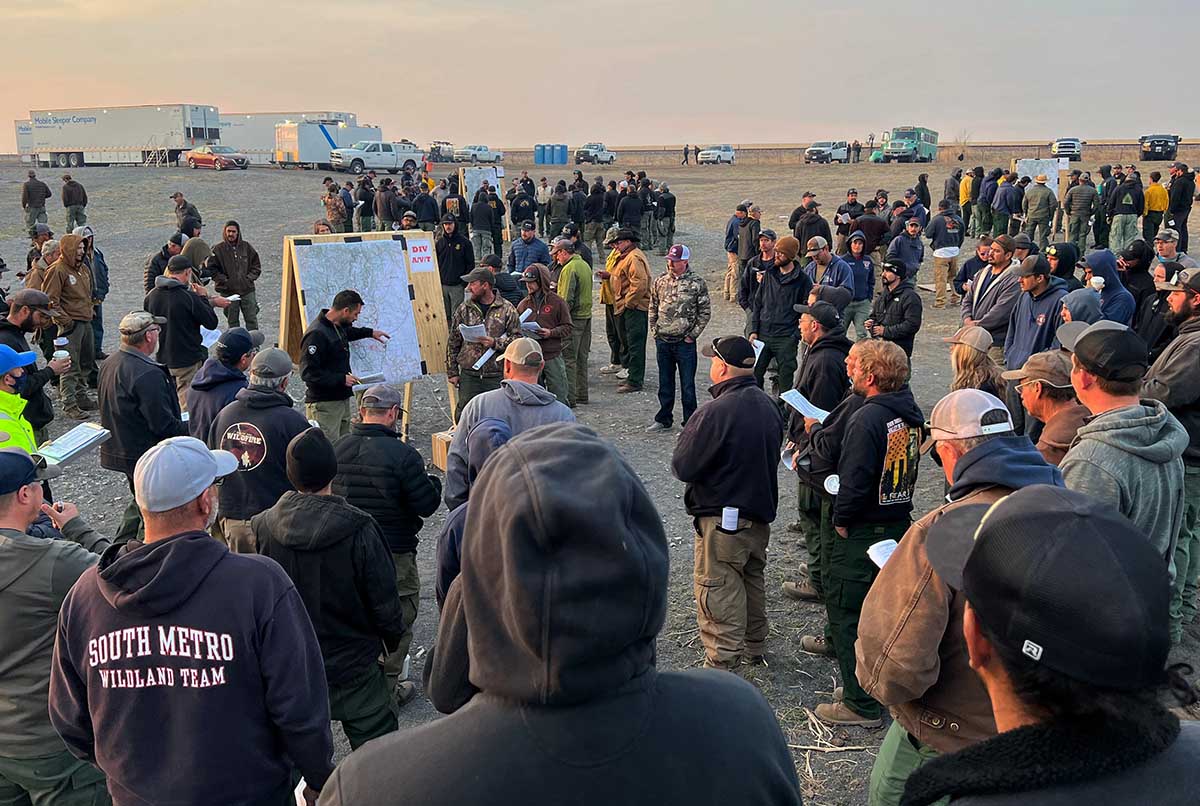
Staging area at the West Mullan Fire, July 15, 2013, 50 air miles northwest of Missoula, MT. InciWeb photo.
This weekend we are continuing an occasional weekend feature we started a few weeks ago. This post can serve as the beginning of an open thread where our readers can talk about issues that we have, or have not, gotten into yet. This is literally an off-topic thread.
The usual rules about commenting apply. And remember, no personal attacks or politics, please.
Let’s enjoy a wide-ranging debate!
(Oh, and send us pics of staging areas — date, location, and photographer’s name would be nice.)
At about 1 p.m. MDT on Saturday Planning Operations Section Chief Trainee Kevin Wilson said none of the 20+ telescopes at the Kitt Peak observatory were affected when the Contreras Fire ran up the steep brush-covered slopes to the site at 2 a.m. Friday. Two primary and two secondary structures burned, however. A separate report from the incident management team indicated that those four were “non-scientific buildings.”
Two Hotshot Crews (Helena and San Juan), five engines, Division Supervisors, and Safety Officers remained at the observatories as the fire approached very early Friday morning.
To see all of the articles on Wildfire Today about the Contreras Fire, including the most recent, click HERE.
Those firefighters “…had a solid 12 to 14 hour firefight,” Mr. Wilson said. “They were cut off when the fire impinged [Highway 386]. They had a very good safety area to work in. They had to disengage for a brief period of time from the fire and then re engaged when it was appropriate and were successful in saving the telescopes and the majority of the complex. This is a real heroic effort by these folks.”
Congratulations to these firefighters for overcoming what must have been an extremely challenging assignment considering the fuels and steep slopes surrounding the telescopes and other structures.
On the north end of the fire along Highway 86 near the Pan Tak and Cowtown communities, Saturday’s fire behavior is being monitored closely with the addition of extra crews and engines. There will be opportunities for direct attack by crews and air support due to moderate terrain and sparse vegetation.
The weather at the Sasabe weather station 11 miles southeast of the fire recorded moderate conditions early Saturday afternoon — 38 to 45 percent relative humidity, 90 degrees, and 13 mph winds out of the south-southwest under partly cloudy skies.
Updated at 12:19 p.m. MDT June 18, 2022
The staff from the Kitt Peak observatory provided this brief update at about noon on Saturday:
We’re hopeful that the worst may have passed for Kitt Peak National Observatory, but fire officials warn that the mountain is at risk for another week. The fire perimeter moved north of the peak, damaging the access road with passage very difficult. NOIRLab staff, escorted by the fire team, hope to be able to visit the summit today to begin damage assessment; we will provide an update later today.
Updated at 9:45 a.m. MDT June 18, 2022
Contreras Fire, June 17, 2022. Inciweb.
The scheduled mapping flight for the Contreras Fire Friday night had to be cancelled due to weather, most likely clouds that obscured the view from the aircraft. A flight Friday afternoon determined it had burned 17,646 acres. At 2 a.m. MDT Saturday a satellite detected through a hole in the clouds heat west of the Kitt Peak observatories and west of Highway 386.
The fire reached the general area of the observatories at 2 a.m. Friday, but no information has been released about any possible damage to the telescopes or dozens of structures.
The Sasabe weather station 11 miles southeast of the fire recorded 0.03 inch of rain Friday that occurred around 9 a.m. and 7 p.m. The relative humidity rose to 71 percent Friday night. The forecast for Saturday is mostly cloudy with a 30 percent chance of showers and thunderstorms through the day, with a high of about 86 degrees, a relative humidity in the low 30s, and winds out of the southwest at 13 to 18 mph with gusts to 26.
Updated at 6:48 p.m. MDT June 17, 2022
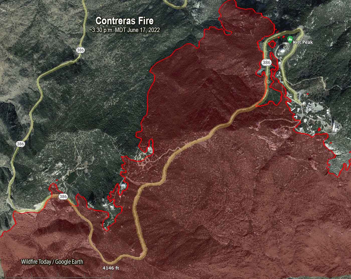
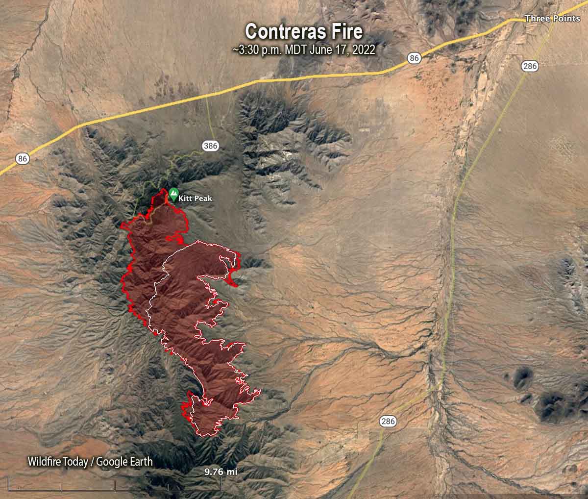
Map of the north end of the Contreras Fire at Kitt Peak at about 3:30 p.m. MDT June 17, 2022. The facilities associated with the observatories appear as white objects.
The Contreras Fire was mapped in the mid-afternoon on Friday June 17. The new information confirms reports from authorities that the fire reached the observatory facilities at Kitt Peak but it is not possible to determine from this data if there was damage to the structures. The fire came very close to the primary large cluster of buildings near the peak, as well as the other facilities to the southwest north of Highway 386, including the UArizona 12-meter Telescope.
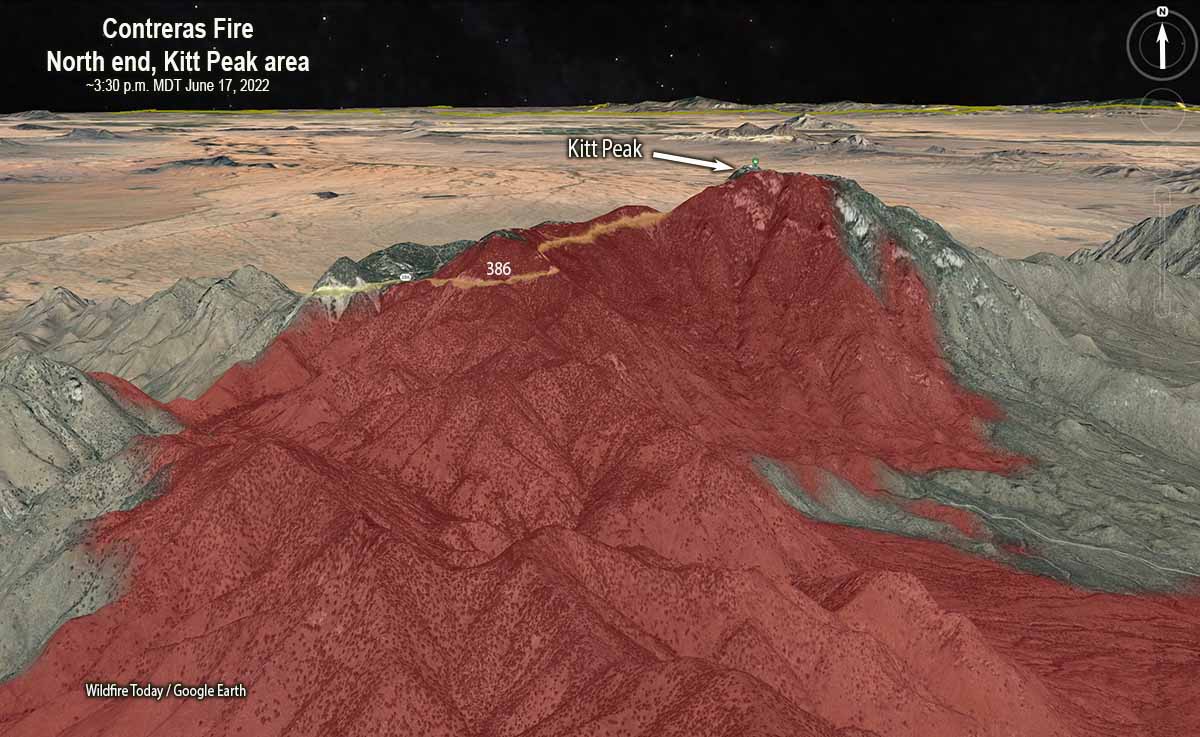
North end of the Contreras Fire, Kitt Peak, 3-D map at approximately 3:30 p.m. MDT June 17, 2022, looking north.Map of the Contreras Fire. The red line was the perimeter at about 3:30 p.m. MDT June 17, 2022. The white line was the perimeter about 24 hours before.
The growth on Thursday and Friday brings the size up to approximately 17,000 acres.
3:52 p.m. MDT June 17, 2022
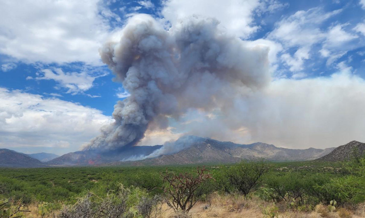
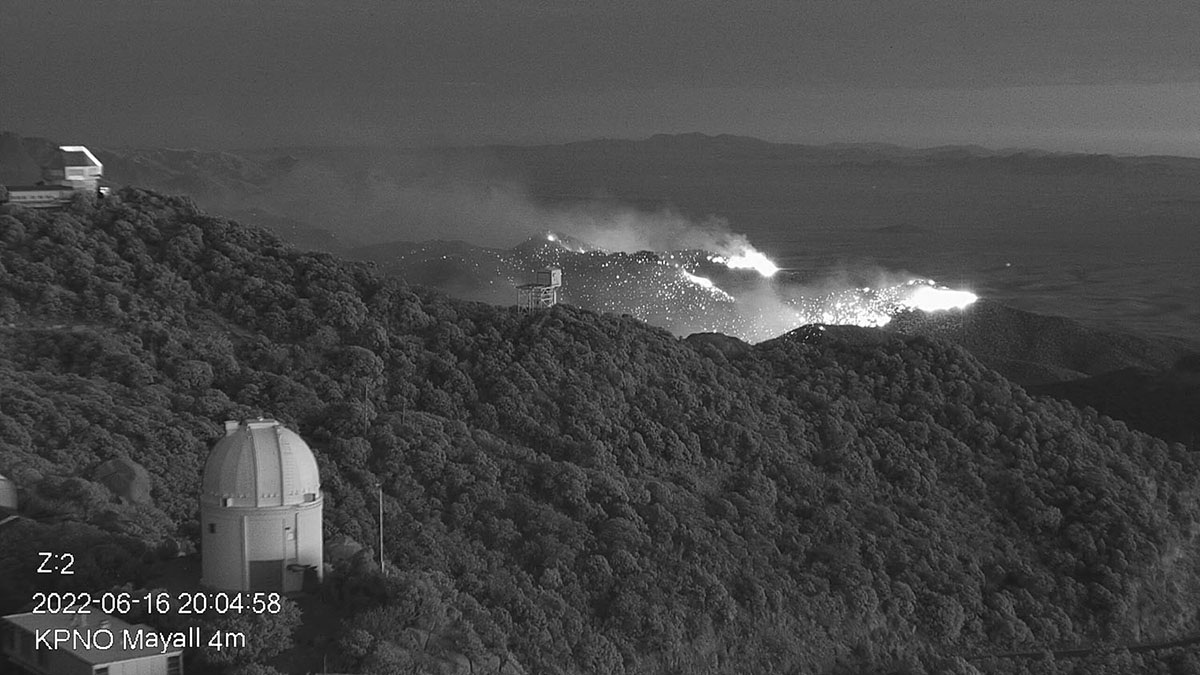
Part of the Contreras Fire burning on the slopes of the Kitt Peak mountain on Thursday evening 16 June 2022. Credit: KPNO/NOIRLab/NSF/AURA.
The Contreras Fire in Southern Arizona burned up the steep brush-covered slopes of Kitt Peak Mountain at 2 a.m. Friday crossing Kitt Peak Road (Road 386) and reaching the Kitt Peak National Observatory, a complex of more than 20 telescopes, one of the largest gatherings of astronomical instruments in the northern hemisphere. The Observatory staff said Friday, “We are working with the firefighters at the site to assess the damage and will share details about the facilities as we learn more. We remain in an active fire situation with rapidly changing conditions. The fire crested the southwest ridge where the Hiltner 2.4-meter Telescope, McGraw-Hill 1.3-meter Telescope, Very Long Baseline Array Dish, and UArizona 12-meter Telescope are located.
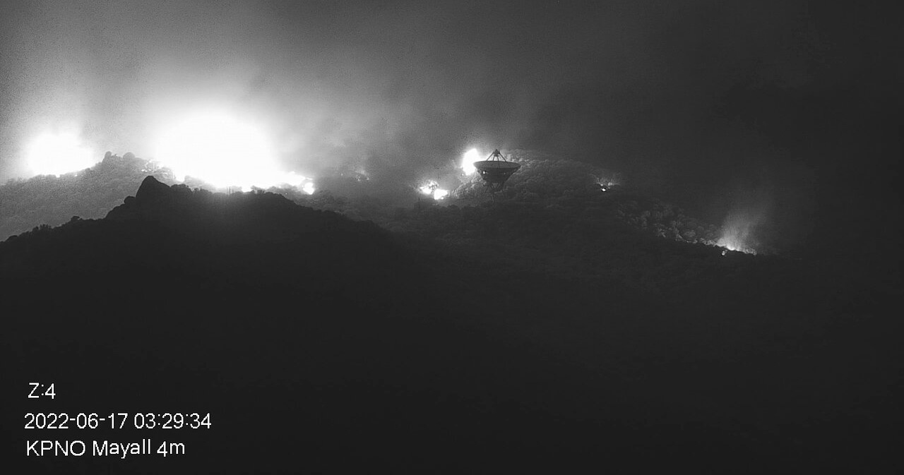
Contreras Fire burning on the slopes of Kitt Peak mountain early in the morning Friday June 17, 2022. In the foreground is NRAO’s Very Long Baseline Array Dish. Credit: KPNO/NOIRLab/NSF/AURA
The Contreras Fire started from a lightning strike on June 11. It is being managed by a Type 2 Eastern Area Incident Management Team led by Incident Commander Brian Pisarek. It is 20 miles north of the US/Mexico border and 16 miles east of Sells, AZ. As of Thursday morning it had burned about 11,500 acres.
Judging from photos, it appears that the copious fuel below and near the structures would under hot, dry, and windy conditions cause a fire moving up the slopes to create massive amounts of heat, long flame lengths, and thousands of lofted burning embers.
File photo of Nicholas U. Mayall 4-meter Telescope at Kitt Peak National Observatory. Credit: KPNO/NOIRLab/NSF/AURA/P. Marenfeld.
Clouds Thursday night prevented the scheduled infrared mapping flight, so we do not have an updated map.
Thursday night the decision was made to remove some of the trees and brush near the observatory below the southern ridge. Fire crews also cleared brush around individual domes, critical infrastructure, and propane tanks.
At 3 a.m. MDT on Friday a satellite detected heat near the observatories on the south and southwest sides of the mountain. It also detected rapid spread on the east side of the fire south of Alambre Valley.
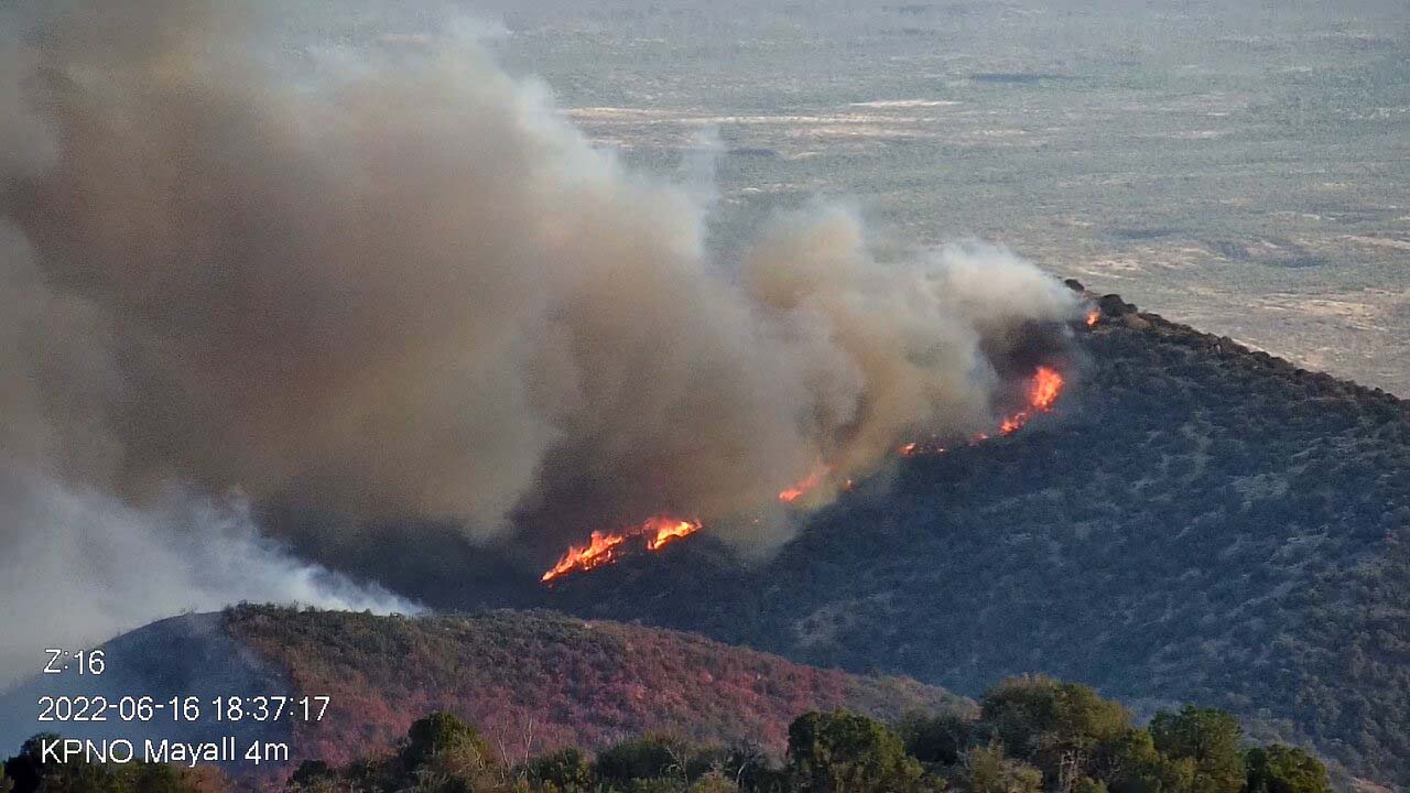
Contreras Fire burning on the slopes of Kitt Peak mountain Thursday evening June 16, 2022.
Five helicopters have been assigned to support suppression efforts today. Dense shrub cover below Kitt Peak is allowing the fire to make rapid upslope growth. Electrical supply to the Observatory has been suspended by the utility provider to mitigate unintentional sparking. More hand crews have been ordered and are expected to arrive today.
On the south end of the fire near Elkhorn Ranch, structure protection crews are utilizing fire control lines, sprinkler systems and other suppression methods to ensure the safety of the ranch community, visitors and its inholdings.
When an updated map becomes available we will add it to this article. Below is one of the maps in the June 16 article.
3-D map of the Contreras Fire looking north at 10:53 p.m. MDT June 15, 2022.
“Recruitment and retention of qualified firefighters is a critical issue for national security”
Morning briefing May 8, 2022 on the Calf Canyon – Hermits Peak Fire as firefighters break out into Divisions. USFS photo.
A survey of 708 federal wildland firefighters found that they reported dissatisfaction with recruitment and hiring processes, insufficient base salaries, poor mental health outcomes, elevated risks to health and safety, and significant effects of wildland firefighting on family status.
It was conducted by Robin M. Verble, Rachel Granberg, and Seth Person, the latter two of which are federal wildland firefighters. On their wildlandfiresurvey.com website all three are seen in photos wearing Nomex fire clothing.
“Given the ever-increasing length, extent, and intensity of wildfire season, recruitment and retention of qualified WFF is a critical issue for national security,” the researchers concluded. “Concentrated legislative, organizational, and agency efforts are needed to systemically address the issues identified in this survey: Our survey provides specific actionable items that can improve retention and recruitment, as prioritized by current federal WFFs.”
The majority of respondents had a bachelors degree or higher, had a mean base salary of $28,545 to $37,113, and 75 percent worked for the US Forest Service.
Here are a few of the survey’s many findings:
92% of the respondents stated that they needed more than 300 hours of overtime work annually to pay their bills. 27% needed over 900 hours of overtime work annually to pay their bills.
Most of the respondents disagree or strongly disagree that they have affordable childcare options.
Approximately 67% of respondents reported that they have experienced an injury or illness as a result of their work in wildland fire.
Wildland firefighters divorce at a rate 2.5 times the national average.
Approximately 60% said they have missed out on jobs because of mistakes that Human Resources made.
Conservatively estimated rates of suicidal thoughts and ideation among WFFs is 16.5%.
Respondents report rates of ADHD at approximately 4 times the national average.
Based on the survey, the researchers listed ten strategies that federal agencies can implement to improve working conditions for wildland firefighters. In the report each one is explained in detail, but here are the topics:
Provide the right pay for the right job
Recognize the strain on families
Increase mental health care accessibility and resources
Combat unhealthy and unsustainable work-life imbalance
Rectify issues with workplace safety (rates of injury, violence, and sexul assault)
Improve health insurance benefits and timely injury compensation
Reimagine the hiring process
Address chronic mismanagement at the Albuquerque Service Center (human resources and hiring)
Promote a new deal for diversity
Build organizational trust through empowering local units
Data from Granberg, R., Pearson, S., and Verble, R. 2022. Survey of federal wildland firefighters: working conditions, safety, morale, & barriers to recruitment & retention. Report. Available online at wildlandfiresurvey.com
3-D map of the Contreras Fire looking north at 10:53 p.m. MDT June 15, 2022.
Firefighters on the Contreras Fire in Southern Arizona had their work cut out for them Thursday. They were battling the wildfire on the hottest day so far of this year. The temperature at the Sasabe weather station southeast of the fire topped out at 106 degrees while the relative humidity dropped to 5 percent. The wind was out of the south and west at 5 mph gusting at 12 to 23 mph.
To see all of the articles on Wildfire Today about the Contreras Fire, including the most recent, click HERE.
In the video below the massive dust devil indicates an unstable atmosphere which can indicate conditions conducive to a plume-driven rapidly spreading wildfire.
The fire started from lightning on a remote ridge of the Baboquivari Mountains, north of the Baboquivari Peak on the Tohono O’odham Nation on Saturday, 11 June 2022. It is burning grass and brush in steep and rugged terrain that is difficult for firefighters to access. Hot and dry winds from the south and southwest are pushing the fire to the north and northeast. On Monday June 13 it had burned about 500 acres, and by Thursday morning it had grown to 11,500 acres as it moved through the drought-stressed vegetation.
Smoke visible from the Contreras Fire as seen from Kitt Peak on Thursday June 16, 2022. The image is looking south from the Nicholas U. Mayall 4-meter telescope catwalk. KPNO/NOIRLab/NSF/AURA
The fire was very active Thursday afternoon, spreading to the north, closer to Kitt Peak.
Thursday morning it was 1.5 miles south of the complex of observatories at Kitt Peak, 20 miles north of the US/Mexico border, and 16 miles east of Sells, AZ.
A Type 2 Eastern Area Incident Management Team assumed command of the Contreras Fire on June 16, under the direction of Incident Commander Brian Pisarek.
To date, aviation resources and retardant dropped from aircraft have had limited success due to heavy smoke, high winds and extremely dry fuels. Smoke from the fire is visible from Sells and Three Points, and residual effects have been reported near Tucson.
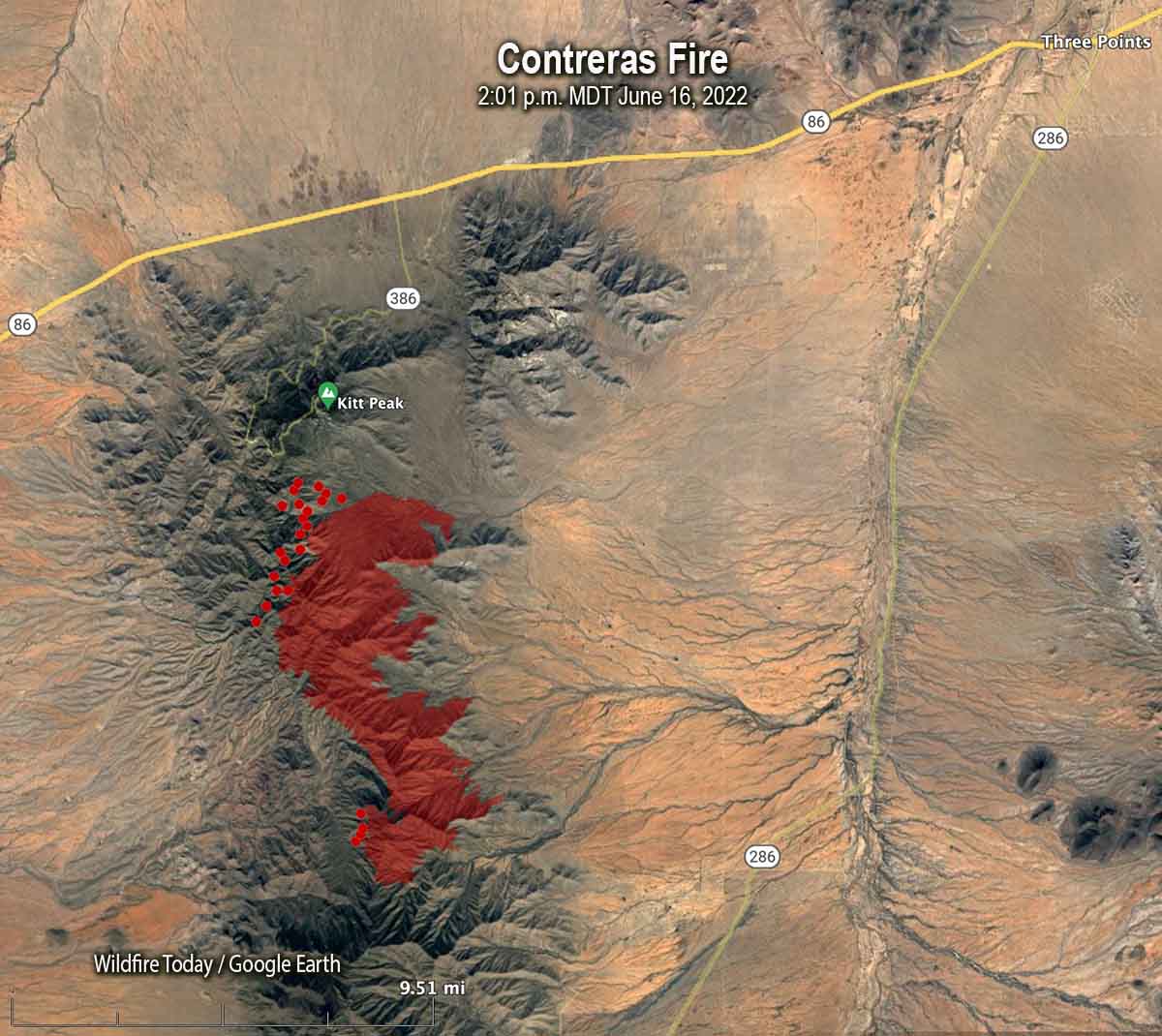
Map of the Contreras Fire. The red dots represent heat detected by a satelltie at 2:01 p.m. MDT June 16, 2022. The red line was the perimeter at 10:53 p.m. MDT June 15, 2022.
More than 1,000 fire personnel were affected by inadequate communication with the Incident Command Post
File photo. A Radio Technician sets up a portable radio repeater on the Sprague Fire in Glacier National Park in Montana, September 16, 2017. NIFC photo.
The difficulties in hiring and retaining wildland firefighters which has resulted in one-third of the Forest Service firefighter positions in California being unfilled, may not be restricted to just those who directly battle the flames. The old axiom, “amateurs think strategy, generals think logistics,” does not only apply to the military. If firefighters can’t be supplied with food, water, vehicle maintenance, hose, tools, fuel, and communications they will not be successful in a long campaign.
The concept of firefighters ensuring that before they engage, they must have adequate Lookouts, Communications, Escape routes, and Safety zones (LCES) was developed by Paul Gleason. It is shorthand for combining a list of Standard Orders fire personnel must follow to protect themselves from fireline hazards such as being entrapped in the fire. According to a report on SAFENET, there was a four-day period from May 15 until May 19 when the Communications leg of LCES was not covered adequately on the Hermits Peak/Calf Canyon Fire in Northern New Mexico.
The National Situation report for May 15 shows that in the United States that day there were 10 large uncontained fires, with all of the fires in the country being staffed by a total of 4,708 personnel. When the fire season nears its peak this summer there could be five times that many people assigned to fires. But in the middle of May there was a shortage of radio technicians and radio operators which made it impossible to set up an adequate radio communications system when it was needed on the north zone of the fire following a reorganization.
I was told by mentors as I came up through the ranks that firefighting is not an emergency — not to firefighters. It’s what we do. So when the situation gets suddenly more complex and decisions must be made and executed quickly, think calmly, act decisively, and communicate clearly. At least one of these suddenly complex situations occurred on the fire. A person needed medical treatment and extraction by air. It is referred to in the SAFENET as an incident within an incident. They are usually managed separately by an offshoot organization, and they always require efficient, robust, dependable, instant communication.
The text below is taken word for word from the SAFENET. The only change we made was to translate the acronyms.
Narrative
When Southwest Team 1 took command of the North Zone of the Hermits Peak/Calf Canyon Fire communications were unable to be linked with Incident Command Post (ICP). The zoning of the incident required the current radio communications system to be split. The North Zone remained on the current system with the South Zone moving to their own system. During this transition there were no radio techs to switch the repeater link for the North Zone and install the repeater to cover ICP. For a duration of 4 days, the link with communications at the ICP was ineffective. This was highlighted on 5/17 with a red medical that required extraction by air. During the Incident Within an Incident (IWI) communication were not able to function from ICP to the field and back. As the fire progressed, the repeater that was required for ICP was also needed to cover field personnel. Approximately, 300 personnel in the field had limited communications, with the only link established through a human repeater. During high fire behavior periods, several resources were forced to abandon tactics and leave the line because communications could not be established. The contributing factor, is the lack of radio techs available nationally. Orders were placed for radio techs days before transition and after transition. Orders for one week were returned unable to fill (UTF). Furthermore, radio operators were also unavailable. Orders were also placed for CAT personnel which was also UTF. The lack of communications personnel resulted in decrease support for the field and inability to coordinate IWI response and transport through ICP and the communications unit. About 1,200 firefighters were affected by the lack of communications with ICP.
The lack of communication personnel is limiting the “C” in “Lookouts, Communications, Escape Routes, Safety Zones” (LCES) and needs to be resolved at the national level. The trend of unable to fill communications personnel has progressively gotten worse over the last few years and will most likely result in incidents without communications in the future.
Immediate Action Taken
Field personnel had communications on the most fireline through the existing repeater system. Approximately, 25% of fireline personnel had no communications coverage which was unsatisfactorily resolved with a human repeater during the 4 days without a radio tech. Field Operations was utilized to coordinate response and transport for IWIs placing their self in a location with cell service and radio service. A radio tech was sent from the South Zone once their system was installed and working. That individual then moved to the North Zone on Day 4 to begin configuring the North Zone communication system. On 5/20, 4 days after transition, the North Zone communication system was operating providing coverage for ICP and the incident.
Other mitigations for correcting the problem took considerable time to no avail and included contacting commercial vendors, national guard and state compact agreements. The solutions did not pan out. Currently, land management agency fire organizations have no capacity for implementing a communications system on an incident without reliance on personnel outside of the fire organization.
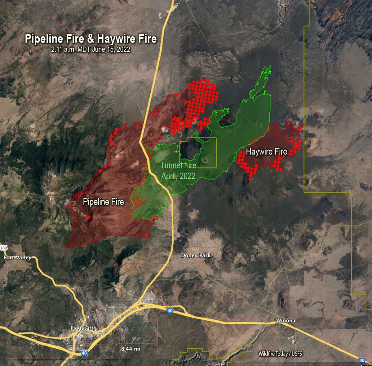
Map of the Pipeline and Haywire Fires. The red dots represent heat detected by a satellite at 2:11 a.m. MDT June 15, 2022. The red line was the perimeter at 11:15 p.m. MDT June 14, 2022.
The Pipeline Fire six miles north of Flagstaff, Arizona was active Tuesday on the northeast side, north of Sunset Crater Volcano National Monument. The rest of the blaze was relatively quiet.
The Haywire Fire was active on the south side Tuesday.
A mapping flight Tuesday night put the Pipeline Fire at about 22,000 acres, and the Haywire Fire at about 5,000 acres.
With added resources that came into Flagstaff over the last day, it put more boots on the ground. With the winds lower, it brought out the air support. On the Pipeline Fire Tuesday were two DC-10 aircraft, at least three large aircraft, and multiple helicopters and scout planes. Air support bombarded the fire through most of the day. On the Haywire Fire, fire crews saw the biggest problems. Stephen Fillmore from the Type 2 fire team from California working the fire tells KAFF News, Tuesday was a good day for fire crews. He says late in the day “the wind picked up and changed direction a little bit, which took the fire into some new fuels” which created a lot of smoke. Air attack used the rest of daylight to work on that fire.
A man was arrested Sunday in connection with starting the Pipeline Fire. He told officers he had ignited toilet paper after using it and placed it under a rock Saturday, and that he tried to put out the fire with his sleeping bag. His camp was 80 yards from where the fire started according to court documents. The probable cause of the Haywire Fire is lightning, but that still needs to be confirmed by investigators.