Fire department says Verizon’s throttling of data hampered suppression of California’s largest fire in history

The data rate for a command and control unit was reduced to 1/200th of the previous speed

cell phone towerVerizon’s throttling of data rates used by a fire department that subscribed to one of the company’s “unlimited” plans hampered the firefighters’ command and control at the fire.

While battling the Mendocino Complex, which has become the largest wildfire in the recorded history of California, the Santa Clara Fire Department deployed OES Incident Support Unit 5262, a command and control resource. Its primary function is to track, organize, and prioritize routing of resources from around the state and country to the sites where they are most needed. OES 5262 relies heavily on the internet to do near-real-time resource tracking.

This unit and other resources in Santa Clara County use web-based applications that rely on high-bandwidth, latency-sensitive exchanges of information with the public and to provide crucial public safety services.

While fighting the fire the County discovered the Verizon data connection for OES 5262 was being throttled. Data rates had been reduced to 1/200th, or less, than the previous speeds. Fire Chief Anthony Bowden wrote in a court filing that the “reduced speeds severely interfered with the OES 5262’s ability to function effectively”. The County has signed on to a legal effort to overturn the Federal Communication Commission’s repeal of net neutrality rules.

Below is an excerpt from an article in the San Francisco Chronicle:

Despite having paid for what it thought was an unlimited data plan, the Santa Clara County Central Fire Protection District saw its data flow “throttled” down to 1/200th of its usual speed as it fought the complex — now the biggest wildfire in state history — because Verizon officials said it had exceeded its plan limit, district Fire Chief Anthony Bowden wrote. This primarily hampered a specialized vehicle the department depends on to coordinate its machinery and staff in such emergencies, and Bowden said that put his battalions at risk.

Without full-speed service for the high-tech command and communications rig, which goes by the arcane name of OES 5262, Bowden wrote, “resources could be deployed to the wrong fire, the wrong part of a fire, or fail to be deployed at all. Even small delays in response translate into devastating effect, including loss of property, and, in some cases, loss of life.

One of the fire captains complained to Verizon that the command and control unit had been so hobbled that “it has no meaningful functionality”.

The battle with the fire morphed into a battle with Verizon as fire department personnel fought with the company about restoring their “unlimited” data rate. Eventually after getting various sections in Verizon and the Fire District involved, the cell phone plan in OES 5262 was upgraded to a more expensive plan that had more capability.

In the last couple of years all four major cell phone providers have advertised “unlimited” data plans. All of them ARE LIMITED in various ways, so it is inconceivable how the Federal Trade Commission lets them get away with false and misleading advertising.

An article published by C|NET on August 9 does a good job of comparing “unlimited” plans offered by Verizon, Sprint, T-Mobile, and AT&T. Of the 10 plans described, all except one have data limits, while the one that does not, limits speed used on hotspots to only 3G. Everyone is now used to 4G speeds or the even faster LTE. 5G, with much higher data rates, is just around the corner. The companies disguise how speeds will be greatly reduced after a data limit is obtained, by using words like “prioritize your data”, “deprioritized”, or just blatantly saying “customer may temporarily experience reduced speeds on these line(s) during times of network congestion”. It likely that during an emergency that affects a large number of citizens, “network congestion” will occur.

We have written many times about the “Holy Grail of Wildland Firefighting Safety”, knowing the real time location of the fire and firefighters. Depending on how these systems are configured they could rely on data delivered through the internet. If that data stream is throttled to 1/200th, is cut off, or becomes unreliable, the safety of firefighters and the public could be threatened.

The intentionally misleading use of the term “unlimited” by the four cell phone carriers is part of the problem here. The FCC and the Federal Trade Commission should do their job and stop this practice.
Fall-like weather could slow wildfires in Northern Rockies

The trend could last into next week

weather forecast northern rockies
Graphic produced by the National Weather Service office in Missoula, Montana August 21, 2018 at 8:30 p.m. MDT.

(Originally published at 9:12 a.m. MDT August 22, 2018)

When I saw the prediction from the Missoula National Weather Service office above, it got me thinking about how this cooler, possibly wetter weather is going to affect the dozens of large wildfires currently burning in the northwest United States. Two of the fires we have written about over the last couple of days, Watson Creek in Oregon and Howe Ridge in Montana, recently had small amounts of precipitation, certainly not enough to put them out, but it will absolutely slow their spread for a day or two.

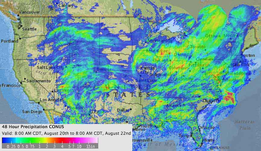
No doubt other fires were also were affected, as you can see in the map below showing precipitation over the last 48 hours. But it looks like Washington, western Oregon, and most of northern California remained dry.

weather 48-hour precipitation map
Estimated precipitation for the 48-hour period ending at 8 a.m. CDT August 22, 2018.

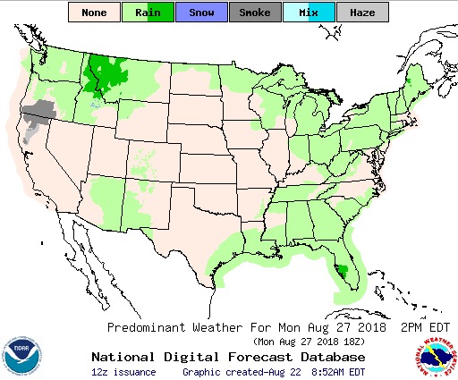
More rain is expected in the Northern Rockies into next week. Below is the forecast for precipitation on Monday afternoon, August 27. The “haze” shown in California and Oregon is presumably smoke from the Mendocino Complex of Fires.

precipitation August 27 2018
Predicted precipitation for August 27, 2018.

Next are the predictions for precipitation and temperature August 27 through 31.

Continue reading “Fall-like weather could slow wildfires in Northern Rockies”

Watson Creek Fire spreads to within 6 miles of Paisley, Oregon

The fire has burned 32,104 acres

Above: Watson Creek Fire, August 19, 2018. Photo by Barry Shullanberger

(Originally published at 2:45 p.m. PDT August 21, 2018)

During the six days the Watson Creek Fire has been spreading through the Fremont-Winema National Forest in south-central Oregon it has burned 32,104 acres 6 miles southwest of Paisley. On Tuesday it was active along most of the perimeter, but grew substantially on the west and southeast sides.

Among the locations on the fire being worked on by firefighters Tuesday were the north flank, Slide Lake, and the 3360 and 3315 Roads around Hadley Butte. Firefighters are facing challenges of hazardous trees, snags, dead and down lodgepole pine, and difficult terrain.

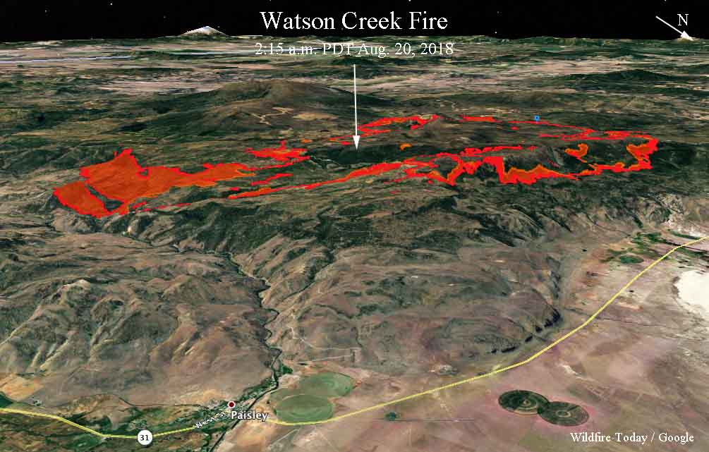
3-D Map Watson Creek Fire
3-D map of the Watson Creek Fire, looking southwest, showing the perimeter (the red line) at 2:15 a.m. PDT August 21. The red shaded area represents intense heat at that time. Click to enlarge.

A thunderstorm Monday night generated a few lightning strikes east of the fire area. Rain with the storm over the fire aided firefighting efforts overnight. The temperature Tuesday will be milder with 20 to 30 percent relative humidity. Winds should be out of the north to northeast with afternoon gusts up to 15 mph with variable wind direction.

The evacuation order for the Lakeview Estates neighborhood just north of Campbell and Deadhorse Lakes in the Fremont-Winema National Forest is still in effect Tuesday.

Resources assigned to the fire include 15 hand crews, 34 fire engines, and 5 helicopters, for a total of 556 personnel.

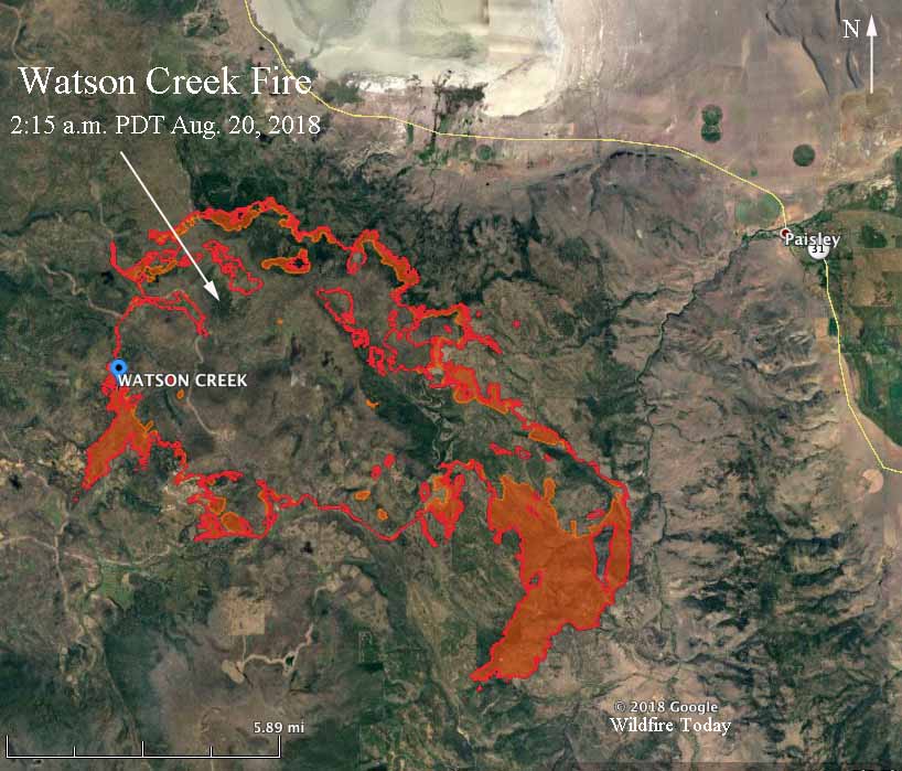
Map Watson Creek Fire
Map of the Watson Creek Fire showing the perimeter (the red line) at 2:15 a.m. PDT August 21. The red shaded area represents intense heat at that time. Click to enlarge.

Some areas in the Northwest have “unhealthy” air quality

The primary cause is smoke from wildfires

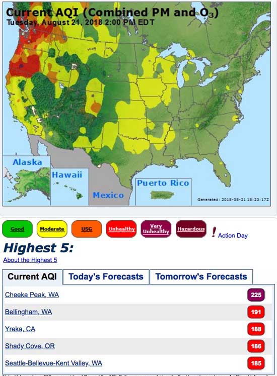
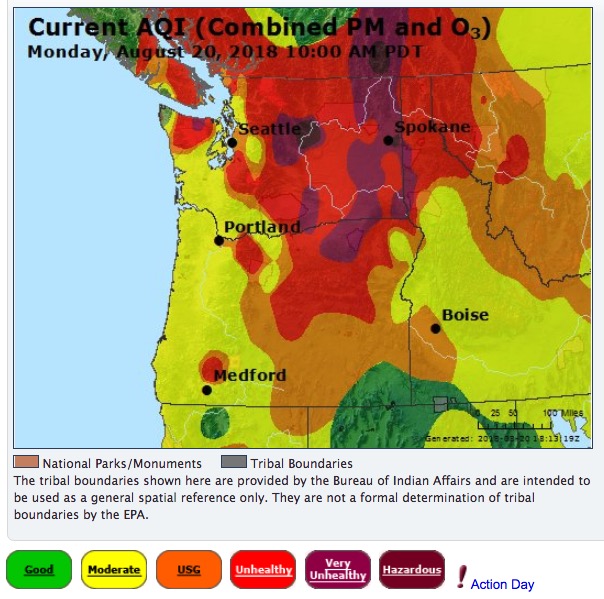
Air Quality Index smoke
Air Quality Index, August 21, 2018. AirNow.gov

Smoke from wildfires continues to plague areas of Washington, Oregon, California, Idaho, Nevada, and Wyoming. According to AirNow.gov, the five cities in the United States with the worst air quality Tuesday were:

  • Cheeka Peak, Seattle-Bellevue-Kent Valley, and Bellingham in Washington;
  • Yreka, California; and
  • Shady Cove, Oregon.

The information below from the National Weather Service reinforces the advice that the least expensive dust masks available at the local hardware store (or a bandana tied over your face) provide almost no protection from smoke. The microscopic particles in smoke from vegetation fires are so small that they cruise right through a mask that may work fine for filtering out dust from working with wood, for example.  As they said, choose a mask called a “particulate respirator” that has the word “NIOSH” and either “N95” or “P100” printed on it.

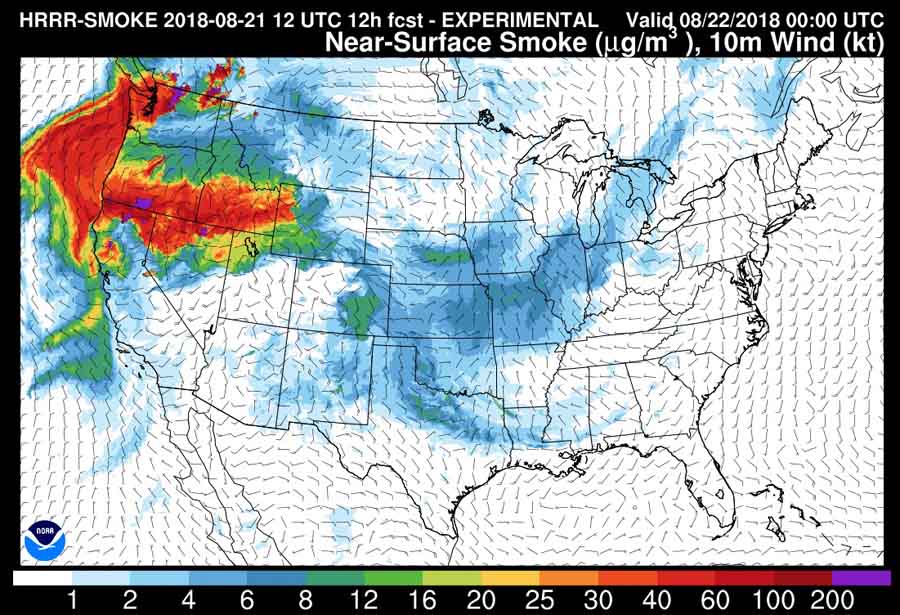
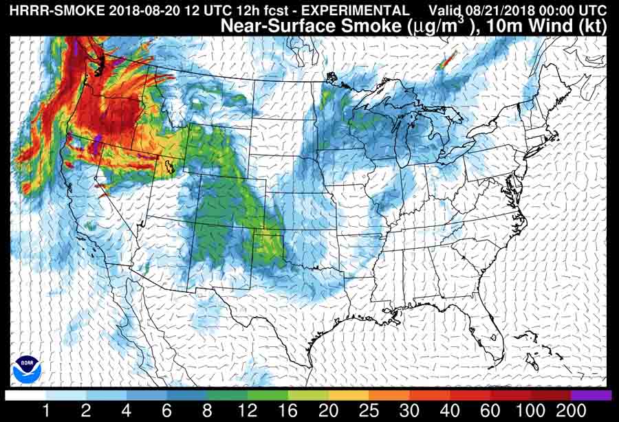
map wildfire smoke
The forecast for the distribution of smoke from wildfires at 6 p.m. MDT August 21, 2018.
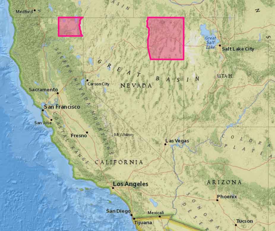
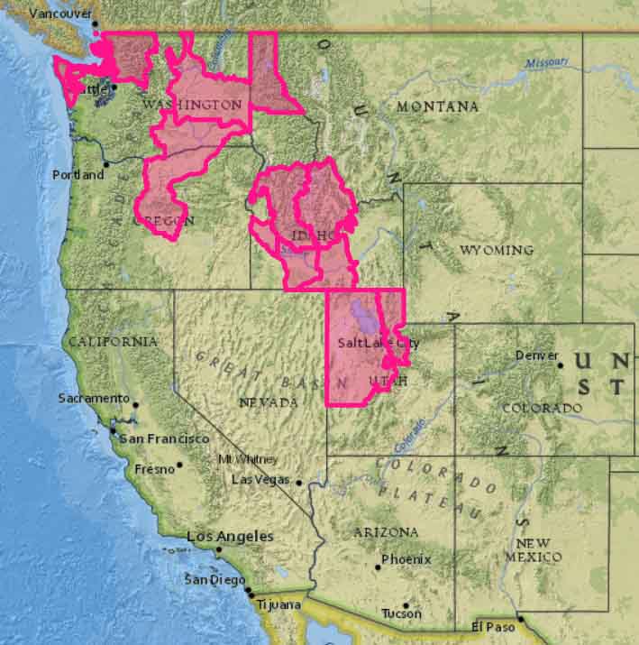
Red Flag Warnings, August 21, 2018
Red Flag Warnings, August 21, 2018.

Fires grow in Oregon and Northern California

Above: This natural-color satellite image was collected on July 18, 2018. Actively burning areas, detected by thermal bands, are outlined in red. NASA image courtesy NASA/Goddard Space Flight Center Earth Science Data and Information System (ESDIS) project.

By Lynn Jenner, NASA

In Oregon there are 15 large ongoing fires and 231,278 acres have been burned as of August 20, 2018. The satellite image above shows several of the larger fires in both Oregon as well as California. California has 10 large fires including the two largest to date, the Ferguson fire and the Mendocino Complex. California has seen 716,276 acres burned this year.

In Oregon, the Taylor Creek and Klondike Fires are burning in the Rogue River-Siskiyou National Forest. Both fires were started by lightning on July 15. These two fires were split into zones on Saturday, Aug. 18. The fires are now referred to as “Taylor Creek and Klondike East Fires,” managed by the Alaska Incident Management Team and the “Klondike West Fire” which is managed by California Interagency Incident Management Team 4. California Interagency was called in to continue with the aggressive fight to fully suppress the fire. That will allow the Alaska Incident Management Team to focus its effort on controlling the southeast corner of the fire that is directly threatening the communities of Selma and Cave Junction. As of the morning of Aug. 20, the Taylor Creek Fire is estimated 52,588 acres and is 79 percent contained. The Klondike Fire is estimated at 72,074 acres and is 28 percent contained.

The Miles Fire is the new name for the fire previously named the Sugar Pine. The Miles Fire and Sugar Pine fire have merged. On Sunday July 15, lightning started hundreds of fires across Southwest Oregon. The Miles fire has currently affected 47,015 and is 38% contained at present. Today some instability will swing into the area with the threat of some isolated showers or a thunderstorm. Continued smoke in the valleys will moderate daytime temperatures but will also continue to affect air quality for local communities.

The Watson Creek fire is currently burning on the Paisley Ranger District of the Fremont-Winema National Forest. It was discovered Wednesday, August 15 at 2:15 p.m. The fire is currently burning in heavy fuels, primarily dead and down lodge pole pine. This fire has burned 25,778 acres. The cause of the blaze is under investigation.

In California, right on the Oregon/California line between Happy Camp, CA and Cave Junction, OR is the Natchez fire which has been burning since lightning struck on July 15, 2018. The 697 personnel assigned to the incident are working to implement suppression actions that will most effectively and safely limit fire growth. Currently 20,275 acres have burned and the fire is 70% contained. Fire area closures are in place on the Rogue River-Siskiyou and Klamath National Forests.

The Stone fire began on August 15 with a lightning strike. The current fire size 22,610 acres. Weather concerns for this fire include extremely dry conditions and low humidity. The fire was active last night and fire crews made great progress along the fire edge to control the fire spread and provide structure defense.