One dead, 50,000 acres burn in Substation Fire

Northern Oregon southeast of The Dalles

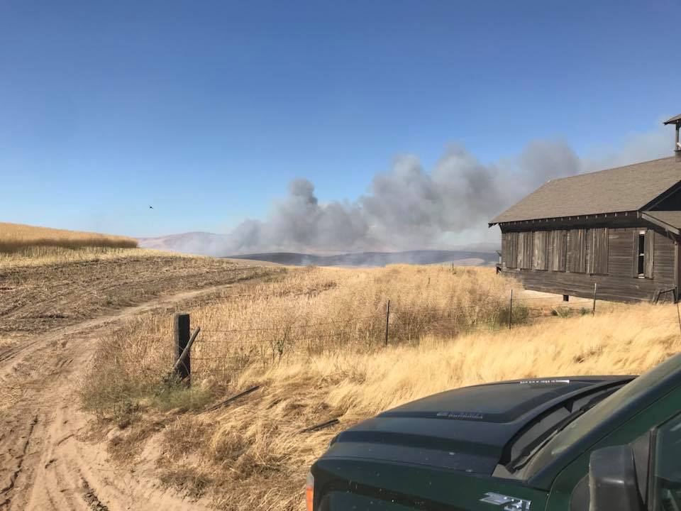
Above: Substation Fire. Incident Management Team photo, July 18, 2018.

(Originally published at 6:33 a.m. PDT July 19, 2018)

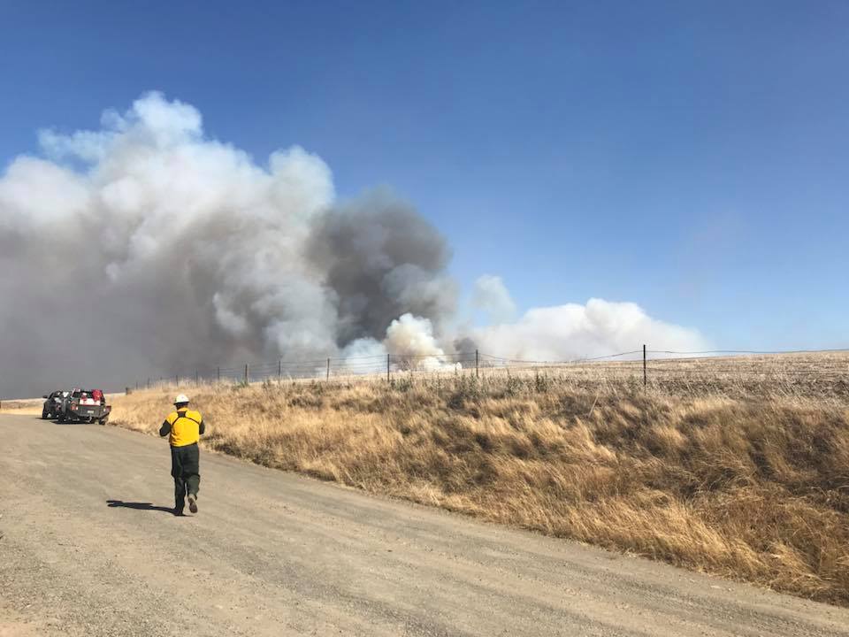
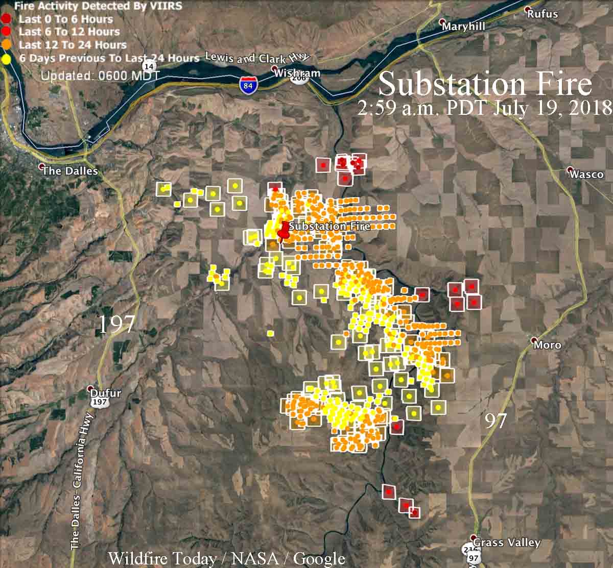
Since the Substation Fire started July 17 southeast of The Dalles, Oregon it has claimed the life of one person and burned over 50,000 acres. The fire has blackened an area approximately 18 miles long by 8 miles wide, and has jumped the Lower Deschutes River in at least two places.

The Wasco County Sheriff’s Office reported that at 1:30 p.m. on July 18 deputies answered a call about a burnt tractor. They found the operator a short distance away, deceased, apparently killed by exposure to the fire. The operator may have been attempting to suppress the fire by using the tractor and disk to construct a fireline. The release of the person’s name is pending notification of next of kin.

The Sheriff’s Office has the most current information about the areas under evacuation orders. They have boats patrolling the river to notify hikers and boaters.

Officials have closed Highway 97 from Biggs Junction to Highway 197.

The Governor declared the fire a conflagration Wednesday, which allows the state fire marshal to mobilize firefighting resources.
map substation fire
Map showing heat on the Substation Fire detected by satellites as late as 2:59 a.m. PDT July 19, 2018. The red icons are the most current. It is likely that in some areas light fuels such as wheat and grass burned and cooled in between satellite overflights, therefore was not detected by the sensors. Click to enlarge.

The area is under a Red Flag Warning on Thursday. The forecast for the fire area calls for 78 degrees, 25 percent relative humidity, and afternoon winds out of the northwest of 19 gusting to 27 — not good news for firefighters.

A Type 1 Incident Management Team (Schulte) has been assigned to the fire.

One structure has been destroyed, an often photographed historic home.

Substation Fire
Substation Fire. Incident Management Team photo, July 18, 2018.
Substation Fire
Substation Fire. Incident Management Team photo, July 18, 2018.

The video below was uploaded by the Incident Management Team to Facebook on July 18, 2018.

Lightning leaves behind many fires in Oregon

Approximately 2,800 lightning strikes since Friday have caused 163 wildfires in Oregon

Above: The red dots represent wildfire heat in Oregon detected by a satellite at 3:34 a.m. PDT July 18, 2018.

(Originally published at 3:56 p.m. PDT July 18, 2018)

Thunderstorms over the weekend have created a great deal of work for firefighters in Oregon. At least 163 wildfires were detected in the state after 2,800 lightning strikes peppered the area since Friday. By Wednesday morning the numbers have settled down to 47 fires that have burned over 22,000 acres, according to the Department of Forestry Wednesday morning. However since those numbers were released the Substation Fire (see below) has been mapped at 36,000 acres. Dozens of fires are burning in the southwest corner of the state on the Umpqua, Rogue River, Winema, and Siskiyou National Forests.

The lightning was predicted days in advance. Many of the land management agencies proactively imported additional firefighting resources to deal with the anticipated workload following the lightning bust.

In Central Oregon firefighters are battling the 1,300-acre lightning-caused Cemetery Fire 12 miles southwest of Paulina. It started July 16 and is burning on the Ochoco National Forest and lands protected by the BLM and the State of Oregon.

Substation fire Deschutes River
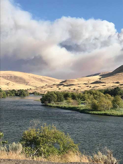
The Substation Fire has jumped the Deschutes River in Oregon at least twice. Photographer unknown. Uploaded to Facebook July 18, 2018.

In north-central Oregon a few miles south of the Washington state line and The Dalles, the Substation Fire that started Tuesday has blackened about 36,000 acres and has jumped the Deschutes River at least twice. Evacuations are taking place in Sherman County. Officials have not released the cause of the fire.

The video below, described as “incredible, horrifying” by KATU News, shows a fire engine on the Substation Fire making an “inside-out attack”, or “attacking from the black”. This is a well known tactic and can be less hazardous than driving in flammable vegetation while making a mobile attack.

Ferguson Fire spreads south, adds 5,000 acres

The fire has burned 17,319 acres northeast of Mariposa, California

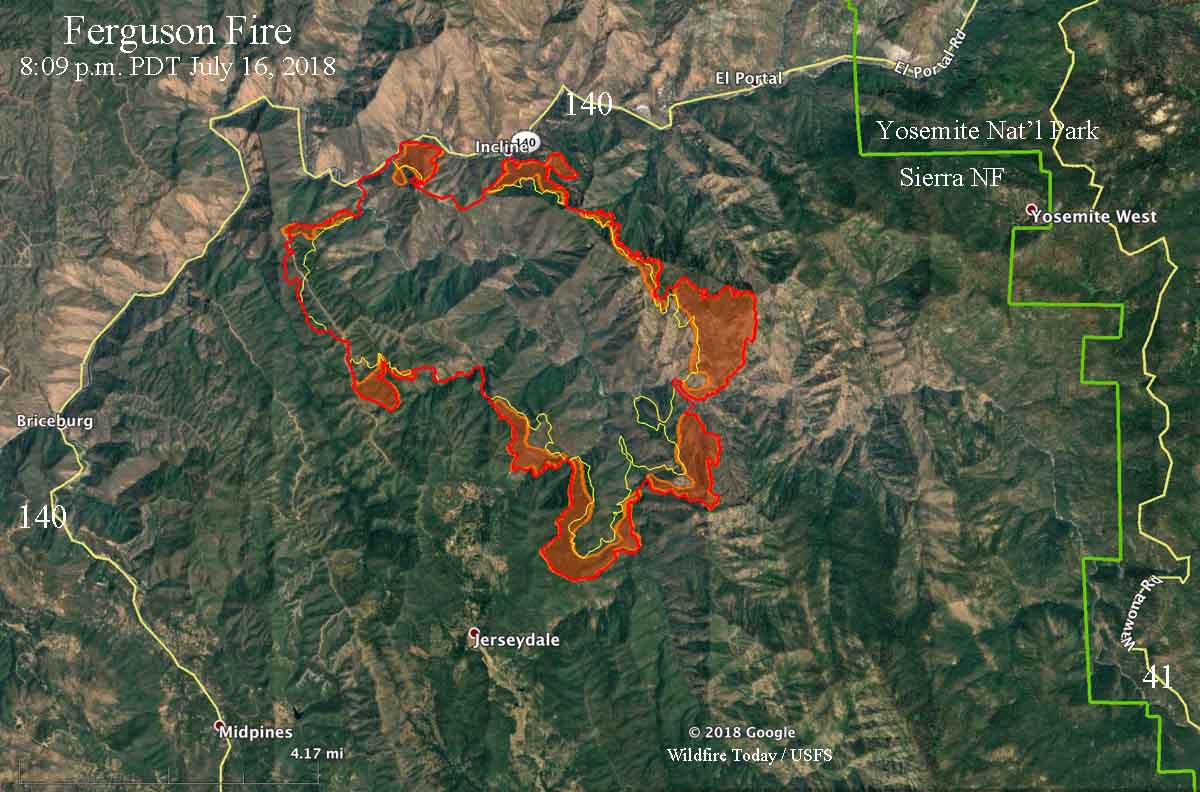
Above: Map showing the perimeter of the Ferguson Fire at 11:34 p.m. PDT July 17. The red shaded areas represent intense heat at that time. The yellow line was the perimeter two days before.

Again Tuesday the Ferguson Fire spread in all directions. On the north side firefighters are attempting to tie it in with one of the routes that leads into Yosemite National Park, Highway 140. The highway has been closed west of El Portal since the fire started on July 13 and there’s no indication when it will reopen. Other routes into the park are open, but Yosemite Valley has severely degraded visibility due to heavy smoke from the fire.

Most of the growth Tuesday and Tuesday night was on the southeast and southwest sides. The high pressure that has been dominating the area is causing an inversion that has been preventing the smoke from blowing out of the area, holding it close to the ground. This makes it difficult or impossible to use fixed wing air tankers until the inversion breaks in the late afternoon when the inversion lifts.

CLICK HERE to see all of the articles on Wildfire Today about the Ferguson Fire, including the most recent.

On Tuesday the fire backed down Ferguson Ridge and became well established in the Sweetwater Creek drainage and behind Cedar Lodge. Crews worked Tuesday night to secure line around Cedar Lodge and Indian Flat. The power line has been repaired, and electrical service has been restored to the area. Work on Tuesday involved improving containment lines, as well as protecting the communities of Jerseydale, Mariposa Pines. and Yosemite West.

Judging by the number of resources assigned, the Ferguson Fire is becoming a very large incident. There are a total 1,850 personnel, including 158 engines, 5 water tenders, 5 helicopters, 44 hand crews, and 16 dozers. A mapping flight Tuesday night determined it has burned 17,319 acres.

The weather on Wednesday will again be hot and dry, and the inversion will most likely keep air tankers grounded until late afternoon.

Ferguson Fire grows to over 12,000 acres

The fire has caused evacuations west of Yosemite National Park in California

(Originally published at 8:07 a.m. PDT July 17, 2018)

map Ferguson Fire
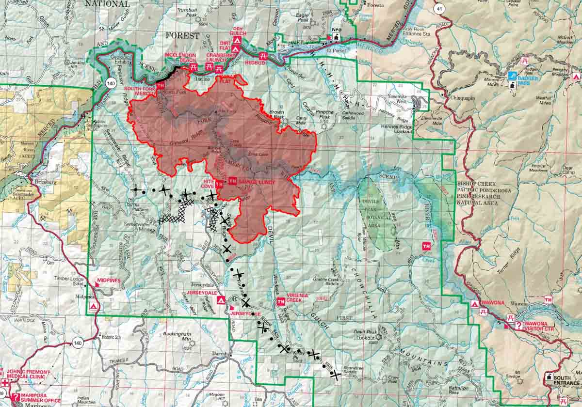
Map produced by the Incident Management Team, July 17, 2018. The line with the dots and plus signs represents a proposed dozer line. Click to enlarge.

For days the Ferguson Fire has been marching across the remote, steep terrain west of Yosemite National Park. On Monday it grew on all sides to some extent, with most of the additional blackened acres being added on the south and east sides.

Areas that are under mandatory evacuation orders include Incline Road from Clearing House to the last BLM campground; Jerseydale/Mariposa Pines; Cedar Lodge/ Indian Flat Campground, Savage’s Trading Post and Sweetwater Ridge.

CLICK HERE to see all of the articles on Wildfire Today about the Ferguson Fire, including the most recent.

Many areas are under an advisory or potential evacuation order should conditions change. A few examples are Yosemite West, National Park Service El Portal Complex, and Old El Portal. The Mariposa County Sheriff’s office has more current details about evacuation orders.

map Ferguson Fire
Map with red shaded areas indicating areas of intense heat at 9:08 p.m. PDT July 16, 2018.

Monday morning the incident management team announced that overnight mapping flights determined that 12,525 acres have burned in the Ferguson Fire.

Road closures:

  • Highway 140 from Abbie Rd in El Portal to 14 miles north of Mariposa;
  • Incline Road;
  • River Road from Briceburg to the gate at Railroad Flat;
  • Hites Cove / Jerseydale Road.

Approximately 1,486 personnel are assigned to the fire, including 118 engines, 5 water tenders, 4 helicopters, 39 hand crews, and 16 dozers. Air tankers are assigned as needed and as smoke and visibility allow. We have seen up to eight being used at the same time, ranging from the 1,200-gallon S2T’s to the 11,600-gallon DC-10’s.

Smoke forecast for Monday, July 16

The map shows the prediction for the distribution of smoke from wildfires at 6 p.m. MDT July 16, 2018. Much of it is generated at the Ferguson Fire west of Yosemite National Park in California.

Fire whirl, or waterspout, or fire tornado?

Spectacular video at a fire near Blythe, California

Above: screenshot from the video below.

Chris Mackie posted this video on July 15, 2018 of spectacular fire behavior at a wildfire on the Arizona side of the Colorado River near Blythe, California. It is not uncommon to see dust devils and fire whirls during unstable weather conditions on a fire, but as you can see beginning at about 1:10 the rotating vortex over this fire intensifies into what some might call a fire tornado (or “firenado”) as trees are uprooted and debris is thrown into the water as it moves over the river (and transforms into a waterspout?).

We have written about similar phenomenons several times on Wildfire Today. Here is an excerpt from a 2016 article, “Defining fire whirls and fire tornados”:


“The news media sometimes calls any little fire whirl a “fire tornado, or even a “firenado”. We found out today that these and related terms (except for “firenado”) were, if not founded, at least documented and defined in 1978 by a researcher for the National Weather Service in Missoula, David W. Goens. He grouped fire whirls into four classes:

  1. Fire Devils. They are a natural part of fire turbulence with little influence on fire behavior or spread. They are usually on the order of 3 to 33 feet in diameter and have rotational velocities less than 22 MPH.
  2. Fire Whirls. A meld of the fire, topograph, and meteorological factors. These play a significant role in fire spread and hazard to control personnel. The average size of this class is usually 33 to 100 feet, with rotational velocities of 22 to 67 MPH.
  3. Fire Tornadoes. These systems begin to dominate the large scale fire dynamics. They lead to extreme hazard and control problems. In size, they average 100 to 1,000 feet in diameter and have rotational velocities up to 90 MPH.
  4. Fire Storm. Fire behavior is extremely violent. Diameters have been observed to be from 1,000 to 10,000 feet and winds estimated in excess of 110 MPH. This is a rare phenomenon and hopefully one that is so unlikely in the forest environment that it can be disregarded.”