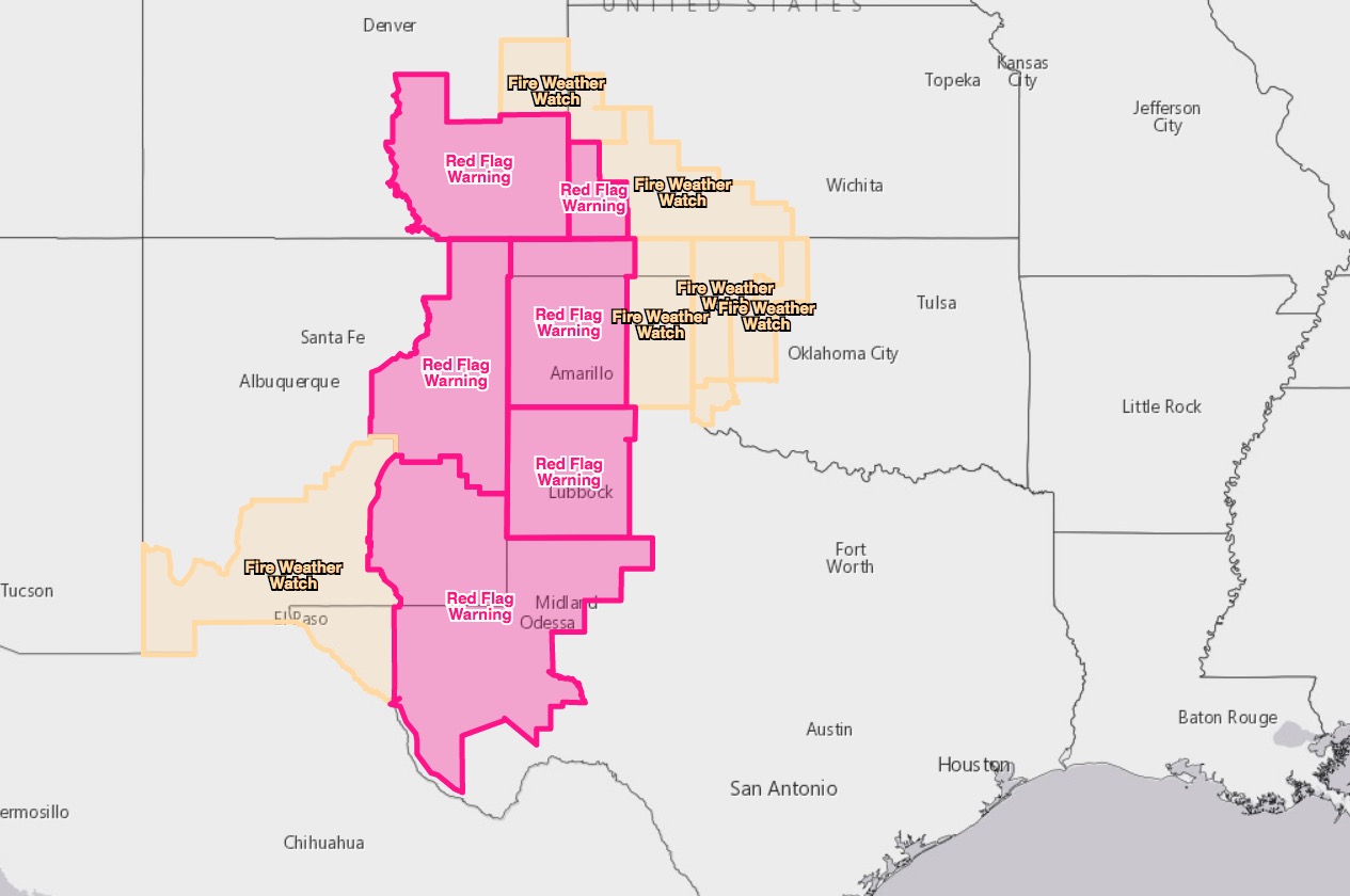
Red Flag Warnings in six states, March 22, 2018

wildfire red flag warnings

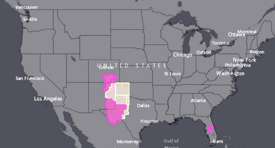
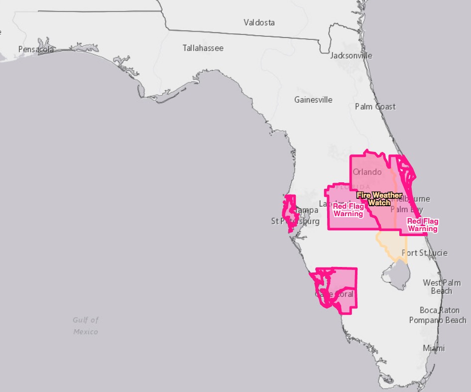
The National Weather Service has issued Red Flag Warnings and/or Fire Weather Watches for areas in Colorado, New Mexico, Oklahoma, Kansas, Texas, and Florida.
wildfire red flag warnings

The Red Flag Warning maps were current as of 8:23 a.m. MDT on Thursday. Red Flag Warnings can change throughout the day as the National Weather Service offices around the country update and revise their forecasts.

Comprehensive fire funding fix could be passed this week

The new system is included in the proposed omnibus legislation

Above: Thomas Fire, Ventura, California, Los Padres National Forest, 2017. USFS photo.

(Originally published at 8:09 a.m. MDT March 22, 2018)

After years of dithering, Congress appears to be on track to finally significantly change the way wildfires are funded, no longer robbing dollars from fire prevention or totally unrelated accounts to pay for emergency fire suppression. One insider in Washington calls it the long-anticipated “comprehensive funding fix”.

The changes are part of the omnibus legislation that likely will be voted on on Friday. The bill also funds most of the government, which will have to shut down Saturday if it does not pass. Of course anything could happen between now and then, but this is the closest we have been to a meaningful solution.

(UPDATE: the legislation became Public Law No: 115-141 on March 23, 2018. See section 102.)

If passed it would begin in fiscal year 2020 and run through 2027, improving the two aspects of fire funding that have created major problems:

  1. In years when fire suppression costs are very high, it would use a budget cap adjustment to fund a new account which will receive an extra $2.3 to $3.0 billion a year. The amount will increase by $100 million each year. This should reduce the need to rob money from unrelated accounts in bad fire seasons. Money from the account would only be used after funds from usual firefighting accounts are depleted.
  2. It will freeze the 10-year average computation of fire suppression costs at the 2015 level, $1.4 billion. This is even more important than the first change. Congress directs the Forest Service to fund the fire organization at the 10-year average of costs. That would be fine, except that the total budget for the FS remains the same year after year, while fire costs keep increasing. So even before the fire season starts, the agency has to take money from other accounts to give to fire management. And, this money is not later paid back, unlike the funds that are taken later in the year to pay for a bad fire season.

These TWO changes are why the insider calls this a “comprehensive funding fix”. Simply creating a new, unconnected account for emergency fire suppression would be only part of a solution.

But if the total budget for the Forest Service continues to be locked in at the same amount year after year, funding the fire organization at the 2015 10-year average is still going to be very difficult. The third part of the fire funding fix would be to stop cutting, in real dollars, the amount appropriated to the Forest Service.

Other provisions in the omnibus bill would increase the budget for the National Park Service by 8 percent and include $154 million to apply toward the $11.6 billion infrastructure repair backlog.

The legislation also reduces environmental analysis procedures on projects that treat hazardous fuels.

The press releases are flying as politicians praise, and in some cases, take partial credit for the changes in fire funding. The two Colorado Senators, Cory Gardner and Michael Bennet, are in favor of the changes:

“The pressures that wildfires have brought to the West, as well as the challenges of climate change and development, the antiquated way we pay for firefighting needed dramatic change,” Sen. Bennet (D) said in a news release. “This bipartisan fix transforms and modernizes the Forest Service’s capacity to restore forest health and mitigate and fight wildfires.”

Sen. Gardner (R) also said the funding bill will go a long way to help federal agencies tasked with fighting fires.

“Year after year, much of the West is forced to deal with horrible wildfires that burn millions of acres, and funding that should be applied to fire prevention and mitigation projects is instead spent by the Forest Service fighting these fires. Our provision will ensure the Forest Service has the necessary funding for cleanup and prevention efforts that will help reduce the amount of catastrophic wildfires the Forest Service has to fight,” Gardner said.

The Senators in Montana, Oregon, and Idaho issued similar statements.
Legislation would provide “Holy Grail” for wildland firefighters

Senate Bill 2209 would enhance situational awareness for firefighters

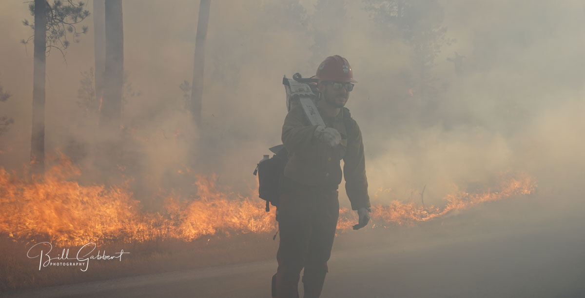
Smoky conditions on the Legion Lake Fire
Smoky conditions on the Legion Lake Fire in Custer State Park in South Dakota, December 12, 2017. Photo by Bill Gabbert.

Two U.S. Senators are co-sponsoring a bill that would enhance the safety and situational awareness of wildland firefighters. Senate Bill 2290 would be an important step toward what we have called the “Holy Grail of Firefighter Safety”. This concept would provide the real time location of a wildfire and the resources working on the incident. Too often fatalities have occurred when firefighters did not know where the fire was or overhead personnel were not aware of the position of firefighters who were endangered by the quickly spreading fire. Or both at the same time.

The legislation would require the Departments of Interior and Agriculture to jointly develop and operate “a tracking system to remotely locate the positions of fire resources assigned to Federal Type 1 Wildland Fire Incident Management Teams”.

A complimentary requirement in the bill is “unmanned aircraft systems to [supply] real-time maps, detect spot fires, assess fire behavior, develop tactical and strategic firefighting plans, position fire resources, and enhance firefighter safety”.

The sponsoring Senators are a Democrat and a Republican, Maria Cantwell (D-WA) and Cory Gardner (R-CO). Since the bill was introduced January 10, 2018 no further action has taken place and no additional Senators have signed on, so it appears there is not much momentum pushing it through the process.

Here are the first two paragraphs in a press release issued by Senator Gardner’s office:

Washington D.C. —U.S. Senators Cory Gardner (R-CO) and Maria Cantwell (D-WA) introduced the Wildfire Management Technology Advancement Act of 2017, a bill designed to bring firefighting agencies into the 21st century.

This bill will increase firefighter safety by requiring the Forest Service and the Department of the Interior to begin providing GPS locations for crews on wildfires and to begin using Unmanned Aircraft Systems to scout out and map wildfires in real-time. Wildfire Today refers to the simultaneous use of mapping aircraft and GPS locators as the ‘Holy Grail’ of firefighter safety.

It is nice to see that at least two Senators are thinking about firefighter safety.

Thanks and a tip of the hat go out to Bean.
Typos or errors, report them HERE.

Three firefighters suffer burns on Arizona fire

All three are expected to make full recoveries

Three firefighters are recovering from burn injuries they sustained while working on a wildfire in Southwest Arizona over the weekend.

On Friday, March 16 two State Forestry firefighters were burned after falling into an ash pit on the Laguna Fire, 14 miles northeast of Yuma.

One firefighter suffered 2nd and 3rd degree burns and was flown to the Arizona Burn Center in Phoenix where he remains in the hospital. The other was treated at a Yuma-area hospital and released.

On Saturday, a third firefighter was injured on the same fire. He suffered minor burns and was also treated at the hospital and released.

Two of the firefighters are part of State Forestry’s Phoenix Crew. The third firefighter is a member of State Department of Corrections’ Yuma Crew.

“Firefighter safety is our number one priority at all times. The accidents are currently under review and being investigated by the department. We ask that you please keep all of our firefighters in your thoughts,” said State Forester Jeff Whitney.

All three are expected to make full recoveries.

The 15-acre Laguna Fire started Thursday, March 15th and the cause is under investigation.

Thanks and a tip of the hat go out to Jason and Tom.
Typos or errors, report them HERE.

69 homes believed destroyed in New South Wales bushfire

Above: A fire burns structures in Tathra, New South Wales. Photo credit: NSW Rural Fire Service.

(Updated at 8:30 a.m. MDT March 19, 2018, US time)

At least 69 homes were destroyed and 39 damaged in the bushfire that spread into the coastal community of Tathra in New South Wales according to the Rural Fire Service.

As the fire ran into the town many residents took refuge on the beach, but very strong winds, smoke, and blowing sand convinced some to leave and head for the evacuation center in Bega.

The fire has burned approximately 1,200 hectares (2,965 acres).

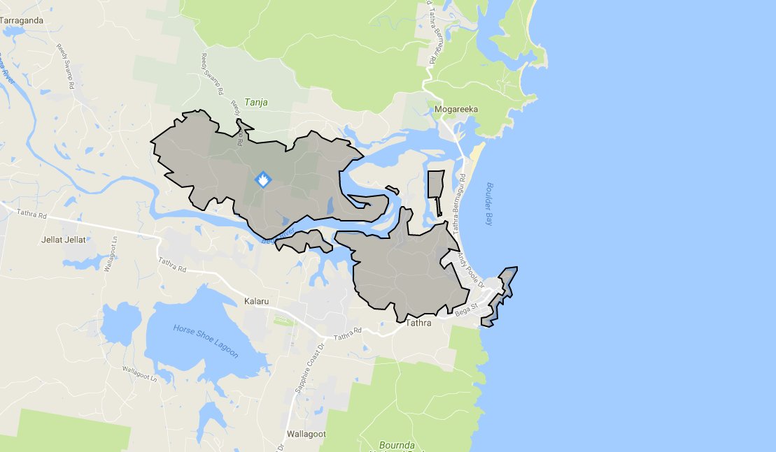
map fire tathra
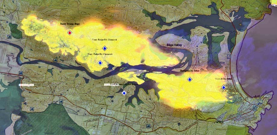
Map of the fire near Tathra, New South Wales. NSW RFS.


(Originally published at 11:03 a.m. MDT March 18, 2018, US time)

A fire that started southeast of Bega, New South Wales has burned east to the Pacific coast destroying homes in its path. The official tally of the affected structures is not available but Campbell Fuller, communications director of the Insurance Council of Australia, said “We are hearing several dozen properties” burned.

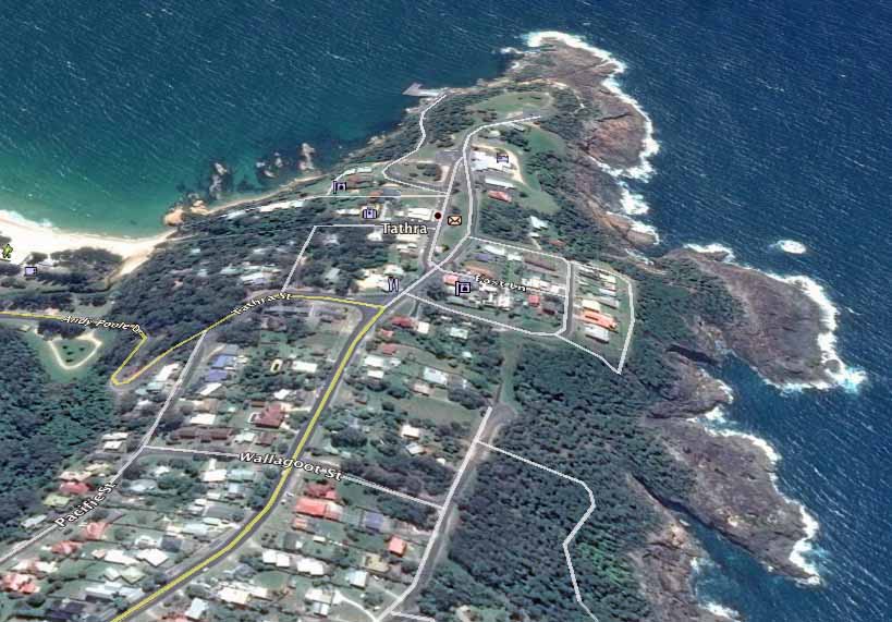
map bushfire Tathra new south wales
Google Earth file photo of the area in Tathra NSW affected by a bushfire. Compare this image to the one at the top of the article.

From the Daily Telegraph:

Earlier on Sunday night Bega Valley Shire Council mayor Kristy McBain said up to 35 homes had been lost and the concern was now about people stuck in Tathra as the roads in and out of the town were closed.

Many of the destroyed homes were in the small coastal community of Tathra, population 1,622. After the fire ran east for 5 miles (8 km) from the Bega area to the coast, jumping the Bega River, the wind shifted to come out of the south, slowing the spread. Officials advised residents to continue to monitor conditions and be prepared to enact their bush fire survival plan should the fire threaten again. The evacuation center is at Bega Showground.

map bushfire Tathra new south wales
Map of the bushfire between Bega and Tathra NSW. Map by NSW RFS.

The NSW Rural Fire Service video below shows Air Tanker 390 making a drop in Tathra.

The latest size of the fire released by the Rural Fire service at 23:10 March 18 local time was 1,000 hectares (2,470 acres).

bushfire Tathra new south wales
Air Tanker 390 makes a retardant drop near structures in Tathra, NSW. Photo credit, NSW RFS.


Elevated wildfire danger for the next 9 days in portions of CO, NM, TX, OK

Low humidities and frequent strong winds will challenge firefighters

Above: National Weather Service product for the Tucumcari, New Mexico area showing peak wind gusts and the potential for fire spread, March 17 through 25.

Originally published at 11:10 a.m. MDT March 17, 2018.

Firefighters could be busy for the next 9 days in portions of Southeast Colorado, Eastern New Mexico, the panhandle of Oklahoma, and Western Texas. The period begins Saturday with Red Flag Warnings in those areas for strong winds and low humidity. The pattern will continue off and on, mostly on, through the next weekend, March 25.

Red Flag Warnings wildfire
Red Flag Warnings (red) and Fire Weather Watches (yellow), March 17, 2018

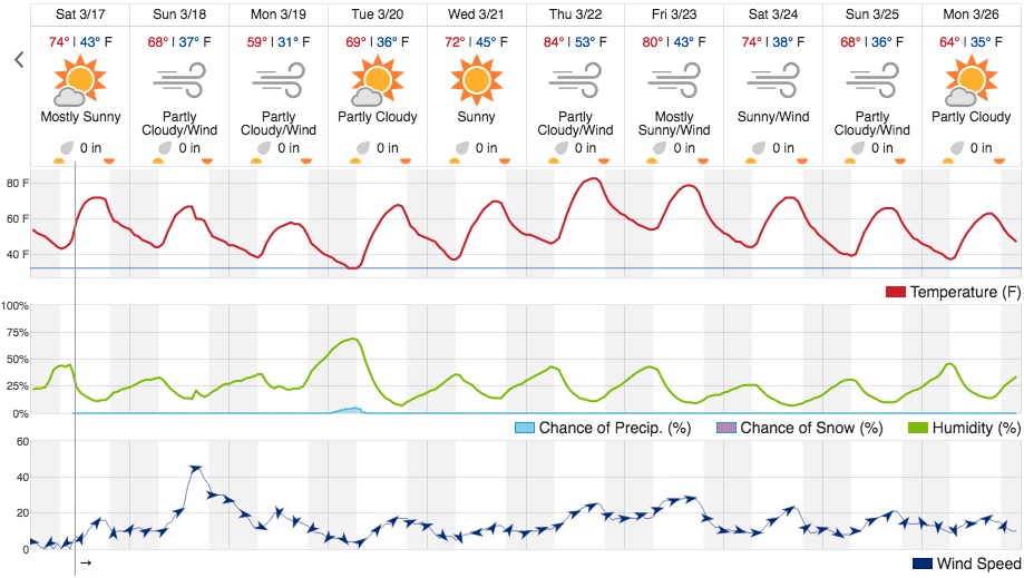
The National Weather Service chart at the top of this article shows what models predict for potential fire spread in the Tucumcari, New Mexico area, which is just outside of the Red Flag Warning for today, Saturday. It is almost a certainty that the predicted 50 mph wind gusts for Tucumcari on Sunday will generate a Red Flag Warning. Below is the Weather Underground product for the same area, which is a 4,200 feet above sea level. It shows minimum relative humidities that are in the low teens for every day through March 26 with the exception of Monday March 19 when it bottoms out at 22 percent, still quite low. Strong winds are in the forecast for Sunday, Monday, and Thursday through Sunday.

Weather forecast Tucumcari NM
Weather forecast for Tucumcari, NM. Weather Underground.