Fire On The Hills

Robinson Jeffers
Robinson Jeffers postage stamp, 1973.

In 1932 Robinson Jeffers published a book of poetry titled Thurso’s Landing and Other Poems that was set in the central coast region of California. One poem in particular was written about a vegetation fire — possibly the Matilija Fire that burned 220,000 acres that year which is the fifth largest recorded fire in the state.

The deer were bounding like blown leaves
Under the smoke in front the roaring wave of the brush-fire;
I thought of the smaller lives that were caught.
Beauty is not always lovely; the fire was beautiful, the terror
Of the deer was beautiful; and when I returned
Down the back slopes after the fire had gone by, an eagle
Was perched on the jag of a burnt pine,
Insolent and gorged, cloaked in the folded storms of his shoulders
He had come from far off for the good hunting
With fire for his beater to drive the game; the sky was merciless
Blue, and the hills merciless black,
The sombre-feathered great bird sleepily merciless between them.
I thought, painfully, but the whole mind,
The destruction that brings an eagle from heaven is better than mercy.

I have to admit — my six-second attention span rarely allows me to concentrate on the content of a poem that is more than a few lines long, but a couple of phrases stood out; Beauty is not always lovely, and in describing an eagle, Insolent and gorged, cloaked in the folded storms of his shoulders.

Mr. Jeffers led a very interesting life, coining the word inhumanism, the belief that mankind is too self-centered and too indifferent to the “astonishing beauty of things.” He briefly studied forestry at the University of Washington, had a scandalous affair with a married woman that was reported in the LA Times, and published many highly acclaimed books. But after writing about his staunch opposition to the United States’ entering World War II critics turned against him.

His work inspired photographers, as evidenced in the book by Morley Baer, Not Man Apart: Photographs of the Big Sur Coast juxtaposed with Mr. Jeffers’ poetry.

He passed away in 1962 in Carmel, California.

Thanks and a tip of the hat go out to Walt.

Goal-oriented decision-making

Goal-oriented training can change the balance between reflective and reflexive processes.

Emergency responders have all been there — they rush to get to an incident, very quickly size it up, and take action. But award-winning research looks at incident managers that include a third step, actually formulating a plan of action. It has been argued that the development of explicit plans enables shared situational awareness and goals to support a common operating picture.

An article written by Dr. Sabrina Cohen-Hatton and R.C. Honey, Goal-Oriented Training Affects Decision-Making Processes in Virtual and Simulated Fire and Rescue Environments, received the Best Paper of the Year Award from the Journal of Experimental Psychology: Applied in 2016.

The research evaluated 48 incident commanders from 11 Fire and Rescue Services in the United Kingdom who had just received one-hour of training on incident management. They were divided into two groups, one with standard training and the other that included information about decision-making:

For Group Decision, slides were included that highlighted the use decision controls, which involved using a rapid mental check list of questions at key decision points: Why am I doing this (i.e., what are my goals)? What do I expect to happen (i.e., what are the anticipated consequences)? and Are the benefits worth the risks? When participants given goal-oriented training watched the footage, and were asked what actions they would take next, they were directed to answer with reference to the decision controls.

After the brief training the firefighters participated in immersive virtual reality (VR) simulations of a house fire, a traffic collision, and a “skip fire that spreads to an adjoining shop”.

The results showed that goal-oriented training affects the decision-making process in experienced incident commanders across a variety of simulated environments
ranging from immersive VR through to live burns. There is evidence that the training can change the balance between reflective and reflexive processes which could have the potential to increase the effectiveness of communication between members of firefighting crews and to improve
safety.

Fire studies at Yosemite and Yellowstone National Parks

Above: A bison in Yellowstone National Park, May 25, 2014. Photo by Bill Gabbert.

Two recent and ongoing studies at the two big “Y” parks are yielding results about fire behavior and the effects of naturally occurring fire. The excerpts below are both from Phys.org.

The first is about allowing wildfires to burn at Yosemite National Park, rather than suppressing them:

An unprecedented 40-year experiment in a 40,000-acre valley of Yosemite National Park strongly supports the idea that managing fire, rather than suppressing it, makes wilderness areas more resilient to fire, with the added benefit of increased water availability and resistance to drought.

After a three-year, on-the-ground assessment of the park’s Illilouette Creek basin, University of California, Berkeley researchers concluded that a strategy dating to 1973 of managing wildfires with minimal suppression and almost no preemptive, so-called prescribed burns has created a landscape more resistant to catastrophic fire, with more diverse vegetation and forest structure and increased water storage, mostly in the form of meadows in areas cleared by fires.

“When fire is not suppressed, you get all these benefits: increased stream flow, increased downstream water availability, increased soil moisture, which improves habitat for the plants within the watershed. And it increases the drought resistance of the remaining trees and also increases the fire resilience because you have created these natural firebreaks,” said Gabrielle Boisramé, a graduate student in UC Berkeley’s Department of Civil and Environmental Engineering and first author of the study…

The next article covers a study into the fire behavior of this summer’s fires that spread through the footprints of the 1988 fires in Yellowstone National Park.

…”Largely up until this point, fire has not necessarily carried well through the ’88 fire scars,” Yellowstone fire ecologist Becky Smith said. “I mean, it definitely has before, but it usually takes very specific conditions, like high winds or a very specific fuel bed. But this year, we’re definitely seeing it burn much more readily in the ’88 fire scars.”

The park has called in a special federal team that studies fire behavior to find out why.

“We’re trying to use it as a good learning opportunity to try and really narrow our focus on how and when the ’88 fire scars will burn,” Smith said. The 1988 wildfires burned 36 percent of the park.

It’s the first time Yellowstone has used the special team’s services, she said.

The 13-member team is studying two fires burning in the 1988 fire scar. It has deployed special heat-resistant equipment with sensors, cameras and other instruments to measure things like temperature and wind where the fires are burning…

Depth of field effect with the new iPhone 7 Plus

In this article we completely depart from the usual theme of wildland fire and dip our toe into photography. So if you have no interest in that topic, scroll down to the next post.

When the new iPhone 7 Plus was introduced about a month ago Apple promised to add functionality to the phone’s camera in October that they called “Portrait Mode”. Yesterday the updated software, iOS 10.1, became available which enabled the feature.

This makes it possible to intentionally blur the background in a photo, leaving the foreground in focus. It changes the depth of field, that is, what is in focus. Photographers call this the “bokeh” effect and can help the viewer of the photo concentrate on the primary object without being distracted by the background. This is usually only possible with digital single lens reflex (SLR or DSLR) cameras.

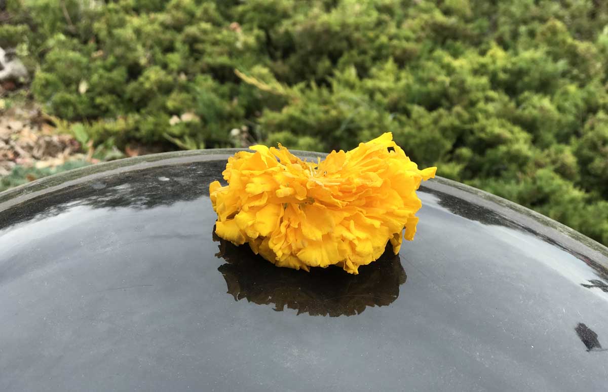
The photos below that we shot this afternoon are first, the unaltered original, followed by the Portrait Mode effect of the same photo. It’s all done just by taking one photo, but you end up with two.

flower portrait mode

flower portrait mode

Apple does this by having two cameras in the iPhone 7 Plus, each with a different lens, 28mm and 56mm. In Portrait Mode the phone compares images from the lenses, triangulating to determine the distance to various objects. Then it decides to artificially blur the ones that are farther away.

wildfire today mug portrait mode

wildfire today mug portrait mode

This feature is only available in the iPhone 7 Plus, and is not included in the smaller iPhone 7.

Want a mug similar to this?

Spread of the Junkins Fire slows

Above: Junkins Fire. Undated photo by the Incident Management Team.

The Junkins Fire has spread very little over the last two days. Most of the changes to the perimeter have been on the south side east of Highway 165, and on the northeast side south of Greenwood.

The number of personnel assigned has grown to 918. The latest size estimate is 18,132 acres. Evacuation orders are still in effect for County Road 387. Highway 165 and Custer County Road 358 are now open, however some spur roads in the fire area remain closed.

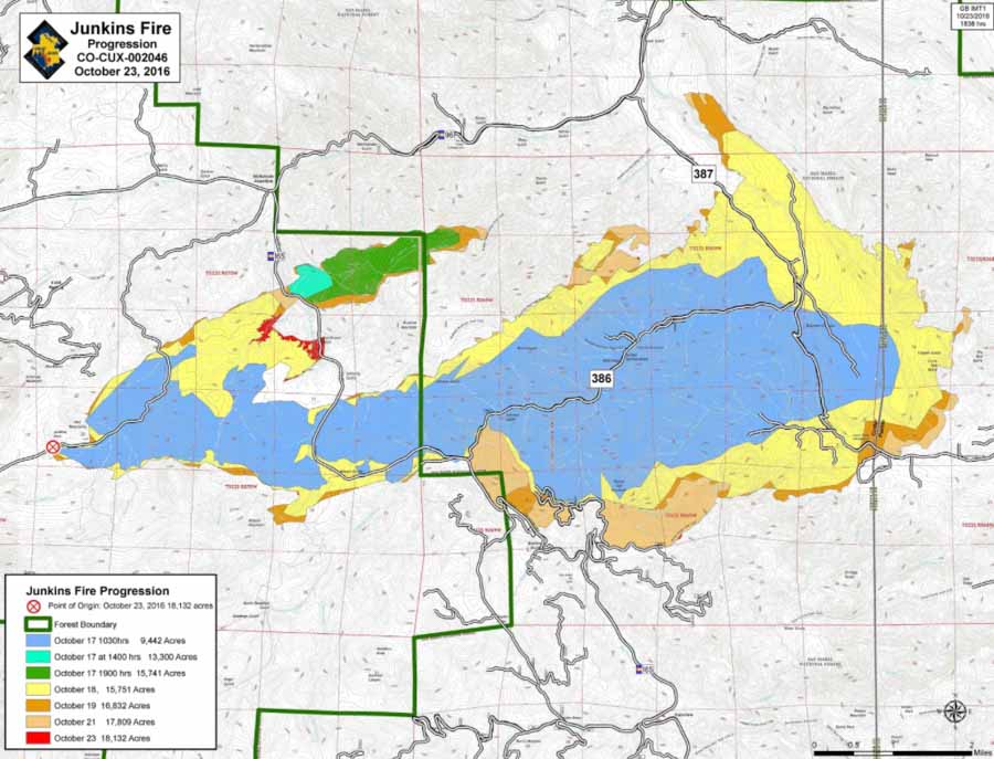
Progression Junkins Fire
Progression map of the Junkins Fire. The large blue area burned 9,442 acres on the first day, October 17. Click HERE to see a higher resolution version.

Firefighters are working on containing the northern flank, progressing east from Highway 165. Indirect dozer and hand line will be constructed along the Hardscrabble Creek drainage in preparation for planned firing operations. The northeast and eastern divisions remain in monitor and patrol status with engines continuing to secure areas around structures.

Along the southern portion of the fire, crews continue burning operations where needed, constructing direct line where possible. Multiple water sources have been established to assist as mop up operations continue.

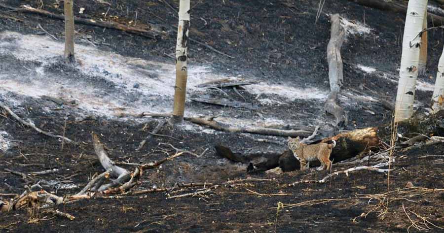
bobcat Junkins Fire
A bobcat on the Junkins Fire near Highway October 25, 2016. USFS photo by Daryl Bressan.

Articles on Wildfire Today tagged “Junkins Fire”.

Fire in Indian River County, Florida

Above: Aerial photo of the fire in Blue Cypress Conservation Area, October 24, 2016. Florida Forest Service.

(UPDATED at 1:30 p.m. EDT October 25, 2016)

The Florida Forest Service reported today that the wildfire east of Vero Beach, named the Johnny Marsh Fire, self-extinguished when the grass fire reached willow trees. The estimate of 1,000 acres will be updated after an aerial recon Tuesday afternoon.

The photo below is from Monday.

****

(Originally published at 5:14 p.m. EDT October 24, 2016)

The Florida Forest Service is responding to a wildfire in Indian River County in the Blue Cypress Conservation Area 19 miles west of Vero Beach. At 4 p.m. EDT they reported it was about 1,000 acres, and three miles long (north-south) by 1 miles wide.

The fire was reported Sunday evening and continues to grow on Monday.

map wildfire indian river county florida
Map showing heat detected at a wildfire by a satellite at 12:30 p.m. EDT October 24, 2016.
wildfire indian river county florida
Aerial photo of the fire in Blue Cypress Conservation Area, October 24, 2016. Florida Forest Service.