Loma Fire causes evacuations south of San Jose, Calif.

(UPDATED at 11:25 a.m. PDT September 29, 2016)
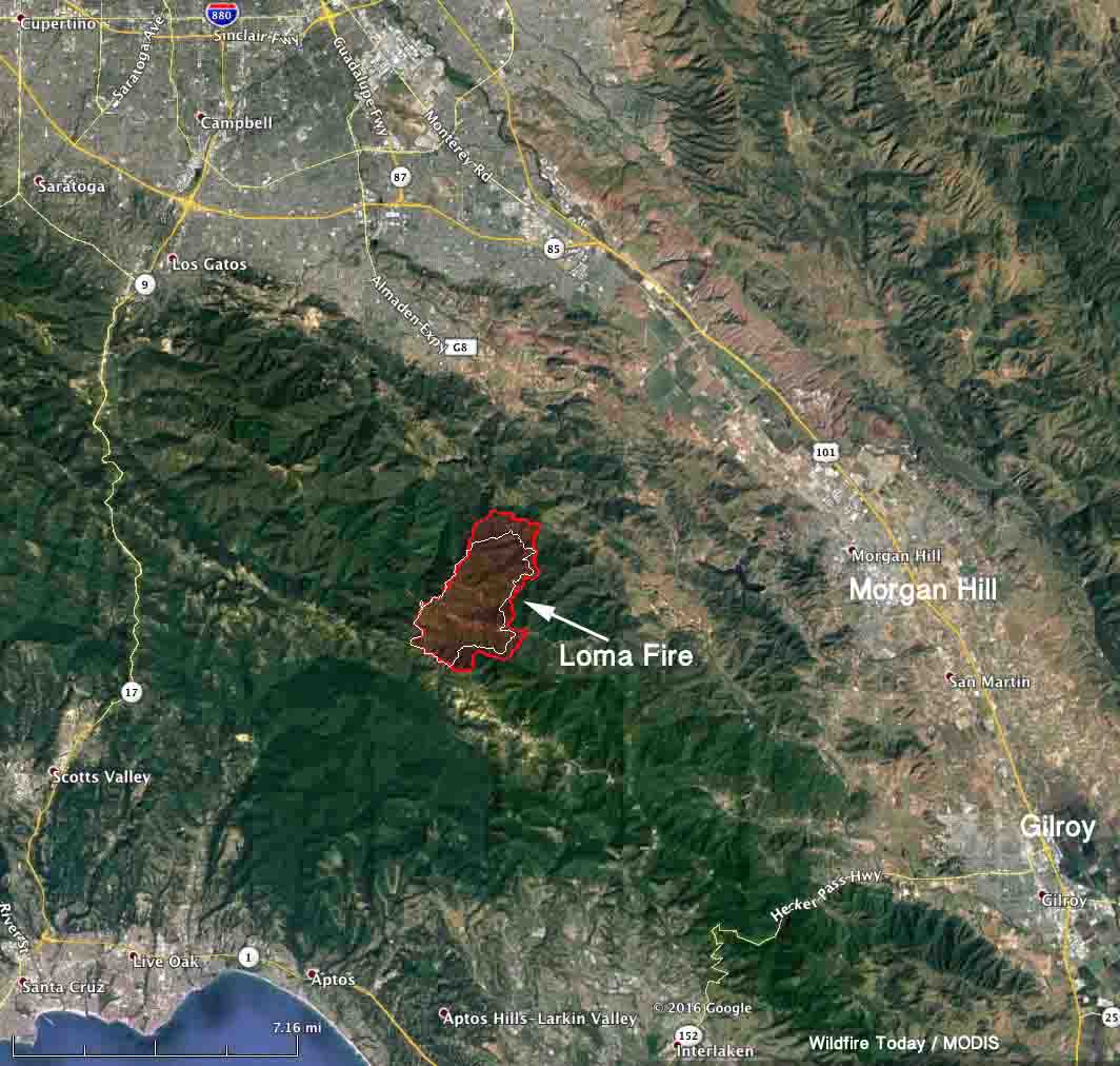
map Loma Fire
Map of the Loma Fire. The red line was the perimeter Wednesday night, Sept. 28. The white line was the perimeter about 24 hours before.

The Loma Fire south of the Silicon Valley in northern California continued to spread to the east Thursday and Thursday night, growing more than 1,000 acres to a total of approximately 4,200 acres.

****

(UPDATED at 8:12 a.m. PDT September 28, 2016)

The video below of the Loma Fire was broadcast live by UPS driver Carlos Daniel Canche on the afternoon of September 26 apparently soon after it started near Loma Chiquita Road in the Santa Cruz Mountains south of San Jose, California. There is discussion in the video’s comments about the popping noises heard in the video. According to Matt Streck with CAL FIRE, the Loma Fire began as a structure fire, so the popping could be ammunition going off as the structure burns. Other items at structure fires also make popping noises, like aerosol cans, tires, and small propane tanks without relief valves. Trees do not explode in fires.

The Loma Fire has burned about 3,100 acres as of 10 p.m. Tuesday, an increase of about 2,000 acres over the previous 24 hours. In addition to the house at which the fire originated, six outbuildings have been destroyed.

Mandatory evacuations are still in place for some areas in the Santa Cruz Mountains. The fire is burning in the Mt. Loma Prieta, Mt. Chual and Uvas Creek drainages.

Continue reading “Loma Fire causes evacuations south of San Jose, Calif.”

Water tender rolls over en route to Sawmill Fire in northern California

CAL FIRE reports there were no injuries in the rollover

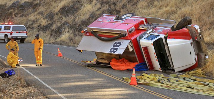
water tender rollover
A U.S. Coast Guard water tender rolled over while en route to the Sawmill Fire. Photo by Kent Porter; used with permission.

(UPDATED at 9:14 a.m. PDT September 27, 2016)

Firefighters have stopped the spread of the Sawmill Fire in northern California that burned 1,541 acres on a south facing slope along Geysers Road 26 miles north of Santa Rosa. Roads connecting geothermal facilities at the top of the ridge served as anchors for burnout operations.

3-D map Sawmill Fire
3-D map of the Sawmill Fire at 11 p.m. PDT September 26, 2016.

****

(Originally published at 8:23 a.m. PDT September 26, 2016)

A water tender rolled over while responding to the Sawmill Fire in northern California September 25. CAL FIRE reported that there were no injuries during the accident that occurred on Geysers Road in Sonoma County.

The Sawmill Fire started Sunday and by evening CAL FIRE estimated it had burned 1,500 acres. The fire is off Big Geysers Road 26 air miles north of Santa Rosa and 14 miles southwest of the community of Clear Lake. Sunday night mandatory evacuations were in place for residents in the Geysers.

DC-10 drop sawmill fire
DC-10 drops on the Sawmill Fire, September 25, 2016. Photo by Kent Porter, used with permission.

On September 21 the rollover of a water tender enroute to the Canyon Fire on Vandenberg Air Force Base in southern California resulted in the death of a firefighter.

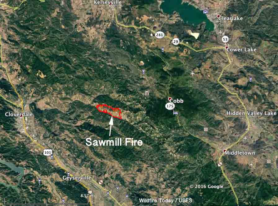
map sawmill fire
Map of the Sawmill Fire at 11 p.m. PDT September 25, 2016.

Most people do not think of the U.S. Coast Guard as having land-based firefighting apparatus, but the agency’s large training center just west of Petaluma, California has a full fire department.

Articles on Wildfire Today about the rollover of fire apparatus while assigned to a wildland fire are tagged “rollover”.

Santa Ana winds increasing in southern California

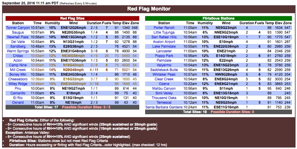
The weather station at Chilao recorded a gust of 58 mph at 10:53 a.m. PDT on Sunday.

red flag conditions

At 11:11 a.m. PDT 17 weather stations in southern California met the criteria for Red Flag Conditions. Five of them at that time had recorded gusts  of 40 and above, with Chilao having sustained winds out of the northeast at 30 mph with a gust of 58. The extreme fire weather conditions are predicted to continue on Monday, but with less severe winds.

The map below is a screen grab from an animated wind map (which is mesmerizing to watch).

wind map

Strong north or northeast winds bring Red Flag Warnings to areas in California

red-flag-warnings

Strong north or northeast winds have brought Red Flag Warnings to the Sacramento Valley and southern California. These conditions will persist into Monday in southern California, but with decreasing wind speeds.

The Red Flag map above was current as of 9:45 a.m. MDT on Sunday. Red Flag Warnings can change throughout the day as the National Weather Service offices around the country update and revise their forecasts and maps. For the most current data visit this NWS site. However, that site has not been properly displaying warning areas in recent days. This one may work better.

santa ana wind forecast

The map above illustrates conditions for Sunday, September 25.

Tribal fire chief set fires the department was paid to fight

The former chief of the Kickapoo Tribal Volunteer Fire Department in Kansas was indicted Wednesday on federal charges of setting fires the tribe was paid to fight, Acting U.S. Attorney Tom Beall said. Also indicted was a former volunteer firefighter.

Stephen D. Ramirez, 26, of Horton, Kansas, former chief, and Arlene M. Negonsott, 34, also of Horton, Kansas, are charged with four counts of wire fraud. The indictment alleges Ramirez recruited Negonsott, a volunteer firefighter, to set fires on the Kickapoo Reservation from July to November 2015 that the Kickapoo fire department was called to fight.

The Kickapoo Tribe in Kansas contracted with the Bureau of Indian Affairs to provide fire suppression services on the reservation. The contract called for the bureau to pay the tribe $600 for each fire it fought. The indictment alleges the defendants set six fires on the reservation.

If convicted, the defendants face up to 20 years in federal prison and a fine up to $250,000 on each count. The U.S. Department of Interior – Office of Inspector General, the Kickapoo Tribal Police and the FBI investigated.