Fire whirls at Burning Man

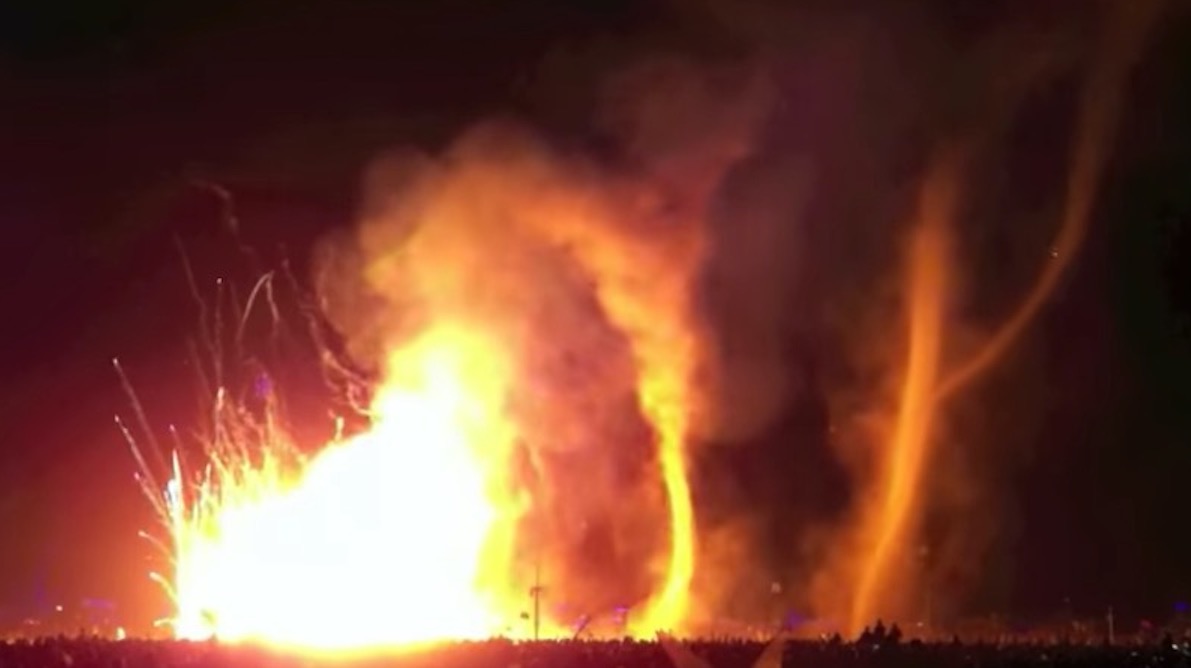
Kevin sent us a link to a very interesting video that was shot at Burning Man. It shows fire whirls and dust devils that, according to the Reno-Gazette Journal, appeared “as the Catacomb of Veils art installation [was] set on fire Friday, Sept. 2, 2016”. We can’t embed it, but you can check it out at the RGJ. The dust devils formed downwind of the intense fire, consistently and repeatedly. They form, move with the wind, dissipate, and then are replaced.

That piqued our interest so we looked around on YouTube to see if there were any more, and there’s a boat load of them. They have been occurring for years at Burning Man. Check them out HERE.

The image below is a screenshot from the video that follows it.

Burning  Man Fire Whirls
Screen shot from the video by r. E V O L U T I O N Art

Our definitive article about fire whirls, dust devils, and fire tornadoes.

Thanks and a tip of the hat go out to Kevin.

USFS Regional Fire Director describes the management of the Pioneer Fire

“There simply isn’t any safe place for [firefighters] to work”

Above:  Pioneer Fire August 31, 2016. InciWeb photo.

The Regional Director of Fire and Aviation for the U.S. Forest Service’s Northern Region, Sue Stewart, distributed a three-page document on August 31, 2016 describing the background and status of the Pioneer Fire that as of September 2 has burned 180,000 acres in central Idaho. Below are two excerpts. You can view the full document here.

****

“The Pioneer Fire on the Boise National Forest started on July 18th, and despite our best efforts it escaped our initial attack. Six weeks later, on August 31st, the fire is 157,000 acres and still spreading to the north. There is about 350 miles of fire perimeter, with 182 miles of completed fireline. Here are the things it’s important to understand about our management of this fire:

1. Our initial attack was immediate and aggressive. Here’s the narrative statement that reports our initial response on July 18th:

The Pioneer Fire was reported at 1717 hours to Boise Dispatch by the lead plane assigned to the Casner Fire while it was returning to Boise Airport. The initial fire size-up from the lead plane was 1 to 1.5 acres in continuous fuels. No structures in the immediate area of the fire and poor road access. The fire was initial attacked by one air attack, one lead plane, four helicopters, one heavy air tanker, two single engine air tankers, 11 smoke jumpers, Boise Hotshots, Crew 11, Engine 412, one wet patrol unit, and a fire investigator.

At 1804 hours dispatch received an update that the fire was increasing in size. The first resource on scene was Boise BLM Helitack at 1810 hours. They immediately ordered a heavy air tanker, two single engine air tankers, two type 2 helicopters, and one type 1 helicopter for the fire.  The helitack crew was unable to find a landing site near the fire area. They flew to Idaho City Airstrip to put on a bucket for water drops and returned to the fire.

At 1841 hours dispatch received another update that the fire was five acres, growing, burning in timber, torching, and crowning flame lengths. By 1906 hours the fire was reported between 15 and 20 acres, spotting, with uphill runs. The fire was reported to be 30 acres by air attack at 2004 hours. Later, air attack reported the fire 100 acres with group tree torching at 2127 hours.

At 2207 hours the type 3 incident commander ordered additional resources to the fire. The order included, one additional type 2 helicopter, four type 1 crews, three type 2 IA crews, five type 4 engines, two water tenders and two dozers for the next day.

The cause of the Pioneer Fire is under investigation. The origin of the fire was located on Boise National Forest in Forest Service fire protection at T7N, R6E, section 16.

Reports that heavy air tankers were sitting unordered and unused while the fire was attacked by single engine air tankers are incorrect. We only had access to one of them, the other was on a mandatory day off. (Pilots are required to stand down to rest for safety one day each week during which time critical maintenance is taken care of on those heavily used aircraft.) The initial response was commensurate with the challenges the fire presented at IA, and we launched the heavy air tanker right away.

[…]

9. If we could put this fire out without compromising the safety of our firefighters and aviators we would do so. We will not put people in harm’s way without safety zones in which they can seek refuge from extreme fire behavior, and so as the fire continues to move to the north toward the Deadwood Reservoir and into some more remote terrain our suppression investments will decline significantly commensurate with values at risk from the fire.

In the past week as the fire has moved past locations where we might reasonably and safely check its progress, we have scaled back our workforce. There are just half the numbers of firefighters as there were last week; there simply isn’t any safe place for them to work and so we are able to redirect firefighters to other incidents where they can make a difference. As the Pioneer Fire bumps into old fire scars, however, we have opportunities in the altered fuels to stop its progress and we will be taking advantage of those opportunities. A projected containment date in October is not giving up – it’s simply being realistic about what we can do safely.”
Dry thunderstorms possible in Montana and Wyoming

Friday’s weather includes Red Flag Warnings in the west and a hurricane on the east coast

Above: Weather forecast, current at 9 a.m. MDT September 2, 2016. Weatherunderground. Black text added by WildfireToday.

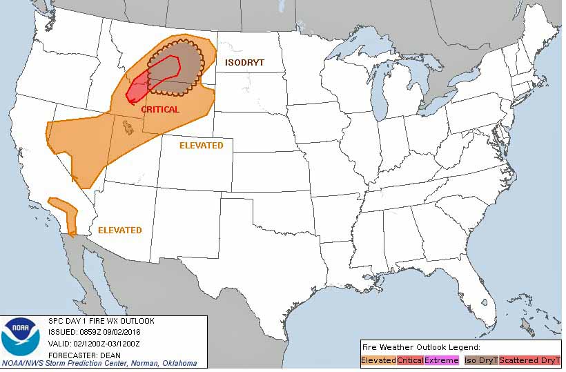
The weather map for the United States today has quite a range of conditions across the country. While Hurricane Hermine, now downgraded to a tropical storm, batters the southeast, a cold front is bringing strong winds and low humidities to some areas in the west. There is a chance of isolated dry thunderstorms in northwest Wyoming and eastern Montana.

Fire weather, September 2, 2016
Fire weather, September 2, 2016.

Wildland fire potential, September through December

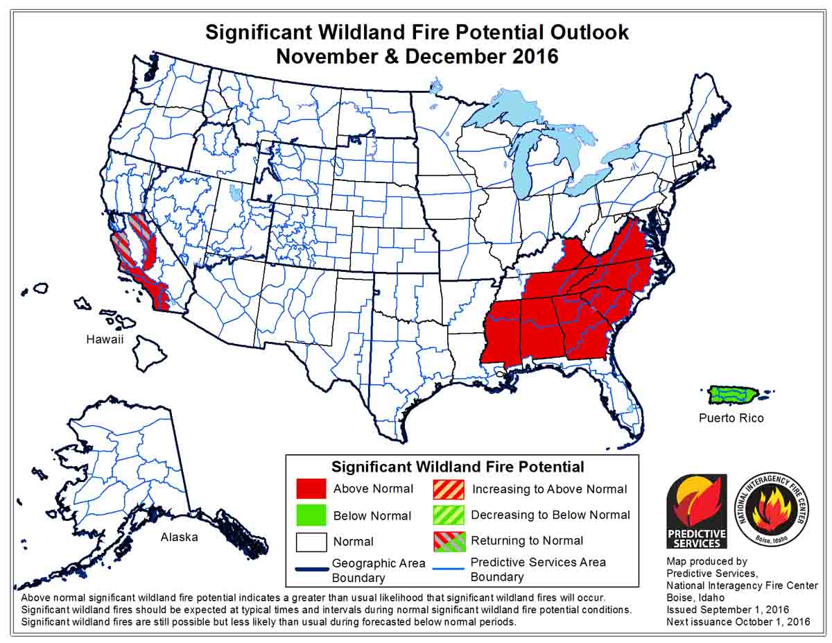
On September 1 the Predictive Services section at the National Interagency Fire Center issued their Wildland Fire Potential Outlook for September through December, 2016. The data represents the cumulative forecasts of the ten Geographic Area Predictive Services Units and the National Predictive Services Unit. Below are highlights from the outlook.

****

September is typically a month of significant change in fire conditions, especially across the northern tier of the United States. Days shorten, lessening available solar radiation to dry and heat fuels; longer nights are cooler with generally higher humidity. These conditions slowly reduce fire activity and typically end normal fire season activity throughout the month. This is expected to be the trend this season as well.

Throughout the northern portions of the Great Basin including portions of the Northwest, Northern Rockies and Rocky Mountain Areas above normal conditions will transition through the month to normal conditions and by the end of September normal conditions indicate minimal fire activity throughout this area. Occasional dry cold fronts during September and possibly October will present the potential for large fires on the landscape to grow rapidly; however, these conditions will be short in duration followed by opportunities for successful firefighting efforts. California will remain at above normal levels of fire activity throughout much of the state as dry conditions will continue and fall will bring the increased potential for offshore flow events.

wildfire potential

In October, November and December diminishing activity in the northern tier will transition to heightened activity across the southern tier; especially in central and southernCalifornia and the Southeast. California is not expected to see any significant events that will alleviate long term drought and very dry fuels. This will come with enhanced potential for offshore flow, increasing the potential for very dry and windy conditions. The southeastern United States is a significant wildcard moving into the fall months.

Tropical systems the Atlantic Ocean and Gulf of Mexico could provide substantial relief to some if not all of the area.

If this dry area remains, fall fire activity in the Southeast will be amplified and could become significant throughout the fall and winter. It is possible significant changes will occur, but the current conditions dictate elevated potential is likely.

wildfire potential

Smokejumpers used on the Holy Fire in southern California

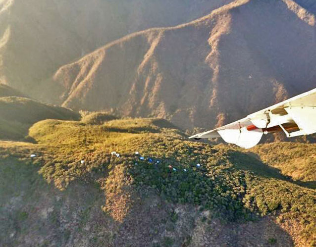
Above: Smokejumpers descend over the Holy Fire August 31, 2016. USFS photo.

(Originally published at 11:08 a.m. PDT September 1, 2016. Updated at 1:44 p.m. PDT September 1, 2016)

Until yesterday smokejumpers had never parachuted into a fire on the Cleveland National Forest. This was the only National Forest in California that had not yet inserted jumpers in this manner. Occasionally jumpers are assigned to a fire but arrive in a conventional manner, on the ground.

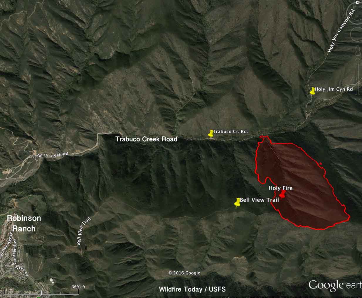
They were ordered for the Holy Fire just off of Trabuco Creek Road 2.2 miles east of the city of Robinson Ranch in Orange County, California. The fire burned 155 acres between the road and the Bell View Trail at the top of the ridge above Trabuco Canyon. The fire ran to the top of the north-facing slope and stopped thanks to the efforts of firefighters on the ground, the change in topography and fuels, and the heavy use of helicopters and air tankers, including a DC-10.

Thursday morning there were 273 personnel assigned to the Holy Fire, which got its name from the nearby Holy Jim Canyon.

Map Holy Fire
Map of the Holy Fire at 8 p.m. PDT August 31, 2016. Click to enlarge.

The Cleveland National Forest stretches between the greater Los Angeles metropolitan area and the outskirts of San Diego.

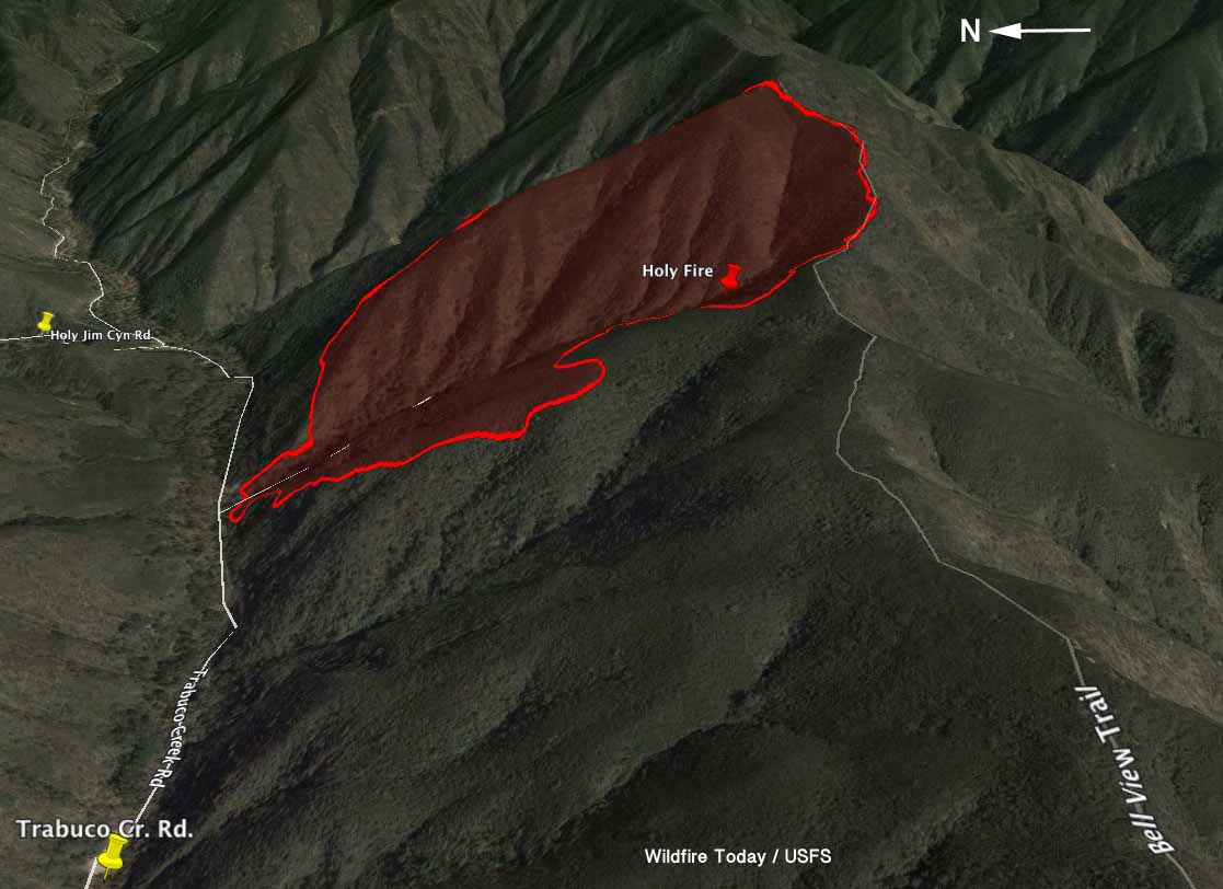
map Holy fire 3-d
3-D map of the Holy Fire at 8 p.m. PDT August 31, 2016. Click to enlarge.

Jason Foreman with the Redding Smokejumpers said the 16 jumpers were dispatched from Redding and Porterville using a U.S. Forest Service Sherpa and a contract Dornier aircraft, each with 8 firefighters. The arrival of the Dornier out of Porterville was delayed due to the very busy air space in southern California. The jumpers from Porterville landed on the ground at approximately 6:30 p.m. PDT, while the Redding squad all completed their jumps by 7:50 p.m Wednesday, Mr. Foreman said.

“A critical piece of line needed to be secured in an expeditious manner. The terrain to get to the ridgeline was steep and had limited access” Olivia Walker, spokesperson for the Cleveland National Forest said when asked why local firefighters were not used instead of the smokejumpers. “There were no personnel available to staff the section of line that was used to insert the Smokejumpers on”, she explained.

Four firefighters suffered heat-related injuries and were extracted by helicopters. The fire was managed in a unified command with the U.S. Forest Service and the Orange County Fire Authority.

Access to the base of the fire was via Trabuco Creek Road. A 3-mile hike from Robinson Ranch on the Bell Ridge Trail would take you to the top of the fire. The terrain at the fire is very steep. Hikers on the trail would have a 1,500-foot elevation change — up.

Parachute canopies Holy Fire
Parachute canopies are visible near the Bell View Trail at the Holy Fire. USFS photo.