Two wildland firefighters killed in Minnesota vehicle accident

(Originally published at 10:17 p.m. MDT August 27, 2017. Updated at 11:05 p.m. MDT August 28, 2016)

(UPDATE: the driver of the firefighters’ truck has been charged with a crime.)

Two firefighters with a Type 2 hand crew were killed in a traffic accident Saturday August 27 near Blaine, Minnesota. The Minnesota Incident Command System verified that the firefighters were part of the Beartown Fire Crew from the Keweenaw Bay Indian Community in the upper Peninsula of Michigan that was en route to the Box Canyon Fire in Utah.

The Keweenaw Bay Indian Community confirmed the tragic accident:

The Keweenaw Bay Indian Community learned this evening that our Beartown Firefighting crew was involved in a tragic traffic accident. Two of our fire fighters were killed and several others were severely injured. Our hearts are broken and our prayers are with the family members and those injured.

The seven other firefighters in the crew carrier that were injured in the crash are expected to recover.

The two deceased firefighters were identified Sunday by the Keweenaw Bay Indian Community as James F. Shelifoe, Jr., 23, of Baraga Michigan, and Alan J. Swartz, 25, of Baraga, Michigan.

The Minnesota State Patrol said in a statement:

The truck was southbound on I-35W near 95th Avenue. The truck left the roadway for an unknown reason, struck the median cable barriers, and rolled. A total of nine people were in the vehicle.

There were 11 other firefighters en route to the same fire. They were traveling in a convoy but had become separated.

According to Minnesota Department of Transportation, that section of the Interstate was closed in both directions for about four hours after the accident.

The Keweenaw Bay Indian Community in cooperation with the Bureau of Indian Affairs manages the Beartown Firefighters Type 2 hand crew. It is based out of Baraga, Michigan and is available for dispatch locally as well as nation-wide.

Our sincere condolences go out to the family, coworkers, and friends of the injured and deceased firefighters.

Thanks and a tip of the hat go out to Tom.

Red Flag Warnings August 27, 2016

wildfire Red Flag warnings

The National Weather Service has posted Red Flag Warnings for areas in Washington, Oregon, Idaho, and Wyoming.

The Red Flag map was current as of 11:14 a.m. MDT on Saturday. Red Flag Warnings can change throughout the day as the National Weather Service offices around the country update and revise their forecasts and maps. For the most current data visit this NWS site.

South entrance to Yellowstone still closed by Berry Fire

The Berry Fire in Grand Teton National Park continues to spread to the east and south.

Above: Berry fire, as seen from Leeks Marina. Undated/uncredited InciWeb photo.

The National Park Service said Saturday morning that US Highway 89 and the south entrance into Yellowstone National Park will be continue to be closed through this weekend. On Saturday even firefighter traffic was limited through the area due to fire activity and hazards from falling trees.

During the previous two days a moist air mass brought higher humidities to the fire area, and even a very small amount of rain fell in locations to the east. That changes today, Saturday, with a Red Flag Warning which covers much of Wyoming, introducing higher temperatures and lower humidities.

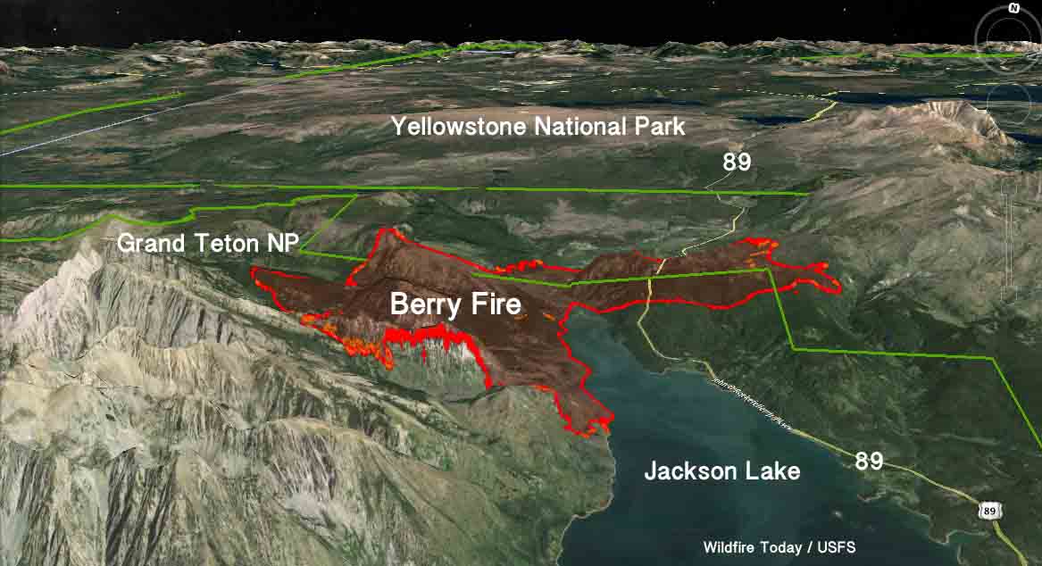
3-D map of the Berry Fire
3-D map of the Berry Fire. Data from 1 a.m. MDT August 27, 2016. Click to enlarge.

Since Tuesday the fire has grown along most of the perimeter, especially on the north, east, and south sides, and now covers 12,378 acres according to the NPS. From east to west it is 7 miles wide and it stretches for almost 4 miles along the west shore of Jackson Lake.

The National Park Service is not aggressively suppressing the fire, but is managing it for ecological benefits.

Resources assigned to the Berry Fire include 351 personnel, 6 hand crews, 18 engines, and 5 helicopters.

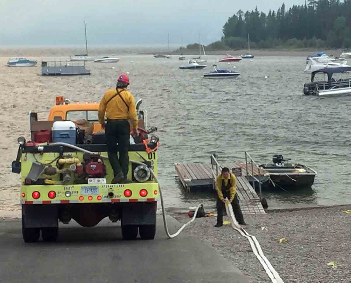
Berry Fire
Filling an engine from a lake on the Berry Fire. Undated/uncredited InciWeb photo.

Both Yellowstone and Grand Teton National Parks are open for visitors, but anyone planning to enter Yellowstone from the south on US Highway 89 will have to take a very lengthy detour. All other entrances into Yellowstone are open, as are all of the roads in that park.

Yellowstone’s 30,309-acre Maple Fire a few miles east of West Yellowstone, Montana, has not crossed US Highway 20, also known as the West Entrance Road. There are at least two other significant fires in Yellowstone, the 3,024-acre Buffalo Fire near the north boundary, and the 1,922-acre Fawn Fire in the northwest corner. These fires are not impacting visitors except for the smoke being created that degrades visibility of the beautiful landscape.

map Fires in Yellowstone and Grand Teton National Parks
Fires in Yellowstone and Grand Teton National Parks, August. 27, 2016. Click to enlarge.

Our other articles on these fires in Yellowstone and Grand Teton National Parks.

Colorado fire chiefs’ recommendations for improving wildfire response

Each year since 2013 the Colorado Legislature has created interim Wildfire Matters Review Committees, with the apparent primary purpose of proposing bills relating to wildfire. And every year the Colorado State Fire Chiefs Association (CSFC) submits to the committee a broad range of recommendations for improving the state’s ability to mitigate and respond to wildfires.

This year is no exception. On August 15, CSFC Executive Director Garry Briese testified before the 2016 committee, providing the association’s view of the progress that has been made, the work underway, and the work that remains to be done on seven priorities that the CSFC first identified in 2013.

The written version of the testimony is an interesting look at how the association’s recommendations have evolved since 2013. For each of the seven priorities an update was added every year showing the history of the progress made, or not made, in each category.

Their seven recommendations, with the three highest priorities at the top, are:

  1. Ensure the stability and reliability of the current Colorado statewide emergency radio system;
  2. Continue to invest in the development, expansion and implementation of the State resource mobilization plan;
  3. Expand the current local, regional and state command, control, and coordination capabilities;
  4. Provide sufficient funding to the Division of Fire Prevention and Control (DFPC) to fulfill its stated missions;
  5. State aviation resources are an essential and integral part of the initial attack on WUI fires; 
  6. Develop measurable and clearly articulated performance goals for response to WUI fires to guide the response of local, mutual aid and State resources; and,
  7. Recognize that while community and individual homeowner mitigation is an essential component of a comprehensive WUI strategy, it is not an effective immediate or mid-term solution to our State’s immediate threats.

The report identifies progress in mobilization, and called as success stories the multi-mission aircraft, the Colorado Wildfire Information Management System (CO-WIMS), and the Colorado Center of Excellence for Advanced Technology Aerial Firefighting. But much remains to be done, the CSFC report said, in communications, homeowner hazard mitigation, and support for incident management teams.

You can read the entire document here.

Thanks and a tip of the hat go out to Bean.

Updates on three California fires, Soberanes, Chimney, and Rey

Above: A firing operation on the Soberanes Fire by the Arroyo Grande Hotshots. Inciweb photo.

Soberanes Fire

This fire has been eating through the brush, grass, timber, and poison oak in the coastal mountains south of Monterey since July 22. In that time it has spread mostly to the south blackening over 91,000 acres.

Map Soberanes Fire
Map of the Soberanes Fire. The red line was the perimeter at 11 p.m. PDT Aug. 25. The white line was the perimeter at 1 a.m. PDT Aug. 7. Click to enlarge.

The only large heat sources a satellite 200 miles overhead was able to detect in the last 24 hours were near the perimeter on the south and southeast sides. The Soberanes Fire is being fought by 1,4913 personnel including 21 hand crews; 65 engines; 12 helicopters; 21 dozers; and 14 water tenders.

The fire was caused by an illegal, unattended campfire on the Soberanes Canyon trail in the Garrapata State Park. The suppression costs to date are $160 million.

Poison oak is very prevalent in the area and some firefighters are saying it is the worst they have even seen. Five hundred have reported to the fire’s medical units for poison oak related ailments, with 200 cases in the past three days.

Rey Fire

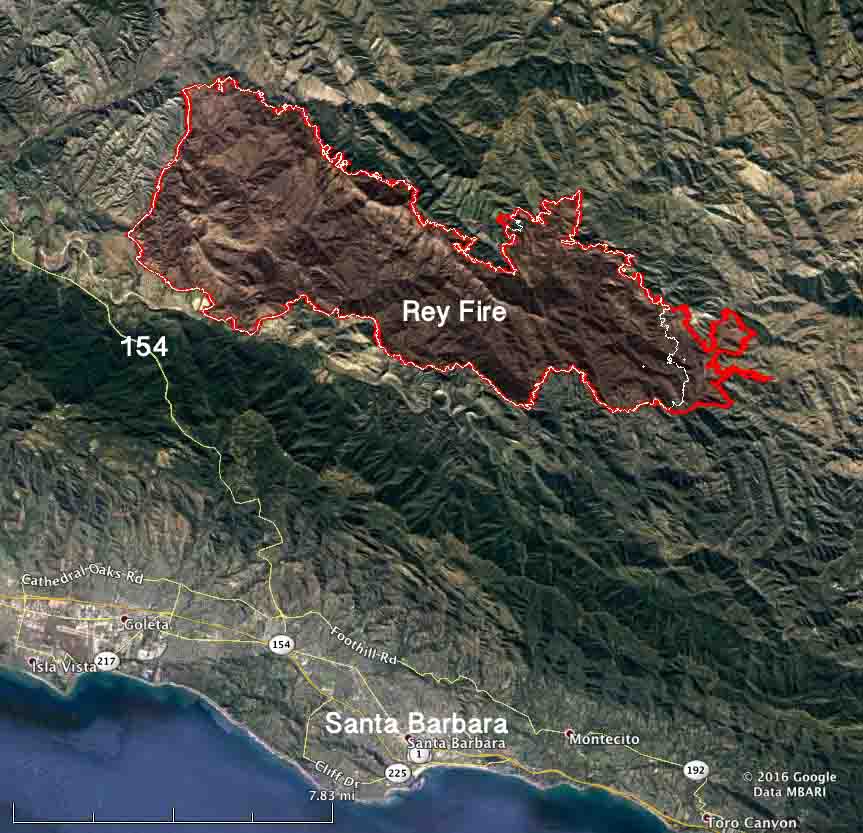
The Rey Fire north of Santa Barbara has been working its way east over the last several days but that growth has slowed as firefighters make progress by constructing direct firelines on the fire’s edge and completing contingency lines out ahead of the fire.

Map Rey Fire
Map of the Rey Fire. The red line was the perimeter at 10 p.m. PDT Aug. 25. The white line was the perimeter at 10 p.m. PDT Aug. 23. Click to enlarge.

The Rey Fire typically slows to a crawl late at night when the marine layer moves in, then the activity increases in the afternoon. The incident management team is calling it 33,006 acres. Approximately 1,976 personnel are assigned to the fire, including 57 hand crews, 99 engines, and 18 helicopters.

Chimney Fire

The Chimney Fire near the central California coast has continued to spread to the north over the last few days through very rough and remote country east of the Hearst Castle.

Map Chimney Fire
Map of the Chimney Fire. The red line was the perimeter at 9 p.m. PDT Aug. 25. The white line was the perimeter at 10 p.m. PDT Aug. 23. Click to enlarge.

CAL FIRE reports that 49 residences and 21 other structures have been destroyed, while 1,898 remain threatened. Some evacuation orders have been lifted but others are still in place.

The 45,000-acre Chimney Fire is being fought by 4,028 personnel, including 328 engines, 106 hand crews, 16 helicopters, 46 dozers, and 69 water tenders.

Fire whirl spreads fire near Valleyford, Washington

Spokane, North Idaho News & Weather KHQ.com

This video shot by Big Rock Farms in Valleyford, Washington at the Yale Road Fire is an example of how a large fire whirl can very quickly spread a fire in flashy fuels.

KHQ.com described the action (you might hear a four-letter word or two):

Jay Cronk is driving a tractor through a field, attempting to lay a fire line with flames just feet away, when suddenly, the fire takes over, forcing Cronk to race away before the fire reaches the combine and the fuel tank.

Melanie Steele, Brandon Cronk and Dean Walker are the ones you hear behind the camera shouting, “Pull away! Pull away!” as they sit anxiously in another vehicle on a nearby road.

Someone also says:

You see why you don’t want to get in front of that?

The Yale Road Fire 12 miles south of Spokane forced dozens of residents to evacuate and destroyed 10 homes. As of August 25 it had burned approximately 5,791 acres. Along with the 341-acre Wellesley Fire it was part of the Spokane Complex.

We wrote more about fire whirls and fire tornadoes on August 14.