The Terrace Fire is near Monte Rio, northwest of Santa Rosa
10:31 a.m. PST Feb. 11, 2022
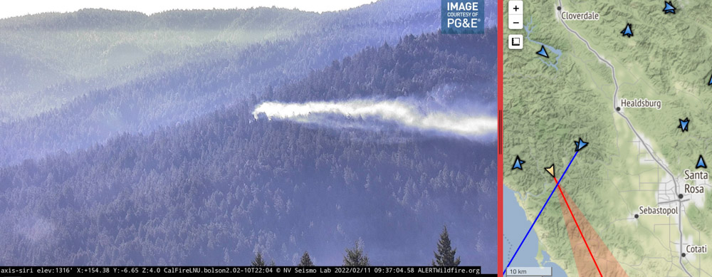
Using its spotlight, Sonoma County Sheriff’s Office helicopter Henry 1 directs firefighters to a fire near Monte Rio in Northern California. As seen from the Alert Wildfire camera at Siri, in infrared mode at 10:32 p.m PT Feb. 10, 2022.
Firefighters in Northern California had assistance from a Sonoma County Sheriff’s helicopter Thursday night as they were finding the best route to hike to the Terrace Fire near Monte Rio. It was reported at about 9 p.m. on a slope above Highway 116. The helicopter known as Henry 1 used its spotlight to direct the personnel as they hiked through the densely forested area.
When crews reached the blaze at about 11 p.m. they reported it had burned about one acre. Friday morning the Alert Wildfire camera at Siri showed that it is still generating a fair amount of smoke which is being blown close to the ground by the wind.
Image of smoke from a fire in Sonoma County near Monte Rio as seen from the Alert Wildfire camera at Siri, 9:37 a.m. PT Feb. 11, 2022. The intersection of the lines from the two camera locations indicate the approximate location of the fire.
The fire is about 14 miles west-northwest of Santa Rosa.
The Press Democrat reported Friday morning that Stephane Lunsford, a public information officer for CAL FIRE, said crews had completed a line around 85 percent of the fire.
Kent Porter (@kentphotos) shot some very interesting photos Thursday night. Here are a couple. Click on them twice to see larger versions:
Extremely tough access for fire crews Thurs. in a heavily forested area of Monte Rio, so @sonomasheriff Henry 1 illuminated the way for firefighters (it’s a walk in show to put the fire out). This is one of those times I backed off and looked for the artsy moment. @NorthBayNewspic.twitter.com/zjLYcZUYuG
A one-acre fire is not huge news. We don’t often hear about fires like this. But it’s an example of how firefighters are usually successful in keeping fires small, even when it requires hiking for hours at night through dense woods to find and then put out a fire.
In addition, it’s a fire in early February, far outside the traditional fire season in Northern California. But also the images are fascinating — the infrared photo showing the spotlight from the helicopter, smoke from the fire the next morning, and especially the great photos taken by Mr. Porter.
Hundreds of residents were evacuated before dawn Thursday
Updated at 10:08 p.m. PT Feb. 10, 2022
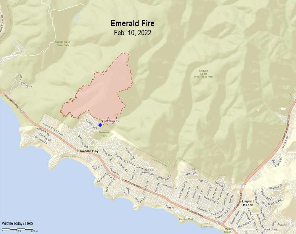
Map Emerald Fire, Feb. 10, 2022.
Thursday morning firefighters stopped the spread of the 145-acre Emerald Fire northwest of Laguna Beach in Southern California. At the peak of activity there were 220 personnel assigned, plus numerous helicopters and fixed wing aircraft.
All of the evacuation orders were lifted at 3 p.m. and no structures were destroyed. Areas in the interior of the fire are still burning, fire officials said Thursday afternoon, and the predicted hot, dry weather means they will have to continue to monitor, mop up, and improve containment.
The last time the area burned was during the Laguna Fire of 1993 which covered 14,337 acres, enveloping almost the entirety of Crystal Cove State Park and Laguna Coast Wilderness Area.
A spokesperson for the fire said good clearance of vegetation around the homes made it much easier for firefighters to prevent any structures from burning.
Fire personnel will be on scene Thursday night and fresh troops will arrive Friday morning.
1:04 p.m. PT Feb. 10, 2022
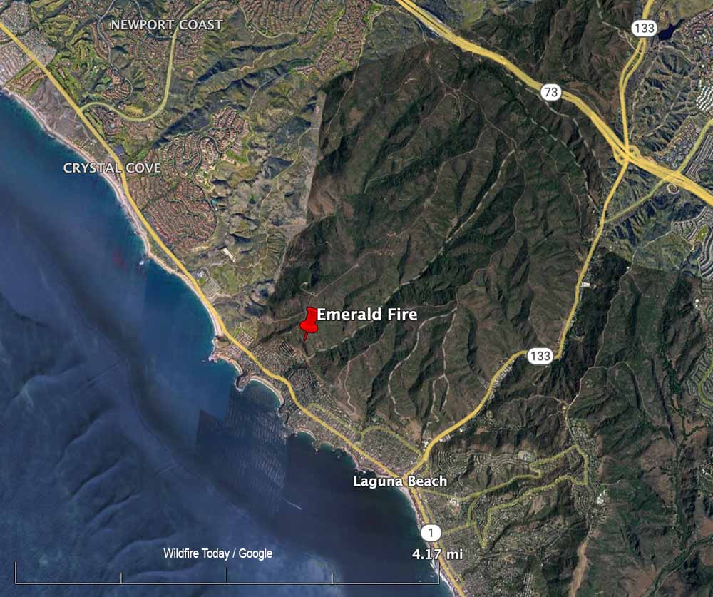
Map showing the location of the Emerald Fire near Laguna Beach in Southern California, Feb. 10, 2022.
Evacuation orders for the Emerald Fire prompted hundreds of residents in Laguna Beach in Orange County, California to leave their homes before dawn Thursday. Reported at about 4 a.m. in the Laguna Coast Wilderness Area, strong winds pushed the blaze near homes in the Emerald Bay in the coastal city.
As the fire was spreading, a weather station at Moro Canyon recorded 15 to 22 mph winds gusting out of the north-northeast up to 43 mph while the relative humidity was 31 percent. Those conditions are conducive to rapid fire spread and would have pushed the fire to the south-southwest. When the winds subsided later in the morning firefighters were able to stop the spread. Preliminary estimates put the size at about 140 acres, but that could change with more accurate mapping.
“We no longer have a fire season. We have a fire year,” said Orange County Fire Authority Chief Brian Fennessy in a news conference Thursday morning. “It’s February 10. This is supposed to be the middle of winter and we’re anticipating 80 to 90 degree weather. Even though the hillsides are green it doesn’t take but low humidity and wind to cause fires to occur. If this is any sign of what’s to come throughout the rest of the winter and spring we’re in for a long year.”
Two weather advisories are in effect for much of Southern California on Thursday, including the Emerald Fire area; one is for wind and another for heat. The forecast for the Laguna Beach area for Thursday morning called for northeast winds of 15 to 25 mph with gusts to 45. The heat advisory predicted high afternoon temperatures of 91 degrees.
The Hutchinson Fire Department said in a news release Wednesday morning that the fire east of the city, now named the Albright Fire, was about 90 percent contained.
Pushed by strong winds, the fire which started south of Buhler ran south for about two miles from 30th Avenue to 4th Avenue. Firefighters worked Tuesday night and by morning all roads had reopened but burnout operations may cause temporary closures of some streets.
Fire Marshal Michael Cain has been investigating the fire to determine the cause, which is still believed to be embers from some of the 75 brush piles that were ignited on private land last Thursday when snow was on the ground. Warmer weather melted the snow rapidly and at least one of the piles spread Tuesday during the strong winds as the humidity dropped to 13 percent.
Damages to property and the total number of acres burned was still being determined Wednesday morning.
Updated at 12:37 a.m. CST Feb. 9, 2022
The winds that had been gusting at more than 30 mph slowed after 6 p.m. on Tuesday making it much easier for firefighters to begin to get a handle on a large wildfire a few miles east of Hutchinson, Kansas. Combined with relative humidity that dipped as low as 13 percent the strong winds resulted in the fire spreading south for nearly two miles from where it started just south of 30th Avenue near Buhler Road.
From the Hutchnews:
“By the time we got there, it was already running north to south,” Fire Chief Steve Beer said. “Numerous departments were called in to help with structure protection. We started an early evacuation of two or three dozen homes. We got everyone safely evacuated who wanted to leave.”
The evacuation was primarily in homes along Fourth Avenue, Beer said. It wasn’t a mandatory evacuation, so not everyone left.
“The fire didn’t move that fast,” Beer said. “But when it got in the cedars it would throw flames 50 feet into the air. It’s pretty impressive to watch. We’re thankful, it was not as bad as it could have been. The key to this area is to do back-burns. Once we did get ahead of it with enough resources, we got a handle on it.”
Fire officials said the likely cause was embers from woodpiles that were burned over the weekend.
As the weather conditions moderated, by 7 p.m. Tuesday some firefighting resources were being released and residents were expected to be back in their homes later in the evening.
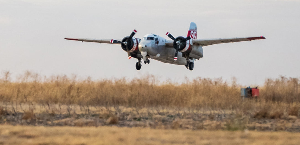
Chief Beer said the S-2 air tanker aided firefighters by attacking the blaze in areas that were difficult for them to access due to sandy soils and cedar trees.
Originally published at 5:44 p.m. CST Feb. 8, 2022
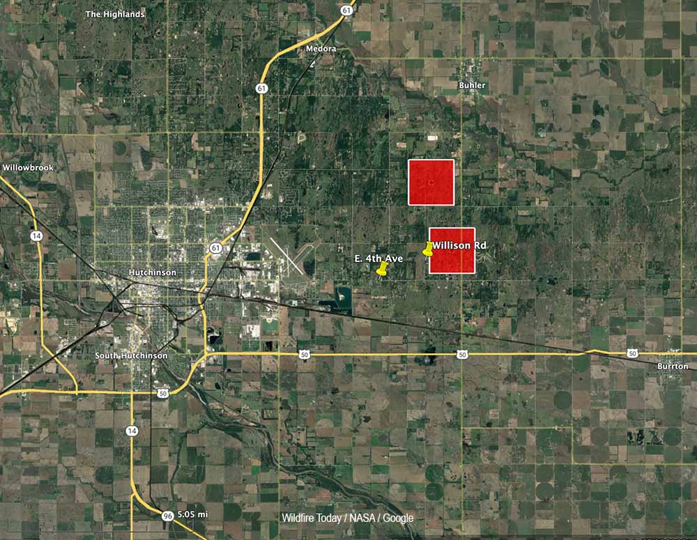
The map shows red squares that represent the approximate locations of heat at a fire detected east of Hutchinson, Kansas by the GOES-16 satellite at 2:40 p.m. CT Feb. 8, 2022.
Firefighters are working to contain a large wildfire about three miles east of Hutchinson, Kansas. Strong winds out of the north gusting to 36 mph are pushing the blaze to the south.
Crews are working to save structures near the intersection of East 4th Avenue and Williston Road.
The area is under a Red Flag Warning for high fire danger due to the powerful winds. The relative humidity was measured at 13 percent in Hutchinson at 4:52 p.m. The National Weather Service expects the wind speeds to decrease after sundown.
The fire is approximately three miles east of Hutchinson, about 2 miles south of Buhler, and 32 air miles northwest of Wichita.
Air tanker 95, a privately owned S-2, was dispatched to the fire. It is operated by Ag Air Service out of Nikerson, Kansas.
Air Tanker 95, an S-2. Kansas Forest Service photo.
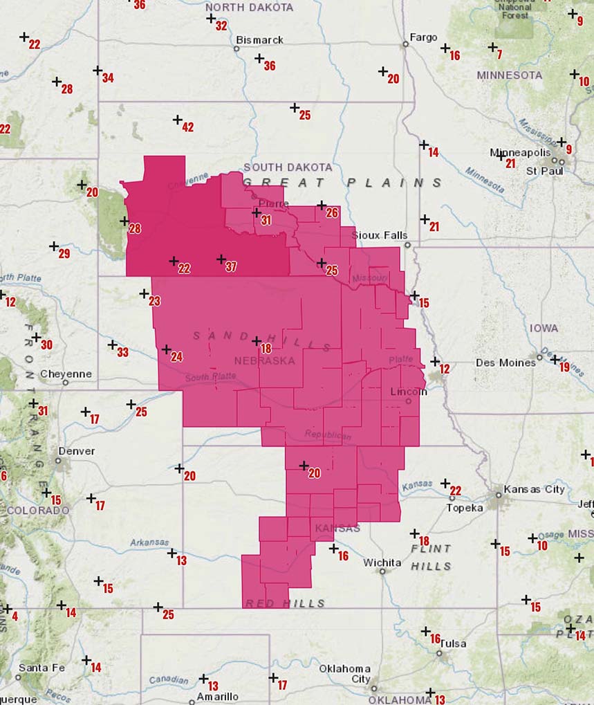
Red Flag warnings, Central Plains. Map shows wind gusts at 10:45 a.m. CST Feb. 8, 2022. NWS.
A Red Flag Warning is in effect February 8 for low humidity and strong winds in parts of the Central Plains Tuesday, affecting areas in South Dakota, Nebraska, and Kansas. The warnings expire around sunset.
The forecast from the National Weather Service calls for increasing winds in the morning, tapering off in the late afternoon:
South Dakota: 20 to 25 percent RH with 20 to 45 mph winds gusting at 50 to 65 mph.
Nebraska: 15 to 25 percent RH with 20 to 30 mph winds gusting to 45 mph.
Kansas: 17 percent RH with 20 to 25 mph winds gusting to 40 mph.
Smoke column from the Williams Fork Fire southwest of Fraser, Colorado, Aug. 15, 2020. USFS photo by Lauren Demos.
The Guardian has an excellent long-form article about wildland fires, titled ‘A deranged pyroscape’: how fires across the world have grown weirder. Author Daniel Immerwahr writes that in banishing fire from sight, we have made its dangers stranger and less predictable. He writes about fires around the world, pyrophobia, indigenous fire, and how hundreds of thousands die each year from such smoke-related maladies as strokes, heart failure and asthma.
Toward the end of the article he writes about fires in Indonesia where forests have been drained, burned, or clear cut, then summarizes.
Here is an excerpt:
…No single one of Indonesia’s many fires in recent decades has been especially noteworthy. But altogether they’ve been cataclysmic. In 1997, a dense haze of airborne particulates from Indonesia’s fires was perceptible as far as the Philippines and Thailand. That year, on Sumatra – centre of Indonesia’s fires – a commercial plane crashed due to poor visibility and killed all 234 aboard. The next day, two ships collided off the coast of Malaysia for the same reason, and 29 crew members died.
The economist Maria Lo Bue found that Indonesians who were toddlers during the 1997 haze grew less tall, entered school six months later and completed almost a year less of education than their peers. Another economist, Seema Jayachandran, found that the fires “led to over 15,600 child, infant and fetal deaths”, hitting the poor especially hard.
Picture a dangerous fire and you’re likely to imagine a thicket of tall trees blazing in a drought-stricken climate. But a more accurate image is smoldering peat or scrub burning by a tropical logging road. The real threat isn’t catching fire, but the slow violence of breathing bad air. You’ve got a hacking cough, your father suffers a stroke and you watch your daughter – short for her age – leave school a year early.
—
Fire is not in itself a bad thing. Many landscapes, built to burn, simply couldn’t exist without regular fires, either natural or intentional. Though foresters once sought to tamp blazes out everywhere, we now recognise that as a grave mistake. A fireproof planet isn’t something we can get, or should even want.
We badly need a healthier relationship to combustion. Rather than erratic, runaway fires, we need regular, restorative ones, like we used to have. Our forebears didn’t shun flame – they were relentless fire-setters. But they adhered to two important limits. First, they fed their fires with living vegetation, which reclaims lost carbon as it regrows. Second, they were guided by long-acquired experience with fire’s complex paths and consequences.
We’ve blasted far past both of those limits. We’re now burning fossilized vegetation, which sends carbon on a one-way trip to the warming atmosphere. And we’re kindling fires that bear little resemblance to the ones we’re used to. There’s no generational wisdom telling us what to do when we drain the peatlands of Central Kalimantan or let dry fuel pile up precariously in the California countryside, all while raising the temperature to hitherto unrecorded heights.
Booksaboutfire typically end with prescriptions: we must invest in science, reclaim lost cultural knowledge, burn intentionally, build resiliently, and power our grids renewably. All that is true, surely. But given how complex fire is, and how unprecedented nearly everything we’re doing with it is, the best advice would seem to be: slow down. We have scrambled our landscape, changed our energy diet, altered the climate and revised our relationship to flame, all in a very short time. It’s not a surprise that fire, once a useful if obstinate companion to our species, has now slipped our grasp.
The world won’t burn up, as we sometimes imagine. But the fires of tomorrow will be different from those of yesterday, and we’re racing headlong into that unsettling future, burning tankfuls of gas as we go.
A wildland firefighter will be competing in the Winter Olympics in China. Robby Burns grew up near Mount Shasta, California and has been a professional snowboarder for the last five years. He was a lead firefighter on the Shasta Lake Interagency Hotshots from 2013 to 2015. This past summer, he worked on an engine crew assigned to the Dixie Fire, Salmon River Complex, Corral Complex, Forks Complex, Mad River Complex, and Gasquet Complex. According to the US Forest Service, Mr. Burns recently accepted a position on the Shasta Lake Interagency Hotshot Crew.
“Robby was an integral part of the success of the crew,” said Joe Bogdan, Shasta Lake IHC superintendent. “We deeply respect the sacrifices he has made and his discipline to achieve his goals. We created lifelong and battled-tested relationships through our time working together.”
On his website he describes himself as “snowboarder, firefighter, speaker.”
The 31-year old will be competing in the Parallel Giant Slalom event February 7th PT. Qualifications begin at 7 p.m. PT with the subsequent races continuing through the night, U.S. time. (Update Monday Feb, 7: NBC is showing the event starts Monday at 9:40 p.m. ET, 6:40 p.m. PT. Times are subject to change due to weather and other factors.)
When he leaves the starting gate in Beijing, he will be wearing his Shasta Lake IHC buckle, which he earned after completing his third season on the crew.
In January of 2020 Mr. Burns finished first in the Nor-Am Cup Parallel Giant Slalom race in Steamboat Springs, Colorado.
In November he sustained a leg injury after falling when he was training in Northern Canada. It put him on crutches and resulted in him missing the first stop of the World Cup tour in Russia.
On November 30, 2021 he wrote on his Facebook page, “Yesterday I made it from two crutches to one! Feels like I just graduated kindergarten! While it was a scary injury to my knee, the pictures say all the real important stuff still works good. With 2 weeks of intense PT the doc says he thinks I’ll be right as rain. So, while the “ship” isn’t moving at full speed, I’ll be moving full speed at this snail pace for a little while. But I’m in the best place to do this work. And sometimes life has a way of telling us to slow down.”
About 16 days after writing he was on one crutch, he competed in a World Cup snowboarding event in Carezza, Italy finishing 42nd of the 70 who qualified. Mr. Burns appeared in two more races in Europe in January finishing 43rd and 53rd. Currently he is ranked 30th in the FIS Snowboard Points List.
Robby Burns, photo, posted Jan. 21, 2022.Robby Burns at the Olympics Opening Ceremonies. Robby Burns photo, posted Feb. 4, 2022.
In 2014 another member of the Shasta Lake Hotshots was mentioned on the pages of Wildfire Today when Steven Woodlief bought a $2 ticket in the California state lottery and won $1.3 million, $1,000 a week for life. At the time Mr. Woodlief said he would buy a new truck.
Thanks and a tip of the hat go out to Jim and Kevin.