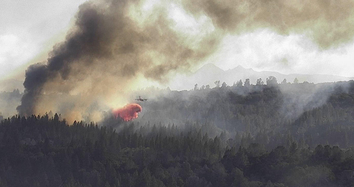
The Jimmy’s Waterhole Fire in New Jersey was declared 100% contained on Thursday by the New Jersey Department of Forestry, having burned some 3900 acres, nearly half the state’s annual average in two days.
WILDFIRE UPDATE: Manchester Township – Jimmy’s Waterhole Fire
At 10 a.m. Thursday, April 13, the New Jersey Forest Fire Service has achieved 100 percent containment of a 3,859-acre wildfire in Manchester Township on federal, state and private property. pic.twitter.com/0KWhGZTaMU
— New Jersey Forest Fire Service (@njdepforestfire) April 13, 2023
This and other regional fires prompts a visit to the Eastern Area Fire Environment Outlook to explore the conditions that led to the late April fire bust. On Friday’s Morning Briefing, the Eastern Area Coordination Center had nearly 40 percent of reporting units in Very High to Extreme Fire Danger, with the largest fires in New Jersey, Missouri, Pennsylvania, Michigan and Rhode Island. In the past week, the region recorded 349 fires for 12,600 acres.
While spring is often active in the east — as forest fuels dry out between winter snow and rains and prior to green up — the last week was drier throughout the Northeast and Midwest, as well as in the Great Plains and Southwest. Look south and you can spot the focused and incredible “purple” deluge in Fort Lauderdale, Florida, and to the north there’s an unusual heart-shaped moisture pattern in Michigan.
7-Day Percent of Normal Precipitation through April 14, 2023.
Fire activity in the region has been moving northeast toward Maine with the bubble of heat, including a fire point seemingly in the Atlantic — though a closer look at the Fire Weather Dashboard (with fire points activated) places the the fire on Martha’s Vineyard.
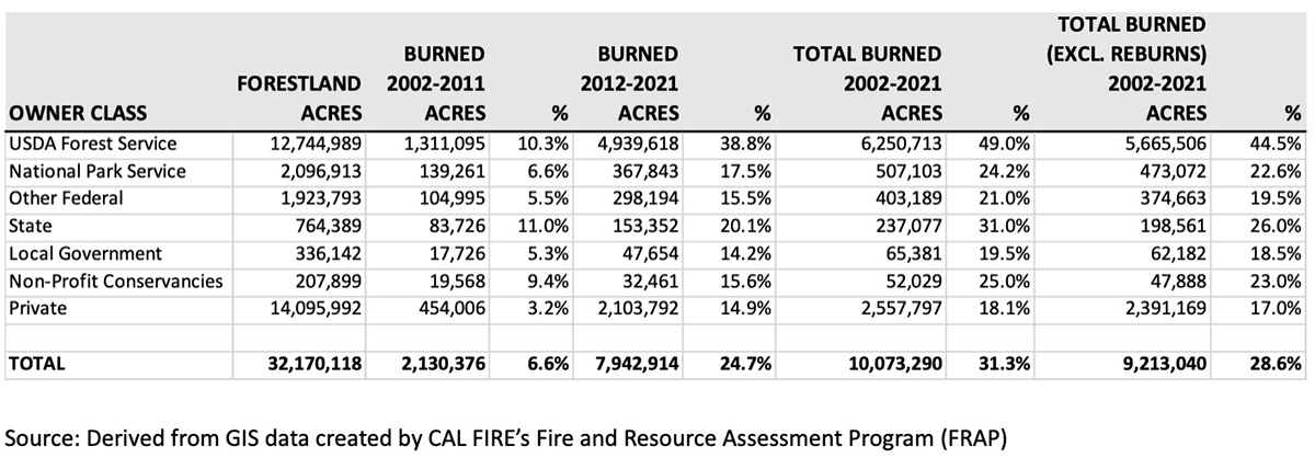
About 25 percent of the states’ forestland burned in the last 10 years — more than triple the previous decade
BAe-146 drops on the Winding Fire in Northern California June 18, 2022. InciWeb.
By Jim Schmidt
Of the 32.1 million acres of forestland in California, approximately 2.1 million acres (6.6%) burned in wildfires in the 2002-2011 time period. In the following decade (2012-2021), that figure more than tripled to 7.9 million acres (24.7%).
National Forests in California were particularly hard hit. 10.1% of 12.7 million acres of forestland managed by the USDA Forest Service in California burned in 2002 – 2011 time period. In the 2012 – 2021 decade that figure increased to 38.8%. Excluding areas that re-burned in the last 10 years, 44.5% of the forestland in California National Forests has burned in the last 20 years. In contrast, only 22.6% of National Park forestland in the state has burned in the same time period. About 14 million acres of forestland in California are in private hands. 17.0 % of private forestland has burned since 2001.
Forestland acres burned by wildfires in California by owner class, 2002 – 2021. Jim Schmidt
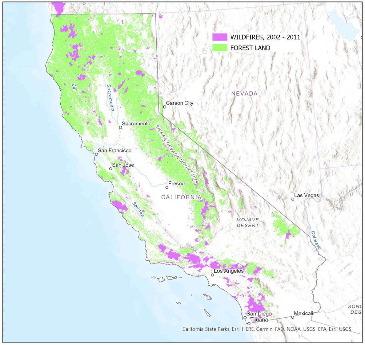
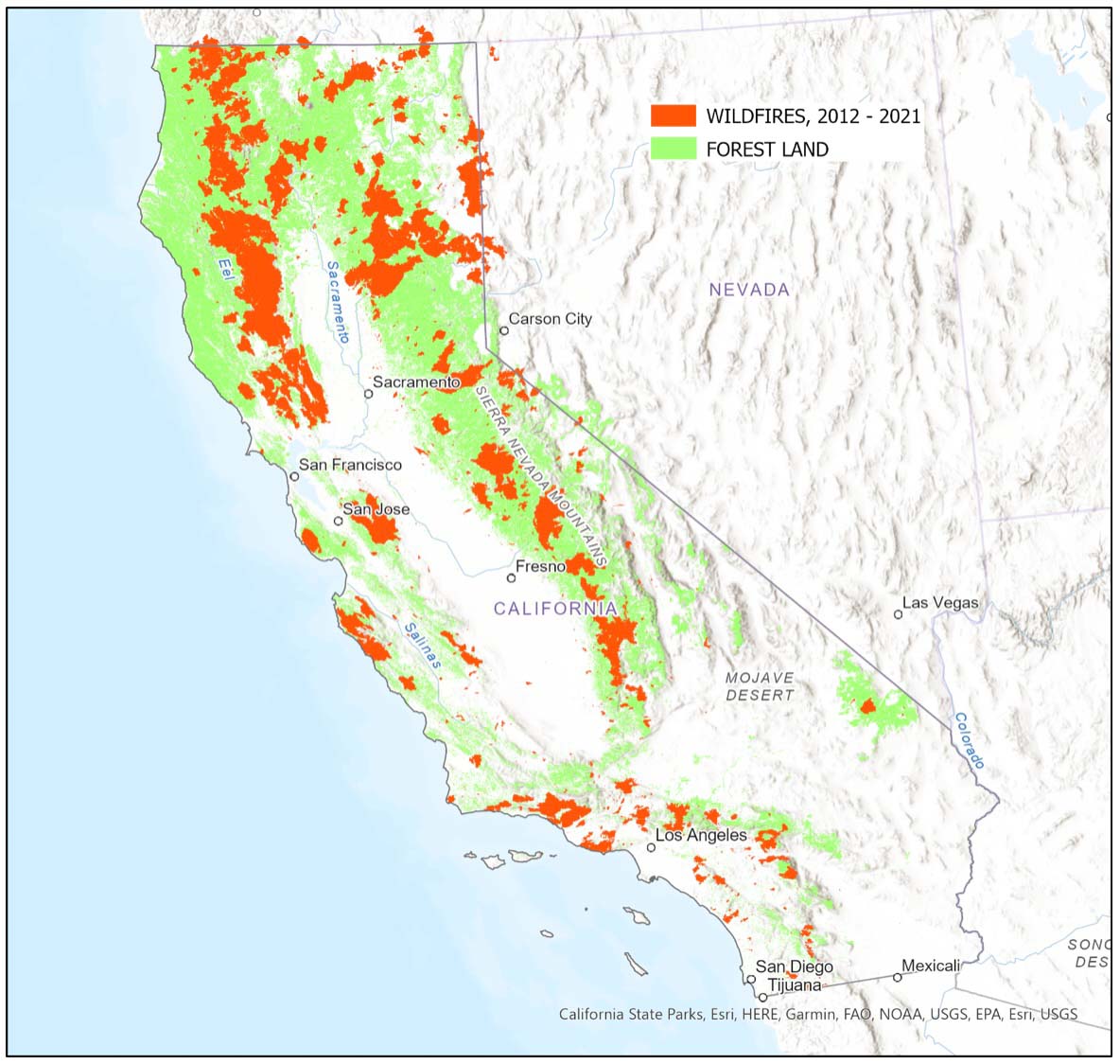
The following maps display the forestland areas and the areas that have burned in California in the last two decades. Fires were concentrated in Southern California in the 2002-2011 time period and in Northern California in the last 10 years.
California forestland and wildfires, 2002 – 2011. Jim SchmidtCalifornia forestland and wildfires, 2012 – 2021. Jim Schmidt
The article was edited September 7 with revised figures to account for areas that reburned, which account for about 5% of the forestland burned on National Forests in the last 20 years.
Jim Schmidt retired from the Stanislaus National Forest where he worked as a GIS specialist.
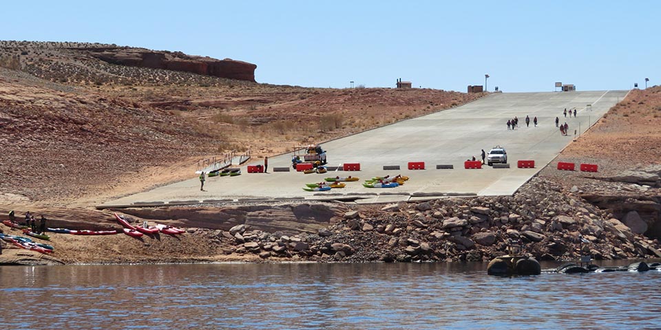
The public launch ramp at Antelope Point in late March, 2021 at Lake Powell, Glen Canyon National Recreation Area. NPS photo.
New research published this month shows that the current drought in the Western United States is the worst seen in data going back to the year 800. Scientists developed estimates of precipitation during previous centuries using tree-ring reconstruction and found 2000–2021 was the driest 22-year period in the last 1,200 years.
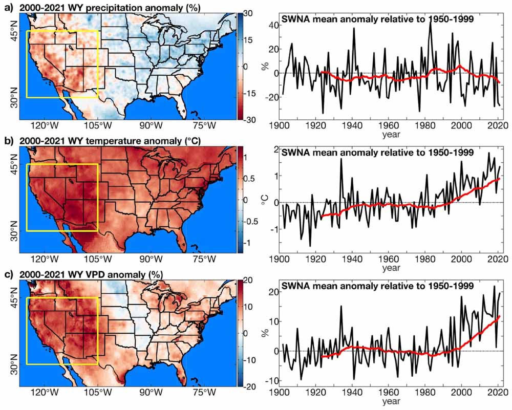
Observed climate anomalies. Anomalies in water-year (WY: October–September) (a) precipitation total, (b) temperature, and (c) vapour-pressure deficit (VPD). Maps on left show the average WY anomaly during 2000–2021. Yellow box: Southwestern North America (SWNA) study region. Anomalies are relative to 1950–1999. Time series on right show regionally averaged WY anomalies in SWNA (black) annually and as (red) 22-year running means visualized on the final year in each 22-year period. Geographic boundaries in maps were accessed through Matlab 2020a. From the paper.
Since the year 2000, southwestern North America (SWNA) has been unusually dry due to low precipitation totals and heat, punctuated most recently by exceptional drought in 2021. From 2000 to 2021, mean water-year (October– September) SWNA precipitation was 8.3 percent below the 1950–1999 average and temperature was 0.91 °C above average.
In summer of 2021, water levels at Lakes Mead and Powell, both on the Colorado River, reached their lowest levels on record, triggering unprecedented restrictions on Colorado River usage, in part because the 2-year naturalized flow out of Colorado River’s upper basin in water-years 2020–2021 was likely the lowest since at least 1906. Despite an active North American monsoon in 2021, the United States Drought Monitor classified more than 68 percent of the western United States as under extreme or exceptional drought for nearly all of July–October, 2021.
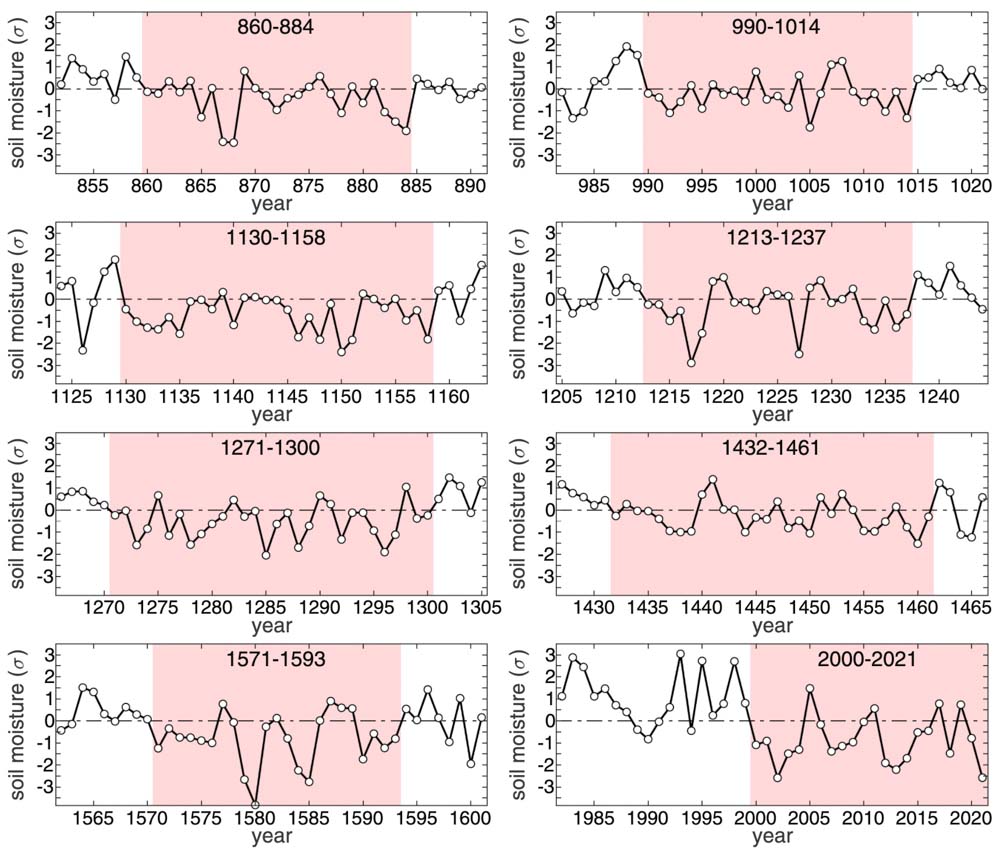
Extended drought events. Summer soil moisture anomalies, expressed as standard deviations from the 800–2021 mean (σ), during the longest 8 extended drought events during the 800–2021 study period. The pink background bounds the years of each extended drought event. The horizontal dotted black line represents the 800–2021 mean. For the first 7 droughts shown, soil moisture anomalies come from our tree-ring reconstruction. For the final drought (2000–2021), anomalies come from our observation-based record. From the paper.
The researchers concluded that anthropogenic climate change accounts for 42 percent of the SWNA soil moisture anomaly in 2000–2021 and 19 percent in 2021.
Drought can have a very significant effect on wildland fire behavior. It affects vapor pressure deficit (VPD), soil moisture, relative humidity, and moisture in live and dead vegetation, or fuels. VPD is an absolute measure of the moisture deficit of the atmosphere and is more closely related to water stress on vegetation than relative humidity.
Soil moisture is a particularly important integrator of drought. Of all 22-year periods since 800, only two (1130–1151 and 1276–1297) contained more years with negative soil moisture anomalies than the 18 observed during 2000–2021.
The authors wrote that the 22-year long current drought is highly likely to continue through a 23rd year.
Extreme and exceptional drought in the western United States (US). Weekly percentage of western continental United States (west of 103°W) classified by the United States Drought Monitor (USDM) as under extreme or exceptional drought from January 1, 2000 to December 28, 2021. Calculations were made form weekly shapefiles of USDM drought classifications, available at https://droughtmonitor.unl.edu/DmData/GISData.aspx as of January 9, 2022. The USDM is developed by the National Drought Mitigation Center (NDMC), the U.S. Department of Agriculture (USDA) and the National Oceanic and Atmospheric Administration (NOAA). From the paper.
The research was conducted by A. Park Williams, Benjamin I. Cook, and Jason E. Smerdon.
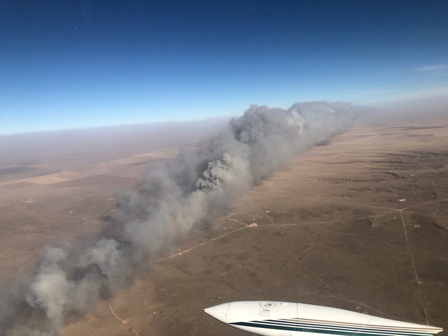
Smoke column from the Williams Fork Fire southwest of Fraser, Colorado, Aug. 15, 2020. USFS photo by Lauren Demos.
The Guardian has an excellent long-form article about wildland fires, titled ‘A deranged pyroscape’: how fires across the world have grown weirder. Author Daniel Immerwahr writes that in banishing fire from sight, we have made its dangers stranger and less predictable. He writes about fires around the world, pyrophobia, indigenous fire, and how hundreds of thousands die each year from such smoke-related maladies as strokes, heart failure and asthma.
Toward the end of the article he writes about fires in Indonesia where forests have been drained, burned, or clear cut, then summarizes.
Here is an excerpt:
…No single one of Indonesia’s many fires in recent decades has been especially noteworthy. But altogether they’ve been cataclysmic. In 1997, a dense haze of airborne particulates from Indonesia’s fires was perceptible as far as the Philippines and Thailand. That year, on Sumatra – centre of Indonesia’s fires – a commercial plane crashed due to poor visibility and killed all 234 aboard. The next day, two ships collided off the coast of Malaysia for the same reason, and 29 crew members died.
The economist Maria Lo Bue found that Indonesians who were toddlers during the 1997 haze grew less tall, entered school six months later and completed almost a year less of education than their peers. Another economist, Seema Jayachandran, found that the fires “led to over 15,600 child, infant and fetal deaths”, hitting the poor especially hard.
Picture a dangerous fire and you’re likely to imagine a thicket of tall trees blazing in a drought-stricken climate. But a more accurate image is smoldering peat or scrub burning by a tropical logging road. The real threat isn’t catching fire, but the slow violence of breathing bad air. You’ve got a hacking cough, your father suffers a stroke and you watch your daughter – short for her age – leave school a year early.
—
Fire is not in itself a bad thing. Many landscapes, built to burn, simply couldn’t exist without regular fires, either natural or intentional. Though foresters once sought to tamp blazes out everywhere, we now recognise that as a grave mistake. A fireproof planet isn’t something we can get, or should even want.
We badly need a healthier relationship to combustion. Rather than erratic, runaway fires, we need regular, restorative ones, like we used to have. Our forebears didn’t shun flame – they were relentless fire-setters. But they adhered to two important limits. First, they fed their fires with living vegetation, which reclaims lost carbon as it regrows. Second, they were guided by long-acquired experience with fire’s complex paths and consequences.
We’ve blasted far past both of those limits. We’re now burning fossilized vegetation, which sends carbon on a one-way trip to the warming atmosphere. And we’re kindling fires that bear little resemblance to the ones we’re used to. There’s no generational wisdom telling us what to do when we drain the peatlands of Central Kalimantan or let dry fuel pile up precariously in the California countryside, all while raising the temperature to hitherto unrecorded heights.
Booksaboutfire typically end with prescriptions: we must invest in science, reclaim lost cultural knowledge, burn intentionally, build resiliently, and power our grids renewably. All that is true, surely. But given how complex fire is, and how unprecedented nearly everything we’re doing with it is, the best advice would seem to be: slow down. We have scrambled our landscape, changed our energy diet, altered the climate and revised our relationship to flame, all in a very short time. It’s not a surprise that fire, once a useful if obstinate companion to our species, has now slipped our grasp.
The world won’t burn up, as we sometimes imagine. But the fires of tomorrow will be different from those of yesterday, and we’re racing headlong into that unsettling future, burning tankfuls of gas as we go.
A writer says, California’s “honeymoon is over for its residents now that wildfires are almost constant”
Parker Creek Fire, December 15, 2021. Texas Forest Service photo.
Sunday night as I watched the Season 4 finale of Yellowstone, John Dutton, played by Kevin Costner, was talking with another character who said, “I’m terrified of the world we’re leaving (for my grandchildren). I honestly don’t know what this place will look like in 100 years.”
“Grass will cover the streets, and weeds will cover the rooftops,” Dutton said. “I don’t think we make it 100 years.”
I have been thinking about wildfire smoke recently, and how during the last two years massive plumes of smoke from fires in the western states have often migrated east, sending hazardous air laden with tiny PM2.5 particles (2.5 micrometers and smaller) across a dozen states. I learned in a Smoke Management class that if you could drop a PM2.5 particle from eight feet high in a room with still air, it would take about eight hours for it to reach the floor. Smoke with these pollutants is easily transported hundreds or thousands of miles across state and international boundaries. Canada and the United States seem to take turns exporting PM2.5 across the border.
As the sun begins to set on the west coast, gray smoke from wildfires can be easily distinguished from white clouds. NOAA, GOES 17.
In research published online last week in the journal Toxicological Sciences, researchers reported that inhaled microscopic particles from woodsmoke such as PM2.5 work their way into the bloodstream and reach the brain, and may put people at risk for neurological problems ranging from premature aging and various forms of dementia to depression and even psychosis.
Extreme weather conditions that a few decades ago were rare are occurring more frequently, sometime establishing conditions suitable for extreme fire behavior. If this trend continues to increase, where will we be in 10, 20, or 30 years? Or 100 years? Grass on the streets and weeds on rooftops?
Widespread smoke is just one of the symptoms of how climate change is degrading the quality of life for many people on this planet. In the article described below, the author wrote that a researcher told her that “Wildfire is literally making it unsafe to be pregnant in California.”
The article by Elizabeth Weil published Monday in New York Times Magazine is well worth your time. It is a long form piece looking at how wildfires are changing, and the effects. She examines most of the issues that are involved — weather, climate, prescribed fire, indigenous fire, fuel breaks, “managed” fire, human health, fire resistant construction, and the home ignition zone — in a style that makes you want to keep reading, and hoping that you don’t get to the end of the article in the next paragraph or two.
It is behind a pay wall, but that’s the life we have now, or are moving toward. (Yes, even Wildfire Today has considered a subscription fee.)
Here are excerpts from the article, titled, This Isn’t the California I Married — The honeymoon’s over for its residents now that wildfires are almost constant. Has living in this natural wonderland lost its magic?
…Aching and eager to escape my own boring loop of depressive thoughts, I met with Alex Steffen, a climate futurist, on the back patio of a bar in Berkeley. Steffen, a 53-year-old mountain of a man with a crystal-ball-bald pate, hosts a podcast and publishes a newsletter called “The Snap Forward.” The idea behind both is that the climate crisis has caused us to get lost in time and space; we need to dig ourselves out of nostalgia and face the world as it exists. As he explained to me in his confident baritone, yes, California, and the world, are in bad shape. But the situation is not as devoid of hope as we believe. “We have this idea that the world is either normal and in continuity with what we’ve expected, or it’s the apocalypse, it’s the end of everything — and neither are true,” he said. That orange sky in 2020? “We’re all like, Wow, the sky is apocalyptic! But it’s not apocalyptic. If you can wake up and go to work in the morning, you’re not in an apocalypse, right?”
The more accurate assessment, according to Steffen, is that we’re “trans-apocalyptic.” We’re in the middle of an ongoing crisis, or really a linked series of crises, and we need to learn to be “native to now.” Our lives are going to become — or, really, they already are (the desire to keep talking about the present as the future is intense) — defined by “constant engagement with ecological realities,” floods, dry wells, fires. And there’s no opting out. What does that even mean?
We’re living through a discontinuity. This is Steffen’s core point. “Discontinuity is a moment where the experience and expertise you’ve built up over time cease to work,” he said. “It is extremely stressful, emotionally, to go through a process of understanding the world as we thought it was, is no longer there.” No kidding. “There’s real grief and loss. There’s the shock that comes with recognizing that you are unprepared for what has already happened.”
…
Relinquishing the idea of normal will require strength, levelheadedness, optimism and bravery, the grit to keep clinging to some thin vine of hope as we swing out of the wreckage toward some solid ground that we cannot yet see. “We’re no longer dealing with a fire regime in the woods that responds to the kinds of mild prevention and mild responses, the sensible responses we have thought about, and that thought alone is a crisis,” Steffen said. “It means the lives we had we no longer have.”
…
This brings us to one other forest- management tool in the knife: “managed wildfire.” This one, however, does not always pair well with the other overabundant species out there in California: people.
…
This summer, in Kings Canyon, as the wildfires approached, firefighters wrapped giant sequoias in aluminum foil. This included General Sherman — 2,200 years old and the largest single tree on Earth. This act was meager, and it was devotional. It’s what we’ve got now. The good news is, some of the moves we need to make are easier, more straightforward and more under our control than we imagined, if we’d just allow ourselves to get them done. The bad news is that there is just going to be loss. We’re not used to thinking about the world that way. We’re not used to paying for our mistakes.
The number of acres burned in US wildfires in 2020 (not counting Alaska) was the highest ever recorded since reliable statistics have been available beginning in 1960
New climate data analyzed by NOAA shows that during July when the fire season in the West is typically nearing its maximum, the temperatures in the 11 Western states have been rising in recent years. The data from the last 10 years also indicates the amount of precipitation in the Northwest has decreased significantly.
Every 10 years NOAA recalculates the U.S. Climate Normals for the previous 30-year period. Normals act both as a ruler to compare today’s weather and tomorrow’s forecast, and as a predictor of conditions in the near future. They consist of annual/seasonal, monthly, daily, and hourly averages and statistics of temperature, precipitation, and other climatological variables from almost 15,000 U.S. weather stations.
The new annual mean data for 1991 through 2020 shows that most of the U.S. was warmer, and the eastern two-thirds of the contiguous U.S. was wetter, from 1991–2020 than the previous normals period, 1981–2010. The Southwest was considerably drier on an annual basis, while the central northern U.S. has cooled somewhat.
The weather in July has a direct effect on the number of acres burned in Western wildfires. The new data shows the Northwest is considerably drier as a percentage of the previous normal during what is already a dry season.
The rest of the West is pockmarked with wetter and drier zones. The eastern two-thirds of the U.S. has an indistinct pattern of changes in the precipitation normals. Most of the East also remained near the same temperature levels, except for persistent cooling in the north central U.S. and warming in the Northeast. However, the entire West and lee of the Rocky Mountains and Texas are all considerably (up to 2°) warmer.
This warming and drying trend in the West shows up in wildfire activity. The number of acres burned in the U.S. in 2020 — 9,941,167 (not counting Alaska) — was the highest ever recorded since reliable statistics have been available beginning in 1960.
The average fire size by decade is striking, increasing by about 400 percent from the 1980s to the 2010s. Some of that increase could be from the tendency of the U.S. Forest Service and other federal agencies to allow some fires to spread without an aggressive full suppression strategy, allowing an unplanned wildfire to accomplish fuel reduction targets and other objectives. They can do this by using virtually unlimited fire suppression funds and without having to bother with pesky steps like conventional project funding, planning documents, approvals, public input, and environmental compliance required by the National Environmental Policy Act.