Fire at Big Sur burns homes, forces evacuations

(UPDATED at 11:35 a.m. PST, December 19, 2013)

Map of Pfeiffer Fire
Map of Pfeiffer Fire, looking northwest, showing the fire perimeter at 10:34 p.m. PST, December 18, 2013. (Click to enlarge)

An update from the Pfeiffer Fire Incident Management Team (IMT) at about 11 a.m. today revised the size to 917 acres and the containment to 79 percent. The evacuations of the Pfeiffer Ridge Road area remain in effect and the number of destroyed homes is still at 22. More information from the IMT:

Crews made good progress overnight in mopping up and strengthening lines in all areas of the fire. Structure protection continued as well. The expected strong winds which accompanied the cold front moved over the fire at approximately 10:00 pm. The stronger winds created a risk to firefighters from falling trees so crews were pulled off the lines to safety points and the fire was in a monitoring status for the remainder of the shift. Scattered rain occurred over the fire area.

QR code for Pfeiffer Fire maps

Maps of the fire can be found at the IMT’s Dropbox account. In an interesting twist, California Interagency Incident Management Team 7 did not place any maps on InciWeb, but instead posted an image of a QR code which when scanned with a barcode app on a smart phone will take you to Dropbox. If you viewed Inciweb with a computer or a smart phone, you would not have access to the maps, since neither the smart phone or a computer can scan an image on its own screen. You would have to view the QR code on one device and scan it with a second device. QR codes of map locations on the internet can be useful when printed on an Incident Action Plan handed out to firefighters, but an image of one on an internet site is difficult or impossible to use.
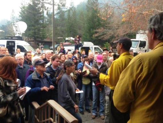
Community meeting at Pfeiffer Fire
Community meeting at Pfeiffer Fire, December 18, 2013. Photo by Manuel Madrigal.


****

(UPDATED at 10:00 a.m. PST, December 18, 2013)

According to the Forest Service, the Pfeiffer Fire on the California coast at Big Sur is now being called 50 percent contained after burning 850 acres and destroying 22 structures, including 14 homes along Pfeiffer Ridge Road. Firefighters were able to save 24 other structures directly threatened by fire. The Big Sur Volunteer Fire Brigade reports that although her home was lost in the early hours of the fire, their Fire Chief Martha Karstens remains dedicated to the Big Sur community by staying on-duty managing fire brigade resources and responding to emergency incidents.

They are expecting complete containment at 6 p.m. on Friday, December 20.

Evacuations of the Pfeiffer Ridge Road area remain in effect.

Air tankers have been grounded for portions of the last two days due to smoke causing visibility problems. However nine helicopters have been dropping water on the fire. Other resources assigned to the fire include:

  • 20 crews
  • 46 engines
  • 2 dozers
  • 4 water tenders, and
  • 879 personnel


****

(UPDATED at 5:50 p.m. PST, December 17, 2013)

The Los Padres National Forest reports that the fire is 20 percent contained and has blackened 769 acres — 22 structures have burned. Full containment is expected Friday evening.

****

(UPDATED at 3:12 p.m. PST, December 17, 2013)

A community meeting for the residents of Big Sur will be held this afternoon December 17 at 4:00 pm at the Big Sur Station, Highway 1, Big Sur, CA.

An update from the U.S. Forest Service puts the fire at 500 acres and 5 percent contained. However, heavy smoke and rough terrain make mapping the fire difficult. The fire behavior has been described as running, with spot fires igniting up to 1/4 mile ahead.

The 495 people assigned to the fire include 18 hand crews, 44 engines, 2 dozers, and 3 water tenders.

****

(UPDATED at 10:20 a.m. PST, December 17, 2013)
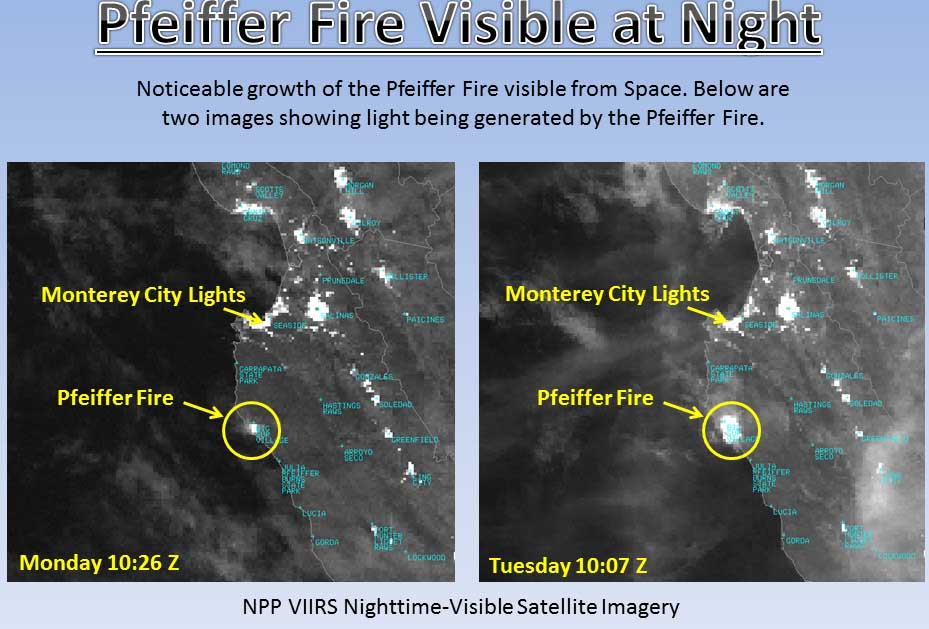
Pfeiffer Fire at night from space
Pfeiffer Fire at night from space, very early in the morning on Monday and Tuesday. Bay Area National Weather Service. Click to enlarge.

The cause of the Pfeiffer Fire at Big Sur, California that started between Pfeiffer Ridge and Sycamore Canyon has not been determined. The Associated Press is quoting a U.S. Forest Service spokesperson as saying Tuesday morning it has burned about 550 acres and is 5 percent contained.

The Big Sur Volunteer Fire Brigade reported Monday afternoon that 15 to 20 homes had burned but that due to heavy smoke in the area it was difficult to determine the exact numbers. The fire is west of Highway 1, which is still open.
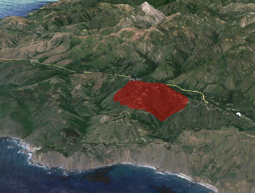
Map of Pfeiffer Fire
Map of Pfeiffer Fire, showing the APPROXIMATE location Monday night, December 17, 2013.

The map of the Pfeiffer Fire above depicts the approximate location of the fire based on data from a satellite which can detect heat.

The U.S. Forest Service is still responsible for suppression of the fire and has assigned 625 firefighters who were working under the direction of Curt Schwarm’s Incident Management Team. But at 6 a.m. Tuesday a Type 2 IMT will assume command, with Incident Commander Mark Nunez.

The weather forecast is more favorable for firefighters today, calling for much higher humidities of 30 to 35 percent, mostly sunny skies, and moderate winds. The wind should be 3 to 7 mph, but the direction could be quite variable, again providing a challenge for fire personnel.

At 9:04 a.m. today a nearby weather station recorded 66 degrees, 24 percent relative humidity, and a south-southeast wind of 2 mph gusting to 7 mph.

Continue reading “Fire at Big Sur burns homes, forces evacuations”

Holes in the Yarnell Hill Fire swiss cheese

In another thread there was a discussion about the Yarnell Hill Fire and the fact that when the 19 Granite Mountain Hotshots were killed there was only one aerial supervision aircraft over a very complex fire environment instead of two. Until recently it was more common to have both an Air Tactical Group Supervisor (ATGS) and a Lead Plane or Airtanker Coordinator over a fire that had advanced beyond initial attack.

The ATGS orbits the fire and coordinates, assigns, and evaluates the use of aerial resources, both helicopters and fixed wing. The Lead Plane directly supervises the air tankers, usually flying low and sometimes physically preceding the air tankers before they drop the retardant.

But now we sometimes see those two roles combined into one aircraft, called an Aerial Supervision Module. It can save money, but there is debate about how appropriate it is for a complex fire situation.

One of the recommendations in the first report issued about the fire, by the Arizona State Forestry Division last summer, was for the the State of Arizona to “request that the NWCG develop guidance to identify at what point is it necessary to separate the ASM and Air Attack roles to carry out required responsibilities for each platform”. Other documents released by the state of Arizona last week revealed that members of the Blue Ridge Hotshots said that they witnessed “a near miss” with aircraft, who they described as sounding “overwhelmed” adding that “the air show seemed troublesome.”

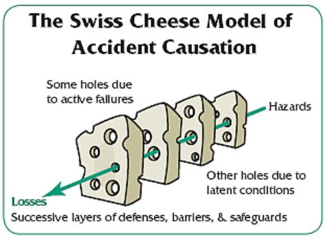
The aerial supervision on the Yarnell Hill Fire was only one element, or one slice of James T. Reason’s Swiss Cheese model of accident causation, which is defined in Wikipedia:

In the Swiss Cheese model, an organization’s defenses against failure are modeled as a series of barriers, represented as slices of cheese. The holes in the slices represent weaknesses in individual parts of the system and are continually varying in size and position across the slices. The system produces failures when a hole in each slice momentarily aligns, permitting (in Reason’s words) “a trajectory of accident opportunity”, so that a hazard passes through holes in all of the slices, leading to a failure.

Having only one aerial supervision platform on a very complex fire gives you one slice with some holes. Below we list 18 other holes in the Swiss cheese.

Swiss Cheese modelAnother slice would be supervision of ground personnel. The holes in that slice were:

  • Transitioning that morning from a group of firefighters to only a partial Incident Management Team (all transitions can be tough, but when done hurriedly and to only part of a team, it can be dangerous);
  • Removing Supt. Marsh from the Hotshot crew and making him Division Supervisor. (A reporter who has seen the recently released documents told me that Marsh did not know he would be Div. Sup. until he got out on the fire line that day);
  • No Safety Officer;
  • No Division Supervisors arriving with the IMTeam;
  • No Division Supervisor on the Division adjacent to the accident;
  • An Incident Commander that took over the fire about six hours before the accident;
  • Decision-making was poor, such as failure to designate division breaks, or decide on and communicate a firefighting strategy likely to be successful.
  • Somebody, either Marsh, a Structure Protection Group Supervisor, or an Operations Section Chief (or all of the above), decided for the Granite Mountain Hotshots to leave the safe previously burned black area and walk through unburned brush, where they were entrapped by the fire and killed.

Holes in the planning slice were:

  • No maps given to firefighters that day;
  • No Incident Action Plan that day or the two previous days;
  • There was a poor briefing that morning;
  • Marsh did not attend the briefing because it was given in mid-morning after he and his crew departed the Incident Command Post and headed to their assignment (Marsh did receive some briefing info that morning).
  • There was no complexity analysis completed on day one or day two (the accident occurred on day three of the fire, June 30.) It was completed three hours before the accident.
  • The number of firefighting resources working on the fire for the first three days was inadequate to safely implement the strategy of fully suppressing the fire and protecting the structures and the people in the communities.

Holes in the communication slice:

  • Incorrect radio programming information was given to firefighters that morning which made radio communication difficult;
  • The overhead, such as it was, did not maintain adequate communication with field personnel, which led to inadequate accountability of personnel who were in harms way;
  • Marsh and Granite Mountain did not clearly tell the Operations Section Chief where they were and where they were going when they left the secure black en route to the box canyon;
  • The ASM had difficulty communicating with Marsh and Granite Mountain as they became entrapped, possibly due to him being “overwhelmed” (as described by the Blue Ridge firefighters).

These slices have 19 holes, and when you place the slices next to each other, all it takes is one more hazard that then passes through holes in all of the slices, leading to an unfortunate outcome. Perhaps if one or more of the holes had been plugged by better management of the fire, there would have been a more favorable result.


Arizona releases Yarnell Hill Fire documents


Superintendent Eric Marsh
Superintendent Eric Marsh hikes ahead of his crew on the morning of June 30, 2013. Photo by Joy Collura.

The Arizona Republic obtained a large number of documents about the Yarnell Hill Fire from the Arizona State Forestry Division which provide more insight into the management of the fire. On June 30, 19 members of the Granite Mountain Hotshots were entrapped by the fire and killed.

Notes from interviews with firefighters further confirm and flesh out some of the issues that we knew from previous reports.

The two investigations completed so far about the fire revealed little if any interaction on June 30 between the Granite Mountain Hotshots and their day to day supervisor from the Prescott Fire Department, Darrell Willis, who was not in charge of the crew on that fatal day, but was a Structure Protection Group Supervisor attempting to prevent homes from burning in Yarnell. The Arizona Republic article said there was communication between Mr. Willis and the crew that day.

Darrell Willis of the Prescott Fire Department, who helped found the Granite Mountain Hotshots, told investigators he had pressed Marsh to complete a protective fire break around Yarnell before the accident, saying, “This thing is not anchored — we got to get an anchor on this thing.” The notes say Willis “seemed to have some ‘minor guilt’” in retrospect.

“This was the last conversation he had with Eric,” investigators wrote.

From that text, it is not clear WHEN Mr. Willis “pressed” Mr. Marsh, who is normally the Superintendent of the crew but was serving as Division Supervisor in charge of the area of the fire which included the Hotshots. If Mr. Willis’ conversation with Mr. Marsh resulted in a decision to move the crew from a safe, black, previously burned area, and walk through unburned brush into a box canyon where they were overrun by the fire, this is significant news, previously unreported.

This information, interpreted by a reporter from interview notes we have not seen, makes it sound like Mr. Willis wanted the Hotshots to construct a fireline around the town of Yarnell, but under the conditions that day, it is unlikely that would have been feasible, and was certainly too big a task for one crew.

We went back and reviewed the video recordings made by John Dougherty of Mr. Willis’ press conference at the scene of the tragedy. They were uploaded to YouTube on July 23 and 24 and are in two parts, Part 1 and Part 2. Below are transcripts of portions of Part 1:

3:12: Most of this information that I’m giving you is information that I gathered based on some of the information, maps, and stuff like that. I happened to be on the fire on the north end of the fire that day doing structure protection. So I wasn’t really involved with what they were doing but we are able to monitor the radio frequencies they were on and we heard that they were gonna move out and start coming in a southerly direction based on the fire behavior.

[…]

4:32: I believe that they were, felt that they weren’t doing good where they were at, they had to abandon their tactic of trying to anchor and flank the fire and go into what we call point protection, and that’s to move fire around the houses and protect structures. I believe that that’s what their intent was and when they moved down off of there you know they’re carrying 40 or 50 pounds of tools, equipment, and a pack, upwards of 70 pounds when you put a saw, fuel and stuff on their back and they were moving down to protect this house. That’s my theory on it. Like Jim Paxton said, we’ll never know, because we don’t know what 19 of the Granite Mountain Hotshots were thinking at that time and there’s no confirmation radio traffic that we’re aware of.

At first he said he heard on the radio “that they were gonna move out and start coming in a southerly direction based on the fire behavior”. And later said, when talking about why they moved from the black to where they became entrapped, “there’s no confirmation radio traffic that we’re aware of.”

The article also reported that members of the Blue Ridge Hotshots described the aerial firefighting personnel as sounding “overwhelmed”.

Visibility over the fire area during the entrapment and the effectiveness of air tankers due to smoke has been discussed before on Wildfire Today. According to the article, an air attack person said about the entrapment:

We have a crew in trouble. We are going to go look. … It was just a sea of black. … There was too much smoke.

In discussing the predictions of the weather moving into the fire area which caused the fire to change directions and increase in intensity, a meteorologist wondered at what point, during a chaotic incident like that, does weather information need to be translated into direct decision-support actions.

Below are some excerpts from the article.

****

“A group interview with four Blue Ridge Hotshot crew members provides the first detailed account of the day they spent working near the Granite Mountain team. The U.S. Forest Service, which employs them, refused to allow them to be interviewed for the workplace-safety investigation.

In one set of notes, members of the Air Attack crew — responsible for surveillance and assistance to air tankers — told investigators they did not realize they were in charge until minutes before the fatal burn-over, when another aircraft abruptly left the fire.

The air-crew members said they weren’t sure where to make fire-retardant drops as the blaze reversed directions and bore down on Yarnell with a 2-mile- long wall of flame.

At that moment, according to the interview notes, they heard a distress call over the radio — apparently from the Granite Mountain Hotshots — and called a ground supervisor to ask, “Do we stop and go look for the crew?” The answer came back: “No, they’re safe.”

Eric Marsh, a division supervisor with the Granite Mountain squad, calmly reported that they were OK, but moments later, the crew began calling for help, and Marsh followed with an announcement that the crew was trapped and would be deploying its fire shelters. [Note from Bill: according to previous investigation reports, the “calling for help” did not come “moments later”. It was much later.]

“I looked at (another crew member), and he did this (slash across the throat),” the Air Attack flier said in the interview. “We have a crew in trouble. We are going to go look. … It was just a sea of black. … There was too much smoke.”

[…]

Throughout the interviews, key figures in the fire-suppression effort criticized almost every aspect of planning, oversight and execution.

Members of the Blue Ridge crew said they dealt with a leadership dispute among supervisors and got no instructions, records show. They characterized the overall operation as “total non-stop chaos” and “Swiss cheese” because it was so full of holes.

[…]

The Blue Ridge members said that they witnessed “a near miss” with aircraft, who they described as sounding “overwhelmed” adding that “the air show seemed troublesome.”

[…]

Keeping track of the treacherous weather conditions also proved problematic before the tragedy. Some personnel said they hadn’t received updates; others had. Chuck Maxwell, a predictive meteorologist at the Southwest Coordination Center, told investigators that as storms moved toward the fire in the early afternoon, he warned about shifting winds. Maxwell believed there was “a generally high degree of situational awareness” about the approaching thunderstorm and its impacts.

In a separate synopsis recounting June 30, however, Maxwell wrote, “Things were in relative chaos” on the Yarnell and another blaze near Kingman that was competing for resources. Maxwell said he warned that conditions in Yarnell were similar to those that led to multiple fatalities in the Dude Fire.

He questioned whether he should have personally warned firefighters to get to safety, noting that his job was to support commanders and not get in the way.

“At what point within the chaos of an incident like this,” he wrote, “does the weather information need to be translated into direct decision-support actions?” “

The view from under a parachute canopy

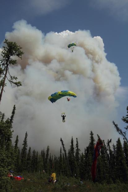
Hastings fire in Alaska, May 31, 2011. Two smokejumpers approach landing zone. Photo: Mike McMillan

Jon Marshall, a smokejumper at Missoula, has written an article about the current state of the smokejumper program. He looks at career development in the program, staffing levels, what it’s like to be a jumper, and the square vs. round canopy issue. You can red the entire article at his blog, but below is an excerpt:

****

I’ve loved living the life of a smokejumper. The people, the places, the experiences, the opportunities, the adventure; the skills, the training, the challenges, the obstacles, the fears and the insight that I’ve gained while employed as a smokejumper have given me an acute appreciation of what one is truly capable of if one puts their mind to it. I typically spend less than 20 minutes a year under canopy, but spend close to 6 months of my life away from home, dedicated to fire and the travel and the lifestyle associated with it. During that 6-month period I spend close to 100 days on active fire assignments and work nearly 800 hours of overtime, filling a variety of roles while making significant sacrifices to other aspects of my personal and professional life.

I enjoy the small initial attack fires with close friends, but I also grow from the challenges, personal tests and complexities found in incident command and on large project fires. I want to see this program move healthily forward into the future while providing it’s employees with the career opportunities and support that they deserve. The Smokejumper program is, at its core, the strongest Professional Development Program in the Forest Service, and in my opinion, one of the strongest in the country outside of the military. Individuals that leave the Smokejumper program go on to become extremely strong leaders, mentors and role models throughout this country. They pursue a wide range of careers from national incident managers and fire leaders to politicians to scientists to private business owners and entrepreneurs. I think it’s critical that we don’t lose sight of what this program really means to most of us; while truly recognizing how fragile it may really be.

Video records the last radio transmissions from Granite Mountain Hotshots

The video above, shot with a helmet camera, recorded the last two and a half minutes of radio transmissions with the Granite Mountain Hotshots before their radio contact was cut off as they were entrapped and killed by the Yarnell Hill Fire in Arizona on June 30, 2013.

Some of this radio conversation has already been released in the first report (on page 27) issued by the Arizona State Forestry Division in September. However, some parts were left out in that report, such as the exact wording of this:

Bravo 33: OK, unit that’s hollering in the radio, I need you to quit. And break, Operations, Bravo 33.

In the video, Bravo 33 was the Aerial Supervision Module, doing two jobs at the same time, Air Attack and Lead Plane.

My thoughts on the video are below, and following that is a transcript.

At 1558, 35 minutes before the first emergency transmission from Granite Mountain at 1633, the Air Tactical Group Supervisor, ATGS, abruptly left the fire and went to Deer Valley. He turned air tactical operations over to an Aerial Supervision Module, ASM2 or Bravo 33. Bravo 33 got a very brief update from ATGS that did not include division break locations and the location of the on-the-ground firefighters.

Bravo 33 was not briefed adequately and was overwhelmed with the duties of both the ASM and Lead Plane, and was no doubt communicating with multiple people on several frequencies. He had difficulty, as would anyone, attempting to do too many things at the same time during extreme conditions on the fire which was burning into Yarnell.

This is the problem with combining the two roles, which the U.S. Forest Service is doing more often, perhaps in an effort to save money. In this case, it contributed to confusion and one person being overwhelmed with his duties, which kept piling up.

The radio conversations pointed out that there may have been an unnecessary delay of more than two minutes in getting aircraft — helicopters and a Very Large Air Tanker — headed toward the approximate location of Granite Mountain, but their exact location was not known. Several people recorded by the video understood that Granite Mountain had a serious problem, but it took Bravo 33 about two minutes to absorb that information. He may have been dealing with other issues on other frequencies, while also serving as lead plane.

It is also possible that if Bravo 33 had been orbiting overhead instead of also having to act as lead plane, he might have been able to see the big picture on the fire and, in spite of the quick briefing he received, he may have figured out more quickly that the Granite Mountain Hotshots were walking into a death trap well before they met their demise.

However, even if there had not been the two minute delay, under the wind, vegetation, smoke, and extreme burning conditions it is unlikely that air tankers and helicopters if they had been over the Hotshots would have been able to save the crew. The rate of spread and intensity of the fire was extreme, and the strong wind would have blown the retardant or water off target. In the smoke the pilots probably would not have been able to see the firefighters. And the fire would have burned through the retardant even if it had landed in the desired location.

Aerial fire resources are not effective in extreme wind and burning conditions.

Below is the official transcript provided with the video:
Continue reading “Video records the last radio transmissions from Granite Mountain Hotshots”

Wildfire briefing, December 13, 2013

Airbus completes second round of tests of C295 airtanker

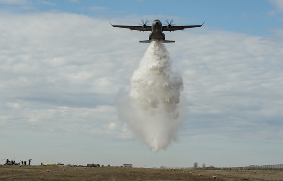
C295 water drop test.
C295 water drop test. Airbus photo.

Airbus is experimenting with a C295 that has been converted into an air tanker. The first tests were designed to monitor the performance of the aircraft as the water was released. In the second phase the company conducted seven water drops at a range near Cordoba, Spain where water was dropped into a grid of cups which measured the amount of water. After the engineers analyze the data they will know the volume and consistency of the drop pattern across the grid. The Interagency AirTanker Board requires similar tests before issuing federal certification for air tankers in the United States.

Fire Aviation has the rest of the story.

Western Governors prepared to do more to fight wildfires

At a meeting of the Western Governors Association on Thursday some of the state representatives said that in light of tight budgets at the federal level they are willing to spend more of their own resources to fight fires in their states. However not all of the governors at the conference shared that position, as reported by KTVN:

Nevada Gov. Brian Sandoval was alone in making an outright plea for federal firefighting resources. He said the Silver State should be entitled to more federal attention because it is home to more federal lands.

His fellow governors groaned and shook their heads, and [Idaho Governor C.L. “Butch”] Otter joked that someone should shut off the Nevada governor’s microphone.

Governor John Hickenlooper of Colorado said that in addition to studying the possibility of establishing an aerial firefighting fleet, “the state is considering taking other local measures, including mandating that buildings use fire-resistant materials, and requiring property owners to disclose wildfire risks to potential buyers the same way they must disclose flood risks”, according to the KTVN report.

Granite Mountain Hotshots’ tribute fence items being preserved

After 19 members of the Granite Mountain Hotshots were killed while fighting the Yarnell Hill Fire on June 30, family members, friends, and strangers left thousands of memorial items on the fence bordering the Prescott, Arizona fire station base of the crew. All of the items were removed a few weeks ago and are painstakingly being cataloged and preserved by volunteers. Below is an excerpt from an article at the Prescott Daily Courier:

Volunteer Deborah Balzano, who has devoted four days a week to the effort, said the process has been overwhelming at times.

“One day, I really lost it,” she said. “I found an infant’s onesie with the words, ‘My daddy is a hero.'”

And just like the fence served as a forum where the community could show its grief, volunteers say the preservation process has helped them deal with the tragedy.

“I wanted to do something,” volunteer Marian Powell explained on Thursday. “That was the same motivation people had for putting things on the fence – they wanted to do something. This is my way to do something.”

Volunteer Ered Matthew said that, for many, the fence served as “therapy through art and creating something.”

Ted Pohle, a retired schoolteacher, said he found the children’s tributes – including many miniature toy fire trucks – especially touching.

USFS awards sole source air tanker contract to Neptune

On Thursday the U.S. Forest Service awarded a sole source contract to Neptune Aviation to supply two next-generation air tankers for the next four to nine years beginning in 2014. The estimated value of the contract is $142,000,000 and has a base period of four years with the possibility of adding five more.

The details are at Fire Aviation.

Forest Service not using $100,000 worth of drones

The U.S. Forest Service spent $100,000 in 2007 to buy two Sky Seer drone aircraft that they have not figured out how to use. Apparently the agency purchased the drones seven years ago initially to be used for law enforcement, but FAA regulations and other problems have presented obstacles to the very expensive unmanned aerial vehicles (UAV) taking to the skies.

The details are at Fire Aviation.