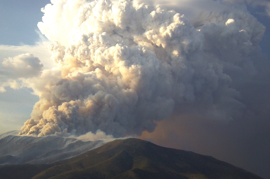
The Carpenter 1 fire west of Las Vegas is winding down, but that was not the case on July 5 when Zak took this photo from the back seat of a helicopter.
News and opinion about wildland fire
(UPDATE at 11:55 a.m. MDT, July 16, 2013)
The system seems to be back up and running.
****
Some of the wildland fire-related software programs administered by the Bureau of Land Managment suffered an outage overnight and are still down. One of the programs is the Wildland Fire Management Information system that provides data collected by the Remote Automatic Weather Stations (RAWS) which record critically important weather information for wildland fire managers, planners, dispatchers, and weather forecasters.
Kari Boyd-Peak of the BLM said, “We were notified that the appropriate personnel were aware of the problem and [they are] taking steps to solve it, but unsure of time frames at this time.”

Red Flag Warnings and Fire Weather Watches for enhanced wildfire danger have been issued by the National Weather Service for areas in Washington, Idaho, Oregon, California, and Nevada.
****
The Red Flag Warning map above was current as of 10:49 a.m. MDT on Tuesday. Red Flag Warnings can change throughout the day as the National Weather Service offices around the country update and revise their forecasts. For the most current data, visit this NWS site.
The Arizona State Forestry Division has issued a report that summarizes information about some of the major events and the firefighting resources that were deployed for the Yarnell Hill Fire on which 19 members of the Granite Mountain Hotshot crew were killed.
A very quick summary: according to the report, 24 hours after the Yarnell Hill Fire was reported, it had burned only 6 acres — 23 hours after that 19 firefighters were dead. It seems too unlikely to believe.
Below are some highlights of the report, but you can read the entire report HERE.
Friday, June 28, 2013
The fire, caused by lightning, was reported at 5:40 p.m. The Yarnell Volunteer Fire Department responded, but they were not sure they could access it. The fire was not staffed at night for safety and lack of access reasons. The last reported size that day was one acre. Air Attack flew over the fire but there was no mention of any helicopters or air tankers being used. There were multiple lightning-caused fires in that part of the state.
A spot weather forecast from the National Weather Service predicted for Saturday, hot (102-104 degrees), dry (10-11% relative humidity), winds light (W-SW 6-10 gusts to 14 m.p.h.), very little relative humidity recovery at night, and the possibility of high based showers or thunderstorms with a slight chance of moisture. If thunderstorms developed, the fire area could experience gusty winds.
Saturday, June 29, 2013
Six firefighters were flown in to the fire and began work. They estimated the fire had burned two to four acres.
Continue reading “Report issued about resources deployed on Yarnell Hill Fire”
(UPDATE at 9:20 a.m. PDT, July 21, 2013)
Monsoonal storms brought heavy rain to the Mountain Fire west of Palm Springs early this morning. The weather station at the top of the Palm Springs Aerial Tramway just north of the fire measured 1.61 inches between 11 p.m. Saturday and 8:53 a.m. today. The Keenwild weather station 5 miles southwest of the fire had 0.23″ since midnight. A flash flood watch was issued for the fire area as well as the Riverside County Mountains, San Diego County mountains and San Diego County deserts. There is a 55 to 80 percent chance of more rain through 10 p.m. with additional accumulations of up to 0.60 inch.
This morning the incident management team said firefighters are taking advantage of the break in the weather:
With diminished fire activity, firefighters made great progress with line construction particularly along the East side towards Palm Springs. Although conditions were hazardous and some crews were taken off the line due to the severe weather, firefighters continue to fight the fire aggressively where possible. Todays priority for fire operations is focused at the northernmost part of the fire with crews at the Palm Springs Aerial Tramway constructing direct hand line at the fires edge to reduce the threat to Idyllwild and surrounding communities.
The U.S. Forest Service has been using their new night flying helicopter and air attack ship on the fire, and proudly produced this graphic.
****
(UPDATE at 7:25 a.m. PDT, July 20, 2013)
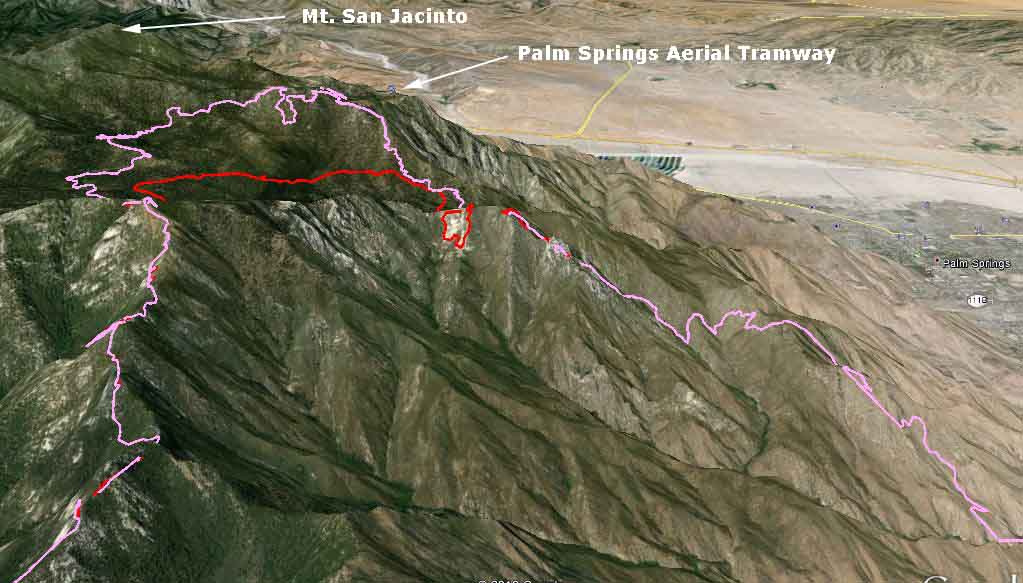
The Mountain Fire continued to spread to the north Friday, coming closer to the highest point in the area, Mt. San Jacinto, and within 0.7 mile of the Palm Springs Aerial Tramway. The 3-D map above which shows the north portion of the fire illustrates the very steep slopes the firefighters have as their work environment. The fire spread very slowly on the south side, while the east and west sides were relatively quiet Friday.
A major change in the weather is in the works, with the forecast for the higher elevations calling for much higher humidity and a 30 to 40 percent chance of showers over the next 48 hours. This should slow the fire’s spread and give firefighters a better opportunity to construct more direct fireline.
The incident management team has produced a map of the fire.
****
(UPDATE at 9:23 a.m. PDT, July 19, 2013)
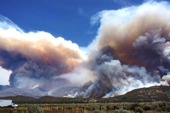
The variable wind direction Thursday caused the fire to spread, as expected, in multiple directions. It continued to progress in the Tahquitz meadows area, but firefighters on the ground assisted by aircraft, including two military MAFFS C-130 air tankers from the California Air National Guard, held the fire at a ridge. The fire remains active on the north side and continues to threaten the community of Idyllwild, according to the Incident Management Team.
The IMTeam produced a very readable map, below. It was released at 6 a.m. July 18 and contains the fire perimeter as it was known late in the day on July 17.
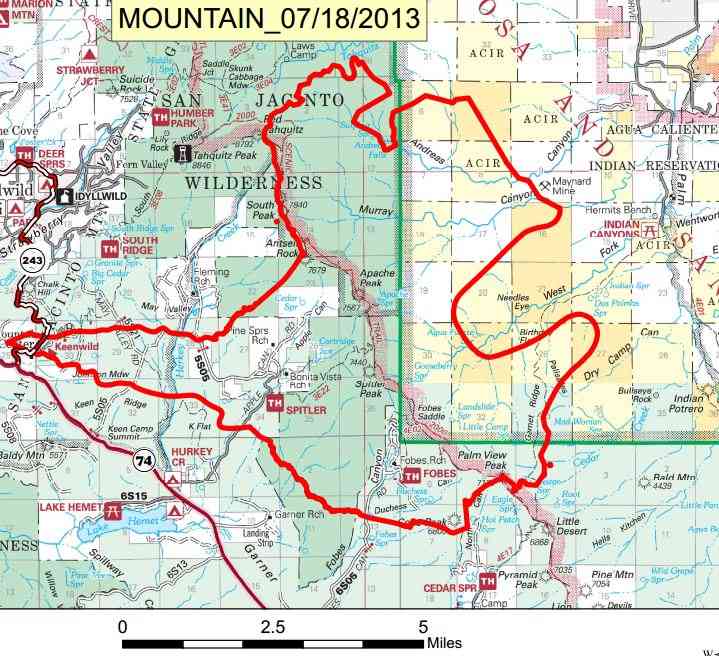
We put together the following maps using data from various sources.
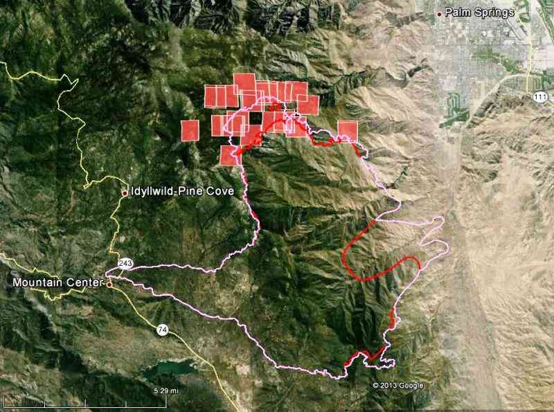
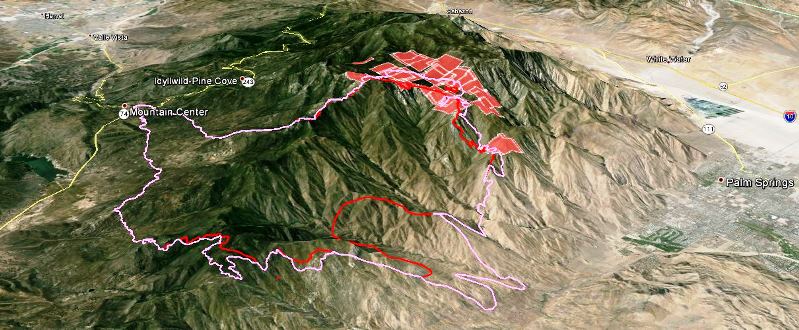
****
(UPDATE at 7:41 a.m. PDT, July 18, 2013)
We collected some interesting videos of the Mountain Fire HERE.
The maps below show the perimeter of the Mountain fire as it was mapped at 9 p.m. Wednesday.
Continue reading “California: Mountain Fire”