Shirley Fire, near Lake Isabella, California

(Information about the Way Fire that started August 18, 2014 north of Highway 155 near Wofford Heights and Kernville, can be found HERE. The article below is about the Shirley Fire, of June, 2014))

***********

(UPDATE at 8:47 a.m. PT, June 17, 2014)
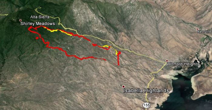
Map of the Shirley Fire
3D Map of the Shirley Fire. The red line was the perimeter at 9:30 p.m. PT June 16. The yellow line is about 24 hours earlier.

Below is an update on the Shirley fire near Wofford Heights, California, provided by the Incident Management Team at about 8:30 a.m. PT Tuesday:

Excellent progress made over the previous 24 hours on all areas of the fire perimeter has enabled firefighters to raise containment to 75%. Burning operations used yesterday to widen lines in Division Y, held throughout the night. A wind advisory issued for the Kern Valley and will remain in place until Tuesday afternoon, wind speeds are expected to reach up to 45 MPH. Crews will be cautious of the possibility of blowing embers causing spot fires outside the line as they work to improve containment. Safety remains a concern as steep rocky terrain, tree snags and rolling material from the fire are in all areas of the fire. Last nights community meeting was attended by approximately 120 people and was streamed live to another 1100 viewers and can be seen at https://www.youtube.com/watch?v=Bf4hf0WRj8g

Today, crews will continue to hold and improve containment lines and mop up interior to the perimeter. Demobilization of resources will begin today as firefighters return home to prepare and train for the additional wildland fires to come.

The official size is 2,646 acres.

****

(UPDATE at 9 p.m. PT, June 16, 2014)

A community meeting for the Shirley Fire was broadcast live on YouTube Monday night. It started at 7 p.m., and got off to a slow start with a long speech from the Kern County Fire Chief.

Incident Commander Jeanne Pincha-Tulley came on and said they have a line around the entire fire but they are not calling it contained yet.

They said the fire has burned 2,646 acres. The Incident Management Team is calling it 75 percent contained. All evacuations for the fire have been lifted.

Incident Commander Pincha-Tulley in attempting to answer a question about where the three homes that burned were located, said she knew the general area where the losses occurred, but not being from the area, she did not know how to describe the general location to the audience. She said she was not being flippant.

Broadcasting the community meeting live on YouTube was a great idea, at least in concept. On our end, there were quite a few interruptions in the video with a lot of stopping and buffering, while we watched the circle of dots go around and around. Viewers could leave live comments on the website, and many others confirmed that they too were affected by the interruptions in the video.

It was odd that there was no organized attempt to provide a general briefing to the community members about the status of the fire. After they opened it up to questions, one of them, about 30 or 40 minutes into the meeting, was how many acres had burned and how much of the fire was contained. And no one was prepared to answer a question from the audience of where the three burned homes were located.

There may be a recording of the video available later on YouTube, and hopefully it won’t have all of the buffering interruptions. If so we will add the link to it here.

UPDATE at 9:20 p.m. PT, June 16, 2014: A recording of the meeting can be seen on YouTube. In the video, the meeting actually starts at about 48:30. After preliminary information from the host and the Kern County Fire Chief, the meat of the meeting begins at 1:02:33 when the local USFS District Ranger makes a brief comment just before the Incident Commander comes on.

****

(UPDATE at 7:42 a.m. PT, June 16, 2014)
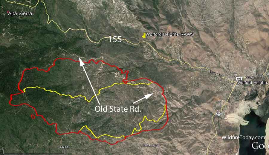
Map Shirley Fire 930 pm June 15
Map of the Shirley Fire. The red line was the perimeter at 9:30 p.m. June 15, 2014. The yellow line is from about 24 hours earlier. (click to enlarge)

The Shirley Fire west of Wofford Heights was very active on Sunday, growing by over 1,000 acres primarily on the north side but it also expanded on the southeast side. This brings the total area burned to 2,600 acres according to the map and information we have received, but the Pincha-Tulley Type 1 Incident Management Team reported at 8 a.m. Monday that the fire had only burned 2,200 acres. They are calling it 10 percent contained. New information from the Team has been rather sparse, but the National Interagency Fire Center reports that two structures have been destroyed. It is unknown if they were residences or outbuildings.

The fire is being fought by 1,176 personnel, with 73 engines, 4 helicopters, and 29 crews at a cost so far of $4.2 million. Air tankers, including one of the DC-10s flying out of Santa Maria, also were busy over the fire on Sunday. Night-flying helicopters from the Kern County Fire Department have also been used after sunset when the other aircraft are grounded.

As the fire spreads to the east it moves from conifers above 5,000 feet to lighter vegetation below 4,000 feet. In the lower elevations the fuels transition to brush and grass, conditions under which the air tankers and helicopters working with the firefighters on the ground can be more effective.

On Sunday the firefighters were faced with winds gusting up to 27 mph. The forecast for Monday is somewhat better, but not great, calling for 5 to 9 mph winds out of the west in the morning, becoming stronger by late afternoon at 15 mph gusting to 21 from the west and northwest.

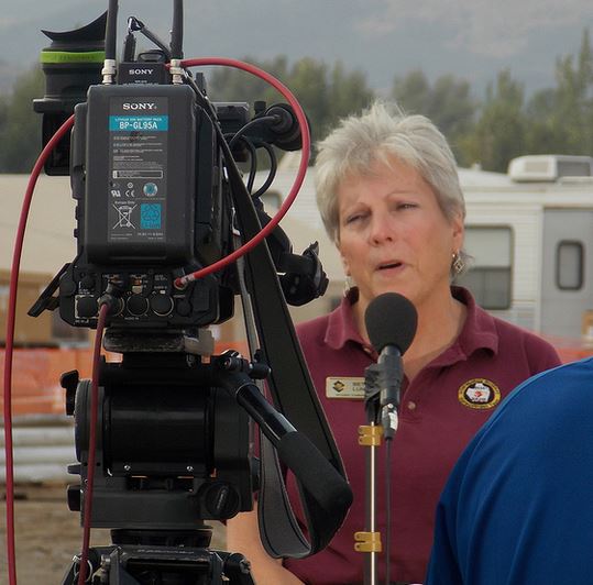
The cameraman in the above photo is wearing an interesting combination of clothing — what appears to be a fire resistant Nomex shirt or jacket, and shorts.

Continue reading “Shirley Fire, near Lake Isabella, California”

Beth Lund, Incident Commander on the Beaver Creek Fire

Beth Lund, Incident Commander
Beth Lund, Incident Commander. Incident Management Team photo.

Beth Lund is one of two female Incident Commanders on Type 1 Incident Management Teams, the largest and most capable teams that run large incidents. Jeanne Pincha-Tulley is the other.

Ms. Lund’s Type 1 Team has been managing the Beaver Creek Fire near Ketchum, Idaho which is one of the fires getting a lot of national media attention due to the number of acres burned, 111,000, and the movie stars homes that have been threatened by the fire. The Idaho Mountain Express has an article about her. Here is an excerpt:

In the modern world of firefighting, mavericks are discouraged, a strong and flexible mind excels and only quiet competence is rewarded.

It’s in this world that a 58-year-old woman, who is halfheartedly eyeing a retirement in which she will learn to quilt, has risen to become the face of fire news at its best and worst.

She is one of only two women in the already tiny national cadre of 16 U.S. Forest Service Type I incident commanders—the people who try to tame the most complicated wildland fires.

“My policy is to tell what I know and to tell the truth while being mindful that we don’t want people to hear it from the news first,” says Beaver Creek Fire Incident Command Leader Beth Lund.

She’s been the calm center in a relentless stream of media and public inquiry since arriving nearly two weeks ago to manage and expand the efforts to repel the fire that threatened the length of the Wood River Valley.

Even in the diciest moments as she bounces from gathering recon to live TV on demand, to fielding questions from strangers, with nearly every step she takes, she remains unflustered—even when she delivers unsavory news.

Traci Weaver and Beth Lund
Traci Weaver and Beth Lund accept a card from the Wood River community. Incident Management Team photo.
Burnout operation on the Beaver Creek Fire
Burnout operation on the Beaver Creek Fire. Incident Management Team photo.


NPR profiles Jeanne Pincha-Tulley

Jeanne Pincha-Tulley has been a Type 1 Incident Commander for nine years. Almost long enough for the novelty of having a female Type 1 IC wear off among other firefighters.

While her team was managing the Mountain Fire in southern California last month between Idyllwild and Palm Springs, National Public Radio did a profile on her. You can listen to it or read the article at the NPR site.

Below is an excerpt from the article:

…Pincha-Tulley listens and texts other members of the team while Lane continues with his update. Being in the incident commander’s trailer is like being in a hive. There’s a near-constant buzz.

People come in and out; phones ring; radios squawk; lunches go uneaten.

In the time it takes [Operations Section Chief John] Lane to give an update, the area fire chief for Cal Fire walks in, as well as a liaison for the sheriff’s office, a member from communications and a guy from finance. Pincha-Tulley scribbles her signature on a form as a radio update comes in.

“And secondly, the retardant line with the helicopter across that ridge there heading towards the wilderness is progressing really well,” according to the update.

Lane then explains that the fire has crossed over their containment line in one section. They’re calling in the largest air tankers, DC-10s — or VLATs for Very Large Air Tankers, as firefighters call them — to try to box in the new threat before it spreads. Pincha-Tulley asks how that’s progressing when the radio squawks again: “So far we’ve been pretty successful with that.”

“There’s your answer,” Lane tells her. “It’s being dealt with.”

In 2008 and 2010 Ms. Pincha-Tulley was in the news for managing the 48,520-acre Castle Rock Fire in Idaho as well as other fires, here, here, and here.

California: Mountain Fire

(UPDATE at 9:20 a.m. PDT, July 21, 2013)

Monsoonal storms brought heavy rain to the Mountain Fire west of Palm Springs early this morning. The weather station at the top of the Palm Springs Aerial Tramway just north of the fire measured 1.61 inches between 11 p.m. Saturday and 8:53 a.m. today. The Keenwild weather station 5 miles southwest of the fire had 0.23″ since midnight. A flash flood watch was issued for the fire area as well as the Riverside County Mountains, San Diego County mountains and San Diego County deserts. There is a 55 to 80 percent chance of more rain through 10 p.m. with additional accumulations of up to 0.60 inch.

This morning the incident management team said firefighters are taking advantage of the break in the weather:

With diminished fire activity, firefighters made great progress with line construction particularly along the East side towards Palm Springs. Although conditions were hazardous and some crews were taken off the line due to the severe weather, firefighters continue to fight the fire aggressively where possible. Today’s priority for fire operations is focused at the northernmost part of the fire with crews at the Palm Springs Aerial Tramway constructing direct hand line at the fire’s edge to reduce the threat to Idyllwild and surrounding communities.

The U.S. Forest Service has been using their new night flying helicopter and air attack ship on the fire, and proudly produced this graphic.

Night flying data, Mountain Fire

****

(UPDATE at 7:25 a.m. PDT, July 20, 2013)

3-D Map of Mountain fire, perimeter,
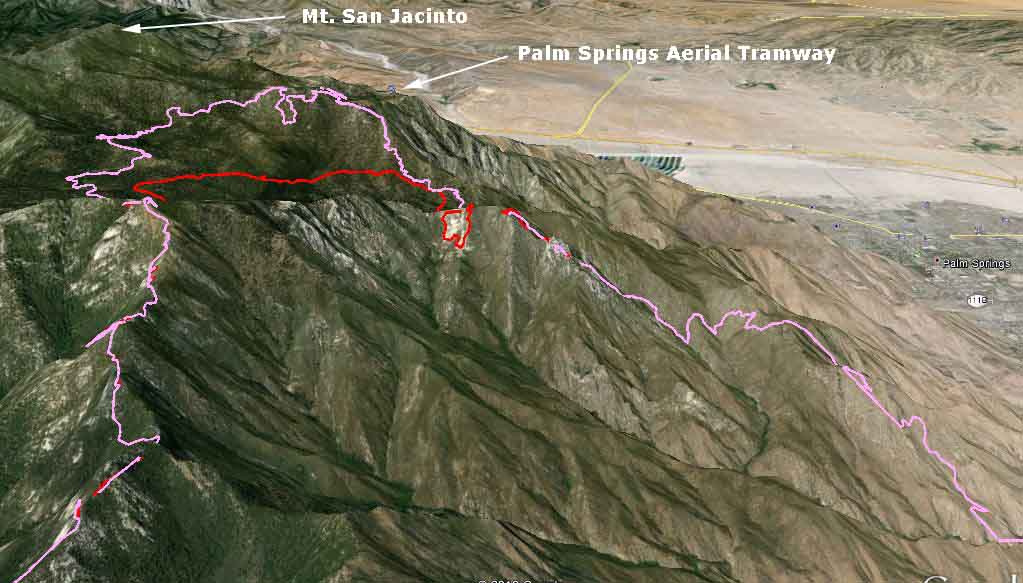
3-D Map of the north side of the Mountain fire, at 10 p.m., July 19, 2013, looking north. The pink line was the perimeter at 10 p.m. Friday, and the red line was 24 hours before that. (click to enlarge)

The Mountain Fire continued to spread to the north Friday, coming closer to the highest point in the area, Mt. San Jacinto, and within 0.7 mile of the Palm Springs Aerial Tramway. The 3-D map above which shows the north portion of the fire illustrates the very steep slopes the firefighters have as their work environment. The fire spread very slowly on the south side, while the east and west sides were relatively quiet Friday.

A major change in the weather is in the works, with the forecast for the higher elevations calling for much higher humidity and a 30 to 40 percent chance of showers over the next 48 hours. This should slow the fire’s spread and give firefighters a better opportunity to construct more direct fireline.

The incident management team has produced a map of the fire.

****

(UPDATE at 9:23 a.m. PDT, July 19, 2013)

Mountain Fire, from Hwy 74
Mountain Fire, from Hwy 74, July 17, 2013 USFS Photo by Sam Wu

The variable wind direction Thursday caused the fire to spread, as expected, in multiple directions. It continued to progress in the Tahquitz meadows area, but firefighters on the ground assisted by aircraft, including two military MAFFS C-130 air tankers from the California Air National Guard, held the fire at a ridge. The fire remains active on the north side and continues to threaten the community of Idyllwild, according to the Incident Management Team.

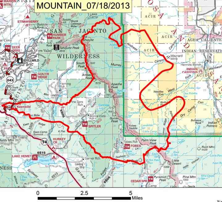
The IMTeam produced a very readable map, below. It was released at 6 a.m. July 18 and contains the fire perimeter as it was known late in the day on July 17.

Map of Mountain Fire
IMTeam map of Mountain Fire, July 18, 2013

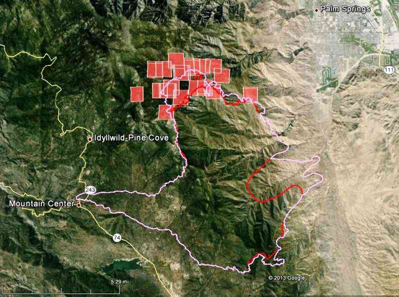
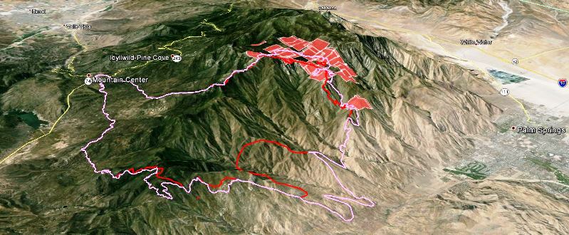
We put together the following maps using data from various sources.

Map of Mountain fire July 19, 2013
Map of Mountain fire. The white line is the perimeter at 9 p.m. PDT July 18. The red line is the perimeter 24 hours before that. The red squares represent heat detected by a satellite at 2 a.m. PDT July 19, indicating that the fire continued to spread to the north during the night. The apparent growth on the east side is most likely not new growth, but is probably a correction, showing movement of the fire several days earlier.  (click to enlarge)
Map of Mountain fire, July 19, 2013
3-D Map of the Mountain fire, looking toward the northwest. The white line is the perimeter at 9 p.m. PDT July 18. The red line is the perimeter 24 hours before that. The red squares represent heat detected by a satellite at 2 a.m. PDT July 19. (click to enlarge)

****

(UPDATE at 7:41 a.m. PDT, July 18, 2013)

We collected some interesting videos of the Mountain Fire HERE.

The maps below show the perimeter of the Mountain fire as it was mapped at 9 p.m. Wednesday.
Continue reading “California: Mountain Fire”

Profile of a “legal pyro”

The High Country News has an article about Jeanne Pincha-Tulley, the forest Fire Management Officer on the Tahoe National Forest in California. Ms. Pincha-Tulley has achieved what no other person of her gender has… the qualification of Type 1 Incident Commander.

The article, in which she calls herself a “legal pyro”, is very worth reading, but here are a couple of excerpts:

Jeanne Pincha-Tulley. Photo: Kari Greer

In late August 2007, lightning ignited the Castle Rock Fire in Idaho’s Sawtooth National Forest. More than 10,000 acres had been blackened by the time Pincha-Tulley’s team was summoned. Computer models showed the winds from an approaching cold front posed “a 99-percent chance the town of Ketchum would burn down.”
Pincha-Tulley immediately called a town meeting. Hundreds of frightened residents — “inching toward panic due to the proximity of the flames and the dearth of information,” according to the Idaho Mountain Express — crowded into Ketchum’s Hemingway Elementary School gym to hear the new fire boss explain the aggressive line-building and burnout tactics she planned along the ridge of Mount Baldy.

“We’re going to put a dozer line down your favorite trail,” she warned them. “We’re going to do strafing runs over your house. We’re going to land helicopters in your backyard. We’re going to burn the views you love, turn them black. …”

Instead of reacting in horror, they applauded. Pincha-Tulley’s straightforward manner and clear explanation inspired confidence. “In all of our careers,” District Ranger Kurt Nelson later declared, “we’ve never seen anything like this, where a community, faced with fire breathing right down on (it), had the ability to pull together and actually trust the Forest Service.”

That faith was rewarded. Some 1,400 residents were evacuated and 48,000 acres ultimately charred, but not a single home burned and no one was injured.

[…]

Combating fires along the West’s wildland urban interface “is really an art form in terms of applying the science,” she says. “You have to use your intuition. A large part of what you do also comes from knowing who you’re working with … knowing your team, knowing each others’ strengths and weaknesses. We usually spend five or six years at a time together, and the team becomes your second family.

I have a great group of renegades that I adore,” she continues. “We’re known for playing jokes on people … and being serious when we need to be serious … throwing just enough levity in so that people can stop … breathe. We have a grand time!”

Turning earnest, she adds, “Our mission is to safely do the impossible in very short order. And sometimes,” she cracks before bursting again into laughter, “we actually can do it!”

We have written about Ms. Pincha-Tulley before.

Thanks Dick

Newspaper story: not enough firefighters

Reporters for the Mercury News in Silicon Valley in California reviewed Incident Status Summary forms, ICS-209’s, from many of the California fires and harvested narrative comments from the forms regarding the availability of resources. The entire article is worth reading, but here are a few excerpts:

“A shortage of equipment and manpower has contributed to the spread of fires across the state, according to frustrated fire commanders trying to subdue the state’s 320 raging wildland blazes.

Internal reports from experts out in the field reveal repeated requests for additional help – and concern for their firefighters’ lives.

“All fires on the Complex are minimally staffed . . . Due to limited resources, there are some divisions unstaffed,” according to an incident status summary by Ron Roberts at the Shasta and Trinity County fire, the site of 34 injuries. “Operational adjustments have been made due to the lack of resources.”

In Kern County’s Piute Fire, commander Chris Hoff asked repeatedly for more officers, writing “Lack of overhead positions continue to hamper suppression efforts.” In a Humboldt County fire, called Hell’s Half Complex, commander Jess Secrest wrote that “Continued inability to fill critical resource orders increases the fire’s ability to enter residential areas, expected later this week.”

More than 700,000 acres have burned – and 99 homes lost – since a series of wildfires scorched the state. The destruction – particularly the expansion of a blaze into several Shasta-based towns – prompted the governor to deploy the state’s National Guard, the first time in 31 years.

On Thursday afternoon, secretary of the Homeland Security Michael Chertoff promised to provide federal helicopters to dump water. He also said he would send out-of-state fire fighters to train incoming National Guardsmen.”

[…]

“The National Multi-Agency Coordinating Group, which supervises staffing of the nation’s fires, has issued a report warning that California’s needs were “stretching the national response capability.”

“The situation in California, particularly the northern part of the state, is perhaps unprecedented and the needs for crews, aircraft, equipment and support are already acute,” it said. The group cautioned that “The rate of ‘unable to fill’ orders is increasing.”

Documents called “incident status summaries,” submitted by on-site commanders to U.S. Forestry Service and Cal Fire authorities, show repeated requests for help.

In the Canyon Fire, in Plumas County, two blazes have been reduced to “patrol status,” with no one to fight them, according to Commander Jeanne Pincha-Tulley. She wrote: “Lack of sufficient suppression resources, especially hand crews. . .Multiple crews are reaching their maximum work assignment. . .This reduction in resources may affect the predicted containment date and strategies if replacement crews are not assigned.”

At Hell’s Half Complex, “fire growth has continued. . .five fewer crews being available to work today’s shift.”

The number of concerns written into official reports signals how extreme the situation has become, some said.

[…]

An estimated 84 wildfires in California are burning “unstaffed,” according to the national coordinating group, “and have the potential to burn through much of the summer and into the fall until rainfall increases.”

============================

Meanwhile, Governor Schwarzenegger today sent a letter to President Bush requesting help with the fires in California. Some of his requests include:

  • Federal active duty forces to provide additional Type II firefighting handcrews to meet shortages;
  • Additional out-of-state federal firefighters to provide training for National Guard personnel as Type II handcrews;
  • Increasing the “Maximum Efficiency Level” (MEL) for the U.S. Forest Service to 100 percent.

=============================

I wonder if the federal bean counters are still being assigned to all the large fires with the mission of nagging Incident Commanders to fight fire on the cheap?

=============================

Today the U.S. Forest Service sent out their almost-annual “let my people go” letter, reminding managers that:

Our foundation principles guide us to support local fire emergencies as a priority over resource targets. Non-local fire emergencies can be supported at the local line officer’s discretion…. Line officers must support these fire suppression efforts and ensure employees are available to support the current national response to wildfires.”

Sometimes the letter is referred to as “The Moses Letter”.

And afterward Moses and Aaron went in, and told Pharaoh, Thus saith the Lord God of Israel, Let my people go, that they may hold a feast unto me in the wilderness.
— Exodus 5: 1 (KJV)