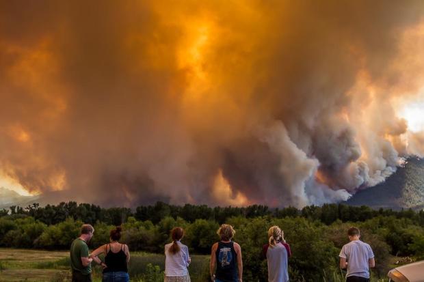
— BLM Oregon & Washington (@BLMOregon) May 5, 2017
With Georgia’s West Mims Fire now making continual headlines, photos of smoke plumes and falling ash are seemingly everywhere. That means this photo from a couple weeks ago is sure to make the rounds, too.
Published April 28 on InciWeb, the shot of a firefighter carrying a fawn to safety quickly got buried in a tide of photos showing the fire’s massive smoke plumes and stories about the front jumping containment lines. Ash fell on parts of downtown Jacksonville, Florida, over the weekend.
The West Mims Fire burns along Highway 94, near St. George, in this photo posted Monday on InciWeb.
According to the latest updates, the West Mims Fire has burned more than 140,000 acres. Another 7,000 acres has burned by Monday afternoon, and flame lengths up to 150 feet were reported.
Tuesday’s outlook was anything but promising.
“The fire will be fuel-driven and plume-dominated, meaning that when tall columns develop, they could abruptly collapse, sending downburst winds in all directions. Two columns could also develop at the same time,” officials said. “All this extreme fire behavior will create very dangerous conditions for firefighters.”
Above: Active wildfires are burning across Florida, as shown in this Florida Forest Service map depicting the situation as of Tuesday morning.
Dozens of wildfires are burning through Florida in what continues to be an unusually dry spring and an exceptionally busy start to fire season.
As of 7:30 a.m. Tuesday, 27 active fires larger than 100 acres were burning 27,417 acres across state jurisdiction. A total of 125 fires were affecting various regions of the state and burned more than 31,000 acres.
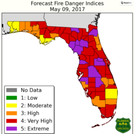
Florida’s forecast fire indices paint a bleak picture of the situation affecting the state in an unusually dry spring, as shown in this map from the Florida Department of Agriculture and Consumer Services.Burn bans are in place across a large swath of the state. Forecast fire danger indices for Tuesday called for “very high” or “extreme” fire danger in counties across the state.
“Florida wildfires have burned nearly four-and-a-half times more acreage under state jurisdiction than the same time last year,” said S. Kinley Tuten, a spokesperson for the Florida Department of Agriculture and Consumer Services, according to USA TODAY.
“Florida is in the middle of its worst wildfire season in years – with no end in sight,” said Commissioner of Agriculture Adam Putnam, CBS-Miama reported Monday.
While much of the United States has seen reprieve from drought conditions in recent months, the situation has worsened significantly across Florida since February, according to the U.S. Drought Monitor.
The drought situation in Florida has worsened significantly since February, according to the U.S. Drought Monitor.
Above: Chimney Tops 2 Fire November 27, 2016. Photo by Brett Bevill.
It’s been six months since a wildfire tore through the Tennessee mountain town of Gatlinburg, but political contests hinging on — among other things — an allegedly botched evacuation are heating up.
With more than 300 members on its closed Facebook group, Gatlinburg Fire Survivors has billed itself as a support group and a “safe place to tell your stories, vent your frustrations, and talk with others who went through the same thing.” But according to the Knoxville News Sentinel newspaper, the group in recent months has begun lobbying for accountability, getting only mixed results and leading some to challenge incumbent elected officials for their political seat.
While they say they support the first responders who scrambled to evacuate the town when the fire blew up Nov. 28, they — and many others — have criticized the lack of public information and communication breakdowns that hindered timely evacuations.
Issues surrounding the Gatlinburg evacuation have been widely reported, including by Wildfire Today. Essentially, city officials downplayed the threat early in the incident. Then, when hurricane-force winds tore through the region and fanned the flames, a “communication failure” caused by disabled communication services prevented the immediate issuance of a timely alert. Alternative sources of emergency communication — local media, for example — had only a marginal effect.
“Communications between the agencies was interrupted due to disabled phone, internet, and electrical services. Due to this communication failure, the emergency notification was not delivered as planned,” local, state and federal authorities wrote in a joint news release at the time. “Despite the catastrophic events that created barriers to communication, officials utilized all resources available to them at the time to warn the public of the impending threat.”
Fast-forward six months, questions and demands for accountability still abound, especially from survivors groups whose members say they suffer from PTSD as a result of the frantic evacuation.
“From the perspective of the Gatlinburg Wildfire Survivors, those who wield political power in Gatlinburg have labeled them as nothing more than a band of troublemakers. Appearing at public meetings has been fruitless,” the newspaper reported this week.
The divide hit a turning point of sorts over the weekend when a former city councilman held a town hall and outlined his reasoning for seeking a return to the five-person council. From the Knoxville News Sentinel:
He said he decided to seek a seat on council after seeing too many quality programs and events “fall by the wayside” under the existing leadership. He said he was responsible for securing the downtown flood warning system when he was on council and wants a more comprehensive system to deal with a multitude of potential emergencies.
Hawkins’ flood warning system, which consisted of a string of public address speakers, wasn’t activated Nov. 28 until the majority of Gatlinburg’s residents had already decided to evacuate.
The election is scheduled for May 16.
Fourteen people died as a result of the wildfires and nearly 2,500 structures were damaged or destroyed by flames that charred more than 17,000 acres in and around Great Smoky Mountain National Park.
On a related news front, Dolly Parton’s Dollywood Foundation gave $10,000 each to nearly 900 families displaced by deadly Tennessee wildfires to assist with the damages, the Associated Press reported. The singer said in a statement that the final distribution of checks was made this week to families in Sevier County.
“I’m as proud of being part of this, helping my people, as anything I’ve ever done in my life,”Parton said Monday, according to CNN. “And our next step is to continue to look at what’s ahead for everyone and our long-term recovery here.”
State Troopers hiked in to devastated areas in Gatlinburg, TN to rescue and escort out trapped residents. Tenn. Highway Patrol photo.
The 27-year-old German cave-dweller who ignited a deadly wildfire while burning used toilet paper on a Spanish island has been sentenced to three years in prison.
Scott Verdine Stumpf admitted last year to accidentally starting the August fire while burning used toilet paper — Spanish media outlets reported he had been living in a nearby cave for an extended period of time. In addition to prison, he was ordered to pay the equivalent of about $2 million U.S. dollars in restitution, local media outlets reported.
The wildfire blackened about 5,000 acres and forced hundreds of evacuations on La Palma, a landmass that is part of Spain’s Canary Islands. Francisco Jose Santana, a park ranger and married father of five, died during firefighting operations.
Tres años de cárcel para el hippy alemán del incendio forestal de La Palma https://t.co/ukwfZ96u98
The lightning-caused fire was reported on April 6 in the Okefenokee National Wildlife Refuge and has burned more than 135,000 acres. Crews on Saturday dealt with gusty winds and relative humidity levels around 18 percent, which drove the blaze past containment lines and fanned it farther east.
“The fire moved aggressively to the east and southeast against an enhanced air and ground attack today,” officials wrote in a Saturday night InciWeb update.
The fire and a blanket of falling ash on Saturday unnerved some residents near downtown Jacksonville, the Florida Times-Union reported.
Similar conditions were forecast for Sunday, and evacuation orders remained in place. Additional heavy air tankers were expected to arrive on Sunday from California and Montana to assist the approximately 535 personnel assigned to the incident.
The West Mims Fire remains just 12 percent contained. No injuries have been reported. Full containment isn’t expected until Nov. 1.
Above: The power pole hazard mitigation crew’s sawyer flush cuts a palo verde stump.
By Tom Story
“As Arizona’s largest utility, there are fire risks we have to manage,” said Wade Ward, Fire Mitigation Specialist for Arizona Public Service (APS). “The primary goal of fire mitigation is to prevent fire from ever happening. The second is to provide safe and reliable electricity to the communities APS serves. Just as important is the ability to provide for firefighter safety around our system in the event of a fire”, Mr. Ward continued. “With five thousand miles of transmission and twenty-eight thousand miles of distribution it is hard not to have our system affected by wildland fire. When this happens, APS’s priority is providing a safe environment for crews to work in”.
In Cave Creek, AZ; Wade Ward, Fire Mitigation Specialist for Arizona Public Service, sizes up a palo verde tree slated for removal as part of the APS Defensible Space Around Poles program.
Mr. Ward knows fire (he joined APS after his fire career at the Prescott Fire Department) and he has seen factors like drought, climate change and forest management set the stage for larger and more powerful wildland fires. “It is becoming more evident that due to extended drought over the past decade forest and vegetation ecosystems have been stressed from the lack of regular moisture compounded by shorter drier winters and longer warmer summers,” Mr. Ward said.
APS sends out inspectors to identify hazardous vegetation in violation of its safety and reliability clearance standards as well as violations of the National Fire Code and the Urban Wildland Interface Code (which state that a utility with equipment attached to the pole must clear all vegetation 10 feet in all directions including 10 feet from the ground). The area around the pole is cleared by work crews to create defensible space. “There are approximately 70 thousand poles within our system that we will have on a three year return cycle to maintain Defensible Space Around Poles (DSAP)” said Mr. Ward.
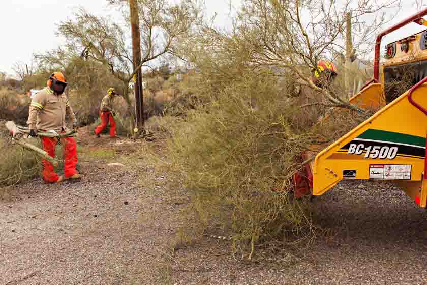
Other crew members cut up and feed the branches into a chipper.
The clearing is being done using manual methods (including chain saws, string trimmers and other hand tools) and where approved is followed by the application of herbicide in compliance with Environmental Protection Agency’s Integrated Vegetation Management practices. APS has prioritized the treatment of subject poles by utilizing data derived from a risk assessment done across the state. Mr. Ward continued; “It is a part of our core values at APS Forestry to manage vegetation and the environment by balancing benefits to create healthy forests and safe reliable energy”.
Mr. Ward finished his remarks noting, “In 2016 we created 110 acres of defensible space around the state of Arizona. One pole at a time”.
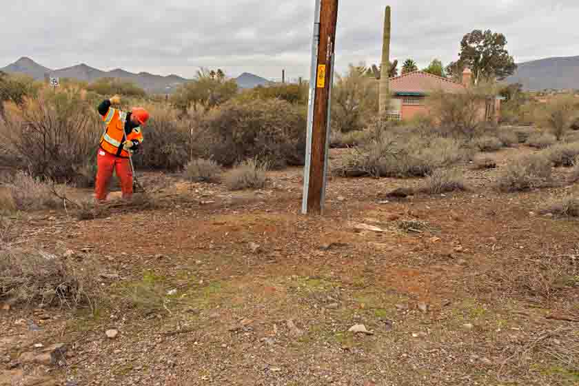
Putting the finishing touches on the cleanup around one of the Arizona Public Service power poles in Cave Creek, AZ.
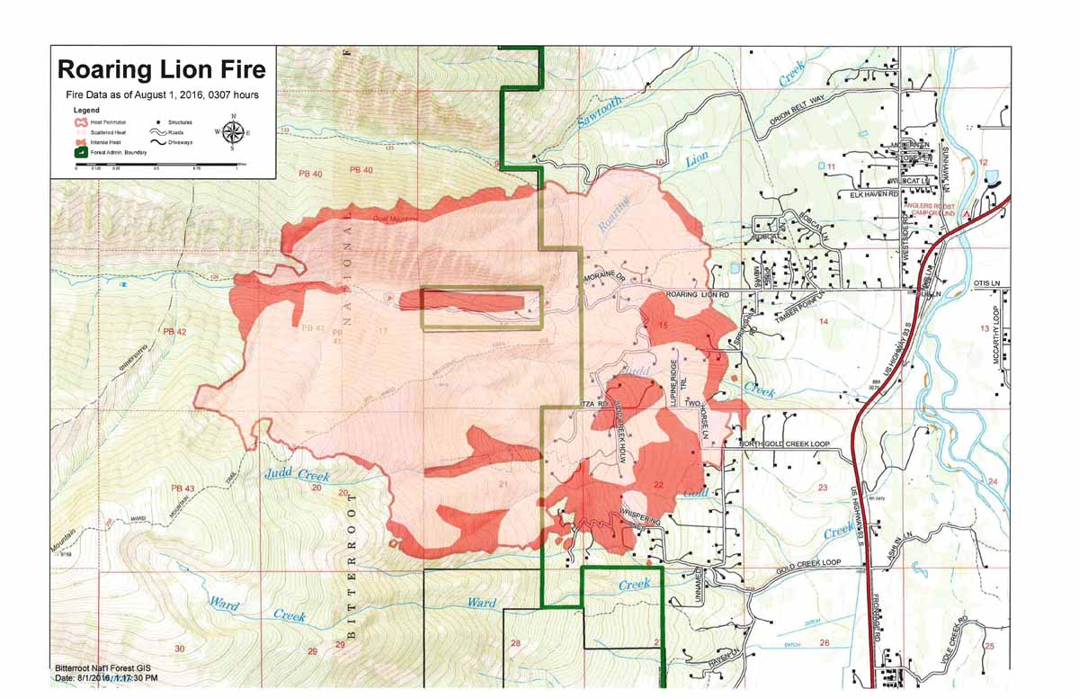
Above: Map of the Roaring Lion Fire. The red line was the perimeter at 3:07 a.m. MDT August 1. The red squares represent heat detected by a satellite at 2:31 p.m. MDT August 1, 2016, showing expansion of the fire to the northwest.
Click HERE to see the most current information on Wildfire Today about the Roaring Lion Fire.
(Update 5:52 p.m. MDT, August 1, 2016)
The Roaring Lion fire in the Bitterroot National Forest outside of Hamilton, Montana has destroyed several structures, although officials have yet to confirm how many, according to posts on InciWeb.
Five hundred homes remain under evacuation notice, and on Monday the fire had burned more than 3,000 acres.
Crews made some gains establishing a fireline on Sunday night, and were aided by 5 helicopters on Monday, according to InciWeb:
Last night, dozer and hand crews were able to punch in containment lines in a good portion of the East side of the fire. They were also able to put out multiple spot fires around residences.
The Type 1 team is expected to take over operations on Tuesday. The cause of the fire remains unknown.
Map of the Roaring Lion Fire at 3:07 a.m. MDT August 1, 2016. Click to enlarge.
Fanned by hot winds, the Roaring fire exploded in a massive plume of smoke on Sunday. Visit InciWeb to see more photos of the fire. Also, check out this time-lapse video of the fire (note: it will take about 20 seconds for images of the fire to start).
Roaring Lion fire, July 31, 2016
Meanwhile, the Copper King fire in the Lolo National Forest continues to burn, although it has not prompted any evacuations. On Sunday, the fire shut down Montana Highway 200, which officials reopened on Monday.
***
Two wildfires ignited in western Montana on Sunday, prompting evacuations and the shutdown of a U.S. highway.
A Type I incident management team has been ordered to respond to the Roaring Lion fire, which as of Sunday evening had already burned 2,000 acres outside of Hamilton.
A Type II team will be responding to the Copper King fire near Thompson Falls.
2 helicopters, one Single Engine Air Tanker and on Air Attack fixed-wing aircraft.
No structures threatened, and no evacuations, but the fire is very visible from Montana Highway 200.
As of Sunday night, the fire had burned 200 acres.
Strong gusty winds in the area.
Much of western Montana (including the two counties where the fires are, Sanders and Ravalli) has been abnormally dry or experiencing a moderate drought for the month of July, according to the U.S. Drought Monitor.
The National Weather Service has posted Red Flag Warnings and Fire Weather Watches for areas in California, Nevada, Utah, Idaho, Oregon and Montana.
The maps were current as of 7:45 a.m. MDT on Sunday. Red Flag Warnings can change throughout the day as the National Weather Service offices around the country update and revise their forecasts and maps. For the most current data visit this NWS site.
Drones shut down air operations over the Pioneer fire for 45 minutes on Sunday, while the fire continued to spread due to erratic weather conditions.
In a post on InciWeb, the incident management team said the drone incursion came at a critical time for firefighters.
Aviation operations once again stopped for 45 minutes during a critical period of fire suppression due to an unmanned aircraft incursion. IF YOU FLY WE CAN’T. PLEASE DO NOT FLY DRONES IN OR NEAR THE FIRE AREA.
Such a delay seems to have become common place on many fires, and last week incident management teams in California and Montana reported halting air operations due to drones in the area.
A spokeswoman for the National Interagency Fire Center has urged people not to flying drones into wildfire areas, and has said that people caught flying drones in wildfire zones could face criminal charges.
Meanwhile, the Pioneer fire has burned 27,271 acres and is 27 percent contained.
***
Crews on the 18,933-acre Pioneer fire north of Idaho City are facing a weekend of windy weather, which will likely fan the flames of a fire that has been burning since July 18.
Here’s the outlook for Sunday’s weather:
A passing cold front this evening may produce thunderstorms with gusty, erratic winds and increased fire behavior.Smoke will likely again be visible from great distances.
Crews are also grappling with poor access, steep terrain, dry forests and old mining sites, according to posts on InciWeb.
On Friday, heavy smoke from the fire drifted east and triggered warnings for unhealthy levels of smoke pollution. Smoke from the Pioneer fire was also drifting into Northern Colorado.