Preparedness Level 5 and the military

Posted on Categories UncategorizedTags

The national Preparedness Level increased to Level 5 today, the highest level. The criteria for this includes

Geographic Areas are experiencing major incidents which have the potential to exhaust all agency fire resources. 80 percent of Type 1 and 2 IMTs and crews are committed, as well as the majority of other national resources.

This means national fire leaders may assess the need for seeking international or military assistance. The National Multiagency Coordinating (MAC) Group gave the geographic MAC groups quotas for the number of Military Crew Advisors (MCAD) and Military Strike Team Leaders (STLM) they they must send to Boise by July 3. They are requesting a total of 26 MCADs and 6 STLMs for 30-33 day assignments. So, one would have to assume they are activating some military hand crews.


N.C.– Eight firefighters struck by lightning

Posted on Categories Uncategorized

From WCNC.com–

LENOIR, N.C. — Five firefighters are still in a hospital after being struck by lighting while battling a forest fire.

A total of eight firefighters with the North Carolina Forest Service were trying to contain the blaze Saturday, which was sparked by lighting the day before. The strike happened at 4:48 p.m.

Forestry officials believe the lightning bolt hit a tree; the energy radiated underground, where the firefighters were taking a break. They say the sky was clear blue at the time.

“It was totally unexpected. We monitor and try and keep up with the weather and there was no prediction, no threat of imminent danger. Had there been, we would have pulled those firefighters off the mountain,” said Rusty Dellinger, a ranger with the North Carolina Forest Service.

The area was so remote that it took crews an hour and a half to get them down from the mountain and into an ambulance. None of the injuries appear to be life-threatening.

“Most of them were complaining of pain in the lower extremities. Some were complaining of headaches. Some did receive some minor burns,” said Dellinger.

Initially, all eight firefighters were hospitalized. Doctors are treating the remaining five firefighters at Caldwell Memorial Hospital. Four of the eight are inmates who assist the forest service though a work release program. The Occupational Safety and Health Administration is investigating what happened.


California: Basin and Indians fires map and update

Posted on Categories Uncategorized

The Indians fire is looking very good. The firing on the north side along the Arroyo Seco drainage is complete and they are predicting official containment on July 3.

————-

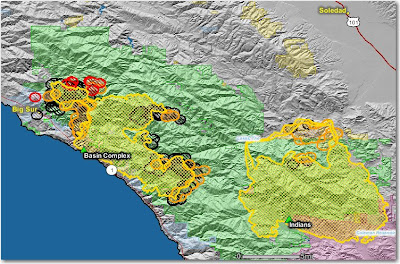
Crews on the Basin Complex near Big Sur are constructing indirect firelines up to 6 miles out ahead of the fire, using some of the same tactics that were successful on the nearby Indians fire, indirect line and then burning the fuels between the line and the main fire.

On the south side, dozers and hot shot crews are constructing and firing out a line from the North Coast Ridge Trail, south to the coast near Big Black Rock south of Esalen.

The fire on the north side is burning around Big Sur, while crews, dozers, and engines are working on containment lines that are mostly indirect, and are firing out behind houses as needed.

The map below shows heat, in red, orange, and black, detected by satellites last night, with the red areas being the most recently burned. The yellow lines are the perimeters uploaded by the incident management teams. Click on the map to see a larger version.

California: Piute fire

The Piute fire, about 6 miles south of Lake Isabella, was very active again yesterday, growing by 4,840 acres. This fire has a lot of potential to be a problem. It is now 7,040 acres and 6% contained.

South Zone reported this at 1800 yesterday:

The West side of the fire is unsafe for direct attack. The north end of the fire is running towards numerous camping areas and the communities and structures in Lake Isabella, Bodfish, Liebel Ranch, Valley View Sub-division, French Meadow, Historic Rocky Point Mining area, Red Mountain, and Claraville. Road closures were initiated today.

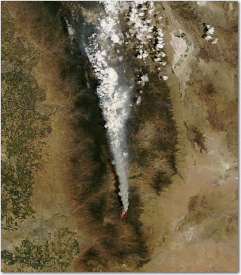
The map below shows heat in red and black detected by satellites last night, with the red areas being the most recently burned. Click on the map to see a larger version.

California: Piute fire

The Piute fire on the Sequoia NF started yesterday and is moving out. HERE is a link to an almost-live web cam view of the fire.

Piute (CA-SQF-1356) 2,560 acres and 4% contained. Protection of the USFS Repeater Site, the Buston Mill, historic town sites and critical habitat areas are a priority. Closure was ordered for area campgrounds, resulting in the evacuation of campers. Road closures include Piute Mountain Rd., Saddle springs Rd. and Cold Springs Rd. Evacuations were put in place for residences and visitors in Brown’s Meadow and French Meadow. An evacuation advisory notice was issued to residents and visitors of the Claraville Town site. An Evacuation Center was opened in Lake Isabella at the VFW/Senior Citizens’s Center.