Fuel, fire and smoke: Evolving to meet our climate challenge

Wildfires have become an increasing challenge to humanity, the ecosystem, and the atmosphere we depend on. Responding to larger and more destructive wildfires and protecting against their climate impacts is challenging; understanding fire behavior and our responses is critical.

The 7th International Fire Behaviour and Fuels Conference is a forum in which fire management experience is documented, current work is showcased, and emerging research is shared as we together develop solutions to these challenges.

This conference on three continents brings together countries in three areas of the world to develop fire policies at national, regional– to learn from others how they address fire risks and build resilience. The conference unites policymakers, scientists, managers, and indigenous land stewards for a shared purpose in  living with fire.


The 7th International Fire Behaviour and Fuels Conference hosts events on three continents, highlighting a range of experience from different countries to develop fire management policies in facing risk and building resilience.

The conference will bring together policymakers, scientists, fire managers, and Indigenous land stewards, and more for a shared purpose of creating a future where we can live with fire. Join us for an authentic conversation on managing fires and creating a sustainable future.

Presenters and speakers this year include Dr. Lori Moore-Merrell, Dr. Dean Yibarbuk, Dr. Lachlan McCaw, Prof. Nerilie Abram, Prof. Sarah Legge, Dr. Dan Pronk, Katie Lighthall, Dr. Mark Finney, Dr. Mark Parrington, Dr. Joseph Wilkins, Edward Alexander,and Dr. Conceicao Colaco. All conference registrants at any of the three locations will receive access to recordings of each presentation.

Workshops: Our interactive workshops are educational and feature a range of topics to choose from. You can learn new skills and connect with experts in their fields.

Field Tours: Each location has scheduled a collection of field trip opportunities. Field tours provide hands-on learning options  from exploring nature to sharing history and culture. Select your trip when you register.

Exhibitors: Our exhibition hosts a range of displays and demos. You will learn more about the latest products and services in fire science and management. We look forward to seeing you there!

BOISE conference
TRALEE conference
CANBERRA conference


The International Association of Wildland Fire (IAWF) is a non-profit, 501(c)(3) professional association committed to a non-partisan approach for uniting the global wildland fire community. We were formed in 1990 as a global professional membership association. For 30 years IAWF has grown from a fledgling organization to a global member-focused association spanning 26+ countries. The IAWF was formed to promote a better understanding of wildland fire and built on the belief that an understanding of this dynamic natural force is vital for natural resource management, protecting the health, safety, and welfare of people including firefighters and the public, and for harmonious interactions between people and their environment. IAWF is dedicated to communicating with the entire wildland fire community and providing a global linkage for people with shared interest in wildland fire and all of the associated topics of this multifaceted community. To accomplish these goals, we convene and create networks across sectors, fields, and disciplines to connect the wildfire community through multiple platforms, through which we communicate — including conferences, our website, the premier academic journal in our field (International Journal of Wildland Fire), a popular-oriented magazine (Wildfire) and via social media outlets.

Oregon IMTs and firefighters out for ice storm recovery

Western Oregon’s recent ice storm cleanup, after one of the worst winter storms in history, is now in the mop-up stage, and firefighters with the Oregon Department of Forestry have teamed up with the City of Springfield to help. For most of a week now, they’ve worked in the Thurston area of Springfield east of Eugene, clearing downed trees and sidewalks. A team of 14 started by clearing students’ paths to area schools.

“We noticed that right after the ice storm, they were using the streets to walk because they weren’t able to access the sidewalk,” ODF forester Kolten Vickers told Albert James with KEZI News in Eugene . “So we started around schools, and now we’re branching off into other parts of neighborhoods.”

Vickers has been with ODF for five years, but this is his first time cleaning up after a winter storm. “Primarily I assist with fires during the summers,” he said. “But with ODF having incident management teams — it’s all incidents. So storm recovery falls under that response.”

Local resident Patty Gori regularly walks the neighborhood with her dogs and was grateful to see the clearing work. “It was a mess,” she said. “But now, it’s amazing. They got so much cleaned up in the last couple of days, I just can’t even believe it.”

Who ya gonna call? Firefighters. Besides clearing streets and chainsaw duty, ODF sent an IMT to coordinate a unified response to the storm.

“You don’t see what’s going on behind the scenes,” said Joe Hessel, from a longtime firefighting family in eastern Oregon.  “You see firefighters digging a fireline or public works crews working on city streets. At some point, somebody’s trying to organize that chaotic potential into something that makes sense. That’s what we’re here helping the city do.” Hessel serves as a deputy incident commander for this post-storm incident, but he’s usually an incident commander with a state team. He said the storm response effort was started and led by Lane County and the City of Springfield, but on January 25 they transferred command over to the city, with the IMT from ODF still assisting.

“In large part, the city staff and departments are doing the work, just like when we were with Lane County,” Hessel said. “We’re helping at the highest level to coordinate and put a plan together to ensure that the right work is getting done at the right place at the right time.”

“We do train for incidents outside of wildfire,” he explained. “The ICS system we use on wildfires carries right across to pretty much any other incident. We’ve been to Florida and helped the State of Florida in hurricane response. We’re prepared in the event that there’s an earthquake or a tsunami here. Last year one of our teams, a short team like we have here, went to a county and helped out with a cyber attack and planning for how to manage and deal with that.”

“ODF is great, they do this type of work for a living in fire management, so they have a lot of experience in incident management,” said Ben Gibson, operations maintenance manager with the City of Springfield. “They’ve been a great resource to our emergency operations center staff in helping us move forward smoothly.”

ODF truck
Oregon Department of Forestry logo on a truck door.

Hessel said both his team and the local crews have learned a lot from each other, and he hopes the information shared between the groups can go a long way in responding to future events. “That transference of skills and knowledge to each other will benefit pretty much either entity,” he said. “And then we’ll actually develop some products we’ll leave behind — some written documents, like a debris removal plan that could be used next time, or a contact list with names on it.”

Eugene and Springfield and the surrounding area endured a record-breaking winter storm with snow and ice and rain and high winds. The storm caused widespread power outages and severely damaged at least 60 percent of the trees at the Mt. Pisgah Arboretum. The storm took out powerlines at the arboretum and necessitated a safety closure, according the a report by Oregon Public Broadcasting. Brad Van Appel, longtime director at Mt. Pisgah, said there was about an inch of ice on the trees and it was more than most of them could take.

“We have 209 acres, much of it full of trees,” he said. “I think nearly every tree took some damage.” For those wanting to help, the arboretum and its sister organization Friends of Buford Park are looking for volunteers, and they can sign up online.

Also of note, ODF is looking for a Wildland Fire Supervisor to manage the fire program down in Klamath Falls. This is a permanent benefited position. $4,918 – $7,244 monthly depending on experience. Recruitment closes January 31. 

Details: WILDLAND FIRE SUPERVISOR APPLICATION

Yet another utility lawsuit over 2020 fires

A group of four law firms in Oregon and California has sued the Eugene Water and Electric Board (EWEB), Lane Electric, and Bonneville Power Administration (BPA) for their roles in the  Holiday Farm Fire east of Eugene, Oregon — part of the Labor Day fire siege of 2020.

In the approximately 200-page lawsuit, attorneys claim the three utility companies neglected to prepare electrical operations and equipment before the fire burned across 173,400 acres and destroyed more than 700 structures. The Holiday Farm Fire burned on the Willamette National Forest, BLM lands, and private property within Oregon Department of Forestry protection units. The lawsuit was filed on behalf of 238 victims who lost homes and property in the fire; the suit asks for $232 million.

As of September 10, 2020, the Holiday Farm Fire — named for a local tourist attraction called the Holiday Farm that included a wedding venue, RV resort, and year-round holiday Christmas gift shop — had burned over 144,600 acres about 14 miles up the McKenzie River from Eugene. Fire behavior and weather conditions were treacherous and kept firefighters from entering many areas, but they did protect some homes by burning out around them.

Jennifer Singh of KEZI in Eugene reported that the case was originally filed with Lane County Circuit Court against Lane Electric and EWEB — for neglecting to safeguard space around their powerlines from unstable trees and other hazards, but new records have revealed evidence that BPA also played a role in the disaster.

The lawsuit should come as no surprise to anyone — except maybe BPA — because local residents and fire officials were discussing the likelihood that the Holiday Farm Fire was ignited by powerlines while it was still in the initial attack phase.

Holiday Farm Fire
Holiday Farm Fire — Oregon Daily Emerald photo

“It wasn’t until the end of last year that we discovered new evidence that pointed to Bonneville Power Administration sparking a second fire,” said Alex Robertson, one of the four attorneys for the plaintiffs. He said that second fire merged with the Holiday Farm Fire. BPA provided power to EWEB and Lane Electric, and failed to power down its lines in a public safety shutoff. On Labor Day a danger tree fell onto a BPA line on Highway 126 and ignited another fire about 4 miles away.

This is the evidence that caused the law firms to bring BPA on as a co-defendant for the suit filed as a federal case — BPA is a federal agency, so unlike previous cases in county circuit court, this suit will be heard in federal court. The earlier case filed against Lane Electric and EWEB was dismissed to combine with the suit against the BPA.

[MORE DETAILS HERE]

Robertson said that on the same day the new lawsuit was filed, January 16, another suit was filed by 60 insurance companies seeking reimbursement of claims already paid to homeowners.

The Forest Service and Inciweb have wiped most of the records of the fire from their websites, but a BAER summary [PDF] of the Holiday Farm Fire is still available online.

Another $85 million on PacifiCorp’s liability tab

PacifiCorp will pay another $85 million to nine more victims of the 2020 Labor Day fires, after a jury in Multnomah County on Tuesday recorded the latest verdict in a series of lawsuits that means billions of dollars in liability costs for the Portland-based utility company, according to an AP report.

“PacifiCorp has settled and will continue to settle all reasonable claims for actual damages under Oregon law,” the utility said. The western Oregon fires were among the worst in the state’s history, killing nine people, burning 1.2 million acres, and destroying upward of 5,000 homes and other structures. Though the extreme fires were not unprecedented, the Labor Day fires burned more of the Oregon Cascades than had burned in the previous 36 years combined.

one of the exhibits at PacifiCorp trial
From one of the exhibits at trial establishing PacifiCorp’s liability

A jury in June found PacifiCorp liable for negligence in its failure to de-energize powerlines for its 600,000 customers — after the utility was warned by fire officials and emergency managers that its powerlines had started multiple fires and that there was an emergency need to cut power in at-risk areas because of the extreme fire danger.

Plaintiffs were awarded $71 million in that case.

PacifiCorp agreed last month to pay $299 million to settle a lawsuit by 463 plaintiffs who lost homes and other property in southern Oregon wildfires in September 2020. That jury awarded around $90 million to 17 homeowners. The award on Tuesday was the first of cases brought by plaintiffs in the broader class-action suit. More trials are set for February and April.

2020 Labor Day fires in western Oregon
Labor Day weekend fires in 2020 in western Oregon

Risk assessment in the West

In 2018 Rick Stratton, a USFS fire planning program manager for the R6 Regional Office in Portland and Pyrologix provided a Quantitative Wildland Fire Risk Assessment for communities most at risk in the Pacific Northwest — and he listed the top 25.

Six years later he compared that assessment with what had actually happened, and 18 of the 25 communities had recorded significant/catastrophic wildland fires. His assessment illustrates a rapidly evolving wildland fire environment, in which entire communities are at risk. Below are some of Stratton’s slides.

How do interface disasters occur? Jack Cohen‘s work on wildland/urban interface fires demonstrated that in the beginning, the set-up for a disaster fire includes extreme fire conditions — much of which has been widespread across the West over the last decade or more. Abundant dry fuels, fire-friendly weather such as drought, extreme heat, low humidities, and high winds all contribute to a landscape ready for a fire disaster.

To that setting is added both wildland fire (with rapid spread) and urban fire — which includes multiple simultaneous ignitions and residential areas in which fire spreads from house to house to house, complicated by non-vegetation burning of cars, fences, decks, garages, stacked firewood, and often-hazardous materials typically found on interface industrial properties, workshops and garden sheds, or even gas stations. Frightened residents trying to evacuate on limited access routes, often with uncoordinated communications and plans, simply multiply the crisis.

How interface disasters occur
How interface disasters occur — Jack Cohen

Pacific Northwest risk map: Clearly illustrated here is the band of interface-populated communities that runs down from the northeast corner of Washington to the southwest corner of Oregon — adjacent to and in forested areas.

Pacific Northwest risk map

Unlike the larger metro areas (Seattle, Portland), these communities are surrounded by rural and forested land, and consist mainly of smaller communities with limited suppression resources, and sometimes challenging water supply or prevention resources.

charted risk exposure

… and … 6 years later:

Interface fires in Northwest communities at risk fir catastrophic interface fire

Only a few of those ranked community exposure locations were NOT burned by a large interface fire. Ellensburg, Washington, suffered multiple fires, as did Spokane, Grants Pass, and Chelan.


Joe Stutler
Joe Stutler

A Western Region Co-Chair for the Wildland Fire Cohesive Strategy, Joe Stutler worked 35 years with the U.S. Forest Service. Since retiring, he’s worked for Northtree Fire International and as senior forester with Deschutes County for 8 years. He has worked as a hotshot, smokejumper, district and forest FMO, district  ranger, law enforcement officer, and regional fire operations specialist  for both R5 and R6. He put in 33 years as Type I and II Incident Commander and 6 years on National Area Command Teams. He has managed all-hazard and law enforcement assignments across the country and currently fills Command and General  positions on Type 1 IMTs and Area Command teams.

Here are a few of Joe Stutler’s thoughts on these risk assessments: I am wide-eyed at the accuracy of Rick Stratton’s predictions and the big fires that followed in 2018-2022.  Most of these high-ranking landscapes were in Fire Regimes 1 & 2, and those that have been burned by large intense wildfire have now reset to Condition Class 1.  But what about those that remain in Condition Class 3, like here in central Oregon and other places in the U.S.?

The wildland fire environment is rapidly changing, and this slide deck shows that to be true. The question is, what can we in the business of helping people understand it actually do about it?  The answer lies in  collectively and strategically communicating these issues.

From my world, I immediately think about how the Cohesive Strategy has been affirmed by the Wildland Fire Leadership Council (WFLC) AND the President’s Wildfire Mitigation and Management Commission as THE strategic framework that can be applied at and by every level (federal, tribal, state, local, and NGOs) to address wildland fire challenges to make substantial, meaningful progress toward landscape resiliency, community resiliency, and fire adaptation — and a safer, more effective, risk-based wildfire response.

The part that stands out to me (apart from the obvious needs to increase the pace and scale of landscape resiliency treatments and address the different response approaches and needs of the “urban firestorm” probability) is the need for doubling down toward the CS goal of fire-adapted communities.  The goal is described as “communities that are as prepared as possible to receive, respond to, and recover from wildland fire.”

This elevates the responsibility for preparedness to more than just our response as land management agencies and organizations, but to us as residents, responders, planners, emergency managers, governments, businesses, news outlets, and other organizations in communities.  We each have a responsibility to think about what RECEIVING FIRE, RESPONDING TO FIRE, and RECOVERING FROM FIRE means to each of these community affiliates — and start heading down the path of preparation. These are ripe for defining within communities and providing suggestions for action.  The definitions and suggestions will be different in every community, and we can organize and assist with these conversations, suggestions, and actionable solutions.

Many best practices have been applied and are underway across the West by all these entities, but the devastating destruction of entire communities over the last decade tells us that there is still much to do at the community level to prepare for wildland fire.  Even today, many communities across the West — and for that matter east of the Mississippi — still do not realize that not only is the wildfire risk high, but there is also high likelihood of loss given the rapidly changing wildland fire environment.  A changing climate (hotter, drier, windier conditions) alone is making “urban firestorms” a more prevalent reality, even in the East and South.

It’s clear that we need efforts toward all three goals of the Cohesive Strategy to make a difference and change the outcomes of wildland fire.  Our vision is a good place to start — “To safely and effectively extinguish fire, when needed; use fire where allowable; manage our natural resources; and collectively, learn to live with wildland fire.” If we as individuals are truly learning to live with wildland fire, we must consider what that looks like in the face of the research and outcomes that Rick Stratton shares and then apply the Cohesive Strategy for better fire outcomes.

Ignoring our responsibility to learn to live with wildland fire is a choice. And we now know what the outcomes of that are.

Smoke gets in your eyes

Carsten Warneke with NOAA flies through wildfire columns in a converted DC-8. On purpose. As reported by Devin Farmiloe in SLATE Magazine, Warneke is a research physicist with the National Oceanic and Atmospheric Administration who investigates wildfires and their effects on air quality. He collects for analysis air samples over a live wildfire and its smoke columns, including in a DC-8 over the 2019 Williams Flats Fire, which burned more than 5,000 acres in northeastern Washington.

“We knew what was coming when we saw the monster of a plume,” remembers Warneke. “It was so much bigger than anything else we had seen. But we are scientists, so we were geeking out. The excitement for measuring such a large plume trumped everything.”

He said they decided to measure as close to the fire as possible to get emissions, and then follow the plume downwind to see how those emissions changed. The plume was 20,000 to 25,000 feet, so they decided to fly it at about 1,000 feet below the top of the plume. “You can’t fly directly over the fire, because the updraft is so large it would be extremely dangerous,” he explained. “In a fire that size, there are pieces of branches and stuff going a couple thousand feet into the air, so we had to go higher up.”

There is about three years of planning that goes into these missions, and one of the last stages is to decide where the emissions measurement instruments are going to be secured in the aircraft, what its weight is, and whether the aircraft is able to carry out the campaign. An aircraft over a fire, Warneke says, “is about the worst environment you want to put your high-performing atmospheric instruments in. These instruments are like the Formula One race cars of atmospheric chemistry.”

Each one weighs a few hundred pounds and is about the size of a washer/dryer combo. “They have a lot going on,” explains Warneke, “a  monitor, weird pumps, vacuum fittings, and so on. The window next to each of these instruments has been replaced with an aluminum plate that has a little wing on the outside of it, to be more aerodynamic and reduce drag. Within that little wing, we stick the tube to collect air samples. There is a first-class passenger seat next to each instrument for the scientist in charge of making it run properly.”

Warneke remembers in particular one FIREX flight through smoke in Montana, over  a grass fire that had already been contained. Smoke was still hanging on top, but the air was clear beneath it.

“There was still a little residual heat,” he says, “and we flew through it at maybe 10,000 feet. As we went through the smoke, the updraft was still so strong that the plane jumped up 100 meters within a couple of seconds. At that moment, I was standing in the cabin, and it bumped me up and I levitated for a second before we bumped down on the other side. At that moment, everyone went silent over the headsets, then a minute later the pilot said, ‘If we do this again, let’s make sure we have seatbelt signs on.'”

“We did the FIREX campaign in 2019, which was one of the lowest fire years we have had in a decade now, but wildfires have been recurring for years and years, and the impacts will stay with us for decades to come,” says Warneke. “Researching wildfires will continue to be important to our lab, especially since our largest air-quality-exceedance days happen with wildfire smoke.”


The Fire Influence on Regional to Global Environments and Air Quality (FIREX-AQ) campaign was a NOAA/NASA interagency intensive study of North American fires to understand the integrated impact of fire emissions on the tropospheric chemistry and composition and to assess the satellite’s capability for detecting fires and estimating fire emissions.

The overarching goal of FIREX-AQ was to provide measurements of trace gas and aerosol emissions for wildfires and prescribed fires in great detail, relate them to fuel and fire conditions at the point of emission, characterize the conditions relating to plume rise, and follow plumes downwind to understand chemical transformation and air quality impacts.

NASA DC8 over the Brooks Range 01 Photographer: D. Lack
NASA DC8 over the Brooks Range 01 Photo by D. Lack

Completed during summer 2019, FIREX-AQ combined instrumented aircraft, satellites, and ground-based instrumentation. Detailed fire plume sampling was carried out by the NASA DC-8 aircraft, which had a comprehensive instrument payload capable of measuring over 200 trace gas species, as well as aerosol microphysical, optical, and chemical properties.

The DC-8 completed 23 science flights, including 15 flights from Boise and 8 flights from Salina, Kansas. NASA’s ER-2 completed 11 flights, partially in support of the FIREX-AQ effort. The ER-2 payload was made up of 8 satellite analog instruments and provided critical fire information, including fire temperature, fire plume heights, and vegetation/soil albedo information. NOAA provided the NOAA-CHEM Twin Otter and the NOAA-MET Twin Otter aircraft to measure chemical processing in the lofted plumes of Western wildfires.

NOAA Twin Otter
One of NOAA’s Twin Otters

The NOAA-CHEM Twin Otter focused on nighttime plume chemistry, from which data is archived at the NASA Atmospheric Science Data Center (ASDC). The NOAA-MET Twin Otter collected measurements of air movements at fire boundaries with the goal of understanding the local weather impacts of fires and the movement patterns of fires. Additionally, a ground-based station in McCall and several mobile laboratories provided in-situ measurements of aerosol microphysical and optical properties, aerosol chemical compositions, and trace gas species.

For more information on the Airborne Multi-angle SpectroPolarimetric Imager (AirMSPI) data collected during FIREX-AQ, see: AirMSPI FIREX-AQ Terrain-Projected Georegistered Radiance Product.

FEMA director resigns after fire fund failure

Longtime federal agency official Angela Gladwell has “overseen” the $4 billion compensation fund that was supposed to pay victims of a disastrous 2022 New Mexico wildfire accidentally started by the Forest Service. Her resignation follows resounding criticism of FEMA’s handling of payments that were funded and due residents for damages caused by the Hermit’s Peak / Calf Canyon Fire, which destroyed over 400 homes and racked up literally billions of dollars in suppression costs and damages.

Angela Gladwell’s actually being “reassigned,” because the Federal Emergency Management Agency is “restructuring” its disaster response in New Mexico — in part because of loud and long criticism of its handling of disaster aid and damage payments — which Source New Mexico and ProPublica have followed for the past year.

A year after the fire, the FEMA claims office had paid less than 1 percent of its total funding allocated.

In a news release announcing Gladwell’s departure, Deborah Martinez with the claims office said she “successfully built a compensation program from the ground, assembling a team of locally hired staff with knowledge of New Mexico and the communities affected by the wildfires.” Martinez said Gladwell will now “transition to a new role” as FEMA consolidates recovery programs in the state. She would not, however, answer questions about what that “consolidation” might entail.

Quebec arsonist pleads guilty

A Quebec man who posted conspiracy theories online — including that forest fires were being deliberately set by the government — has pleaded guilty to igniting fires that forced hundreds from their homes during last summer’s brutal Canadian fire season.

Brian Paré on facebook

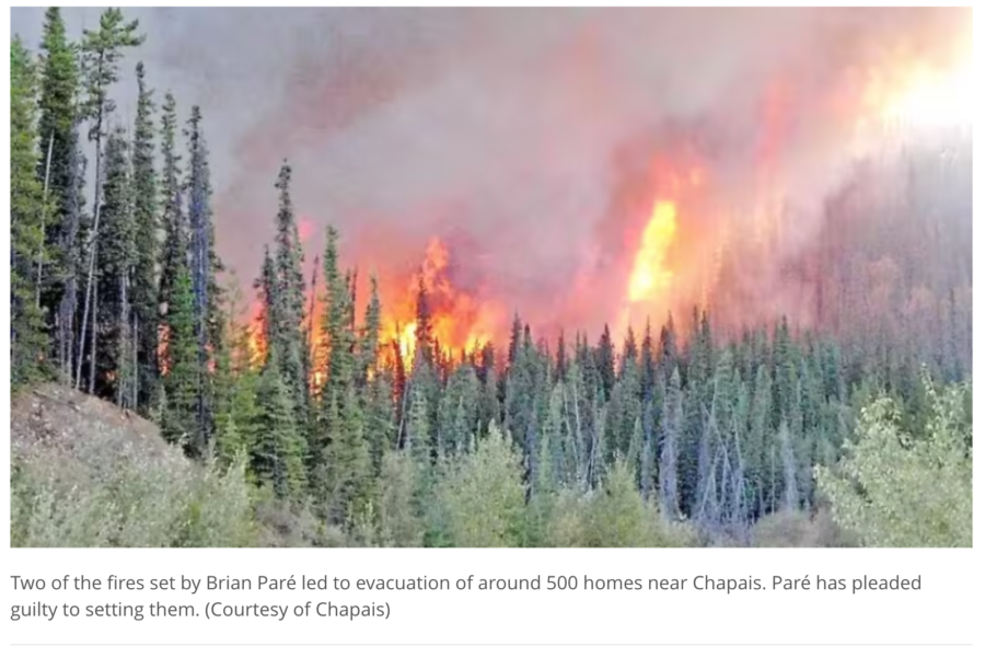
On Monday Brian Paré, 38, pleaded guilty in Quebec to 13 counts of arson and one count of arson with disregard for human life. The CBC News out of Montreal reported that prosecutor Marie-Philippe Charron said two of the 14 fires he lit caused the evacuation of 500 homes in Chapais, a community about 425 kilometres northwest of Quebec City.

“On May 31 at 8:30 p.m., the town of Chapais issued a mandatory evacuation order due to the raging fires,” Charron said, “in particular the fire at Lake Cavan as well as the airport fire, two fires that are included in the charges and were caused by the accused.”

Residents of Chapais could not return home for three days.

Chapais fire, Quebec

The Guardian reported that fighting that fire drew resources away from some of the nearly 700 fires in the province last summer. Most of those fires were ignited by lightning. The largest fire set by Paré, the Lake Cavan Fire,  was one of the first in a series of five that he set between May 31 and June 1 just days after the provincial government had issued a ban on open fires because of dry weather conditions and fire danger.

Provincial police and first responders noted that some of the fires had no possible natural cause, and evidence indicated that some of the fires were  intentionally set. Police first spoke to Paré on June 2; he had been seen in the area near a fire’s ignition point, and was considered a witness. Though he denied starting the fires, Charron said Paré demonstrated interest in fires in an interview, which led police to suspect him.

Brian Paré conspiracy post

And that month he began posting on facebook about Quebec’s record-breaking season; among his posts were claims that the fires were intentionally set by the government to trick people into believing in climate change. Police set a tracking device on Paré’s vehicle, and it tracked him at locations where other fires were ignited.

conspiracy posts on facebook by Brian Paré

Brian Paré on facebook

Paré was arrested on September 7 and admitted to starting nine of the fires. He said he was doing tests to learn whether the forest was really dry or not, according to the prosecutor.

Fatal SEAT crash yesterday in Chile

The Ministry of Agriculture in Chile has confirmed that a pilot working for the National Forestry Corporation (CONAF) has died following a plane crash near Panguilemo Airport (TLX). According to aerotime.aero, the Ayres Turbo Thrush aircraft was flying fire control work at around 4:30 pm local time.

CONAF reported that the accident occurred in the commune of Talca and resulted in the death of Mr. Fernando Solans, of Spanish nationality, pilot of the Turbo Trush operated by Air Andes.

Xinhuanet reported that the crash on a highway in south-central Chile also  injured three people in a car.

A witness’s video indicated that the plane’s wing appeared to clip wires hanging between two utility poles before the SEAT crashed onto Route 5 South in Talca, Maule Region.

 ~ Thanks and a tip of the hardhat to Tim for the news note.