Yet another utility lawsuit over 2020 fires

A group of four law firms in Oregon and California has sued the Eugene Water and Electric Board (EWEB), Lane Electric, and Bonneville Power Administration (BPA) for their roles in the  Holiday Farm Fire east of Eugene, Oregon — part of the Labor Day fire siege of 2020.

September 2020 Oregon fires

In the approximately 200-page lawsuit, attorneys claim the three utility companies neglected to prepare electrical operations and equipment before the fire burned across 173,400 acres and destroyed more than 700 structures. The Holiday Farm Fire burned on the Willamette National Forest, BLM lands, and private property within Oregon Department of Forestry protection units. The lawsuit was filed on behalf of 238 victims who lost homes and property in the fire; the suit asks for $232 million.

As of September 10, 2020, the Holiday Farm Fire — named for a local tourist attraction called the Holiday Farm that included a wedding venue, RV resort, and year-round holiday Christmas gift shop — had burned over 144,600 acres about 14 miles up the McKenzie River from Eugene. Fire behavior and weather conditions were treacherous and kept firefighters from entering many areas, but they did protect some homes by burning out around them.

Jennifer Singh of KEZI in Eugene reported that the case was originally filed with Lane County Circuit Court against Lane Electric and EWEB — for neglecting to safeguard space around their powerlines from unstable trees and other hazards, but new records have revealed evidence that BPA also played a role in the disaster.

The lawsuit should come as no surprise to anyone — except maybe BPA — because local residents and fire officials were discussing the likelihood that the Holiday Farm Fire was ignited by powerlines while it was still in the initial attack phase.

Holiday Farm Fire
Holiday Farm Fire — Oregon Daily Emerald photo

“It wasn’t until the end of last year that we discovered new evidence that pointed to Bonneville Power Administration sparking a second fire,” said Alex Robertson, one of the four attorneys for the plaintiffs. He said that second fire merged with the Holiday Farm Fire. BPA provided power to EWEB and Lane Electric, and failed to power down its lines in a public safety shutoff. On Labor Day a danger tree fell onto a BPA line on Highway 126 and ignited another fire about 4 miles away.

This is the evidence that caused the law firms to bring BPA on as a co-defendant for the suit filed as a federal case — BPA is a federal agency, so unlike previous cases in county circuit court, this suit will be heard in federal court. The earlier case filed against Lane Electric and EWEB was dismissed to combine with the suit against the BPA.

[MORE DETAILS HERE]

Robertson said that on the same day the new lawsuit was filed, January 16, another suit was filed by 60 insurance companies seeking reimbursement of claims already paid to homeowners.

The Forest Service and Inciweb have wiped most of the records of the fire from their websites, but a BAER summary [PDF] of the Holiday Farm Fire is still available online.

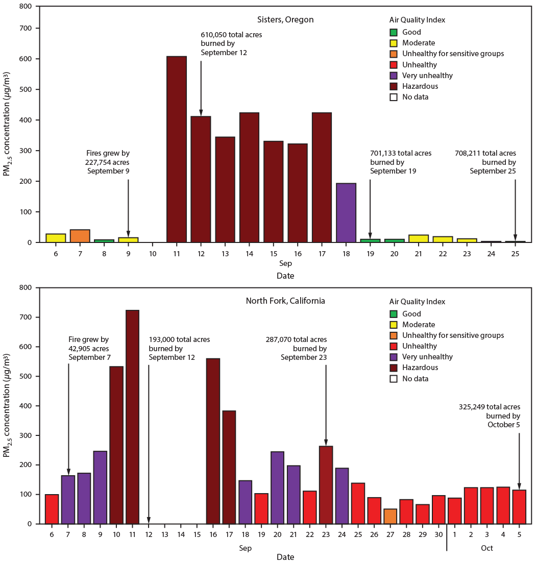
Study found hazardous air quality conditions at fire camps in Oregon and California

Smoke exposure levels at the Creek Fire ranged from hazardous to unhealthy for 30 days

(From Bill: Wildland firefighters and people who live in areas where long-term fires are common, such as Northern California and the Northwest, know that smoke can persist for days or weeks and can cause or aggravate respiratory and other medical issues. But knowing it exists and having peer reviewed quantifiable data proving it is hazardous to health, are two different things. Science like this could lead to changes that may benefit firefighters and the general public.)


In September and October the Centers for Disease Control and Prevention (CDC) deployed two staff members to serve as air resource advisors at wildfires in Oregon and California.

Air resource advisors were fully integrated into the wildfire incident management teams to provide insights into understanding and predicting smoke exposure levels. The individuals interacted with stakeholders, including air quality regulators, fire personnel, public health practitioners, and community residents. A primary aspect of this engagement was to forecast smoke levels for areas immediately affected by fires and generate a daily smoke outlook to keep stakeholders informed about prevailing smoke levels. 2020 is the first year during which the CDC worked with the Interagency Wildland Fire Air Quality Response Program and deployed staff members as air resource advisors for wildfire incidents.

From August 31 to September 14, 2020, one CDC staff member supported wildfires in central Oregon’s Cascade Range east of Sisters, which included the Beachie Creek, Holiday Farm, Lionshead, and Riverside fires. Strong east winds across the Cascade Mountains resulted in more than 560,000 acres of fire growth from September 7 through 10.

satellite photo fires smoke Washington, Oregon, and California
GOES-17 photo of smoke from wildfires in Washington, Oregon, and California at 5:56 p.m. PDT Sept. 8, 2020. The photo was taken during a very strong wind event.

Another CDC staff member was deployed to the Creek Fire from September 20 to October 5, 2020. This fire near North Fork, California started September 4 and grew to 193,000 acres during its first week; as of December 3, 2020, the fire had burned 379,895 acres.

Air quality study, fire camps, 2020
Abbreviation: PM2.5 = particles with aerodynamic diameters ≤2.5 μm.
       * Sensitive groups include persons aged ≤18 years; adults aged ≥65 years; pregnant women; persons with chronic health conditions such as heart or lung disease, including asthma and diabetes; outdoor workers; persons experiencing homelessness, and those with limited access to medical care. (https://www.cdc.gov/air/wildfire-smoke/default.htm).
       † Fire camps typically offer logistical support to the wildfire suppression operation by providing firefighters and incident personnel sleeping locations (camping), morning and evening meals, workspaces, and administrative services.
       § The monitoring instrument in North Fork, California, recorded errors and did not report data during September 12–15, 2020.
       ¶ Start date of Creek Fire in California was September 4. Start dates of fires in Oregon were as follows. Lionshead was August 16; Beachie Creek was August 16; Holiday Farm was September 7; Riverside was September 8.

During these two deployments, several public health concerns came to light. Of note, although smoke from wildfires drifted long distances and affected downwind communities, the brunt of poor air quality was observed in communities adjacent to wildfire incidents. For example, communities near the fires in California and Oregon experienced high concentrations of PM2.5, as measured by air quality monitors, resulting in “Unhealthy” to “Hazardous” conditions, as defined by the U.S. Environmental Protection Agency Air Quality Index.

Fire personnel who camped and rested between work shifts at nearby fire camps (North Fork, California and Sisters, Oregon) were also exposed to poor air quality levels. These fire camp exposures contribute to higher overall cumulative smoke exposure and, along with other occupational risk factors such as fatigue and stress, could limit recovery that is much needed for fire personnel while away from the active fire perimeter. In addition, environmental hazards such as extreme heat and higher concentrations of ambient carbon monoxide were prevalent during days with heavy smoke and after extreme fire growth days. These hazards added a layer of complexity to fire response efforts and might have limited fire personnel recovery between work shifts.


From: Navarro K, Vaidyanathan A.  — Notes from the Field: Understanding Smoke Exposure in Communities and Fire Camps Affected by Wildfires— California and Oregon, 2020. MMWR Morb Mortal Wkly Rep 2020;69:1873–1875. DOI: http://dx.doi.org/10.15585/mmwr.mm6949a4

Thanks and a tip of the hat go out to Bob.

FAA gives approval for company to use swarms of drones to reforest burned areas

DroneSeed will be allowed to operates drones beyond visual line of sight

Updated December 7, 2020   |   8:20 p.m. PST

DroneSeed
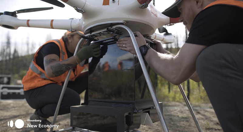
A apparatus for dropping seed vessels is attached to a drone after being reloaded with tree seeds. Bloomberg image.

DroneSeed, a company that uses fleets of drones to reforest areas burned in wildfires, received approval in October from the Federal Aviation Administration (FAA) for its heavy-lift drones to operate Beyond Visual Line of Sight (BVLOS) and to expand its use of heavy-lift drone swarms to California, Colorado, Montana, Nevada, Arizona and New Mexico. They previously had FAA authorization to operate in Oregon, Washington, and Idaho.

The FAA’s action allows DroneSeed to begin reforesting once a fire is contained and airspace is clear. Their aircraft drop seeds that are encapsulated in vessels consisting of four to six seeds, fertilizer, natural pest deterrents, and fibrous material which absorbs water and increases survivability.

The company has designed a system around a swarm of drones that can drop tree seeds in places where they have a decent chance of survival. First they survey the area with a drone using lidar and a multispectral camera to map the terrain and the vegetation. The next step is to use artificial intelligence to sort through the mapping data to find areas where a dropped seed is most likely to germinate, in order to avoid, for example, rock, roads, and unburned locations. After the aircraft are launched, the five aircraft operate autonomously as they fly grid patterns.

Droneseed
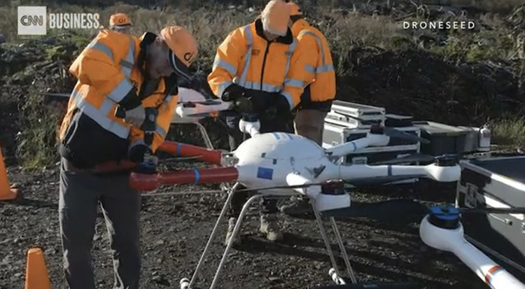
DroneSeed. CNN image

A swarm of five drones can reseed 25 to 50 acres each day, said Grant Canary, CEO of DroneSeed. While on a seed-dropping mission each drone can stay in the air for 8 to 18 minutes, then returns to the helibase where it is reloaded with seed vessels and the battery is replaced. Mr. Canary said it takes about 6 minutes to replace the battery and the 57-pound seed vessel container.

DroneSeed makes their aircraft, they are not off-the-shelf consumer level drones. Batteries power the electric motors that drive the propellers. When at a work site, the workers bring five batteries for each aircraft which are recharged with a proprietary charging system run off a generator.

The company has about 40 employees, 10 of whom may be manufacturing seed vessels for ongoing or upcoming reseeding projects.

The company is already reforesting some of the areas burned this year in the one million-acre August Complex of fires in Northern California, and the 173,000-acre Holiday Farm Fire in Oregon.

While most aircraft hired by land management agencies are paid by the flight hour and daily availability rates, DroneSeed charges by the acre.

After sites are selected, seed vessels are manufactured, in many cases containing native Douglas Fir or Ponderosa Pine seeds harvested from the general part of the country where they will be later dispersed.

Currently DroneSeed is the only company in the United States approved to operate with heavy-lift drone swarms, according to the company.

The video below describes the reseeding system beginning at 0:32 and ending at 3:52.

Thanks and a tip of the hat go out to Rick.

Wildfires have burned over 800 square miles in Oregon

Four fires east of Interstate 5, from Portland south to Eugene, are each larger than 100,000 acres.

map fires Oregon Portland
Map showing heat detected by satellites within the last 24 hours on fires in the Portland-Eugene area, Sept 10, 2020.

At least 50 fires have burned over 800 square miles in Oregon, and again on Wednesday, dry, breezy weather kept them growing.  Governor Kate Brown said that during this fire siege the state will likely experience the greatest loss of property and lives from wildfires in its history. This a result of the confluence of several factors, including drought and lightning, along with hot, dry, and very windy weather.

The Oregon Office of Emergency Management has created an interactive website to help provide information about evacuations statewide.

The Beachie Creek Fire 17 miles east of Salem started August 16. On September 6 it was 469 acres but the historic wind storm the next day caused it to grow overnight to 131,000 acres. On September 9 it was mapped at 182,000 acres and was 19 miles east of Salem. Fire personnel had to evacuate their incident command post after electrical lines and transformers were destroyed during the wind event. An update from the incident management team on September 9 said “mass evacuations are being planned”. The east side of the Beachie Creek Fire has merged with the Lionshead Fire. The fire organization has a Facebook page with evacuation information.

The 109,223-acre Lionshead Fire started August 16 on the Confederated Tribes of Warm Springs Reservation 14 miles west of the Warm Springs community and has spread to the Willamette National Forest merging into the east side of the Beachie Creek Fire. It is actively growing on the west side of the Cascades. Long range spotting contributed to the fire spreading for 12 miles reaching areas near Breitenbush and Detroit Lake. The fire also crossed highway 22 in multiple places.  More information can be found on Facebook.

The Holiday Farm Fire, also known as the McKenzie Fire, has burned 144,694 acres about 14 miles east of Eugene. Evacuations are in effect; the Lane County government and  Linn County Sheriff’s office has more information. On Wednesday fire behavior and weather conditions were still treacherous and kept firefighters from accessing many areas, but they were able to protect some structures by burning out around them to remove flammable vegetation. Winds on Thursday are expected to shift and begin blowing out of the west and relative humidity is expected to be in the low teens.  These weather conditions may contribute to another day of very active fire behavior.

The 120,000-acre Riverside Fire is southeast of both Oregon City and Portland. Most of the spread in the last 24 hours was on the southwest and northwest sides. The blaze moved four miles down the Clackamas River corridor towards the communities of Estacada and Springwater. Crews worked overnight to continue point protection efforts on homes and other critical infrastructure in that area and along Highway 211. On Thursday firefighters hope to take advantage of predicted lighter winds during the afternoon to conduct critical air operations. However, changing wind directions throughout the day could spur additional fire growth in multiple directions. Thursday morning fire officials estimated it was approximately two air miles from the community of Estacada, Oregon. The Clackamas County Sheriff’s office has information about evacuations that are in effect.

The Echo Mountain Complex has burned 2,297 acres south and east of Otis at the intersection of Highways 101 and 18. Evacuations are in effect. It is burning on both the north and south sides of 18. The Oregon Department of Forestry reports that local firefighters and ODF personnel have been out in force around the clock on the fire lines, but outside help is very limited due to the large number of fires across the state. Matt Thomas of ODF said Wednesday there has been no containment yet, and that may not happen for an extended period of time. More information is on the ODF’s West Oregon District Facebook Page.