Aircraft busy on North Carolina fire

State and federal crews are battling a wildfire that started on western North Carolina’s Nantahala National Forest — one of four national forests in the state.

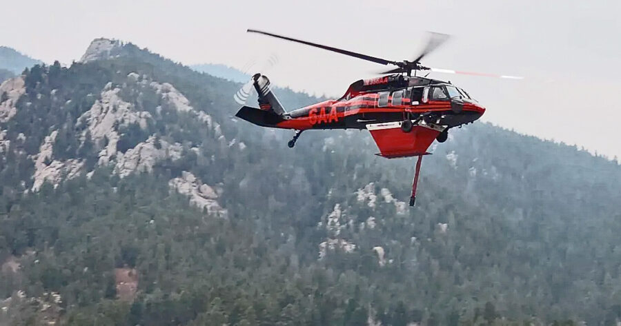
North Carolina SEAT
A new Kodiak 100 owned by the State of North Carolina on the Collett Ridge Fire. Ron Stamey photo.

WLOS-TV reported that the Collett Ridge Fire had grown to 52 acres by Wednesday the 25th and was burning toward Junaluska Road. Earlier today it was estimated at 90 acres. Both USFS and North Carolina Forest Service personnel are working on the fire.

“Given the rough and rugged terrain, an airtanker has been ordered to assist the two helicopters and other firefighting resources on scene,” officials said.

Collett Ridge Fire
Lightning started the Collett Ridge Fire on October 23 on the Cheoah-Tusquitee Ranger District of the Nantahala National Forest. USFS photo

The Southern Scoop News reported that the fire was ignited by lightning on the top of Collett Ridge on October 23 and has been backing down the ridge to the north.

David Ilse, Acting District Ranger for the Cheoah-Tusquitee Ranger District, said fire growth today was minimal because of the cloud cover and higher relative humidity over the fire area. “We are using aerial resources and are working to place crews safely on the ground,” he added.

The fire grew on the northwest corner, with backing fire and 6-inch flame lengths. Crews yesterday scouted the terrain and fuels of the Bolden Creek drainage to determine where best to put in a fireline and locations for planned safety zones. A helicopter with a bucket dropped water on hot spots.

Crews were establishing hand line today from Collett Creek Road to Bolden Creek and then from Bolden Branch Road over to Lords Way down to Junaluska Road — incorporating trails, creeks, and the existing road system. Aviation crews were working the fire perimeter throughout the day.

North Carolina Forest Service fire stats
   North Carolina Forest Service fire numbers

Earlier this month, fire officials warned residents about the dry conditions. North Carolina Forest Service District Ranger Brian Rogers said at this time of year, even yard cleanup can be a fire risk.

“If they’re going to be burning leaves or debris, make sure that they have tools on hand,” he said, “water hose, shovels, buckets, something that they can extinguish their fires with and make sure they’re fully out.”

He predicted the fire risk would worsen if rainfall amounts didn’t improve.

“Some of the areas here in western North Carolina are 10 to 25 percent below normal precipitation,” said Rogers.

Yesterday North Carolina Forest Service Ranger Bo Dossett told ABC45 News that conditions are extremely dry and fire-prone. “Sometimes when there are big dead trees on a ridgeline and we get long periods of dry weather like this, those dead trees can become a new source of ignition when we get lightning like we did last week. Stream flows are down, water tables in the forest are lower. It makes fires harder to control,” he said.

Sheriff STILL investigating arrest of burn boss

It’s been just over a year since the Grant County Sheriff in eastern Oregon kicked over a hornets’ nest and made national headlines by arresting and handcuffing a Forest Service burn boss for “reckless burning” while he was directing a planned and active prescribed fire. And the case is still under investigation.

“It is wrapping up,” Sheriff Todd McKinley recently told the Blue Mountain Eagle. He said he plans to forward the investigation to the district attorney “in the near future.”

On Oct. 19, 2022, Ricky Snodgrass was overseeing the Starr 6 Burn in Bear Valley, on the Malheur National Forest about 17 miles south of John Day and 7 miles north of Seneca, when embers blew over the Izee-Paulina Highway and scorched 15 or 20 acres of private land belonging to the family-owned Holliday Ranch.
Holliday Ranch in Grant County, Oregon
Red angus on the Holliday Ranch in Grant County, Oregon

Snodgrass, 39, was the USFS burn boss managing the 300-acre Rx fire — the second Malheur NF burn within about two weeks — and those on the fire included not only federal crews but also Grayback contract crews and Oregon Department of Forestry personnel.

Burn Boss arrest: Starr 6 RxFire
19. October 2022 — Burn Boss arrest: Starr 6 RxFire in Grant County, Oregon

Landowners called the sheriff to report the burn had started a spot fire and was “out of control.” With the burn underway and with long-running tensions escalating between the property owners and fire crews, Snodgrass also called the county sheriff — to help control aggressive traffic and to deal with harassment his crews had been subjected to. Much to Snodgrass’ surprise, McKinley arrested him on “suspicion of reckless burning” — and took him away in handcuffs while the fire was still burning.

Timothy hay on the eastern Oregon Holliday Ranch.

Firefighters who remained on the job brought the private land slopover under control in about an hour; they also maintained control of the prescribed burn on national forest land.

Grant County Sheriff Todd McKinley

Snodgrass was driven to the county jail, where he was officially booked and then quickly released.

The Starr 6 Burn very quickly hit the news and ignited controversy — far beyond Oregon and the wildland fire community. The story was picked up by news organizations  including the Washington Post, The Guardian, NBC News, ABC News, Reuters, and others.

It was one of the first prescribed fires initiated after new restrictions and guidelines were established in early 2022 — rules that followed a 90-day stop-work after New Mexico prescribed fires escaped — the Calf Canyon – Hermit’s Peak fire burned several hundred thousand acres and hundreds of structures early in 2022.

Forest Service Chief Randy Moore quickly vowed he would “not stand idly by” after this first-ever arrest, and that he and others would defend USFS employees. The head of the NFFE union said the sheriff interfered with a federal employee in the course of his duties.

Since his arrest a year ago, Ricky Snodgrass has been waiting to hear whether he might face criminal charges in Grant County. District Attorney Jim Carpenter will consider several possible options, depending on the evidence collected and how he assesses it.

Sheriff McKinley also may find out he’s been charged with a crime. Firefighters at the burn during the arrest warned the sheriff that if he detained the burn boss, who was in the middle of conducting a prescribed fire and acting in an official capacity in command of the personnel and their safety and also that of neighboring county residents, he could face charges of obstructing a federal employee during the performance of duties.

McKinley recently told the Blue Mountain Eagle that he doesn’t know whether charges might be filed against him. “I haven’t even been talked to,” he said.


Tony Chiotti, ace reporter with the Blue Mountain Eagle in John Day, wrote this in-depth report after the arrest, re-published on 10/26/22 by WildfireToday.

Colorado fire grows to over 300 acres

The Saint Charles Fire in Pueblo County was estimated at 266 acres Tuesday morning, October 24, and still at zero percent containment. The incident management team said warm temperatures and the lack of humidity recovery overnight had caused the fire to grow substantially, and the Pueblo Chieftain reported today that the fire is now over 300 acres.

Saint Charles Fire
Saint Charles Fire photo by Pueblo County Sheriff’s Office

The Saint Charles Fire started October 14. Additional resources have been ordered and are arriving daily.

Crews reported slightly increased humidity and cooler temperatures yesterday, but further warm and sunny conditions were forecast for Wednesday, with shifting light winds picking up in the afternoon. Stronger winds out of the west at 11-15 mph with gusts up to 20 mph were predicted for Wednesday by late evening, with increased winds and fire activity resulting in further smoky conditions.

About 170 firefighters are working on the fire.

St. Charles Fire
Sikorsky UH-60A helicopter at work on the Saint Charles Fire — from the incident facebook page.

Resources include three helicopters, two SEATs, and three large airtankers, along with an air attack aircraft.

Four nearby neighborhoods are on pre-evacuation notice, including Tara J, Simonson Meadows, Aspen Acres, and the entire San Isabel area; the Pueblo County Sheriff issued a burn ban for the county until the fire is contained.

According to the Custer County Sheriff’s Office, the fire is about a half mile from the Custer County line.

Surviving relatives sue Forest Service over flash flood deaths

Family members of three people who were killed last year in a flash flood that originated from the burn scar of the largest wildfire in New Mexico’s recorded history are suing the U.S. Forest Service. The wrongful death lawsuit, according to a PBS report, was filed earlier this month and alleges the USFS was negligent in managing the original prescribed burn and also failed to close roads and prevent access to areas at risk of flooding after the Hermit’s Peak – Calf Canyon Fire.

Calf Canyon -Hermits Peak Fire at Highway 434, May 10, 2022. Inciweb.

Three people from west Texas were vacationing at a family cabin in northern New Mexico in July of 2022 when seasonal monsoon storms hit the burn scar near Tecolote Creek. The resulting flash flood swept the three people to their deaths.

The lawsuit also contends that the USFS failed to warn the victims about the dangers of the wildfire and of potential flooding in the area. Neither the USFS nor the USDA has formally responded to the lawsuit, which states that the USDA did not provide a settlement offer or a denial of the claims that were initially filed in the case earlier this year.

The escaped fire burned more than 341,000 acres between early April and late June in the Sangre de Cristo Mountains and was the largest of the record-breaking New Mexico fire season; it was in fact the largest of 2022 in the lower 48 states. It burned over 900 structures, including several hundred homes, and threatened more than 12,000 other structures in the area. A smoldering prescribed fire project rekindled and escaped control, merging with another prescribed burn that had also escaped. The combined fires burned for months.

The Las Dispensas prescribed fire, 1:07 p.m. MDT April 6, 2022. USFS photo.
The Las Dispensas prescribed fire, 1:07 p.m. MDT April 6, 2022.  USFS photo

Congress allotted nearly $4 billion to compensate victims, and FEMA has paid over $101 million so far. Many families, though, complain that the federal government is not acknowledging the extent of the damage or the emotional toll the fire has taken, according to a Denver7 report.

FEMA has paid out just 2 percent of the fund designated to help wildfire victims rebuild. Some can’t wait much longer, and Source NM reported last month that many survivors are in limbo as they await compensation for the fire.

Test fire for the Las Dispensas RxFire in early April of 2022.

The prescribed fire was originally planned to reduce the risk of wildfire. The first small spot fire occurred at 1:35 and was controlled. At 2:26 another quarter-acre spot fire was caught.

Radio communication with some of the personnel was discovered to be a problem. It was later found that Bravo Holding was using a separate “crew net” and was not monitoring the planned frequency.

Ignition stopped a couple of times as spot fires were suppressed, but by about 4 p.m. when the RH dropped to 10 percent there were at least a dozen spots. Shortly thereafter the burn boss requested contingency resources and all resources were pulled off the fire. At 4:25 a dispatcher reported that the contingency resources were actually in Taos, New Mexico, 70 miles away, at a training exercise.

About 4 hours after ignition began, a dispatcher told the agency administrator that the burn boss and FMO recommended it be declared a wildfire; the administrator made the wildfire declaration and the Las Dispensas burn officially became the Hermits Peak Fire.

An 80-page report (4.7Mb PDF) by the USFS later concluded that management of the prescribed fire generally followed the approved prescribed fire plan for most — but not all — of the parameters. The people on the ground thought they were within (or close to) the prescription limits, but fuel moistures were lower than they realized and the increased heavy fuel loading after fireline prep also contributed to increased risk of escape.

FROM THE REPORT:  “We ask them to make up ground on long-needed and far-behind proactive restoration work while barely allowing time to recover from a previously taxing wildland fire response and preparing to respond yet again. We ask them to restore fire process to ecosystems that have evolved to burn, but many of which are now primed for extreme fire behavior due to our own decisions to exclude or suppress fire in these areas.”

PG&E plan to bury lines is shot down

Pacific Gas & Electric — one of the nation’s largest utilities whose equipment has ignited some of California’s deadliest wildfires — wants to bury powerlines in some of its most at-risk areas to prevent fires like the 2018 Camp Fire, started by PG&E lines, that killed 85 people and burned the town of Paradise to the ground. Estimated total cost of the Camp Fire was about $422 billion.

11/08/2018 Camp Fire, NASA satellite image.

But state regulators are balking at the utility’s plan, the Associated Press reported, because it would take too long and cost an estimated $5.9 billion. The company’s customers, who already pay some of the highest rates in the country, would have to foot the bill.


UPDATE 10/18/2023:   According to a KEZI-TV report, Pacific Power recently announced it will receive $150 million in federal grant funding to improve its infrastructure for grid resilience and wildfire mitigation. The funding is from the U.S. Department of Energy, with just under $100 million earmarked for PacifiCorp’s grid resiliency project to reduce the effects of extreme weather on the grid serving disadvantaged communities at highest wildfire risk. An additional $50 million is earmarked for PacifiCorp’s Resiliency Enhancement for Fire Mitigation and Operational Risk Management project.


Regulators want PG&E to put protective covers over many of its overhead powerlines instead of burying them. The cover approach is cheaper, but riskier. PG&E says that burying a powerline reduces the chance it will start a fire by 99 percent because it can’t be blown down by windstorms. The protective cover would reduce that chance by just 62 percent.

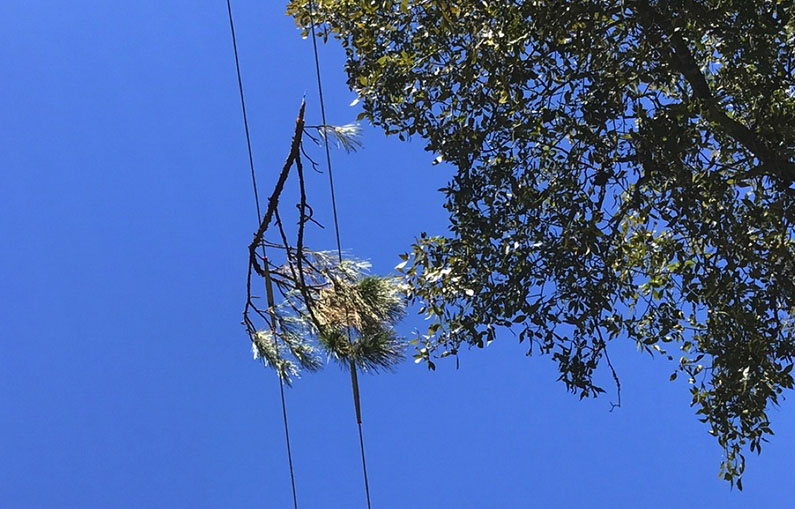
tree limb on lines
Vegetation can cause faults and fires electrically. Distribution Fault Anticipation can detect this type of vegetation fault before the dangerous situation escalates. (Texas A&M Engineering)

MyMotherLode.com reported that the company is hoping to bury 2,100 miles of powerlines by 2026. But the California Public Utilities Commission (PUC), whose members are appointed by the governor, has not signed off on the plan, out of concerns about the estimated cost.

The Manteca Bulletin reported that customers would be expected to pay PG&E at least $40 more per month; the burying plan was put forth after the utility’s lowest rates were increased 170 percent or more since 2006.

PG&E originally wanted a 26 percent increase, and is now asking for an 18 percent increase. The PUC said they’d consider a maximum of 13 percent.

PG&E filed for bankruptcy protection in 2019 after it faced more than $30 billion in damages for wildfires started by its equipment. The company prefers the burying plan, which it filed with state regulators last year.The PUC will likely decide the issue in November.

California this year got off easy — SO FAR

The acreage burned to date in California is less than a third of the state’s 5-year average, according to Cal Fire, and experts attribute the lower numbers to the historic winter storms and a record snowpack in the Pacific Southwest. But those “atmospheric river” storms resulted in huge fuels growth that could, with gusty autumn winds, mean wildfires into November or even December.

“Now is not the time for people to let their guard down,” said Brian Newman, assistant chief of Cal Fire’s Amador-El Dorado Unit. “We still have fire season ahead of us before we get into winter rains that would finally end it.”

Rim Fire, 2013. Inciweb photo
2013 Rim Fire, inciweb photo.

California’s dry, windy, and hot weather conditions from spring through late autumn can produce moderate to severe wildfires. Pre-1800, when the area was much more forested and the ecology also much more resilient, 4.4 million acres of forest and shrubland burned each year. California land area totals about 100 million acres; since 2000 annual burned acreage has ranged between 90,000 acres (0.09 percent of the state), and 1,590,000 acres (1.59 percent).  During the 2020 wildfire season alone, over 8,100 fires contributed to the burning of nearly 4.5 million acres of land.

According to the Sacramento Bee, with 317,191 acres burned so far this year, that’s under 30 percent of the 5-year average of 1.2 million acres for the same year-to-date period. Even though this season’s totaled a “normal” number of new fires, the extra precipitation and cool nights kept the acreage down. Without a dramatic weather change in the next couple of months, California will be experiencing its second straight year of mild wildfire season.

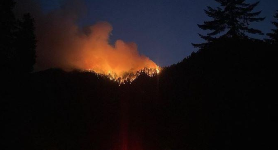
Smith River Complex
Nighttime on the Smith River Complex, inciweb photo by Adan Castillo Uribe.

Last year, fewer than 363,000 acres burned. This year’s largest fire, the Smith River Complex near the Oregon border, totaled 95,017 — under 100,000 acres. In 2020 approximately 4.3 million acres burned, and in 2021, 2.6 million acres. Climate scientists are confident that warming temperatures have increased the severity and length of fire seasons, but many hesitate to actually attribute California’s mild 2023 wildfire season to climate change. “I tend not to give much credence to the idea that single events and single summers or winters can be ascribed to climate change,” said Hugh Safford, chief scientist of Vibrant Planet and faculty at the UC Davis Department of Environmental Science and Policy.

“There’s no question that climate warming is having a major impact on expanding the fire season and increasing severity,” he said. “But California has the highest inter-annual variability and precipitation of any state in the United States. It is normal to go from a record wet year to a record — or nearly record — dry year, and that’s just the way it is.”

Mosquito Fire Sept. 2022According to the Daily Mail, Patrick T. Brown, a lecturer at Johns Hopkins University, says he deliberately omitted a key fact in a climate change piece recently published to ensure that editors would run it — the fact that 80 percent of wildfires are human-caused. Brown gave as an example a Nature paper he recently authored, “Climate warming increases extreme daily wildfire growth risk in California.” Brown said the paper focuses exclusively on how climate change has affected extreme wildfire behavior — but ignores other key factors.

He said academic journals now reject papers that don’t “support certain narratives” and said the media focus on climate change as the root cause of wildfires — including the recent devastating fires in Hawaii. Brown wrote in a piece for The Free Press that this distorts a great deal of climate science research.

But the climate models seen by Erwan Monier, associate professor of climate change impacts at UC Davis Department of Land, Air and Water Resources, make him predict that this upcoming year’s combination of a strong El Niño and warmer ocean temperatures could mean another wet year. “This is most likely the configuration that will control California’s climate this winter,” he said, “and will have implications for the next wildfire season. Because if we have another very wet winter, that means we’ll have even more moisture that could again lead to mild fires next year.”

Scientists predict global temperature increases from human-made greenhouse gases will continue. Severe weather damage will also increase and intensify.
What leading researchers in climate change effects (wildfire et al.) have found, though, lines up with what firefighters observe in the field:
      • We already see effects that scientists predicted, such as the loss of sea ice, melting glaciers and ice sheets, sea level rise, and more intense heat waves.
      • Scientists predict global temperature increases from human-made greenhouse gases will continue. Severe weather damage will also increase and intensify.

Global climate change is not a future problem. Changes to Earth’s climate, driven by increased human emissions of heat-trapping greenhouse gases, are already creating widespread effects on the environment: glaciers and ice sheets are shrinking, river and lake ice is breaking up earlier, plant and animal geographic ranges are shifting, and plants and trees are blooming sooner. Wildfires and fire seasons are just a piece of the many changes that are coming — changes that are here now.

All in the family

Two generations of firefighters from one family is not terribly unusual, and three generations is not unheard of, but there aren’t too many three-generation successions who are all pilots. The Venables in California are one of those successions.

Mike Venable has flown fires for the past 43 years, and he is in the third generation of Venables to fly the same aircraft — Cal Fire’s Tanker 73.

Cal Fire's Tanker 73

“My grandfather flew tanker 73. My dad flew a tanker 73, and I’m now flying a number seven three,” he told FOX Weather‘s Max Gorden. Thousands of calls come in to Cal Fire every year, and officials like to say they keep 95 percent of the fires to 10 acres or fewer. Their 60 aircraft at 14 air bases and 10 helicopter attack bases across the state ensure that any fire is no longer than 20 minutes away. California is home to the largest firefighting aircraft fleet in the world.

Venable and other pilots can be en route to a fire in just minutes.

“It is kind of like a pit crew, getting them in and out of here as fast as we can to get back to the incident,” said Brian Risen, manager at Hemet-Ryan. The base keeps up to 58,000 gallons of retardant at the ready.

Cal Fire's S2-T tankers

Another asset for Cal Fire is its air attack planes, the OV-10 Broncos; in 1993 the state began acquiring them to replace the Cessna O-2A Skymasters in previous service.

OV-10 Broncos

Cal Fire ground crews fight fire from below while the pilots provide support from above. “We’ll try to somehow get down in the canyons and around them,” says Venable, “sometimes the houses and the pools or people on the ground – and try to facilitate exactly what his wishes are to get the retardant where he wants it.”

Like most pilots and most firefighters, though, Venable doesn’t see himself as the hero he’s sometimes tagged as. “I come to work every day, and I climb in this beautiful airplane that the taxpayers of this great state provided us, and I go out and I have a great time,” he says.

Pilot, author, publisher: Patricia Osborn

General Aviation News recently reported that Montana pilot and author Patricia Osborn has published an aerial firefighting storybook for kids, The Fire Truck That Could Fly, illustrated by Eric Castleman. The children’s story follows a crew of firefighters aboard a Chinook helicopter as they combat a remote mountain forest fire.

Pilot Patricia Osborn has released her new children’s book, “The Fire Truck That Could Fly,” with illustrations by Eric Castleman.

Osborn is a Montana-based pilot who founded Huey’s Books with a mission to share stories that educate and inspire. A veteran-owned company, Huey’s Books publishes children’s books about military aviation.

“Our mission is to use children’s books to educate kids and adults about aviation and how military aircraft perform some amazing missions,” said Osborn.

Pilot and author Patricia Osborn
Patricia Osborn, the author and a veteran pilot, founded Huey’s Books with a mission to share engaging stories that educate and inspire.


Huey’s Books in August partnered with Sweetgrass Books to help with printing, distribution, and marketing. “With Sweetgrass Books’ help,” said Osborn, “we hope to be available in more stores and libraries.” The book isn’t yet listed on amazon, but stay tuned.

The Fire Truck That Could Fly is reportedly a tribute to the Army National Guard’s work stateside; the book is 8.5 x 8.5 inches, 32 pages in hardcover for $15.95. Eric Castleman’s work illustrates the work of the helicopter crew and the intensity of the wildfire, according to the publisher, and the book’s available in hardcover online at farcountrypress.com or from Sweetgrass Books.

Do let us know if you’ve read this or wish to submit a review.

Deadline extended for Hawai’i disaster assistance

KA ‘OIHANA PILI KAUA
Hawaiʻi Emergency Management Agency

The FEMA deadline for private nonprofit groups and government agencies to apply for disaster assistance has been extended to October 25.

“The extension gives applicants two more weeks to complete their requests,” said James Barros, administrator of the Hawai‘i Emergency Management Agency (HI-EMA). “Many nonprofits have been deeply involved in the disaster response, but they’ve been busy helping the people of Maui to apply for these federal funds; the extension gives them a bit more time to seek these vital resources.”

Hawaiʻi Emergency Management Agency

The disaster declaration covering the August wildfires authorizes funding to reimburse and pay for protective measures and hazard mitigation, including fire mitigation and environmental and historic preservation projects. Private nonprofit organizations — including houses of worship and community groups — may be eligible for financial reimbursement for emergency protective measures, debris removal, or restoration of facilities.

Eligible organizations include those that have provided services during the wildfire response, or those that want to participate in recovery/mitigation efforts, including environmental and historic preservation.

“HI-EMA is the state agency that serves as the connection between FEMA and applicants for Public Assistance funds,” said Barros, “and our personnel can answer questions about the types of expenses and projects that may be eligible.”

To learn more about available grants, check the FEMA assistance page and the Hawai’i Emergency Management Agency site. For details, contact Brian Fisher with HI-EMA’s Resilience team at brian.j.fisher@hawaii.gov.


UPDATE:
The Lahaina Banyan seems to have survived.
This is a DHS photo from Wikipedia.

Lahaina Banyan tree, DHS photo from wikipedia.

The 2-acre Banyan tree in October 2014:
(by Nvvchar – Own work, CC BY-SA 4.0)
undefined