Rain that began falling at about 1 p.m. Friday slowed the spread of the Fairview and Radford Fires in Southern California. By 5 a.m. Saturday weather stations near the fires had recorded amounts ranging from 0.05″ to 0.28″. Much higher amounts were found at a few locations in the mountains east of the Fairview Fire.
The precipitation is expected to continue into Sunday morning.
Precipitation, vicinity of Radford Fire, 24 hours ending 5 a.m. Sept. 10, 2022 Fairview Fire map Sept. 10, 2022
There was a concern that very strong winds generated by tropical storm Kay would cause problems at the fires, but those did not materialize, at least not by 5 a.m. Saturday.
As of 5 a.m. the rain had occurred as far north as Santa Barbara and Edwards Air Force Base. It did not affect the rapidly growing Mosquito Fire 27 miles west of Lake Tahoe, CA.
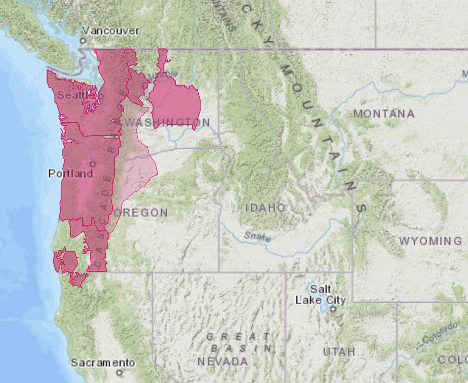
Meanwhile, Red Flag Warnings are in effect Saturday for the northwest corner of California and the west sides of Washington and Oregon.
Red Flag Warnings September 10, 2022
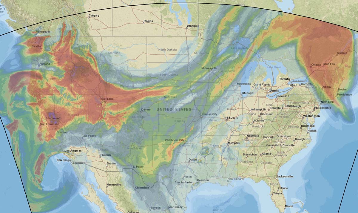
The forecast for vertically integrated wildfire smoke predicts impacts in most of the Western States Saturday afternoon.
Forecast for smoke at 1 p.m. MDT Sept. 10, 2022. NOAA
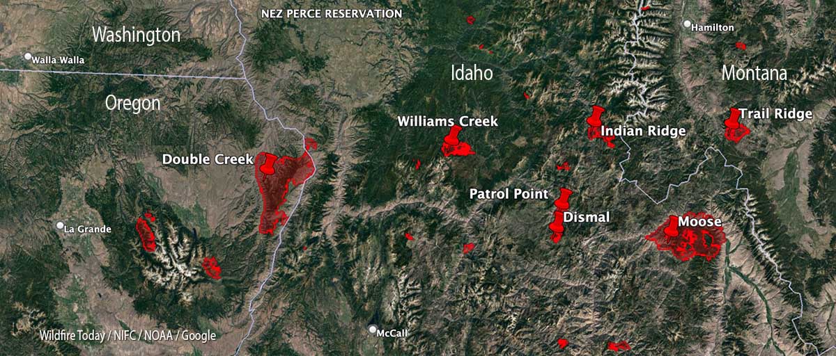
With 35 large uncontained wildfires currently burning in the United States, and many, many more in various categories, we can’t report extensively on all of them, so today we will take a slice of geography and look briefly at seven fires spreading in the Central Idaho area, and extend it just a bit into Oregon and Montana.
Moose (Idaho)
The largest of these seven fires is the Moose, which has been chewing through eastern Idaho since July 17. As far as the cause, the Salmon National Forest says, after almost two months, it is “human caused,” which only eliminates the causes of volcano and lightning. Nine structures have been destroyed. On Friday 650 personnel are assigned to the 125,000-acre blaze which is 5 miles northwest of Salmon, ID. A satellite overflight Friday afternoon only found large heat sources in the southeast portion and that is where an additional 15,000 acres burned Wednesday night, prompting evacuations near Salmon.
Crews reengaged the fire and began preparing new contingency lines along the west edge of the city. Several water pumps, five log decks, and some portable water storage tanks (nicknamed pumpkins because of their shape and color) were destroyed Wednesday. No firefighters were injured. Nearly 500 acres of the city’s Municipal Watershed burned that night, something the various incident management teams had been trying to protect since July.
Cooler temperatures, higher relative humidity, and thick smoke contributed to minimal fire behavior across the fire Thursday.
Indian Ridge (Idaho)
Northwest of the Moose Fire near the Montana border is the lightning-caused 8,670-acre Indian Ridge Fire on the Bitterroot National Forest. It is in the Selway-Bitterroot Wilderness 30 miles southwest of Darby, Montana. The fire has been active this week primarily along the western and northern flanks and north of Indian Creek as it burns through steep, rugged, remote terrain with heavy surface fuels and dead standing timber.
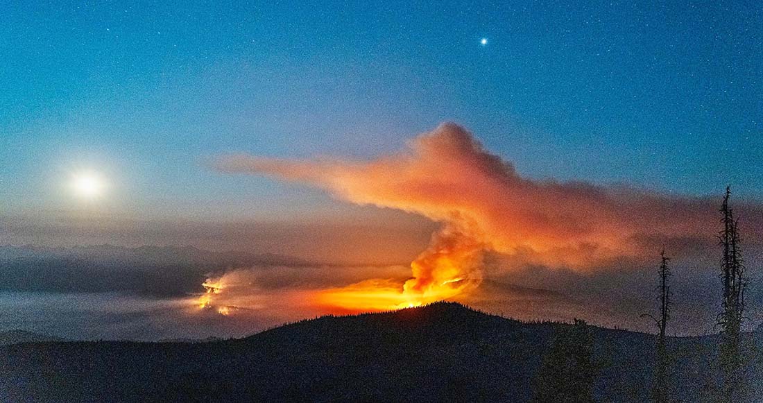
Indian Ridge Fire the night of August 18, 2022. InciWeb.
The fire is not being fully suppressed. Their daily reporting says, “Fire managers are utilizing a point protection strategy to prevent any critical wilderness infrastructure from being negatively impacted by the fire.”
Dismal and Patrol Point
These two fires are very close to merging after significant growth since September 6, and combined have burned an estimated 23,000 acres. They are about 50 miles northwest of Salmon, Idaho. Smoke and the unavailability of infrared mapping aircraft have made it difficult to determine the current perimeters, but there is a lot of new burned acreage between the two fires. Recent low humidity and strong winds are in part responsible for the recent growth.
Areas that fire managers intend to protect include Cold Meadows Guard Station, Root Ranch, and Lantz Bar.
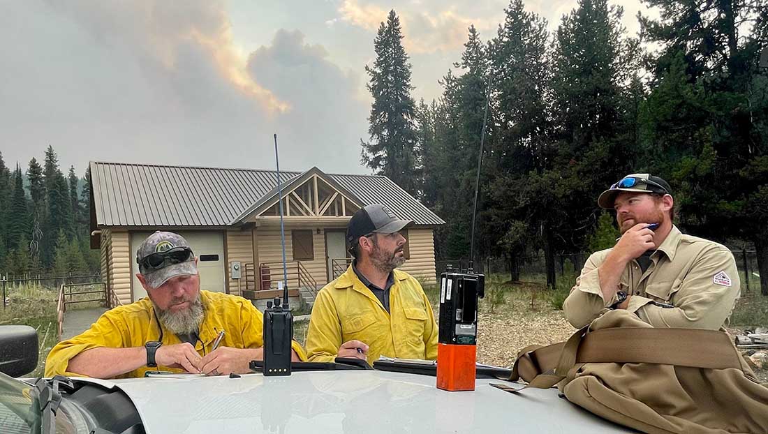
Fire personnel on the Williams Creek Fire in Idaho. InciWeb, posted 9-8-2022.
Williams Creek
The 11,881-acre fire is 5 miles west of Orogrande, near Wildhorse Lake, 7 miles southwest of Elk City, and 8 miles north-northwest of Dixie.
“Resources will continue to engage the fire in Orogrande and the Crooked River corridor, addressing and extinguishing hot spots and conducting damage assessments,” said a September 9 update from the Incident Management Team. “The fire and associated winds did impact structures and outbuildings; crews are still assessing the extent of the damage. Fallen trees, burned snags, and downed power lines continue to present safety hazards.”
Double Creek (Oregon)
The 137,000-acre lightning-caused Double Creek Fire is in Oregon just west of the Idaho border. It has burned to the Snake River in the Pittsburg Landing area. A River Group has been established to assess and protect structures along the waterway. The fire is being fully suppressed and crews are looking for locations to establish the control line farther from Lower Imnaha Road where topography allows. Two structures have been destroyed.
Trail Ridge (Montana)
The 13,000-acre Trail Ridge fire is on the Beaverhead-Deerlodge National Forest in Western Montana about 5 miles east of the Idaho Border and 4 miles southeast of Sula, MT. The cooler weather experienced Thursday and Friday was helpful in slowing the spread of the fire and decreasing the severity of fire behavior. It is burning above 7,000 feet elevation near the Continental Divide and there is no current or expected threat to private land and property. It is not being fully suppressed.
MAFFS training, Boise, April 21, 2017. Photo by Bill Gabbert.
The National Interagency Fire Center (NIFC) has requested two Department of Defense C-130 aircraft equipped with Modular Airborne Fire Fighting Systems (MAFFS) to support wildland firefighting operations in support of NIFC in the northwestern United States. One C-130H from the Nevada Air National Guard’s 152nd Airlift Wing, Reno, Nev., and one C-130J from the California Air National Guard’s 146th Airlift Wing, Port Hueneme, Calif., will arrive at Boise Airport in Idaho today. The aircraft are standing by for flying on behalf of a DoD-approved US Forest Service Request.
“We greatly appreciate the assistance of our military partners,” said Kim Christensen, deputy assistant director for operations for the US Forest Service. “These aircraft will help provide additional capacity for aerial firefighting.”
Having military C-130s that can be converted into air tankers provides a critical “surge” capability that can be used to bolster wildfire suppression efforts when commercial air tankers are stretched thin or an inadequate number remain available for initial attack.
Nationally there are 35 large uncontained wildfires being managed by 26 Type 1 or 2 incident management teams. As of Friday morning 156 helicopters are committed to fires along with more than 17,000 personnel. The number of contracted large air tankers activated was 23, plus 6 water scooping air tankers, before the 2 MAFFS came on board.
Looking at the inside of a MAFFS air tanker, the retardant tank and one of the compressed air tanks. Photo by Bill Gabbert.
Lead plane and MAFFS during annual training in Idaho, April, 2020. Still image from AIRAILIMAGES video.
The National Interagency Fire Center (NIFC) has requested two Department of Defense C-130 aircraft equipped with Modular Airborne Fire Fighting Systems (MAFFS) to support wildland firefighting operations in support of NIFC in the northwestern United States. One C-130H from the Nevada Air National Guard’s 152nd Airlift Wing, Reno, Nev., and one C-130J from the California Air National Guard’s 146th Airlift Wing, Port Hueneme, Calif., will arrive at Boise Airport in Idaho today. The aircraft are standing by for flying on behalf of a DoD-approved US Forest Service Request.
“We greatly appreciate the assistance of our military partners,” said Kim Christensen, deputy assistant director for operations for the US Forest Service. “These aircraft will help provide additional capacity for aerial firefighting.”
Having military C-130s that can be converted into air tankers provides a critical “surge” capability that can be used to bolster wildfire suppression efforts when commercial air tankers are stretched thin or an inadequate number remain available for initial attack.
Nationally there are 35 large uncontained wildfires that are being managed by 26 Type 1 or 2 incident management teams. As of Friday morning 156 helicopters are committed to fires along with more than 17,000 personnel. The number of contracted large air tankers activated was 23, plus 6 water scooping air tankers, before the 2 MAFFS came on board.
A C-130 Hercules, equipped with the Modular Airborne Firefighting System, drops fire retardant April 27, 2011, above West Texas. MAFFS is capable of dispensing 3,000 gallons of water or fire retardant. (U.S. Air Force photo/Staff Sgt. Eric Harris)
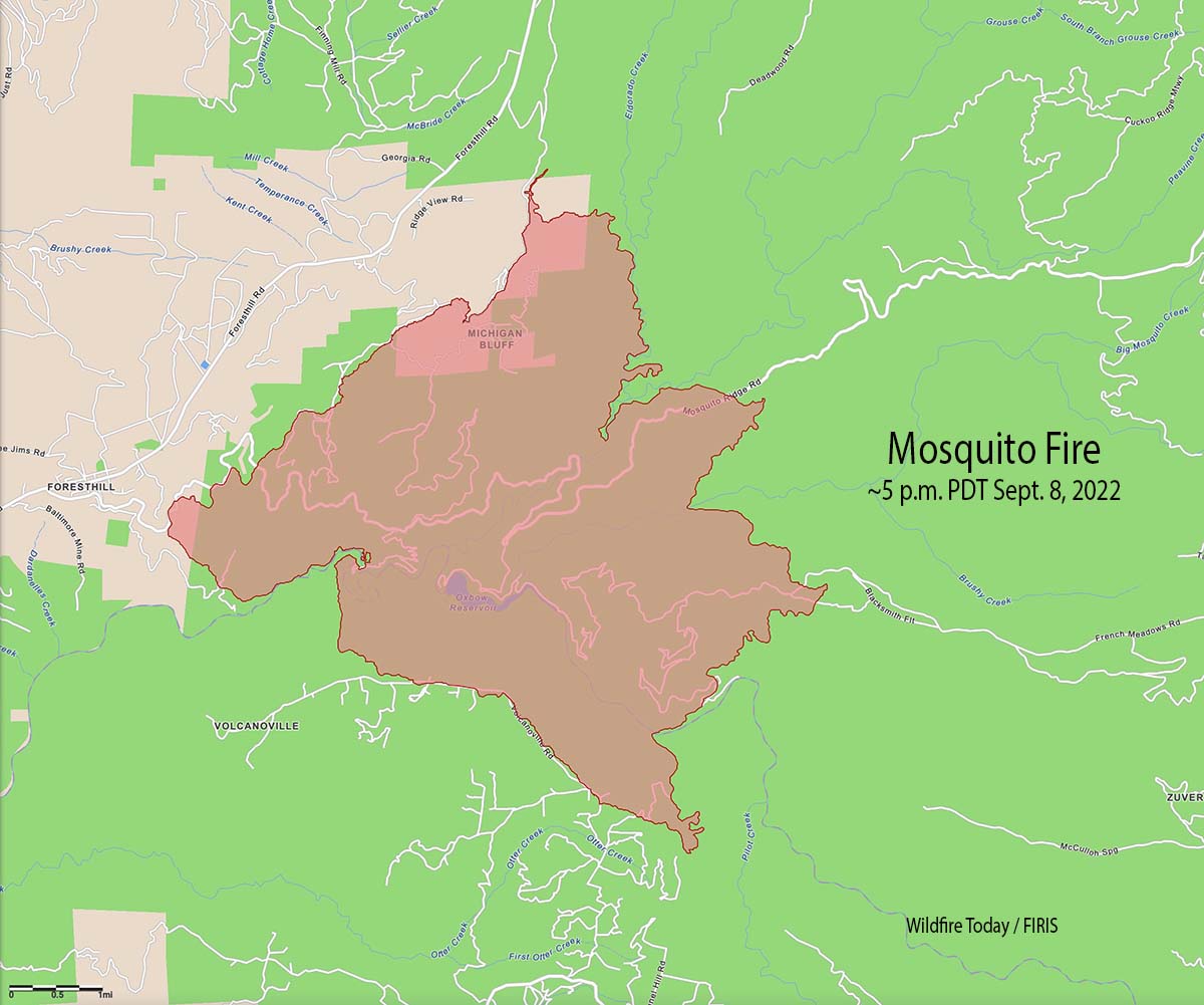
The Mosquito Fire east of Foresthill, California made an impressive run Thursday afternoon, growing from 8,265 acres at 1:30pm to 13,705 acres at 5pm — an increase of 5,440 acres in about 3.5 hours. Most of the growth was on the east half of the fire but the west side spread closer to Foresthill.
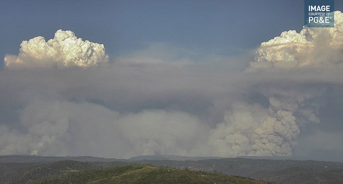
At times the rapidly expanding fire was putting up multiple convection columns topped by pyrocumulus clouds.
Mosquito Fire as seen looking ENE from the Auburn camera at 5:32 p.m. Sept. 8, 2022.
On Thursday structures were being threatened in Volcanoville and Foresthill.
The Goes 17 satellite detected heat and smoke from the Mosquito Fire at 606 p.m. PDT Sept 8, 2022.
On Thursday afternoon the temperature topped out at 101 degrees in Foresthill, the relative humidity dropped to 15 percent, and the wind was only 2 to 5 mph mostly out of the west. The forecast for Friday calls for 102 degrees, 15 percent RH, and winds out of the east and northeast around 5 mph shifting to the west/southwest at 6 to 12 mph in the afternoon with gusts up to 20 mph.
Updated 7:43 p.m. PDT September 7, 2022
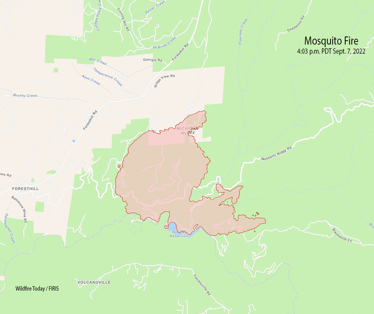
Mosquito Fire map 4:03 p.m. Sept 7, 2022.
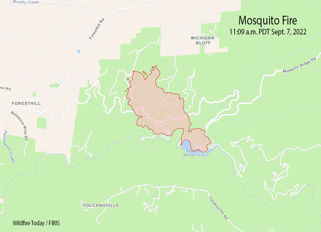
Wednesday afternoon the Mosquito Fire east of Foresthill, California spread significantly north and east. On the north side it moved into the Michigan Bluff area, while on the east side it spread beyond Gorman Ranch Road, along Mosquito Ridge Road, and across Blacksmith Fit.
Mosquito Fire as seen from Bald Mtn Eldorado camera looking north at 6:35 p.m. PDT Sept. 7, 2022.
At about 4 p.m. the FIRIS aircraft mapped it at 4,223 acres, an increase of approximately 3,000 acres since 11 a.m.
Evacuations have been ordered for the Mosquito Fire in the Foresthill area of Northern California, 17 miles northeast of Auburn.
Wednesday morning the fire was about a mile east of Foresthill, and was burning very actively during the afternoon. The estimated size at about 11 a.m. was 1,220 acres.
Most of the fire is within the boundaries of the Tahoe National Forest. It was reported at about 6:27 p.m. Tuesday September 6.
The Placer County Sheriff’s Office has ordered evacuations. They produced a map with the details.
Air tanker 83, an S2-T, drops on the Goose Fire, August, 2016. Photo by Bob Martinez.
The California Department of Forestry and Fire Protection has confirmed that, Ken Lancaster, the pilot killed in the crash of a privately owned small plane Monday afternoon was an off-duty air tanker pilot.
It occurred near Columbia Airport in Tuolumne County, California in the 23000 block of Seminole Drive, about a half mile north of the runway. Mr. Lancaster was flying the personal aircraft off-duty and was the only occupant.
Ken Lancaster. Photo by John Slot.
The personnel who fly and maintain CAL FIRE’s S-2T air tankers and OV-10s work for Amentum. The Modesto Bee reported that the company said Mr. Lancaster began flying for the CAL FIRE program in 2016. He flew OV-10 air attack aircraft and later S-2T air tankers out of Columbia.
During the last four years he worked out of Columbia flying Tanker 83. Previously he was an A-10 Warthog pilot for seven years during his Air Force service, earning the nickname “A-10 Ken,” according to information released by Amentum.
The plane that crashed Monday was a single-engine Barnow Barry Vari EZE, according to the Federal Aviation Administration. It crashed at about 12:10 p.m.
CAL FIRE T-83, an S2T, at McClellan, March 23, 2016. Photo by Bill Gabbert.