
Planned on the Santa Fe National Forest
Continue readingMoose Fire grows to 37,264 acres
Northwest of Salmon, Idaho
Continue readingOak Fire slows, but still spreads into footprint of 2018 Ferguson Fire
CAL FIRE is using one of their new Firehawk helicopters to drop water at night
Continue readingGrass fire burns into Dallas suburb, destroys 9 homes
Another 17 were damaged
Continue readingInterim report released about helicopter crash at Idaho’s Moose Fire
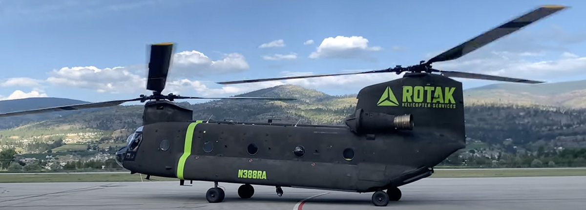 N388RA Boeing CH-47D preparing to take off at Penticton Airport in British Columbia July 16, 2022. Image from VMC Aviation Videos.
The US Forest Service has released a brief initial report about the July 21 crash of the Boeing CH-47D helicopter in the Salmon River while working on the Moose Fire 20 air miles northwest of Salmon, Idaho. The two pilots were killed.
Below is the complete text of the narrative section of the document which was dated July 22, 2022, but was not posted on the Wildland Fire Lessons Learned site until today around noon.
On Thursday, July 20, a call when needed CH-47D Series Chinook Helicopter crashed into the Salmon River, adjacent to the Indianola Work Center approximately 11 miles west of North Fork, Idaho on the Moose Fire. The aircraft sustained severe damage, the pilots were extracted and transported to hospitals but both sustained fatal injuries. The NTSB has been notified and will be conducting an accident investigation. The USDA Forest Service has assigned a learning review team.
The pilots, the only personnel on board, were Thomas Hayes, 41, of Post Falls, Idaho, and Jared Bird, 36, of Anchorage, Alaska.
The helicopter was operated by Anchorage-based ROTAK Helicopter Services.
The FAA confirms that the registration number of the helicopter is N388RA, which is one of two CH-47D ships ROTAK recently purchased from Columbia Helicopters.
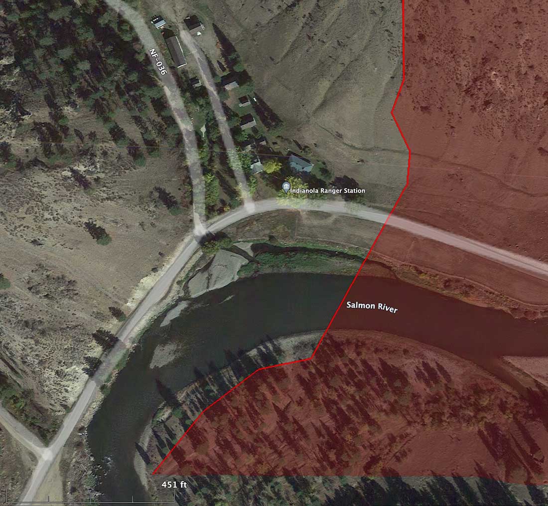 The general area where the CH-47D crashed July 21, 2022. Google Earth. The red shading represents an area burned in the Moose Fire.
There are unconfirmed reports that a hotshot crew was nearby when it crashed and they went into the Salmon River and extricated the pilots in an attempt to save them.
The last time Flight Aware tracked N388FA was at 3:02 p.m. MDT July 21. Because of the rugged terrain, it first showed it north of the Salmon Airport. Then it went northwest generally toward the Moose Fire and lost tracking at 3:12 p.m., minutes before it reached the river.
As an example of the terrain here is a photo of the Comet Fire I took a few years ago from Highway 93 just east of the current Moose Fire, 13 air miles north of Salmon, ID. The Salmon River is in the foreground.
 Comet Fire, July 28, 2016. Photo by Bill Gabbert.
The video below was shot at Penticton Airport in British Columbia July 16, 2022 when it stopped for fuel en route from Alaska to Idaho.
The GoFundMe fundraisers for the two pilots can be found through the following links:
https://www.gofundme.com/f/sup
https://www.gofundme.com/f/tho
Brief initial report released about the Chinook crash into Salmon River
 N388RA Boeing CH-47D at Penticton Airport in British Columbia July 16, 2022. Image from VMC Aviation Videos. It had stopped for fuel on the way from Alaska to Idaho.
The US Forest Service has released a brief initial report about the July 21 crash of the Boeing CH-47D helicopter in the Salmon River while working on the Moose Fire 20 air miles northwest of Salmon, Idaho. The two pilots were killed.
Below is the complete text of the narrative section of the document which was dated July 22, 2022, but was not posted on the Wildland Fire Lessons Learned site until today around noon.
On Thursday, July 21, a call when needed CH-47D Series Chinook Helicopter crashed into the Salmon River, adjacent to the Indianola Work Center approximately 11 miles west of North Fork, Idaho on the Moose Fire. The aircraft sustained severe damage, the pilots were extracted and transported to hospitals but both sustained fatal injuries. The NTSB has been notified and will be conducting an accident investigation. The USDA Forest Service has assigned a learning review team.
The pilots, the only personnel on board, were Thomas Hayes, 41, of Post Falls, Idaho, and Jared Bird, 36, of Anchorage, Alaska.
The helicopter was operated by Anchorage-based ROTAK Helicopter Services.
The FAA confirms that the registration number of the helicopter is N388RA, which is one of two CH-47D ships ROTAK recently purchased from Columbia Helicopters.
 The general area where the CH-47D crashed July 21, 2022. Google Earth. The red shading represents the approximate area Moose Fire, but the portion of the fire at the bottom of the image is cut off.
There are unconfirmed reports that a hotshot crew was nearby when it crashed and they went into the Salmon River and extricated the pilots in an attempt to save them.
The last time Flight Aware tracked N388FA was at 3:02 p.m. MDT July 21. Because of the rugged terrain, it first showed it north of the Salmon Airport. Then it went northwest generally toward the Moose Fire and lost tracking at 3:12 p.m. before it reached the river.
As an example of the terrain here is a photo of the Comet Fire I took a few years ago from Highway 93 just east of the current Moose Fire, 13 air miles north of Salmon, ID. The Salmon River is in the foreground.
 Comet Fire, July 28, 2016. Photo by Bill Gabbert.
The video below was shot at Penticton Airport in British Columbia July 16, 2022 when it stopped for fuel en route from Alaska to Idaho.
The GoFundMe fundraisers for the two pilots can be found through the following links:
https://www.gofundme.com/f/sup
https://www.gofundme.com/f/tho
Giant sequoia trees continue to smolder for up to two years from past wildfires
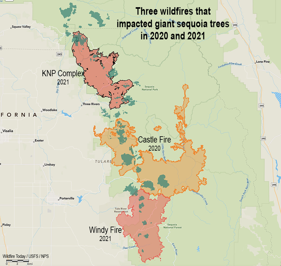 Three fires in two years that killed giant sequoia trees. The darker green areas represent groves of giant sequoias.
The U.S. Forest Service distributed information yesterday saying there are areas still burning in giant sequoia groves after wildfires that occurred in the Castle and Windy Fires of 2020 and 2021.
From the Sequoia National Forest, July 23, 2022:
Three fires were discovered this week, still smoldering inside the 2020 Castle and 2021 Windy Fires. Firefighters from Sequoia National Forest quickly reached two, and the third could not be reached safely due to the dense stand of fire-killed trees surrounding it.
The 1-acre Cougar Fire was found burning in the Red Hill Giant Sequoia Grove near the Tule River Indian Reservation boundary. Less than a half mile away, the ¼-acre Crawford Fire was reported by fire personnel responding to the Cougar Fire. Both were caused by a smoldering giant sequoia tree leftover from last summer’s Windy Fire.
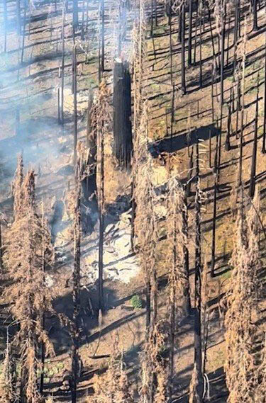 Burning area in giant sequoia grove. US Forest Service. Photo distributed July 23, 2022. (Date of the photo and name of fire not provided)
Fireline was constructed by hand to stop each fire from spreading further. Heavy material: treetops, limbs, and trunks of previous fallen trees continue to smolder underneath these still-standing sequoia trees, weakened by the fire burning inside them. Fire personnel will continue to mop up and extinguish what they can without jeopardizing their safety by having to work under a burning giant sequoia tree. Neither the Cougar nor Crawford Fires pose an immediate risk to nearby communities.
On Thursday, a third fire was reported southeast of Camp Nelson in the Belknap Giant Sequoia Grove. Helicopter personnel located this fire deep inside the burned area of the 2020 Castle Fire. Due to its remote location, numerous standing hazard trees endangering fire personnel, and minimal chance of escape, this fire will be monitored from a distance and by air.
There have been several instances of smoldering trees, most of them large diameter giant sequoias, observed and reported in both the Castle and Windy Fire burned areas. These are likely to continue as dry conditions persist. Firefighter safety is a priority when determining how best to extinguish these types of fires. They may have to be monitored until the trees fall on their own and can be managed safely on the ground.
Thanks and a tip of the hat go out to Bob.
Oak Fire spreads rapidly east of Mariposa, California
It started Friday afternoon
Continue readingWildfire smoke forecast for Sunday morning, July 24
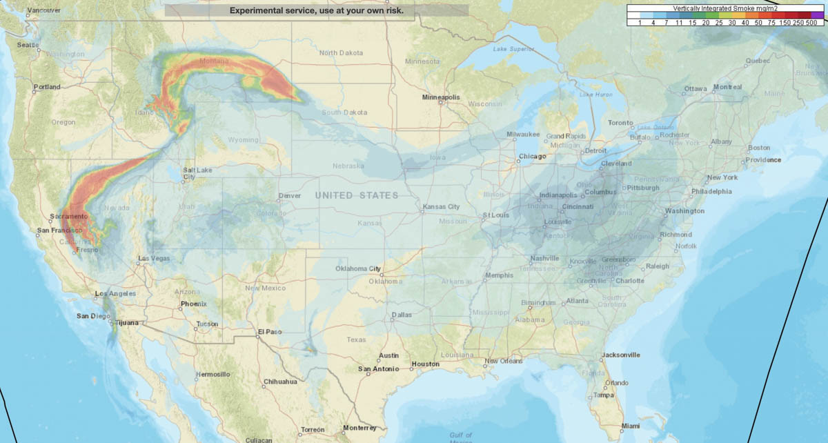 Smoke forecast for the United States at 7 a.m. MDT July 24, 2022. NOAA.
NOAA has produced a forecast for the distribution of vertically integrated wildfire smoke at 7 a.m. MDT Sunday July 24. Locations to be hit the hardest are areas in Northern California, Northern Nevada, Eastern Idaho, and Montana.
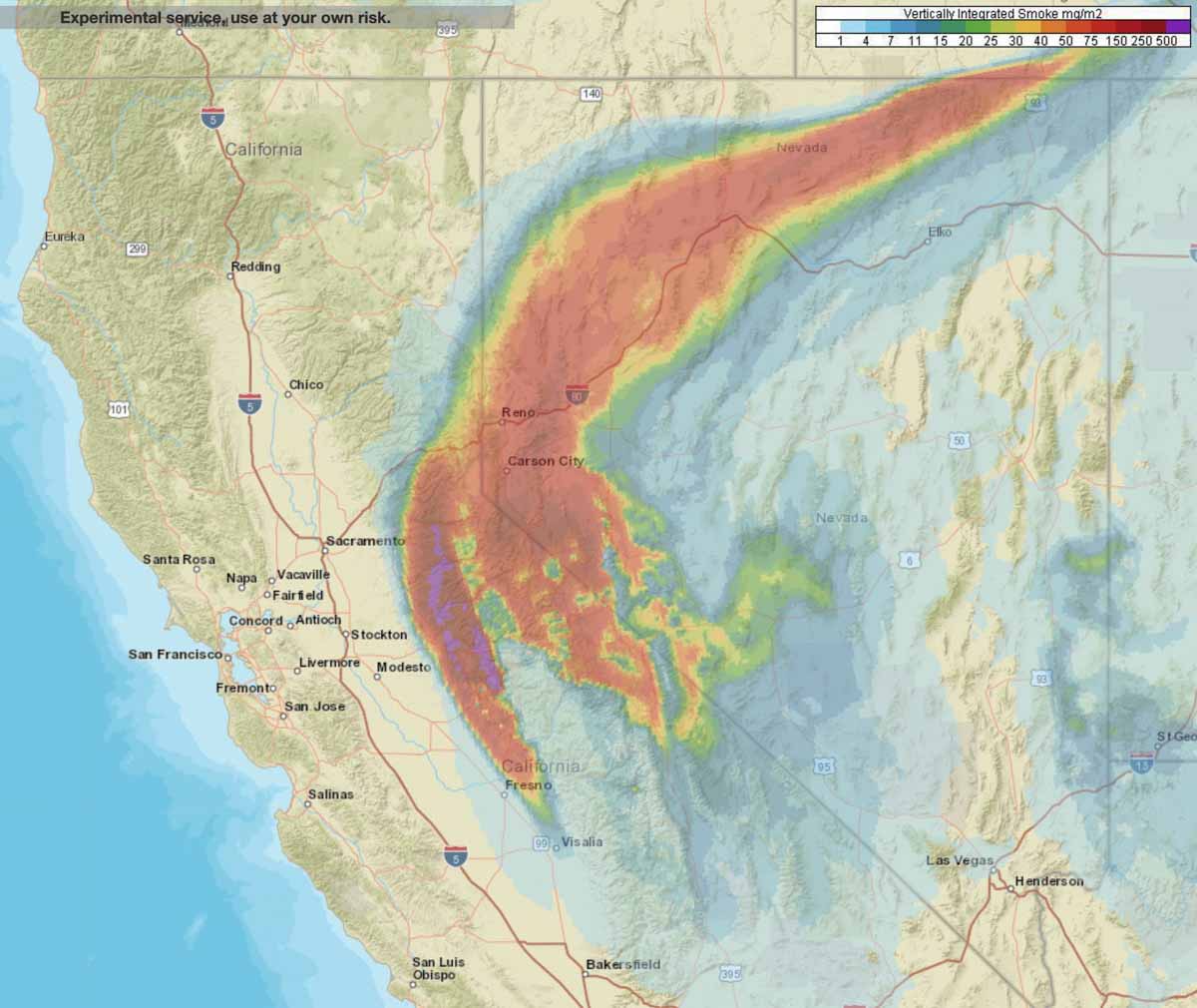 Smoke forecast for Northern California and Nevada at 7 a.m. MDT July 24, 2022.
Moose Fire near Idaho-Montana border grows to more than 28,000 acres
Most of the 5,000 acres of growth was on the west and east sides
Continue reading