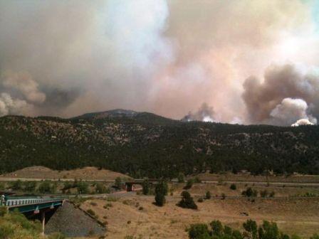
These are not your grandfather’s forest fires

Posted on Categories UncategorizedTags
Smoke from Wallow fire, from space 1815 MT 6-8-2011
Smoke from the Wallow and Horseshoe 2 fires, photographed by a NASA weather satellite June 8, 2011. Notations added by Wildfire Today.

Chip Ward has written an opinion piece for CBSnews.com about the “monster” wildfires that have been turning large swaths of Texas and Arizona black over the last few months. From his home in Utah he does not really break much new ground, but he lays out the current situation in a style that makes it a worthwhile read.

Here is how the article begins:

Arizona is burning. Texas, too. New Mexico is next. If you need a grim reminder that an already arid West is burning up and blowing away, here it is. As I write this, more than 700 square miles of Arizona and more than 4,300 square miles of Texas have been swept by monster wildfires. Consider those massive columns of acrid smoke drifting eastward as a kind of smoke signal warning us that a globally warming world is not a matter of some future worst-case scenario. It’s happening right here, right now.

Air tankers have been dropping fire retardant on what is being called the Wallow fire in Arizona and firefighting crews have been mobilized from across the West, but the fire remained “zero contained” for most of last week and only 18% so early in the new week, too big to touch with mere human tools like hoses, shovels, saws, and bulldozers. Walls of flame 100 feet high rolled over the land like a tsunami from Hades. The heat from such a fire is so intense and immense that it can create small tornadoes of red embers that cannot be knocked down and smothered by water or chemicals. These are not your grandfather’s forest fires.


Thanks Dick

Firelines in the southwest will be tested by strong winds this weekend

The weather this weekend is going to be a serious challenge for firefighters. Beginning today, Friday, the Red Flags are flying.

Red Flag warnings 6-17-2011

As you can see in the map above most of the southwest today is under a Red Flag warning or Fire Weather Watch, and Saturday will be about the same.

The table below summarizes the weather forcast for Luna, New Mexico, which is just east of the Wallow fire. Winds gusting near 40 mph each day with single-digit relative humidity is not what the wildfire managers would like.

Wind Gusts RH Temp
Fri 26 37 7 82
Sat 28 39 9 82
Sun 29 40 8 81
Mon 14 10 79

Below is the weather recorded at the Luna, NM RAWS station Friday:

Weather at Luna 6-17-2011

The wind will be from the west or southwest, which will be blowing roughly up and aligned with the Blue River drainage on the Wallow fire where most of the remaining open fireline remains on that fire. Very little of the drainage will be sheltered from the wind. If the fire crosses, fighting it on the east side in remote, rough terrain is not going to be easy.

The map below shows the southeast side of the Wallow fire. We’re looking up the Blue River drainage toward the northeast. The fire is outlined in red. Click to enlarge the image.

Map of Wallow 3-D SE side 2330 6-16-2011
(Click to enlarge) Map of the southeast side of the Wallow fire, looking northeast. 11:30 p.m. MT, June 16, 2011


Monument fire expands to the north

Update at 12:30 p.m. MT, June 17, 2011: replaced map with updated version.

================================

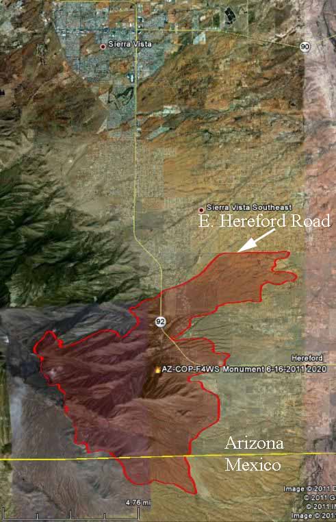
The Monument fire in southern Arizona grew substantially on Thursday, expanding further into the Huachuca Mountains and crossing Highway 92 a second time. It has now blackened a total of 18,580 acres and is 15% contained.

Below is a map of the Monument fire.

Map of Monument fire, 2020, 6-16-2011
Map of Monument fire. A perimeter is shown, current as of 8:20 p.m. MT, 6-16-2011. MODIS/Google Earth

Here is an excerpt from a report on InciWeb, dated June 17 at 8:00 a.m.:

Yesterday’s Activity: Predicted weather conditions and extreme fire behavior resulted in the fire crossing highway 92 at Stump Canyon around 2pm. Firefighters kept the fire south of Herford Road. Tankers and helicopters dropped water and retardant. No structures were lost east of highway 92. Crews continued to look for potential fire danger to structures, developing protection plans for homes. Firefighters continued to reinforce Forest Road 61 on the southwest part of the fire. Fire activity increased in Coronado National Memorial, and crews continued to secure the fire line and mop up hot spots. There was one injury as a result of smoke inhalation.

Today’s Plan: Due to extreme dry fuel conditions, high winds, and single digit relative humidity, a Red Flag Warning is in effect. Firefighters and fire engines are prepared for extreme fire activity. Additional firefighting resources will join the night shift. Crews will finish mop up east of Highway 92. Crews will coordinate efforts will Fort Huachuca fire protection resources to look for opportunities for potential control lines. Crews will prepare fire line from Hunter Canyon to Carr Canyon to continue structure protection. Helicopters and air tankers will be utilized to drop water and retardant to help slow the fire. A structure protection group will continue to look for potential fire danger in the Hunter Canyon area. Crews will work to hold the fire along Forest Road 61 on the southern edge of the fire. Crews will prepare Forest Road 4781 for potential burnout operations.

xxx

Military MAFFS air tankers activated

Update at 8:40 a.m. MT June 18, 2011: Two additional MAFFS aircraft have been activated. The second two are from North Carolina. All four will be based at Albuquerque, NM.

==================================

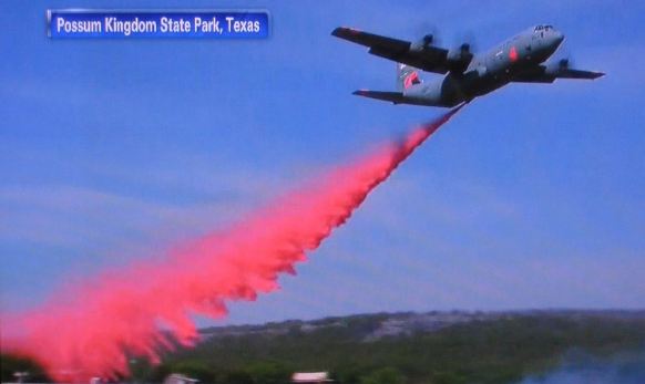
MAFFS C-130 Texas 4-2011
MAFFS C-130 dropping in Texas, April, 2011. CNN

Two Modular Airborne Firefighting System (MAFFS) equipped military C-130 aircraft have been activated and dispatched to the southwest to help fight the numerous large fires that have burned hundreds of thousands of acres this month. The California based air tankers left June 16 for their new temporary base at Kirtland Air Force Base at Albuquerque, New Mexico. The MAFFS air tankers can carry 3,000 gallons of retardant.

There are a total of eight MAFFS units, positioned in four states, two units per state.

In April six MAFFS from military bases California, North Carolina, Wyoming, and Colorado were activated for fires. Four were used on wildfires in Texas, while two were based at Laughlin Air Force Base in Texas but were used on fires about 60 miles away from Laughlin in Mexico. The MAFFS did not see a lot of use in Texas because about the time they were activated humid air moved into the state, slowing the spread of the fires. But two of them were pretty busy in Mexico.

The rules that govern the use of the C-130s require that privately-owned air tankers be fully committed before the military aircraft can be used on fires.

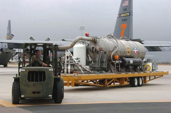
MAFFS 2 tank
MAFFS 2 tank, the new version of the MAFFS, which is loaded into a C-130 when the aircraft is activated as an air tanker.
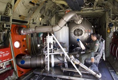
MAFFS 2 interior
The interior of a MAFFS 2, showing the retardant discharge and emergency high pressure air release tubes going through the side paratrooper door. Loadmaster Bill Whitlatch operates a new MAFFS 2 unit aboard a C-130J aircraft with the Channel Islands Air National Guard. Photo by Stephen Osman, Ventura County Star.

HERE is a list of some of the recent articles at Wildfire Today that mentioned the MAFFS air tankers.


IAWF announces Wildland Fire Scholarship winners

The International Association of Wildland Fire announced today the two winners of their Wildland Fire Scholarships for 2011. They are Alexis Lewis and Victoria Pantoja-Campa. Alexis Lewis is studying at Oregon State University and Victoria is at the Universidad Autonoma Chapingo in Mexico.

I don’t have the pleasure of knowing Victoria Pantoja-Campa but I have worked around Alexis on a couple of extended details at Yellowstone National Park when she was working on the helitack crew. Since then she has received her master’s in a wildland fire-related field and now is working on her PhD. She is an extraordinary person, and I am not surprised that people will soon be calling Alexis, who will be working on a fire crew again this summer, “Doc”.

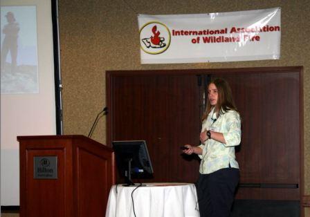
Below is a photo of her that I had sitting around. It was taken at the IAWF’s Human Dimensions of Wildland Fire conference in Colorado in 2007 while she was presenting a paper on “Firefighters’ Experiences of Comfort with Decision Making in Wildland Firefighting”. The proceedings for the conference are here, but they are all in one huge zipped file.

Alexis Lewis 10-23-2007 Hum Dim conf
Alexis Lewis, October 23, 2007 at the IAWF's Human Dimensions of Wildland Fire Conference. Photo: Bill Gabbert for the IAWF

Congratulations to the two women for being winners of the $2,500 scholarships. More details and photos about the scholarships and the two winners are at the IAWF site.

Track fire still active on east side, but Interstate 25 opens

Track fire 6-13-2011
Track fire 6-13-2011. Photo: New Mexico State Forestry

Interstate 25 opens

The Track fire, which required the closure of Interstate 25 at Raton, New Mexico for several days, was still active on the east side on Wednesday, but the west side has been suppressed by firefighters enough to allow the Interstate to open. The highway opened at about 4:00 a.m. on Thursday, much to the relief of drivers who had been forced to take a lengthy detour around the fire to the east of Raton.

Scroll down to see a map of the fire, which has burned 25,620 acres and is 20% contained, according to a report by the incident management team on InciWeb. Here are more details that they posted at 10 p.m. on Wednesday:

Evacuation Update: As of 5:00 p.m. today, June 15, the City of Raton has lifted the evacuation order only in the subdivisions within the city limits of Raton. Residents that are returning should be aware that it is possible that they may be put on a pre-evacuation alert should fire activity change. All remaining evacuations orders remain in place.

Fire Update: Winds were favorable on the south and west side of the fire early in the day which allowed crews to significantly mop-up and secure the burned area along the I-25 corridor. They also made considerable progress with constructing direct fire line and securing the areas near structures on the south side of the fire. All available helicopters and airtankers were utilized to a great extent on the most active areas of the fire.

Late afternoon winds and instable weather created extreme fire behavior where running, torching and crowning was observed on the east side of the fire. The fire made two significant runs to the northeast advancing 300-500 acres. Despite the increased fire activity, firefighters kept the fire from spreading south over Highway 72. Fire personnel will concentrate a considerable amount of resources on the north and east side of the fire tomorrow as a Red Flag Warning is predicted.

The weather on Thursday will not be favorable for firefighters. As you can see in the map below, Red Flag Warnings are posted for much of the Southwest for Thursday.

Continue reading “Track fire still active on east side, but Interstate 25 opens”